The Atlantic coast of Ireland
Fishing regions · Last reviewed 2026-08-15
Full Atlantic exposure with warm water arriving on it — a cold-latitude coast holding fish that have no business being that far north, in front of some of the biggest swell in Europe.
Safety: cliffs and rock platforms — can cause serious injury or death. 7 more points apply here.
Being listed here is not permission to fish. What that meansClose
Access, fishing rights, seasons, licences, local bylaws and permitted methods vary and can change. Check current access, permission, local regulations, closures and restrictions before you travel or fish. FishingHQ describes what the ground is and names who holds the answer; it does not hold the answer itself.
Find the authority for a jurisdiction · What FishingHQ does and does not cover
The Atlantic coast of Ireland is a coast-tier case because two things arrive there at once: the full unobstructed swell of the North Atlantic, and a warm oceanic influence that lifts the water temperature well above what the latitude would give.
THE EXPOSURE IS TOTAL. There is nothing between this coast and North America. Swell generated by storms thousands of kilometres away arrives with its energy intact, as long-period ground swell that can be running hard under a blue sky and no local wind. That is the single most important safety fact about the coast and it is the one that catches visitors, because the relationship between local weather and sea state that holds in the Irish Sea does not hold here.
THE WATER IS WARMER THAN THE LATITUDE. Warm water carried on the North Atlantic Drift reaches this coast, and the effect on the biology is large: the inshore fauna includes species associated with much further south, and the coast holds fish through winters that comparable latitudes elsewhere could not support. It is why Ireland's west has a reputation for species diversity out of proportion to how far north it is.
THE GROUND IS HARD AND DEEP. Cliffs, headlands, boulder shores and reef, with deep water frequently close inshore, cut by bays, sea inlets and drowned river valleys. Kelp forest is extensive. Between the rock lie enormous storm beaches, machair and dune systems, and the deep bays hold sheltered water quite unlike the exposed coast a headland away.
THE FISHERY IS BROAD. Rough-ground and deep-water shore fishing for pollack, wrasse, conger and rays; big-fish shore and boat fishing including tope and blue shark in season; bass in the surf on the southern part of the coast; flatfish and dogfish on the clean ground of the bays; and a boat fishery over reef and wreck. Sea trout and salmon enter the rivers and estuaries, and their management is a matter of considerable conservation concern.
AND THE FRESHWATER IS INSEPARABLE FROM IT. The great western limestone loughs and the spate rivers running to this coast are part of the same fishing landscape, and a visitor here is generally within reach of both.
What fishing here is like
A hard, deeply indented, fully Atlantic-exposed coast of cliff, headland, reef and boulder, interrupted by long storm beaches, dune and machair systems and deep sheltered bays and inlets. Deep water lies close inshore over much of it. Kelp is extensive. Water is oceanic — clear by British and Irish standards — and warmer than the latitude implies. Weather is highly changeable and swell is frequently large and independent of local wind.
What you can target here
One entry per fish, grouped by how you would be fishing — because the answer is a different one from the rocks and from a boat. Each entry says how strongly the sources support it and how much evidence sits behind it. These are documented catches, not a forecast, and none of it is a statement that you may fish any particular ground.
From the shore · 37
 Conger eelRegular local target31 places · 1 recorded catch · 1 sourceBantry Bay, Baltimore and Sherkin, Killybegs harbour, Fenit Pier and 27 moreOver bay, beach, estuary mark, harbour wall, headland, island, pier, promenade, rock mark, rock platform, sound or straitAround JulObserved July 2026
 Ballan wrasseRegular local target30 places · 1 recorded catch · 1 sourceKeem Bay, Achill Island, Kilkee and the Pollock Holes, Baltimore and Sherkin, Malin Head and 26 moreOver bay, beach, harbour wall, headland, island, ledge, pier, promenade, rock mark, rock platform, sound or straitAround Jun–SeptObserved July 2026
 European flounderRegular local target48 placesClew Bay, Galway Bay, Fenit Pier, The Spa, Tralee Bay and 44 moreOver bay, beach, estuary, estuary mark, harbour wall, headland, pier, rock platform, sound or strait, surf beach
- Small-spotted catsharkRegular local target47 placesFenit Pier, Kerry Head, Barrow Harbour, Inch Strand and 43 moreOver bay, beach, estuary, estuary mark, harbour wall, headland, pier, promenade, rock mark, rock platform, sound or strait, surf beach
 PollackRegular local target42 placesKillary Harbour, Kilkee and the Pollock Holes, Bantry Bay, Baltimore and Sherkin and 38 moreOver bay, beach, harbour wall, headland, island, ledge, pier, promenade, rock mark, rock platform, sea loch, sound or strait, surf beach
 Atlantic mackerelRegular local target39 placesClew Bay, Killary Harbour, Galway Bay, Bantry Bay and 35 moreOver bay, beach, estuary, harbour wall, headland, pier, rock mark, rock platform, sea loch, sound or straitAround May–Sept
Also documented from the shore: Dab · European sea bass · Thornback ray · Thick-lipped grey mullet · Saithe · Bull huss · European plaice · Tope · Atlantic cod · Brown trout · Garfish · Turbot · Common stingray · Whiting · Gilthead bream · Grey gurnard · Grey triggerfish · Small-eyed ray · Thin-lipped grey mullet · Three-bearded rockling · Atlantic horse mackerel · Cuckoo wrasse · Edible crab · Lesser sandeel · Lesser weever · Razor clam · Spurdog · Pouting · Atlantic salmon · Flapper skate · Ling
From a boat · 1
On a charter · 4
- Atlantic mackerelRecorded here1 place · 1 fishery account · 1 sourceLoop HeadOver headlandAround AugObserved August 2026
- Cuckoo wrasseRecorded here1 place · 1 fishery account · 1 sourceGalway BayOver bayAround JunObserved June 2026
- PollackRecorded here1 place · 1 fishery account · 1 sourceLoop HeadOver headlandAround AugObserved August 2026
- SpurdogRecorded here1 place · 1 fishery account · 1 sourceGalway BayOver bayAround JunObserved June 2026
What these strengths mean
- Regular local target
- Fishing sources describe this as a normal local target here, not merely as caught.
- Recorded here
- At least one credible public account of this species being caught here. That is all it means.
- Occasional
- Caught here, and described as unusual rather than normal. Do not plan a session around it.
- How breadth is counted
- A fish documented at six marks is shown as six marks: breadth never raises the strength on its own. A fishery account describes the fishing; a recorded catch reports one specific catch. How evidence is weighed.
How people fish here
7 methods are recorded on the places documented here, counted from the records themselves rather than from what is practised in the country. Each opens a full guide to the technique.
Ledgering
Recorded at 77 places here, over pier, surf beach, headland, harbour wall.
Fishing a bait on the bottom held by a weight, with no float — the simplest way to fish at distance, in depth, or in wind.
Documented on the same ground: Atlantic cod, Atlantic horse mackerel, Atlantic mackerel, Ballan wrasse, Brown trout, Bull huss.
Spinning
Recorded at 58 places here, over headland, pier, estuary, beach.
Casting an artificial lure and retrieving it so that it moves like something alive — the most direct form of lure fishing.
Documented on the same ground: Atlantic cod, Atlantic horse mackerel, Atlantic mackerel, Ballan wrasse, Brown trout, Bull huss.
Float fishing
Recorded at 53 places here, over headland, pier, harbour wall, estuary.
Suspending a bait at a controlled depth beneath a buoyant indicator — the most visual, most controllable and most widely applicable method in angling.
Documented on the same ground: Atlantic cod, Atlantic horse mackerel, Atlantic mackerel, Ballan wrasse, Brown trout, Bull huss.
Surfcasting
Recorded at 18 places here, over surf beach, beach, bay.
Casting heavy baited tackle from a beach into surf — a method defined by distance, by tide, and by reading water that all looks the same.
Documented on the same ground: Atlantic cod, Atlantic mackerel, Brown trout, Bull huss, Common stingray, Dab.
Kayak fishing
Recorded at 8 places here, over bay, estuary, harbour wall, sea loch.
A platform rather than a technique: quiet, shallow-draught access to water no other craft reaches, bought at the price of exposure, and a discipline where the decision not to launch is part of the skill.
Documented on the same ground: Atlantic mackerel, Ballan wrasse, Conger eel, Edible crab, European flounder, European sea bass.
Feathering and multi-lure traces
Recorded at 3 places here, over harbour wall, pier.
A string of small lures on droppers, worked in the water column — how most people in Britain and Ireland catch their first sea fish, and the method most likely to catch far more than anybody intended.
Documented on the same ground: Atlantic cod, Atlantic mackerel, Brown trout, Conger eel, Dab, European flounder.
Shore diving
Recorded at 3 places here, over bay, ledge.
Entering and leaving the water from land under your own power — the most accessible spearfishing and the one where the entry and exit are the dangerous part.
Documented on the same ground: Atlantic mackerel, Ballan wrasse, Conger eel, Pollack.
These are the methods documented at the places FishingHQ holds here. A species listed beside a method is documented on the same ground, which is not the same as being taken that way — where a source establishes the method a fish was caught on, it is stated on that place’s own page. All fishing methods.
The fishing year here
The months the records under this area actually name, tightest season first. This is “observed in these months” rather than a season: a species whose months nobody recorded is not listed, because a gap in the evidence is not a year-round fishery.
- Conger eelJuly to July
- PollackAugust to August
- Cuckoo wrasseJune to June
- SpurdogJune to June
- Grey triggerfishAugust to September
- European sea bassSeptember to November
- Common stingrayJune to August
- Ballan wrasseJune to September
- Thornback rayJune to September
- TopeJune to September
- GarfishJune to September
- Gilthead breamJune to September
Areas within this one
7 coasts, island groups and systems inside this area have fishing guides of their own.
Clew Bay and Achill
10 documented places
A nursery bay that was once the most famous skate fishery in these islands, an island coast of exceptionally clear water, and the only true fjord in Ireland, within twenty kilometres of each other.
Documented here: Atlantic mackerel, European flounder, Pollack, Ballan wrasse, European sea bass
Fished by: ledgering, spinning, float fishing, kayak fishing
Connemara and Galway Bay
9 documented places
A coast its own practitioners describe as unexplored rather than poor, where every bay has a river running into it and the flatfish lists say so.
Documented here: Ballan wrasse, European flounder, Pollack, Small-spotted catshark, Thornback ray
Fished by: ledgering, float fishing, spinning, kayak fishing
The Clare coast and the Shannon estuary
10 documented places
Two coasts meeting at Loop Head: Atlantic cliff and rock platform on one side, and on the other a sheltered estuary holding packs of shore tope and thornback ray.
Documented here: Ballan wrasse, Conger eel, European flounder, Pollack, Small-spotted catshark
Fished by: ledgering, float fishing, spinning, surfcasting
The Donegal coast and its sea loughs
14 documented places
The most exposed coast in Ireland with three deep sea loughs cut into it, so the shelter and the open Atlantic are a few kilometres apart and the loughs fish on the days the coast cannot.
Documented here: Atlantic mackerel, Dab, Pollack, Small-spotted catshark, European flounder
Fished by: ledgering, spinning, float fishing, surfcasting
The Kerry coast
19 documented places
Three peninsulas and the shallow warm bay behind them, where four species of ray are named in single sentences at mark after mark and the tide window is stated for each.
Documented here: Small-spotted catshark, European flounder, European sea bass, Thornback ray, Dab
Fished by: ledgering, spinning, float fishing, surfcasting
The Sligo and Leitrim coast
4 documented places
A short coast of very large storm beaches with a shore tope fishery on it, overlooked because the county's reputation was made by its rivers and loughs rather than its sea.
Documented here: Small-spotted catshark, Thornback ray, Tope, Atlantic mackerel, European flounder
Fished by: ledgering, float fishing, spinning, surfcasting
West Cork
17 documented places
Three Atlantic peninsulas and, round the corner from them, a run of shallow estuaries where the statutory guide names gilthead bream and golden grey mullet as ordinary shore species.
Documented here: European flounder, Atlantic mackerel, Pollack, European sea bass, Conger eel
Fished by: ledgering, spinning, float fishing, surfcasting
What dominates
Shore fishing from rock and storm beach, which is the characteristic practice. Lure and fly fishing from the shore for pollack, bass and mackerel, which this coast suits particularly well because of the deep clear water close in. Charter and small-boat fishing over reef and wreck and for shark in season. Kayak fishing in the sheltered bays and inlets only, since the exposed coast is not kayak water. Freshwater game fishing on the loughs and spate rivers immediately inland, which is inseparable from the visitor fishery. Shore gathering of shellfish where local classification and rules permit.
The water available
Fully exposed Atlantic cliff and headland with deep water close in; extensive kelp forest and boulder reef; long high-energy storm beaches with dune and machair behind them; deep sheltered bays, sea inlets and drowned valleys; tidal estuaries and their sea trout and salmon runs; offshore reef and wreck ground; and, immediately inland, large limestone loughs and rain-fed spate rivers.
How the rules are structured
Sea angling in Ireland is not licensed in the way freshwater game angling is, but conservation measures apply and are specific: bass in Irish waters has been subject to particularly restrictive national measures for decades, including bag limits, size limits and a closed period, and those measures differ from the neighbouring jurisdiction's. Freshwater salmon and sea trout angling requires a licence and is governed by river-specific arrangements including catch-and-release requirements and quota tags on many systems. Shellfish gathering is governed by harvest area classification and by biotoxin monitoring. Access to the shore crosses private land in many places and is a matter of local arrangement rather than of right. Northern Ireland operates a separate framework from the Republic on the same island. FishingHQ does not state what any current rule is.
Who to ask
- Inland Fisheries Ireland, for freshwater and for sea angling conservation measures in the Republic, including bass measures and salmon licensing and tagging.
- The Department with responsibility for the marine, and the Sea-Fisheries Protection Authority, for sea fisheries measures and enforcement in the Republic.
- The Food Safety Authority of Ireland and the relevant classification and monitoring programme, for shellfish harvest area classification and biotoxin status.
- The National Parks and Wildlife Service, where a designation affects access or collection.
- The Irish Coast Guard and the RNLI, for safety guidance on this coast.
- The corresponding Northern Ireland authorities where the coast falls within that jurisdiction, which operates separate rules.
Words you will meet
- Ground swell
- Long-period swell generated by distant storms, arriving with its energy intact and independent of local wind. The defining sea-state feature of this coast and the reason a calm-looking day can be unfishable and lethal on rock.
- Machair
- The low, flat, shell-sand grassland behind the storm beaches of the north-west, formed from wind-blown calcareous sand. A distinctive and protected habitat, and the ground a beach angler frequently walks across to reach the shore.
- Storm beach
- A high-energy beach built by Atlantic swell, generally steep, coarse and backed by a ridge of material thrown up in the worst weather. The size of the ridge is the record of what this coast does in winter.
- Lough
- Used on this coast for both freshwater lakes and sea inlets, which is a genuine ambiguity rather than a loose usage — a sea lough is tidal salt water and a freshwater lough is not, and the word alone does not tell you which.
Conditions and hazards
This is among the most dangerous shore fishing in Europe and the reason is the swell. Long-period Atlantic ground swell arrives with no local wind to announce it, and the sea state that matters is generated a continent away — so the relationship between how the day looks and how the sea behaves, which holds in sheltered waters, is actively misleading here. Rock marks with deep water close in are the most attractive and the most exposed, and people are swept off them by sets that arrive without local warning. Cliffs are high and access to shore marks frequently involves descending them. The water is cold enough for cold water shock year-round despite being warmer than the latitude implies, and much of this coast is remote with no mobile coverage, a long way from help and with no realistic prospect of a fast rescue. Weather changes very quickly. The measures that address the mechanism are: read the swell forecast — period as well as height — rather than the wind forecast, watch any rock mark through several full set cycles before committing to it, wear a buoyancy aid, never fish exposed rock alone, tell somebody the mark and the return time, and carry a means of calling for help that does not assume mobile coverage. On this coast, deciding not to fish a mark is routine rather than cautious.
Why a cold-latitude coast holds warm-water fish
The species list on Ireland's Atlantic coast surprises people who arrive expecting a northern fishery, and the explanation is oceanographic rather than accidental.
WARM WATER ARRIVES HERE FROM THE SOUTH-WEST. The North Atlantic Drift carries warm oceanic water north-eastward across the Atlantic and onto this coast, and the effect is to raise sea temperature substantially above what the latitude alone would produce. Ireland's west sits at the latitude of Labrador and does not have Labrador's sea.
THE BIOLOGICAL CONSEQUENCE IS A MIXED FAUNA. Species associated with much further south occur here at the northern edge of their range, alongside the northern species the latitude would predict. That mixture is why the coast has a reputation for species diversity and why a shore session can produce fish from two quite different assemblages.
IT ALSO MEANS THE COAST FISHES THROUGH WINTER. Water that does not fall as far as an equivalent latitude elsewhere keeps species inshore that would otherwise leave, which is why this is not purely a summer fishery.
AND IT MAKES THE COAST A SENTINEL FOR CHANGE. A coast holding species at the northern edge of their range is a coast where a shift in temperature shows up early, in the form of species appearing that were not previously recorded and others becoming less reliable. Anglers here are frequently the first people to notice, which is a real contribution and is also anecdote until somebody records it properly.
THE CLARITY MATTERS TOO. Oceanic water carries much less suspended sediment than the shallow sediment-rich seas to the east, so visibility is generally good. That changes the fishing: lure and fly fishing from the shore works here in a way it does not in turbid water, fish are more easily spooked, and light lines and longer leaders earn their place.
Backed by research — why, and the sources (4)
Supported by peer-reviewed research or fisheries science. The sources are listed and can be checked.
- ICES Advice on fishing opportunities, catch and effort — International Council for the Exploration of the Sea (Scientific institute)Relied on for: Stock distribution, ecoregion boundaries and the physical description of the sea areas assessed, including depth, salinity and hydrography.States this directlyCitation checked — the work exists and is described correctly
- FishBase: a global information system on fishes — Froese, R. and D. Pauly, eds. — FishBase Consortium (Scientific institute)Relied on for: Distribution, temperature tolerance and habitat association of the species named as characteristic of these waters.States this directlyPassage read and verified
- FishBase: a global information system on fishes — Froese, R. and D. Pauly, eds. — FishBase Consortium (Scientific institute)Relied on for: Distribution, habitat association and thermal tolerance of the species named as characteristic of these waters.States this directlyPassage read and verified
- JNCC species and habitat conservation advice — Joint Nature Conservation Committee (Conservation authority)Relied on for: Designation, habitat description and conservation status of the marine and coastal habitats named.States this directlyCitation checked — the work exists and is described correctly
Ground swell: the sea state that has nothing to do with the weather
The most important thing a visitor to this coast can understand is the difference between wind sea and ground swell, because the second one kills people.
WIND SEA IS GENERATED LOCALLY. It is short-period, steep, disorganised, and it corresponds to the wind you can feel. When the wind drops, it drops.
GROUND SWELL IS GENERATED SOMEWHERE ELSE. Storms in the mid-Atlantic or off Newfoundland put energy into the water, and that energy travels as long, low, well-organised waves that lose remarkably little over thousands of kilometres. It arrives days later, under whatever weather happens to be over Ireland at the time — frequently a still, bright, apparently benign day.
LONG PERIOD MEANS HIGH ENERGY. A two-metre swell at eighteen seconds carries vastly more energy than a two-metre wind sea at six, and it behaves completely differently when it reaches shallow water: it stands up suddenly over a reef or a platform and breaks with enormous force. The height figure alone is not the information. The period is.
AND IT ARRIVES IN SETS. Swell travels in groups, with substantially larger waves periodically among smaller ones and long quiet intervals between. A mark that has been comfortable for fifteen minutes has told you nothing about the next set. This is precisely the mechanism by which anglers are swept off rock marks on calm days, and it is why the local discipline of watching a mark through several set cycles before committing exists.
WHAT TO ACTUALLY DO. Read a swell forecast rather than a wind forecast, and read the period as well as the height. Treat any significant long-period swell as a reason to fish sheltered ground rather than exposed rock. Wear a buoyancy aid on rock. Never fish exposed marks alone on this coast. And accept that on a great many days the correct decision is to fish somewhere else, which experienced local anglers do routinely.
Official guidance — why, and the sources (4)
Stated by a fisheries authority, scientific institute or recognised angling body. Authoritative, but summarising rather than demonstrating.
- Rock fishing safety and the declared lifejacket areas of New South Wales — NSW Department of Primary Industries and Surf Life Saving NSW (Water-safety or diver-training authority)Relied on for: Rock-platform fishing hazards, the mechanism by which anglers are swept, and the measures that address it including buoyancy aids and observation before committing to a platform.States this directlyCitation checked — the work exists and is described correctly
- RNLI water safety guidance: cold water shock and Float to Live — Royal National Lifeboat Institution (Water-safety or diver-training authority)Relied on for: Cold water shock, immersion response and the advice to carry a means of calling for help on the person.States this directlyPassage read and verified
- RNLI water safety guidance: cold water shock and Float to Live — Royal National Lifeboat Institution (Water-safety or diver-training authority)Relied on for: Cold water shock and the immersion response, tidal cut-off, and water-safety guidance for shore anglers and small-craft users.States this directlyPassage read and verified
- Met Office shipping forecast, inshore waters forecast and marine warnings — Met Office, United Kingdom (Government fisheries body)Relied on for: That inshore waters forecasts, sea state and swell are the operative inputs for shore and small-craft decisions in these waters.States this directlyCitation checked — the work exists and is described correctly
Salt and fresh in the same landscape
The west of Ireland is unusual in that the sea fishing and the freshwater fishing are not separate activities happening in the same region — they are the same trip.
THE GREAT LIMESTONE LOUGHS lie immediately inland of much of this coast. They are large, shallow, alkaline and productive, and they support wild brown trout fisheries of a kind that limestone geology produces and acid geology cannot. Their mayfly hatches are among the most famous events in European fly fishing and they organise the season around themselves.
THE SPATE RIVERS RUN THROUGH THE SAME GROUND. Rain-fed, flashy, running off hard rock and bog, and carrying salmon and sea trout runs that depend on floods to move fish upstream. A dry summer closes them; rain opens them for a few days.
THE SEA TROUT STORY IS NOT A COMFORTABLE ONE. Sea trout stocks in parts of the west collapsed severely in the late twentieth century, and the relationship between that collapse and sea lice from marine salmon farming has been the subject of sustained scientific and political dispute. It is a live conservation issue rather than a settled one, and a record that presented it as either resolved or trivial would be misrepresenting it.
WHICH IS WHY THE REGULATORY PICTURE HERE IS DENSE. Salmon and sea trout angling in Ireland operates under licensing, river-specific quota and tagging arrangements, mandatory catch-and-release on many systems, and annual assessment of which rivers may be fished at all. Those arrangements change every year by design, because they respond to the assessment. Verifying the current position with Inland Fisheries Ireland before travelling is not a formality on these rivers — it determines whether the trip is possible.
Official guidance — why, and the sources (4)
Stated by a fisheries authority, scientific institute or recognised angling body. Authoritative, but summarising rather than demonstrating.
- FishBase: a global information system on fishes — Froese, R. and D. Pauly, eds. — FishBase Consortium (Scientific institute)Relied on for: Distribution, habitat association and thermal tolerance of the species named as characteristic of these waters.States this directlyPassage read and verified
- JNCC species and habitat conservation advice — Joint Nature Conservation Committee (Conservation authority)Relied on for: Designation, habitat description and conservation status of the marine and coastal habitats named.States this directlyCitation checked — the work exists and is described correctly
- Fishers' Craft and Lettered Art: Tracts on Fishing from the End of the Middle Ages — University of Toronto Press, 1997 (Scientific literature)Relied on for: That fishing traditions develop around the water and fish available to them, and the historical method of reading such traditions.States this directlyCitation checked — the work exists and is described correctly
- General angling website restatements of established technique — Various (Credible secondary source)Relied on for: Widely restated descriptions of regional angling practice, recorded as practitioner consensus rather than as scholarship.Background and mechanism onlyCitation checked — the work exists and is described correctly
The one instinct every angler has, and why it is wrong here
Every angler carries one deeply learned rule: look at the weather, and the sea will follow. On most coasts it is a decent approximation. On the fully exposed Atlantic seaboard it is not merely unreliable, it is inverted often enough to be the thing that kills people, and no amount of general competence corrects it.
GROUND SWELL IS MADE SOMEWHERE ELSE. A depression far out in the North Atlantic — days ago, thousands of kilometres away, over water nobody here can see — puts energy into the ocean. That energy arrives as long-period swell: waves a long way apart, carrying far more energy each than their height suggests, and travelling faster than the weather that made them. So the swell gets here before any weather does, and frequently instead of it. A still, bright, windless morning on this coast can be a morning with a large and dangerous sea running.
AND THE SEA DOES NOT LOOK BIG UNTIL IT ARRIVES. Long-period swell in deep water is a smooth undulation. It becomes a wave when it reaches something — a reef, a shelving ledge, a platform with deep water in front of it. Then it stands up and breaks with all of that energy at once, in a specific place, and the specific places are exactly the marks worth fishing, because deep water close in is what makes them fish.
SETS ARE THE SECOND HALF OF THE MECHANISM. Swell arrives in groups. Twenty quiet minutes on a ledge is not evidence about the next wave; it may be evidence that a set is due. People are swept from marks here on days that were, by every measure an inland eye uses, calm.
SO THE FORECAST TO READ IS NOT THE WIND FORECAST. It is the swell forecast, and the PERIOD as well as the height: a two-metre swell at six seconds and one at sixteen are different animals, and the long one carries several times the energy and reaches further up a platform. Height alone is the number that misleads.
WATCH THE MARK, NOT THE SEA IN GENERAL. Several full set cycles — minutes, not seconds — from above where the water has been reaching, before committing. Choose a platform with a way UP behind it. And accept that deciding a mark is not fishable today is ordinary rather than timid here.
THEN THERE IS THE ARITHMETIC AFTERWARDS. Much of this coast is remote, coverage is patchy or absent, and the walk out with an injury is far slower than the walk in. An incident that would be recoverable near a town is not necessarily recoverable here, which is an argument for not having one rather than for responding well to it. Tell somebody the specific mark and the return time, carry a means of calling for help that does not assume a phone signal, wear a buoyancy aid on exposed rock, and do not fish it alone.
THE WATER IS COLD ENOUGH ALL YEAR to make the first seconds of an immersion decide the outcome, warmer than the latitude implies notwithstanding. Check the current swell and inshore waters forecast on the day, not the day before, because Atlantic weather has a shorter useful forecast horizon here than in sheltered seas.
Official guidance — why, and the sources (3)
Stated by a fisheries authority, scientific institute or recognised angling body. Authoritative, but summarising rather than demonstrating.
- Met Office shipping forecast, inshore waters forecast and marine warnings — Met Office, United Kingdom (Government fisheries body)Relied on for: That inshore waters forecasts, sea state, swell and wind are the operative inputs for shore and small-craft decisions, and the spatial resolution at which those forecasts are issued.States this directlyCitation checked — the work exists and is described correctly
- Rock fishing safety and the declared lifejacket areas of New South Wales — NSW Department of Primary Industries and Surf Life Saving NSW (Water-safety or diver-training authority)Relied on for: Rock-platform fishing hazards, the mechanism by which anglers are swept from platforms by sets rather than by average conditions, and the measures that address it including buoyancy aids and observing the sea before committing to a position.States this directlyCitation checked — the work exists and is described correctly
- RNLI water safety guidance: cold water shock and Float to Live — Royal National Lifeboat Institution (Water-safety or diver-training authority)Relied on for: Cold water shock and the immersion response, tidal cut-off, and water-safety guidance for shore anglers and small-craft users.States this directlyPassage read and verified
Some of what lives here
Fish recorded here that FishingHQ holds a reviewed photograph of. It is not a complete list of what The Atlantic coast of Ireland holds, and it is not a prediction that you will catch any of them — it is a way in to the ones we can show you.
- PollackA fast gadoid that hunts up off reefs and wrecks and takes a lure on the drop — and the sea fish most likely to convert a bait angler to lure fishing.
Wilhelm Thomas Fiege — CC BY-SA 4.0, via Wikimedia Commons
- Ballan wrasseA long-lived rocky-ground resident that begins life female and may change sex — and the species that turned rock marks into a lure fishery.
Diego Delso — CC BY-SA 4.0, via Wikimedia Commons
 European sea bassA fast, predatory inshore fish that hunts in broken water and surf, and one of the most closely managed recreational species in European seas.
Julien Renoult — CC BY 4.0, via Wikimedia Commons
- Atlantic mackerelA fast, schooling, obligate-swimming pelagic fish that arrives inshore in summer in enormous numbers, and the species most sea anglers catch first.
Hans Hillewaert — CC BY-SA 4.0, via Wikimedia Commons
- Conger eelA very large scaleless eel of wrecks, rock and harbour walls, reaching three metres, and among the most powerful and most genuinely dangerous fish to handle in European seas.
Holger Krisp — CC BY 3.0, via Wikimedia Commons
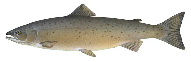 Atlantic salmonAn anadromous salmonid that migrates from its natal river to the North Atlantic and returns to spawn — and a species in serious, well-documented decline.
Knepp, Timothy, Public domain, via Wikimedia Commons
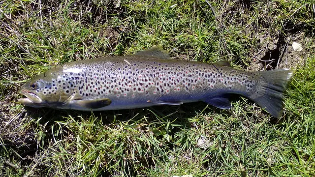 Brown troutA single, extraordinarily plastic species that appears as a tiny hill-stream fish, a deep-bodied loch trout and a silver sea-run migrant — all the same animal.
Robermix, CC0, via Wikimedia Commons
 Thick-lipped grey mulletA shoaling coastal fish that eats algae and detritus rather than prey — which makes it the hardest common sea fish to catch and the most interesting to think about.
Diego Delso — CC BY-SA 4.0, via Wikimedia Commons
Safety
Cliffs and rock platforms — Can cause serious injury or death
Long-period Atlantic ground swell arrives with no local wind and stands up suddenly over reef and rock platform, breaking with far more energy than its height suggests. It travels in sets, so a mark that has been comfortable for fifteen minutes gives no information about the next wave. Anglers are swept off exposed rock on apparently calm days.
What reduces it: Read the swell forecast including the period, not the wind forecast. Watch any exposed mark through several full set cycles before committing to it. Wear a buoyancy aid, never fish exposed rock alone, and treat significant long-period swell as a reason to fish sheltered ground instead. Deciding not to fish a mark is routine here.
Worse when:
- Long-period swell under calm bright conditions, which is the combination that misleads visitors.
- Marks with deep water close in, which are the most attractive and the most exposed.
- Spring tides, which change how far up a platform the sets reach.
Fishing alone — Can cause serious injury or death
Much of this coast is remote, with no mobile coverage, long distances to help and no realistic prospect of a fast rescue. An injury or an immersion a long way from a road is a slow outcome even when somebody knows.
What reduces it: Tell somebody the specific mark and the expected return time. Carry a means of calling for help that does not assume mobile coverage. Do not fish exposed marks alone, and allow for the walk out being far slower than the walk in.
Cold water shock — Can cause serious injury or death
The water is warmer than the latitude implies and is still cold enough year-round to produce an involuntary gasp and loss of breathing control on immersion, in a place where getting out again is frequently impossible without help.
What reduces it: A buoyancy aid worn on rock and in small craft, and the recognition that being able to swim is not the relevant capability in the first minute of cold immersion.
Weather and lightning — Can cause injury needing treatment
Atlantic weather changes very quickly and forecasts have shorter useful horizons here than in sheltered waters. Conditions that were workable on arrival can be untenable within an hour.
What reduces it: Plan a turn-back point and honour it, check the forecast on the day rather than the day before, and treat a deteriorating sky over the western horizon as the signal rather than waiting for confirmation.
Precautions that always apply here
- Wear a buoyancy aid or lifejacket. Cold water incapacitates strong swimmers within a minute, long before swimming ability matters.
- Tell somebody where you are going and when you expect to be back.
- Carry a charged phone in a waterproof case, or another means of calling for help.
- Check the tide before you go and know your exit route. Being cut off is the commonest way a shore session becomes a rescue.
Further safety reading
- Fishing alone — Much of this coast is remote, without mobile coverage, a long way from help and with no realistic prospect of a fast rescue. An injury or an immersion far from a road is a slow outcome even when somebody knows where you are.
- Rock platform and cliff safety — Long-period Atlantic ground swell arrives with no local wind, stands up suddenly over reef and rock, and travels in sets — so a mark comfortable for fifteen minutes gives no information about the next wave. This is the mechanism by which anglers are swept off exposed rock on apparently calm days.
Check the rules before you fish
Fishing laws, bylaws, access rules, seasons, bait restrictions and permitted methods vary by location and can change. Check the current rules from the relevant authority and the water you intend to fish before fishing.
Check with:
- Current national or regional law for where you are fishing
- Current local bylaws
- The relevant fisheries authority
- The landowner, club or fishery whose water it is
- Any restrictions specific to the species or the method you intend to use
Where to go next
What swims here
- Atlantic mackerelArrives inshore in summer in large numbers on a coast where deep water lies close to the rock, which is why it is taken from shore marks here that would require a boat elsewhere.
- Atlantic salmonEnters the rain-fed rivers running to this coast, and its angling is governed by licensing, river-specific quota and tagging arrangements and annual assessment of which rivers may be fished at all — a framework that changes every year by design.
- Ballan wrasseResident in the extensive kelp and boulder reef of this coast, and reaching a size here that reflects a productive and lightly exploited inshore rock fauna.
- Brown troutThe sea-run form uses the estuaries and rivers of this coast, and the resident form the great limestone loughs immediately inland. Sea trout stocks in parts of the west collapsed severely in the late twentieth century and the causes remain disputed rather than settled.
- Conger eelAssociated with the deep broken rock, boulder reef and offshore wreck ground of this coast.
- European sea bassAssociated with the surf beaches and estuaries of the southern part of this coast rather than with its whole length, thinning northward. Irish bass has been subject to particularly restrictive national conservation measures for decades, which differ from the neighbouring jurisdiction's.
- PollackOne of the characteristic shore species of this coast, associated with the kelp forest and deep water lying close in beneath rock marks — the arrangement that makes shore lure fishing work here as it does in few other places in Europe.
- Thick-lipped grey mulletAssociated with the sheltered bays, sea inlets, harbours and estuary mouths of this coast rather than with its exposed rock, and present through the warmer months.
Local knowledge
Sources and evidence
- ICES Advice on fishing opportunities, catch and effort — International Council for the Exploration of the Sea (Scientific institute)Relied on for: Stock distribution, ecoregion boundaries and the physical description of the sea areas assessed, including depth, salinity and hydrography.States this directlyCitation checked — the work exists and is described correctly
- FishBase: a global information system on fishes — Froese, R. and D. Pauly, eds. — FishBase Consortium (Scientific institute)Relied on for: Distribution, temperature tolerance and habitat association of the species named as characteristic of these waters.States this directlyPassage read and verified
- FishBase: a global information system on fishes — Froese, R. and D. Pauly, eds. — FishBase Consortium (Scientific institute)Relied on for: Distribution, habitat association and thermal tolerance of the species named as characteristic of these waters.States this directlyPassage read and verified
- JNCC species and habitat conservation advice — Joint Nature Conservation Committee (Conservation authority)Relied on for: Designation, habitat description and conservation status of the marine and coastal habitats named.States this directlyCitation checked — the work exists and is described correctly
- Rock fishing safety and the declared lifejacket areas of New South Wales — NSW Department of Primary Industries and Surf Life Saving NSW (Water-safety or diver-training authority)Relied on for: Rock-platform fishing hazards, the mechanism by which anglers are swept, and the measures that address it including buoyancy aids and observation before committing to a platform.States this directlyCitation checked — the work exists and is described correctly
- RNLI water safety guidance: cold water shock and Float to Live — Royal National Lifeboat Institution (Water-safety or diver-training authority)Relied on for: Cold water shock, immersion response and the advice to carry a means of calling for help on the person.States this directlyPassage read and verified
Why the 12 connections on this page are here, and the sources
What swims here
Backed by research — 8 connections
Supported by peer-reviewed research or fisheries science. The sources are listed and can be checked.
Atlantic mackerel
A claim that a place contains the ground and conditions the species is associated with. It is a distributional statement about the world, it rests on the regional reference literature, and it deliberately asserts nothing about access, permission or catch.
- The Fishes of the British Isles and North-West Europe — Macmillan, 1969 (Reference work)Relied on for: Distribution and habitat association of the marine and estuarine fishes of the British Isles, including which coasts and ground types a species occupies.States this directlyCitation checked — the work exists and is described correctly
- FishBase: a global information system on fishes — Froese, R. and D. Pauly, eds. — FishBase Consortium (Scientific institute)Relied on for: Recorded distribution, depth range and habitat association for the species named.States this directlyPassage read and verified
Atlantic salmon
A claim that a place contains the ground and conditions the species is associated with. It is a distributional statement about the world, it rests on the regional reference literature, and it deliberately asserts nothing about access, permission or catch.
- The Fishes of the British Isles and North-West Europe — Macmillan, 1969 (Reference work)Relied on for: Distribution and habitat association of the marine and estuarine fishes of the British Isles, including which coasts and ground types a species occupies.States this directlyCitation checked — the work exists and is described correctly
- FishBase: a global information system on fishes — Froese, R. and D. Pauly, eds. — FishBase Consortium (Scientific institute)Relied on for: Recorded distribution, depth range and habitat association for the species named.States this directlyPassage read and verified
Ballan wrasse
A claim that a place contains the ground and conditions the species is associated with. It is a distributional statement about the world, it rests on the regional reference literature, and it deliberately asserts nothing about access, permission or catch.
- The Fishes of the British Isles and North-West Europe — Macmillan, 1969 (Reference work)Relied on for: Distribution and habitat association of the marine and estuarine fishes of the British Isles, including which coasts and ground types a species occupies.States this directlyCitation checked — the work exists and is described correctly
- FishBase: a global information system on fishes — Froese, R. and D. Pauly, eds. — FishBase Consortium (Scientific institute)Relied on for: Recorded distribution, depth range and habitat association for the species named.States this directlyPassage read and verified
Brown trout
A claim that a place contains the ground and conditions the species is associated with. It is a distributional statement about the world, it rests on the regional reference literature, and it deliberately asserts nothing about access, permission or catch.
- The Fishes of the British Isles and North-West Europe — Macmillan, 1969 (Reference work)Relied on for: Distribution and habitat association of the marine and estuarine fishes of the British Isles, including which coasts and ground types a species occupies.States this directlyCitation checked — the work exists and is described correctly
- FishBase: a global information system on fishes — Froese, R. and D. Pauly, eds. — FishBase Consortium (Scientific institute)Relied on for: Recorded distribution, depth range and habitat association for the species named.States this directlyPassage read and verified
Conger eel
A claim that a place contains the ground and conditions the species is associated with. It is a distributional statement about the world, it rests on the regional reference literature, and it deliberately asserts nothing about access, permission or catch.
- The Fishes of the British Isles and North-West Europe — Macmillan, 1969 (Reference work)Relied on for: Distribution and habitat association of the marine and estuarine fishes of the British Isles, including which coasts and ground types a species occupies.States this directlyCitation checked — the work exists and is described correctly
- FishBase: a global information system on fishes — Froese, R. and D. Pauly, eds. — FishBase Consortium (Scientific institute)Relied on for: Recorded distribution, depth range and habitat association for the species named.States this directlyPassage read and verified
European sea bass
A claim that a place contains the ground and conditions the species is associated with. It is a distributional statement about the world, it rests on the regional reference literature, and it deliberately asserts nothing about access, permission or catch.
- The Fishes of the British Isles and North-West Europe — Macmillan, 1969 (Reference work)Relied on for: Distribution and habitat association of the marine and estuarine fishes of the British Isles, including which coasts and ground types a species occupies.States this directlyCitation checked — the work exists and is described correctly
- FishBase: a global information system on fishes — Froese, R. and D. Pauly, eds. — FishBase Consortium (Scientific institute)Relied on for: Recorded distribution, depth range and habitat association for the species named.States this directlyPassage read and verified
Pollack
A claim that a place contains the ground and conditions the species is associated with. It is a distributional statement about the world, it rests on the regional reference literature, and it deliberately asserts nothing about access, permission or catch.
- The Fishes of the British Isles and North-West Europe — Macmillan, 1969 (Reference work)Relied on for: Distribution and habitat association of the marine and estuarine fishes of the British Isles, including which coasts and ground types a species occupies.States this directlyCitation checked — the work exists and is described correctly
- FishBase: a global information system on fishes — Froese, R. and D. Pauly, eds. — FishBase Consortium (Scientific institute)Relied on for: Recorded distribution, depth range and habitat association for the species named.States this directlyPassage read and verified
Thick-lipped grey mullet
A claim that a place contains the ground and conditions the species is associated with. It is a distributional statement about the world, it rests on the regional reference literature, and it deliberately asserts nothing about access, permission or catch.
- The Fishes of the British Isles and North-West Europe — Macmillan, 1969 (Reference work)Relied on for: Distribution and habitat association of the marine and estuarine fishes of the British Isles, including which coasts and ground types a species occupies.States this directlyCitation checked — the work exists and is described correctly
- FishBase: a global information system on fishes — Froese, R. and D. Pauly, eds. — FishBase Consortium (Scientific institute)Relied on for: Recorded distribution, depth range and habitat association for the species named.States this directlyPassage read and verified
How people fish here
What experienced anglers do — 1 connection
Widely and independently recommended by experienced anglers and specialist sources. This is real angling knowledge, not proof: controlled evidence for it is limited, and FishingHQ records it as convention rather than as a demonstrated effect.
Sea fishing
A statement about which body of practice dominates in a place, established across a periodical tradition and a historical one rather than measured.
- Sea Angler — Bauer Media (Specialist angling publication)Relied on for: Long-running periodical coverage of British and Irish shore and boat angling, including which disciplines dominate on which coasts.States this directlyCitation checked — the work exists and is described correctly
- Fishers' Craft and Lettered Art: Tracts on Fishing from the End of the Middle Ages — University of Toronto Press, 1997 (Scientific literature)Relied on for: That fishing traditions develop around the water and fish available to them, and the method of reading such traditions.States this directlyCitation checked — the work exists and is described correctly
Local knowledge
Backed by research — 1 connection
Supported by peer-reviewed research or fisheries science. The sources are listed and can be checked.
Reading underwater conditions
A link from a place to the physical mechanism that governs its fishing, which is a claim about coastal process or hydrography rather than about angling.
- ICES Advice on fishing opportunities, catch and effort — International Council for the Exploration of the Sea (Scientific institute)Relied on for: Ecoregion description, stock distribution and the hydrography of the sea areas named, including seasonal inshore movement.States this directlyCitation checked — the work exists and is described correctly
- Cefas science, advice and data on marine and freshwater environments — Centre for Environment, Fisheries and Aquaculture Science (Government fisheries body)Relied on for: Marine environmental science for UK shelf seas, including sediment character, coastal process and inshore monitoring.States this directlyCitation checked — the work exists and is described correctly
Safety reading
Official guidance — 2 connections
Stated by a fisheries authority, scientific institute or recognised angling body. Authoritative, but summarising rather than demonstrating.
Fishing alone
A statement that a place presents a particular hazard, resting on water-safety guidance issued by bodies with responsibility for it rather than on angling practice.
- RNLI water safety guidance: cold water shock and Float to Live — Royal National Lifeboat Institution (Water-safety or diver-training authority)Relied on for: Cold water shock, immersion response, tidal cut-off and water-safety guidance for shore anglers and small-craft users.States this directlyPassage read and verified
- Rock fishing safety and the declared lifejacket areas of New South Wales — NSW Department of Primary Industries and Surf Life Saving NSW (Water-safety or diver-training authority)Relied on for: Rock-platform hazards, the mechanism by which anglers are swept, and the measures that address it.States this directlyCitation checked — the work exists and is described correctly
Rock platform and cliff safety
A statement that a place presents a particular hazard, resting on water-safety guidance issued by bodies with responsibility for it rather than on angling practice.
- RNLI water safety guidance: cold water shock and Float to Live — Royal National Lifeboat Institution (Water-safety or diver-training authority)Relied on for: Cold water shock, immersion response, tidal cut-off and water-safety guidance for shore anglers and small-craft users.States this directlyPassage read and verified
- Rock fishing safety and the declared lifejacket areas of New South Wales — NSW Department of Primary Industries and Surf Life Saving NSW (Water-safety or diver-training authority)Relied on for: Rock-platform hazards, the mechanism by which anglers are swept, and the measures that address it.States this directlyCitation checked — the work exists and is described correctly
How FishingHQ labels evidence is explained in the evidence policy.