Pembrokeshire and the south-west Wales coast
Fishing regions · Last reviewed 2026-08-16
Old hard rock pushed out into the Atlantic, with islands off the end of it and tidal races between them. The races are the fishery and they are also the reason the coast is treated with respect.
Safety: cliffs and rock platforms — can cause serious injury or death. 3 more points apply here.
Being listed here is not permission to fish. What that meansClose
Access, fishing rights, seasons, licences, local bylaws and permitted methods vary and can change. Check current access, permission, local regulations, closures and restrictions before you travel or fish. FishingHQ describes what the ground is and names who holds the answer; it does not hold the answer itself.
Find the authority for a jurisdiction · What FishingHQ does and does not cover
The south-west corner of Wales is a coast-tier record because one process organises it: a big Atlantic tidal stream forced through gaps between a hard-rock peninsula and the islands off it.
THE ROCK IS OLD AND IT HOLDS. Pembrokeshire is built largely of ancient, hard, folded rock — some of the oldest exposed in Britain — and it behaves nothing like the soft coasts of eastern England. Cliffs are vertical and stable, ledges are solid, and the coast keeps its shape over human timescales. Islands off the end of the peninsula are the parts that were hardest of all.
THE TIDE IS THE ENGINE. This coast sits at the mouth of the Bristol Channel, where the tidal range is among the largest in the world, and the streams that produce it have to get around the peninsula and through the sounds between it and its islands. Where they are constricted, they run hard: several of the sounds here run at a rate that a small craft cannot make headway against, and produce standing waves, overfalls and whirlpools on the spring ebb.
A RACE IS A FEEDING STATION. Fast water over uneven rock lifts food off the bottom, disorients it, and stacks it into predictable lanes with slack water beside them. That is exactly what bass, pollack and mackerel exploit, and it is why the fishing on this coast is organised around tide state to a degree that a slack-water coast is not. The productive hour is a function of the stream rather than of the clock.
DEEP WATER COMES CLOSE IN. The hard rock drops away steeply, so shore marks here reach water that on a soft coast would require a boat. That puts pollack, wrasse, conger and bass within reach of a rock ledge.
AND MILFORD HAVEN IS A DIFFERENT WATER AGAIN. A drowned river valley — a ria — running deep inland, sheltered, and a major oil and gas port. It is warm, sheltered, muddy in its upper reaches, and it holds a bass, mullet and flounder fishery that has nothing to do with the exposed coast a few miles away.
THE ISLANDS ARE PROTECTED, HEAVILY. Skomer, Skokholm, Ramsey, Grassholm and the waters around them carry some of the oldest and strongest marine and terrestrial protection in Britain, including a marine nature reserve. Landing, access and activity around them are constrained, and those constraints are not fishing rules and do not behave like fishing rules.
What fishing here is like
A hard-rock Atlantic peninsula with vertical, stable cliffs, deep water close inshore, and a scatter of islands off its western end separated from it by narrow sounds. Ground is rock, boulder, kelp and gully, interrupted by clean sand bays and by extensive sand beaches in the larger embayments. Tidal range is very large and streams through the sounds are among the strongest around the British Isles. Water is generally clear by British standards and warmed by Atlantic influence, so the species list runs warmer than a North Sea coast at the same latitude. Behind it all, Milford Haven is a deep sheltered ria running well inland.
What you can target here
One entry per fish, grouped by how you would be fishing — because the answer is a different one from the rocks and from a boat. Each entry says how strongly the sources support it and how much evidence sits behind it. These are documented catches, not a forecast, and none of it is a statement that you may fish any particular ground.
From the shore · 21
 PollackRegular local target4 places · 1 recorded catch · 1 sourceWhitesands Bay and St David's Head, Giltar Point, Goodwick breakwater, St Brides BayOver bay, breakwater, headlandSources name Jigging with Soft plasticsAround Apr–OctObserved April 2023
 Ballan wrasseRegular local target4 placesWhitesands Bay and St David's Head, Giltar Point, St Brides Bay, Goodwick breakwaterOver bay, breakwater, headland
 Conger eelRegular local target4 placesHobbs Point, St Brides Bay, Goodwick breakwater, Giltar PointOver bay, breakwater, headland, jetty
 European sea bassRegular local target4 placesWhitesands Bay and St David's Head, Tenby South Beach, Giltar Point, Hobbs PointOver headland, jetty, surf beachAround May–Oct
- Small-spotted catsharkRegular local target4 placesTenby South Beach, Hobbs Point, St Brides Bay, Goodwick breakwaterOver bay, breakwater, jetty, surf beach
- Bull hussRegular local target2 placesSt Brides Bay, Tenby South BeachOver bay, surf beach
Also documented from the shore: Dab · Atlantic cod · Atlantic mackerel · Whiting · Garfish · Thornback ray · Black seabream · Blonde ray · Starry smooth-hound · Thick-lipped grey mullet · European flounder · Pouting · Saithe · Tub gurnard · Turbot
From a kayak · 6
- PollackRegular local target2 places · 2 recorded catches · 1 fishery account · 2 independent sourcesWhitesands Bay and St David's Head, SolvaOver harbour wall, headlandSources name Jigging, Kayak fishing with Metal jigs, Soft plasticsAround Apr, JunObserved 2022–2025
- European sea bassRegular local target3 places · 1 fishery account · 1 sourceWhitesands Bay and St David's Head, Solva, St Brides BayOver bay, harbour wall, headlandSources name Kayak fishing with Metal jigsAround May–OctObserved July 2022
- TopeRepeatedly reported2 places · 1 fishery account · 1 sourceStackpole Quay, SolvaOver harbour wallSources name Kayak fishingAround Apr–SeptObserved April 2024
 Atlantic mackerelRepeatedly reported1 place · 1 fishery account · 1 sourceSt Brides BayOver baySources name Feathering and multi-lure tracesAround JulObserved July 2022
 Atlantic codRecorded here1 placeSolvaOver harbour wallAround Jan–Mar, Nov–Dec
- Cuckoo wrasseRecorded here1 placeSolvaOver harbour wall
What these strengths mean
- Regular local target
- Fishing sources describe this as a normal local target here, not merely as caught.
- Seasonal
- Well supported, and concentrated in part of the year rather than spread through it.
- Repeatedly reported
- Several independent public accounts. Enough to say it happens more than once; not enough to call it a fishery.
- Recorded here
- At least one credible public account of this species being caught here. That is all it means.
- How breadth is counted
- A fish documented at six marks is shown as six marks: breadth never raises the strength on its own. A fishery account describes the fishing; a recorded catch reports one specific catch. How evidence is weighed.
How people fish here
7 methods are recorded on the places documented here, counted from the records themselves rather than from what is practised in the country. Each opens a full guide to the technique.
Ledgering
Recorded at 13 places here, over headland, beach, harbour wall, bay.
Fishing a bait on the bottom held by a weight, with no float — the simplest way to fish at distance, in depth, or in wind.
Documented on the same ground: Ballan wrasse, Bull huss, Conger eel, Dab, European sea bass, Pollack.
Spinning
Recorded at 13 places here, over headland, beach, bay, breakwater.
Casting an artificial lure and retrieving it so that it moves like something alive — the most direct form of lure fishing.
Documented on the same ground: Ballan wrasse, Bull huss, Conger eel, Dab, European sea bass, Pollack.
Float fishing
Recorded at 11 places here, over headland, harbour wall, bay, beach.
Suspending a bait at a controlled depth beneath a buoyant indicator — the most visual, most controllable and most widely applicable method in angling.
Documented on the same ground: Ballan wrasse, Bull huss, Conger eel, European sea bass, Pollack, Atlantic cod.
Kayak fishing
Recorded at 7 places here, over harbour wall, bay, beach, estuary.
A platform rather than a technique: quiet, shallow-draught access to water no other craft reaches, bought at the price of exposure, and a discipline where the decision not to launch is part of the skill.
Documented on the same ground: Ballan wrasse, Bull huss, Conger eel, European sea bass, Pollack, Atlantic mackerel.
Feathering and multi-lure traces
Recorded at 2 places here, over bay, breakwater.
A string of small lures on droppers, worked in the water column — how most people in Britain and Ireland catch their first sea fish, and the method most likely to catch far more than anybody intended.
Documented on the same ground: Ballan wrasse, Bull huss, Conger eel, Pollack, Atlantic cod, Atlantic mackerel.
Jigging
Recorded at 1 place here, over tidal race.
Working a weighted lure with a rising-and-falling motion, usually vertically, so it behaves like a wounded or fleeing baitfish.
Surfcasting
Recorded at 1 place here, over surf beach.
Casting heavy baited tackle from a beach into surf — a method defined by distance, by tide, and by reading water that all looks the same.
Documented on the same ground: Dab, European sea bass, Small-spotted catshark, Atlantic cod, Black seabream, Blonde ray.
These are the methods documented at the places FishingHQ holds here. A species listed beside a method is documented on the same ground, which is not the same as being taken that way — where a source establishes the method a fish was caught on, it is stated on that place’s own page. All fishing methods.
The fishing year here
The months the records under this area actually name, tightest season first. This is “observed in these months” rather than a season: a species whose months nobody recorded is not listed, because a gap in the evidence is not a year-round fishery.
- Atlantic mackerelJune to September
- WhitingNovember to February
- GarfishJune to September
- Thornback rayJune to September
- Black seabreamJune to September
- Blonde rayJune to September
- Starry smooth-houndJune to September
- Thick-lipped grey mulletJune to September
- Atlantic codNovember to March
- European sea bassMay to October
- TopeApril to September
- PollackApril to October
What dominates
Rock and cliff-ledge shore fishing over deep water, for pollack, wrasse, bass and conger. Lure fishing for bass around the races and headlands, which is what this coast is best known for and is entirely tide-driven. Small-boat and charter fishing offshore and around the islands and banks. Kayak fishing in the sheltered bays and the haven, with the strong caveat that the sounds are not kayak water on a running tide at any level of skill. Beach fishing on the clean sand bays for ray, bass, flounder and dogfish. Estuary and haven fishing for bass, mullet and flounder. Shore gathering on the rocky shores, which here is constrained by designation as much as by fisheries rules.
The water available
Hard-rock cliffs and stable ledges with deep water close in; kelp forest and boulder gully ground; tidal sounds and races with overfalls and standing waves; offshore islands and their surrounding reefs; clean sand bays and long surf beaches; a deep sheltered drowned river valley with mud, saltmarsh and industrial frontage; and offshore banks and reef on the Celtic Sea approaches.
How the rules are structured
Sea fisheries in Wales are devolved and Welsh measures differ from English ones — a point that catches out visitors, because the border is not where the fishing changes. Recreational sea angling is not licensed, but minimum sizes, species-specific measures and a range of Welsh byelaws apply. This coast carries exceptionally dense conservation designation: a marine nature reserve around one of the islands, special areas of conservation, protected bird islands with landing restrictions and seasonal closures, and a national park along most of the coastline. Those designations constrain landing, access, disturbance and collection, and they are administered by bodies other than the fisheries authority. Milford Haven is a working oil and gas port with navigation and exclusion controls of its own. Shellfish gathering is subject to harvesting area classification and to biotoxin monitoring, both of which change. FishingHQ does not state what any current rule is.
Who to ask
- Welsh Government, for sea fisheries policy and measures in Welsh waters, which differ from English ones.
- Natural Resources Wales, for marine and freshwater licensing, designation and enforcement in Wales.
- The Pembrokeshire Coast National Park Authority and the relevant island or reserve managers, where access, landing and disturbance are constrained by designation.
- The Milford Haven Port Authority, for navigation, access and exclusion within the haven.
- The Food Standards Agency and the local authority, for shellfish harvesting area classification and biotoxin closures.
- The Maritime and Coastguard Agency and the RNLI, for safety guidance on this coast.
Words you will meet
- Sound
- The narrow channel between the mainland and an offshore island. Here a sound is not a passage; it is a hydraulic feature. The stream through it accelerates enormously, and on a spring tide it produces standing waves and overfalls that are entirely capable of capsizing a small craft.
- Race
- The fast, disturbed water where a tidal stream is squeezed past a headland or over a reef. Races are the productive ground on this coast because they concentrate food, and they are also where the fishing is only possible in the window when the stream is manageable.
- Ria
- A drowned river valley, of which Milford Haven is the largest in Wales. It is deep, sheltered and tidal a long way inland, and its fishing has more in common with a big estuary than with the open coast a few miles seaward.
- Overfall
- Standing, breaking water produced where a fast tidal stream runs over an abrupt change in depth. It is visible from a distance in good light, it moves and changes through the tide, and it is one of the few sea-surface features that reliably tells a small-craft user to be somewhere else.
Conditions and hazards
This is a coast where the two hazards are entirely different in character and both are serious. On the shore, the rock is hard, stable and steep, which produces excellent fishing platforms with deep water in front of them and no shallow margin at all. Atlantic swell arrives in sets, and the wave that reaches a ledge is not the wave that has been reaching it for the last half hour; being swept from a rock platform, rather than falling in, is how people are lost on coasts like this one. Once in, there is nowhere to stand and the rock behind is vertical. Afloat, the sounds and races are the hazard, and they are not a matter of skill: streams here run faster than a kayak or a small outboard can make ground against, they produce standing waves and whirlpools on springs, and a craft carried into a race on the ebb is going where the water is going. The Atlantic water is cold enough year round for cold water shock to be the deciding factor on immersion. Cliff paths are long, exposed and above vertical drops, and a person who is injured on a remote ledge is a difficult rescue. A buoyancy aid worn on the rocks as well as afloat, watching a full set of waves before committing to a position, planning any boat or kayak movement around the state of the tide rather than around the wind alone, and carrying a means of calling for help on the person are the measures that address it.
Tidal races: why the clock is the wrong instrument here
On most coasts an angler chooses a time. On this one the tide chooses it, and understanding why makes the difference between fishing and waiting.
THE RANGE IS ENORMOUS AND THE WATER HAS TO MOVE. This coast sits at the entrance to one of the largest tidal ranges in the world. Filling and emptying the Bristol Channel twice a day moves a colossal volume of water past Pembrokeshire, and the peninsula and its islands stand in the way of it.
CONSTRICTION ACCELERATES. Where the stream is squeezed between the mainland and an island, or forced around a headland, or made to climb over a reef, it speeds up. The sounds on this coast run at rates that are difficult to credit until seen: fast enough that a small craft under power makes no ground, and fast enough to produce standing waves, boils and whirlpools on a spring ebb.
FAST WATER OVER UNEVEN GROUND IS A FEEDING STATION. It lifts sandeel, fry and crustaceans off the bottom, disorients them, and delivers them along predictable lanes. Behind every obstruction there is slack water in which a predator can hold with almost no effort and wait. That arrangement — fast lane, slack pocket, food arriving — is what bass and pollack are built to exploit, and it is why the race is the mark rather than the beach beside it.
SO THE WINDOW IS HYDRAULIC. The fishable period is defined by when the stream has begun to run enough to organise food and has not yet run so hard that a bait or lure cannot be presented. That window arrives at a different clock time every day, it differs between springs and neaps, and it differs between one side of a headland and the other because the stream turns at different times in different places.
WHICH IS WHY LOCAL TIDE KNOWLEDGE IS REAL KNOWLEDGE HERE and not folklore. The timing of the turn at a particular sound, and the direction the stream sets across a particular reef, are physical facts about that place. They are also facts that a visitor cannot infer from a tide table for a distant port, which is the commonest way a trip here is wasted.
AND THE SAME WINDOW IS A SAFETY WINDOW. The state of tide that makes a race fishable is the state that makes it survivable, and the two close together.
Backed by research — why, and the sources (4)
Supported by peer-reviewed research or fisheries science. The sources are listed and can be checked.
- Cefas science, advice and data on marine and freshwater environments — Centre for Environment, Fisheries and Aquaculture Science (Government fisheries body)Relied on for: Marine environmental science for UK shelf seas, including the physical characterisation of sediment, coastal process and the monitoring programmes that describe them.States this directlyCitation checked — the work exists and is described correctly
- ICES Advice on fishing opportunities, catch and effort — International Council for the Exploration of the Sea (Scientific institute)Relied on for: Ecoregion description, stock distribution and the hydrography of the sea areas assessed.States this directlyCitation checked — the work exists and is described correctly
- Fishers' Craft and Lettered Art: Tracts on Fishing from the End of the Middle Ages — University of Toronto Press, 1997 (Scientific literature)Relied on for: That fishing traditions develop around the water and fish available to them, and the historical method of reading such traditions.States this directlyCitation checked — the work exists and is described correctly
- General angling website restatements of established technique — Various (Credible secondary source)Relied on for: Widely restated descriptions of regional angling practice, recorded as practitioner consensus rather than as scholarship.Background and mechanism onlyCitation checked — the work exists and is described correctly
Hard rock, deep water and a warmer species list than the latitude implies
Two physical facts — the hardness of the rock and the origin of the water — between them explain what lives here.
THE ROCK PUTS DEPTH AGAINST THE SHORE. Ancient, hard, folded rock resists wave attack and fails by plucking rather than by wearing back, so cliffs stay vertical and the sea floor drops away close in. A shore angler standing on a ledge here can be fishing water that on the East Anglian coast would be a mile out. That single geometry is why pollack, conger and deep-water wrasse are shore species on this coast and are not on many others.
KELP AND GULLY IS THE HABITAT. Hard rock in clear, moving water grows kelp, and kelp forest with boulder and gully beneath it is among the richest inshore habitat in Britain. It holds wrasse permanently, pollack along its edges, crustaceans throughout, and the small fish that everything else is there for.
THE WATER ARRIVES FROM THE SOUTH-WEST. Atlantic influence keeps this coast milder than its latitude, and the species list runs warmer than the North Sea equivalent: bass in numbers, several wrasse species including some that are effectively at their northern edge further up the Irish Sea, triggerfish in warm years, and a general southern flavour to what turns up.
CLARITY CHANGES WHAT WORKS. Clear water over reef is lure and fly water in a way that turbid North Sea sand is not, and it is also why this coast has become one of the centres of British bass lure fishing. It cuts the other way too: on a bright still day in clear water, fish that are entirely catchable in a stirred sea become very difficult.
THE ISLANDS AND THEIR REEFS are the extension of all of this offshore, and they are also where the protection is densest. The waters around them are among the most closely studied and most strongly designated in Britain, which is a constraint on activity and also the reason the habitat is in the condition it is.
AND THE HAVEN INVERTS EVERYTHING. Inside Milford Haven the water is sheltered, warmer in summer, muddier, and the fishery is a bass, mullet and flounder fishery of estuary character. A visitor who fishes the haven expecting the coast, or the coast expecting the haven, will get neither.
Backed by research — why, and the sources (4)
Supported by peer-reviewed research or fisheries science. The sources are listed and can be checked.
- JNCC species and habitat conservation advice — Joint Nature Conservation Committee (Conservation authority)Relied on for: Designation, habitat description and conservation status of the marine, coastal and freshwater habitats named.States this directlyCitation checked — the work exists and is described correctly
- The Fishes of the British Isles and North-West Europe — Macmillan, 1969 (Reference work)Relied on for: Distribution, habitat association and biology of the fishes of the British Isles named here.States this directlyCitation checked — the work exists and is described correctly
- Cefas science, advice and data on marine and freshwater environments — Centre for Environment, Fisheries and Aquaculture Science (Government fisheries body)Relied on for: Marine environmental science for UK shelf seas, including the physical characterisation of sediment, coastal process and the monitoring programmes that describe them.States this directlyCitation checked — the work exists and is described correctly
- ICES Advice on fishing opportunities, catch and effort — International Council for the Exploration of the Sea (Scientific institute)Relied on for: Ecoregion description, stock distribution and the hydrography of the sea areas assessed.States this directlyCitation checked — the work exists and is described correctly
Being swept, and being carried: the two ways this coast hurts people
The hazards here are specific, they are well understood, and they are not the same hazards as a soft coast presents.
BEING SWEPT FROM A ROCK LEDGE. The mechanism is not slipping. Atlantic swell arrives in sets, and the largest wave of a set can be substantially bigger than anything in the preceding twenty minutes. A ledge that has been comfortably dry receives a wave that fills it, and the water going back off it takes whatever is standing there. The recovery problem is then acute: the water is deep immediately, the rock behind is vertical and kelp-covered, and there is no shallow margin to stand in.
WHAT ADDRESSES IT. Watch the sea for a full set — several minutes, not several seconds — before committing to any position. Choose a platform with a way UP behind it and not merely a place to stand. Never turn your back on the sea while moving on a ledge. Wear a buoyancy aid on the rocks, which is not normal practice among British shore anglers and is normal practice in the countries that studied this problem hardest. Fish with somebody. Carry the means of calling for help on your person, because a bag left on a ledge is no use from the water.
BEING CARRIED IN A RACE. This is the small-craft hazard and it is not a skill problem. Streams through the sounds here run faster than a kayak can paddle or a small outboard can push against, so a craft that enters a race on a running tide is going where the water goes, and the water goes into standing waves and overfalls. The mistake is almost always made on the approach — the water looks manageable from up-tide, and by the time it does not, the craft is already in the acceleration.
WHAT ADDRESSES IT. Plan every movement around the state of the tide before the state of the wind. Know when the stream turns at the specific place, not at a distant standard port. Do not attempt a sound on springs. Treat visible overfalls as a boundary rather than as a feature, and give them a wide margin, because their position moves through the tide.
AND COLD WATER SHOCK UNDERLIES BOTH. Atlantic water here is cold enough all year that the first seconds of an immersion, rather than the swim afterwards, determine the outcome.
What experienced anglers do — why, and the sources (4)
Widely and independently recommended by experienced anglers and specialist sources. This is real angling knowledge, not proof: controlled evidence for it is limited, and FishingHQ records it as convention rather than as a demonstrated effect.
- Rock fishing safety and the declared lifejacket areas of New South Wales — NSW Department of Primary Industries and Surf Life Saving NSW (Water-safety or diver-training authority)Relied on for: Rock-platform fishing hazards, the mechanism by which anglers are swept, and the measures that address it including buoyancy aids and observation before committing to a platform.States this directlyCitation checked — the work exists and is described correctly
- RNLI water safety guidance: cold water shock and Float to Live — Royal National Lifeboat Institution (Water-safety or diver-training authority)Relied on for: Cold water shock, immersion response and the advice to carry a means of calling for help on the person.States this directlyPassage read and verified
- RNLI water safety guidance: cold water shock and Float to Live — Royal National Lifeboat Institution (Water-safety or diver-training authority)Relied on for: Cold water shock and the immersion response, tidal cut-off, and water-safety guidance for shore anglers and small-craft users.States this directlyPassage read and verified
- Met Office shipping forecast, inshore waters forecast and marine warnings — Met Office, United Kingdom (Government fisheries body)Relied on for: That inshore waters forecasts, sea state and swell are the operative inputs for shore and small-craft decisions in these waters.States this directlyCitation checked — the work exists and is described correctly
A coast that is mostly designated, and what that changes
Pembrokeshire carries denser conservation designation than almost anywhere else in Britain, and a reader who treats that as background will get it wrong.
THE DESIGNATIONS ARE NOT FISHERIES RULES. A marine nature reserve, a special area of conservation, a protected bird island and a national park are made under different legislation, administered by different bodies, and constrain different things: landing, access, disturbance, vehicles, dogs, drones, collection, anchoring. None of them is found in a fisheries byelaw and none of them is enforced by the fisheries authority.
THE ISLANDS ARE THE STRONGEST CASE. The seabird colonies on the islands off this coast are internationally important, some of them holding a substantial share of a world population. Landing is controlled, some islands are closed, and seasonal restrictions apply around breeding. Approaching by kayak or small boat does not exempt anybody from any of it.
SHELLFISH GATHERING IS SEPARATELY GOVERNED AGAIN. Harvesting areas are classified for shellfish, biotoxin monitoring runs through the year, and closures are imposed when it finds something. A shore that was open last summer is not evidence about this one. That system exists because shellfish concentrate what is in the water, and neither cooking nor appearance removes a marine biotoxin.
THE HAVEN IS AN INDUSTRIAL PORT. Milford Haven handles very large tankers, and navigation, exclusion zones and access around terminals are controlled by the port authority. A small craft has no standing in a channel where a ship of that size is manoeuvring.
AND WALES IS NOT ENGLAND. Sea fisheries are devolved. Welsh measures, minimum sizes and byelaws differ from English ones, and the fishing does not change at the border even though the rules do. A visitor from an English coast who assumes continuity is assuming wrongly.
THE STANDING ADVICE, WHICH THIS PAGE WILL NOT REPLACE, is to check the current position with the relevant body before the trip rather than at the water: Natural Resources Wales for fisheries and licensing, the national park and reserve managers for access and disturbance, the port authority for the haven, and the Food Standards Agency and local authority for shellfish classification.
Official guidance — why, and the sources (4)
Stated by a fisheries authority, scientific institute or recognised angling body. Authoritative, but summarising rather than demonstrating.
- Shellfish classification — Food Standards Agency, 2026 (Government fisheries body)Relied on for: That shellfish harvesting areas are classified, that the classification governs what may be taken and how it must be treated, and that the classification is set and revised by the authority rather than fixed.States this directlyCitation checked — the work exists and is described correctly
- Biotoxin and phytoplankton monitoring — Food Standards Agency, 2026 (Government fisheries body)Relied on for: Marine biotoxin monitoring in shellfish harvesting areas and the closures that follow it.States this directlyPassage read and verified
- JNCC species and habitat conservation advice — Joint Nature Conservation Committee (Conservation authority)Relied on for: Designation, habitat description and conservation status of the marine, coastal and freshwater habitats named.States this directlyCitation checked — the work exists and is described correctly
- The Fishes of the British Isles and North-West Europe — Macmillan, 1969 (Reference work)Relied on for: Distribution, habitat association and biology of the fishes of the British Isles named here.States this directlyCitation checked — the work exists and is described correctly
Four ways this coast is fished, and the tide chooses between them
This page's safety section was previously tagged as its disciplines answer, which meant the question "how is this coast actually fished" was reading as answered by a page about being swept off rocks. It is answered here instead, and the honest short version is that the coast supports four distinct practices whose only common feature is that the tide decides which of them is possible today.
ROCK AND LEDGE FISHING OVER DEEP WATER is the coast's signature. Hard, stable, steep rock with no shallow margin means a shore angler can fish genuinely deep water from dry land — which is why pollack, wrasse, conger and bass are shore species here in a way they are not on a shelving sand coast. The practice is heavy ledgering into rough ground with rotten-bottom links, float fishing over kelp where the ledge allows it, and lure work along the edges. Ground tackle is expected to be lost; the rigs are built around that fact rather than in denial of it.
LURE FISHING FOR BASS AROUND THE RACES is what the coast is best known for, and it is not a location choice, it is a timing choice. Bass exploit turbulence: a race concentrates and disorients prey, and the fish sit where the water does the work. That means the productive window at a given headland is a specific part of a specific tide, it is short, and it moves through the month with the springs and neaps. An angler here is reading a tidal stream atlas rather than a map.
CLEAN-GROUND BEACH FISHING is the third and it is the counterweight. The sand bays and long surf beaches fish for ray, bass, flounder and dogfish, they are workable when the rock is not, and they are how the coast is fished in weather that closes the ledges. Tackle is entirely different — grip leads and clean-ground rigs where the rock demanded expendable ones.
AFLOAT, IT SPLITS IN TWO. Small-boat and charter work runs offshore to the islands, banks and reefs, and is planned around the sounds rather than through them. Kayak fishing is genuinely good in the sheltered bays and inside the haven, and the sounds are not kayak water on a running tide at any level of skill — that is a statement about water speed rather than about paddlers.
AND ESTUARY FISHING IS THE QUIET FOURTH. Milford Haven is a deep sheltered ria running well inland, with bass, mullet and flounder along its mud and saltmarsh frontage, and it is fishable on days when the outer coast is not a proposition at all.
WHAT UNITES THEM is that the choice between them is made by the tide and the swell rather than by preference. An angler who arrives intending to fish one of the four and is not willing to switch has planned badly for this coast.
What experienced anglers do — why, and the sources (2)
Widely and independently recommended by experienced anglers and specialist sources. This is real angling knowledge, not proof: controlled evidence for it is limited, and FishingHQ records it as convention rather than as a demonstrated effect.
- General angling website restatements of established technique — Various (Credible secondary source)Relied on for: Widely restated descriptions of regional angling practice and of the conditions under which it is undertaken, recorded as practitioner consensus rather than as scholarship.Background and mechanism onlyCitation checked — the work exists and is described correctly
- Met Office shipping forecast, inshore waters forecast and marine warnings — Met Office, United Kingdom (Government fisheries body)Relied on for: That inshore waters forecasts, sea state, swell and wind are the operative inputs for shore and small-craft decisions, and the spatial resolution at which those forecasts are issued.States this directlyCitation checked — the work exists and is described correctly
Some of what lives here
Fish recorded here that FishingHQ holds a reviewed photograph of. It is not a complete list of what Pembrokeshire and the south-west Wales coast holds, and it is not a prediction that you will catch any of them — it is a way in to the ones we can show you.
- European sea bassA fast, predatory inshore fish that hunts in broken water and surf, and one of the most closely managed recreational species in European seas.
Julien Renoult — CC BY 4.0, via Wikimedia Commons
- PollackA fast gadoid that hunts up off reefs and wrecks and takes a lure on the drop — and the sea fish most likely to convert a bait angler to lure fishing.
Wilhelm Thomas Fiege — CC BY-SA 4.0, via Wikimedia Commons
- Ballan wrasseA long-lived rocky-ground resident that begins life female and may change sex — and the species that turned rock marks into a lure fishery.
Diego Delso — CC BY-SA 4.0, via Wikimedia Commons
- Conger eelA very large scaleless eel of wrecks, rock and harbour walls, reaching three metres, and among the most powerful and most genuinely dangerous fish to handle in European seas.
Holger Krisp — CC BY 3.0, via Wikimedia Commons
- Atlantic mackerelA fast, schooling, obligate-swimming pelagic fish that arrives inshore in summer in enormous numbers, and the species most sea anglers catch first.
Hans Hillewaert — CC BY-SA 4.0, via Wikimedia Commons
 Thick-lipped grey mulletA shoaling coastal fish that eats algae and detritus rather than prey — which makes it the hardest common sea fish to catch and the most interesting to think about.
Diego Delso — CC BY-SA 4.0, via Wikimedia Commons
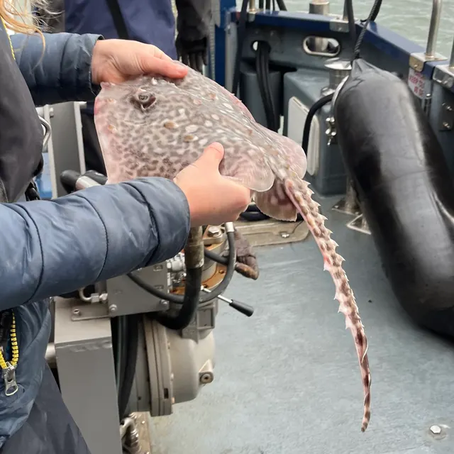 Thornback rayThe commonest European ray, covered in thorn-like bucklers, laying horny egg cases known as mermaid's purses, and requiring careful handling on release.
Ella McCausland — CC BY, via iNaturalist
Places within this area
Publicly documented fishing geography. FishingHQ describes what the ground is; it does not say whether you may fish it, and every one of these sends that question to the body that holds the answer. Browse every place in this part of the world.
Who to ask before fishing any of these
FishingHQ does not know the current access position here. Shore angling in Wales is not rod-licensed, but access rights, landowner permission, local authority and harbour byelaws, national and inshore fisheries measures, and site designations all apply and all change. Check the current position with Natural Resources Wales, the harbour or local authority, and the landowner before going.
FishingHQ does not know the current access position here. Shore angling in Wales is not rod-licensed, but access rights, landowner permission, local authority and harbour byelaws, national and inshore fisheries measures, and site designations all apply and all change. Check the current position with Natural Resources Wales, the harbour or local authority, and the landowner before going. This water is tidal and transitional, so the freshwater regime may also apply above the tidal limit: FishingHQ does not know the current access position here. Freshwater rod fishing in Wales requires a current rod licence AND separate permission from whoever controls the fishing, which is frequently a club, riparian owner or navigation authority rather than a public body. Close seasons, byelaws and local rules apply and change. Check with Natural Resources Wales and with the controlling club or owner before going.
Ramsey Sound
Tidal race · Salt water
A kilometre-wide channel between Ramsey Island and the St David's peninsula, with a reef of jagged rock fingers — the Bitches — projecting from the island side into the middle of the flow.
Open to the Irish Sea from the north and to St Bride's Bay from the south.
Particular to this ground: moving water and currents, cliffs and rock platforms, cold water shock.
Particular to this water: This ground carries conservation designations that constrain access, vehicles, bait collection and disturbance independently of any fishing rule.
St Govan's Head
Rock mark · Salt water
Vertical Carboniferous limestone cliffs of forty to fifty metres above deep water, with a chapel wedged into a cleft and a coast of stacks, arches and blowholes either side. Hard, sharp, well-fractured rock throughout.
South-facing and open to the Celtic Sea, taking Atlantic swell that has crossed the whole approach with no shelter.
Particular to this ground: cliffs and rock platforms, cliffs and rock platforms, cold water shock, fishing alone.
Severe hazards of Pembrokeshire and the south-west Wales coast apply here: moving water and currents.
Particular to this water: This ground carries conservation designations that constrain access, vehicles, bait collection and disturbance independently of any fishing rule.
Strumble Head
Headland · Salt water
A hard igneous headland projecting into the St George's Channel, with a lighthouse islet, deep water immediately off it and a strong tidal stream past the point.
Severe hazards of Pembrokeshire and the south-west Wales coast apply here: cliffs and rock platforms, moving water and currents, cold water shock.
Whitesands Bay and St David's Head
Headland · Salt water
A clean Atlantic sand bay backed by dunes with a hard igneous headland at its northern end, boulder ground beneath the head and a strong stream running out to Ramsey Sound.
Severe hazards of Pembrokeshire and the south-west Wales coast apply here: cliffs and rock platforms, moving water and currents, cold water shock.
Solva
Harbour wall · Salt water
A narrow drowned inlet with a dog-leg entrance between rock walls, drying to sand and gravel inside, on a coast of hard folded Cambrian rock. The coves and rock marks either side of the entrance are the water a resident kayak fishing guide works.
Severe hazards of Pembrokeshire and the south-west Wales coast apply here: cliffs and rock platforms, moving water and currents, cold water shock.
Broad Haven and Little Haven
Beach · Salt water
Two adjoining sand bays in St Bride's Bay, with Old Red Sandstone and Coal Measures cliffs, rock ledges at the points and clean sand between.
Severe hazards of Pembrokeshire and the south-west Wales coast apply here: cliffs and rock platforms, moving water and currents, cold water shock.
Milford Haven waterway
Estuary · Brackish water
One of the deepest natural harbours in the world: a drowned valley system with deep water carried far inland, energy terminals along both shores, and extensive mud and saltmarsh in the upper reaches.
Severe hazards of Pembrokeshire and the south-west Wales coast apply here: cliffs and rock platforms, moving water and currents, cold water shock.
Freshwater West
Beach · Salt water
The most exposed sand beach in Wales, taking Atlantic swell straight into a west-facing bay, with a strong rip system, reef at both ends and heavy surf for most of the year.
Particular to this ground: moving water and currents.
Severe hazards of Pembrokeshire and the south-west Wales coast apply here: cliffs and rock platforms, cold water shock.
Particular to this water: Part of this coast lies beside an operating military range. The authority states that Range West is never open to the general public and carries no right of way, that unscheduled firing may take place without prior warning, and that firing may be cancelled without notice. Firing times change daily, are published by the range, and are not reported here.
6 more places in this area
Stackpole Quay
Harbour wall · Salt water
A tiny stone quay cut into Carboniferous limestone, said to be the smallest harbour in Britain, with deep clear water and heavy reef ground immediately outside.
Severe hazards of Pembrokeshire and the south-west Wales coast apply here: cliffs and rock platforms, moving water and currents, cold water shock.
Tenby South Beach
Surf beach · Salt water
Two miles of clean, snag-free sand running south from the town to Giltar Point, with Caldey Island offshore and no rough ground anywhere on it. The absence of snags is the defining fact: this is a beach where light rigs and small hooks work because nothing takes them.
Open south-east, sheltered from the prevailing south-westerly by the Castle headland and Giltar.
Severe hazards of Pembrokeshire and the south-west Wales coast apply here: cliffs and rock platforms, moving water and currents, cold water shock.
Giltar Point
Headland · Salt water
The limestone point closing the south end of Tenby's beach, with rough broken ground off it and Caldey Sound running between it and the island. Snaggy enough that rotten-bottom rigs are the normal answer, which is the opposite of the sand a hundred metres north of it.
Open south and west across Caldey Sound.
Particular to this ground: cliffs and rock platforms.
Severe hazards of Pembrokeshire and the south-west Wales coast apply here: moving water and currents, cold water shock.
Hobbs Point
Jetty · Brackish water
The old slipway and jetty on the north shore of Pembroke Dock, inside the Milford Haven waterway, with deep water off the end and the tide running through. A sheltered mark on a waterway that is fishable in weather that closes the open coast.
Well sheltered inside the waterway; the Haven's topography is what makes it fishable when the coast outside is not.
Severe hazards of Pembrokeshire and the south-west Wales coast apply here: cliffs and rock platforms, moving water and currents, cold water shock.
Particular to this water: This is an owned and operated structure. Whether angling is allowed on it, when, from where and on what terms is the operator's decision, is frequently seasonal, and changes without notice.
St Brides Bay
Bay · Salt water
The wide rocky bay between St David's Head and Skomer, with broken ground and kelp round its edges and cleaner sand in the middle. A snaggy seabed, which decides everything: lures and float work here and bottom fishing costs tackle.
Open west into the Celtic Sea, with the islands taking the worst of it at the mouth.
Particular to this ground: cliffs and rock platforms.
Severe hazards of Pembrokeshire and the south-west Wales coast apply here: moving water and currents, cold water shock.
Goodwick breakwater
Breakwater · Salt water
The long breakwater sheltering Fishguard harbour, with the ferry terminal inside it and deep water on the seaward face. Structure and depth in one place on a coast where most marks are one or the other.
The breakwater exists to take the northerly weather, and the seaward face gets it.
Severe hazards of Pembrokeshire and the south-west Wales coast apply here: cliffs and rock platforms, moving water and currents, cold water shock.
Particular to this water: This is an owned and operated structure. Whether angling is allowed on it, when, from where and on what terms is the operator's decision, is frequently seasonal, and changes without notice.
Safety
Cliffs and rock platforms — Can cause serious injury or death
Atlantic swell arrives in sets and the largest wave of a set is far bigger than the preceding average. A dry ledge is filled and the backwash takes whatever is on it into deep water against a vertical, kelp-covered face with no shallow margin to recover onto.
What reduces it: Watch the sea for a full set of several minutes before committing to any position. Choose a platform with a way up behind it. Wear a buoyancy aid on the rocks, fish with somebody, and carry the means of calling for help on your person rather than in a bag.
Worse when:
- Long-period Atlantic swell, which arrives in sets far larger than the sea state suggests.
- On a rising tide, when each set reaches further up the platform than the last.
Moving water and currents — Can cause serious injury or death
Tidal streams through the sounds run faster than a kayak can paddle or a small outboard can push against, and produce standing waves, boils and overfalls on springs. A craft that enters the acceleration is committed to wherever the stream takes it.
What reduces it: Plan every movement around the state of the tide before the wind. Know when the stream turns at the specific sound rather than at a distant standard port. Do not attempt a sound on spring tides. Treat visible overfalls as a boundary and allow a wide margin, since their position moves through the tide.
Worse when:
- Spring tides, when the streams run hardest and the overfalls are largest.
- Wind against tide, which stands the race up into breaking water.
Cold water shock — Can cause serious injury or death
Atlantic water on this coast stays cold enough year round that immersion produces an involuntary gasp and loss of breathing control in the first seconds, which is what decides the outcome rather than the swim afterwards.
What reduces it: Wear a buoyancy aid, do not fish alone on exposed rock, and carry a means of calling for help on the person.
Fishing alone — Can cause injury needing treatment
Many marks are reached by long, exposed cliff paths above vertical drops, and a person injured on a remote ledge is a difficult and slow rescue with no vehicle access.
What reduces it: Tell somebody the mark and the return time, do not go alone to remote ledges, and carry a means of calling for help and a light on the person.
Check the rules before you fish
Fishing laws, bylaws, access rules, seasons, bait restrictions and permitted methods vary by location and can change. Check the current rules from the relevant authority and the water you intend to fish before fishing.
Check with:
- Current national or regional law for where you are fishing
- Current local bylaws
- The relevant fisheries authority
- The landowner, club or fishery whose water it is
- Any restrictions specific to the species or the method you intend to use
Where to go next
What swims here
- Atlantic mackerelInshore through the summer and concentrated hard by the races, where the stream stacks the small fish they are working on.
- Ballan wrasseResident in the kelp forest and boulder ground along the whole coast and around the islands, and one of the species this coast is genuinely exceptional for.
- Conger eelIn the deep gullies, boulder ground and reef of the hard-rock coast, and around wreck offshore.
- European lobsterIn the boulder, reef and gully ground of the hard-rock coast, which is the habitat the species requires. What may be taken, at what size and under what permission is a matter for the current rules and for the designations this coast carries.
- European sea bassIn and around the tidal races, headlands and reef edges through the warmer months, feeding in the fast lanes and holding in the slack beside them. The association is with the state of the stream rather than with a particular shore.
- PollackOver the kelp and gully ground where deep water comes close against hard rock, which puts a normally boat-caught fish within reach of a shore ledge on this coast.
- Thick-lipped grey mulletIn Milford Haven, the estuaries and the harbours through the warmer months, which is a quite different water from the exposed coast a few miles seaward.
- Thornback rayOver the clean sand of the bays and the sheltered ground inside the haven, rather than on the exposed reef.
How this compares
- Brittany and the French Atlantic coastTwo hard-rock Atlantic peninsulas whose fisheries are organised by tidal races around headlands and islands, and whose bass fishing is the same fishery conducted in two languages. Brittany's range is larger and its intertidal reef fishery has no Welsh equivalent.
- The Causeway and Antrim coastTwo hard-rock Atlantic-facing coasts whose fisheries and dangers are both organised by tidal races around headlands and islands. The rock differs — basalt against old sedimentary and igneous — and the practice barely does, which is a useful demonstration that ground type matters less than water speed.
- The Welsh coast and AngleseyTwo Welsh coasts separated by their rock and their tide. Anglesey and the north are their own system; Pembrokeshire is a hard-rock Atlantic peninsula with island sounds, and the races rather than the ground decide the fishing.
Environment and conservation
Sources and evidence
- Cefas science, advice and data on marine and freshwater environments — Centre for Environment, Fisheries and Aquaculture Science (Government fisheries body)Relied on for: Marine environmental science for UK shelf seas, including the physical characterisation of sediment, coastal process and the monitoring programmes that describe them.States this directlyCitation checked — the work exists and is described correctly
- ICES Advice on fishing opportunities, catch and effort — International Council for the Exploration of the Sea (Scientific institute)Relied on for: Ecoregion description, stock distribution and the hydrography of the sea areas assessed.States this directlyCitation checked — the work exists and is described correctly
- JNCC species and habitat conservation advice — Joint Nature Conservation Committee (Conservation authority)Relied on for: Designation, habitat description and conservation status of the marine, coastal and freshwater habitats named.States this directlyCitation checked — the work exists and is described correctly
- The Fishes of the British Isles and North-West Europe — Macmillan, 1969 (Reference work)Relied on for: Distribution, habitat association and biology of the fishes of the British Isles named here.States this directlyCitation checked — the work exists and is described correctly
- RNLI water safety guidance: cold water shock and Float to Live — Royal National Lifeboat Institution (Water-safety or diver-training authority)Relied on for: Cold water shock and the immersion response, tidal cut-off, and water-safety guidance for shore anglers and small-craft users.States this directlyPassage read and verified
- Met Office shipping forecast, inshore waters forecast and marine warnings — Met Office, United Kingdom (Government fisheries body)Relied on for: That inshore waters forecasts, sea state and swell are the operative inputs for shore and small-craft decisions in these waters.States this directlyCitation checked — the work exists and is described correctly
Why the 14 connections on this page are here, and the sources
What swims here
Backed by research — 8 connections
Supported by peer-reviewed research or fisheries science. The sources are listed and can be checked.
Atlantic mackerel
A claim that a place contains the ground, water and seasonal conditions the species is associated with. It is a distributional statement about the world, it rests on the regional reference literature, and it deliberately asserts nothing about access, permission or catch.
- The Fishes of the British Isles and North-West Europe — Macmillan, 1969 (Reference work)Relied on for: Distribution and habitat association of the marine, estuarine and freshwater fishes of the British Isles, including which coasts and ground types a species occupies.States this directlyCitation checked — the work exists and is described correctly
- FishBase: a global information system on fishes — Froese, R. and D. Pauly, eds. — FishBase Consortium (Scientific institute)Relied on for: Recorded distribution, depth range and habitat association for the species named.States this directlyPassage read and verified
Ballan wrasse
A claim that a place contains the ground, water and seasonal conditions the species is associated with. It is a distributional statement about the world, it rests on the regional reference literature, and it deliberately asserts nothing about access, permission or catch.
- The Fishes of the British Isles and North-West Europe — Macmillan, 1969 (Reference work)Relied on for: Distribution and habitat association of the marine, estuarine and freshwater fishes of the British Isles, including which coasts and ground types a species occupies.States this directlyCitation checked — the work exists and is described correctly
- FishBase: a global information system on fishes — Froese, R. and D. Pauly, eds. — FishBase Consortium (Scientific institute)Relied on for: Recorded distribution, depth range and habitat association for the species named.States this directlyPassage read and verified
Conger eel
A claim that a place contains the ground, water and seasonal conditions the species is associated with. It is a distributional statement about the world, it rests on the regional reference literature, and it deliberately asserts nothing about access, permission or catch.
- The Fishes of the British Isles and North-West Europe — Macmillan, 1969 (Reference work)Relied on for: Distribution and habitat association of the marine, estuarine and freshwater fishes of the British Isles, including which coasts and ground types a species occupies.States this directlyCitation checked — the work exists and is described correctly
- FishBase: a global information system on fishes — Froese, R. and D. Pauly, eds. — FishBase Consortium (Scientific institute)Relied on for: Recorded distribution, depth range and habitat association for the species named.States this directlyPassage read and verified
European lobster
A claim that a place contains the ground, water and seasonal conditions the species is associated with. It is a distributional statement about the world, it rests on the regional reference literature, and it deliberately asserts nothing about access, permission or catch.
- JNCC species and habitat conservation advice — Joint Nature Conservation Committee (Conservation authority)Relied on for: Habitat classification and description for the intertidal, coastal and freshwater habitats named, and the species characteristically associated with them.States this directlyCitation checked — the work exists and is described correctly
- Cefas science, advice and data on marine and freshwater environments — Centre for Environment, Fisheries and Aquaculture Science (Government fisheries body)Relied on for: Characterisation of UK inshore sediment, intertidal habitat and the shellfish beds associated with them.States this directlyCitation checked — the work exists and is described correctly
European sea bass
A claim that a place contains the ground, water and seasonal conditions the species is associated with. It is a distributional statement about the world, it rests on the regional reference literature, and it deliberately asserts nothing about access, permission or catch.
- The Fishes of the British Isles and North-West Europe — Macmillan, 1969 (Reference work)Relied on for: Distribution and habitat association of the marine, estuarine and freshwater fishes of the British Isles, including which coasts and ground types a species occupies.States this directlyCitation checked — the work exists and is described correctly
- FishBase: a global information system on fishes — Froese, R. and D. Pauly, eds. — FishBase Consortium (Scientific institute)Relied on for: Recorded distribution, depth range and habitat association for the species named.States this directlyPassage read and verified
Pollack
A claim that a place contains the ground, water and seasonal conditions the species is associated with. It is a distributional statement about the world, it rests on the regional reference literature, and it deliberately asserts nothing about access, permission or catch.
- The Fishes of the British Isles and North-West Europe — Macmillan, 1969 (Reference work)Relied on for: Distribution and habitat association of the marine, estuarine and freshwater fishes of the British Isles, including which coasts and ground types a species occupies.States this directlyCitation checked — the work exists and is described correctly
- FishBase: a global information system on fishes — Froese, R. and D. Pauly, eds. — FishBase Consortium (Scientific institute)Relied on for: Recorded distribution, depth range and habitat association for the species named.States this directlyPassage read and verified
Thick-lipped grey mullet
A claim that a place contains the ground, water and seasonal conditions the species is associated with. It is a distributional statement about the world, it rests on the regional reference literature, and it deliberately asserts nothing about access, permission or catch.
- The Fishes of the British Isles and North-West Europe — Macmillan, 1969 (Reference work)Relied on for: Distribution and habitat association of the marine, estuarine and freshwater fishes of the British Isles, including which coasts and ground types a species occupies.States this directlyCitation checked — the work exists and is described correctly
- FishBase: a global information system on fishes — Froese, R. and D. Pauly, eds. — FishBase Consortium (Scientific institute)Relied on for: Recorded distribution, depth range and habitat association for the species named.States this directlyPassage read and verified
Thornback ray
A claim that a place contains the ground, water and seasonal conditions the species is associated with. It is a distributional statement about the world, it rests on the regional reference literature, and it deliberately asserts nothing about access, permission or catch.
- The Fishes of the British Isles and North-West Europe — Macmillan, 1969 (Reference work)Relied on for: Distribution and habitat association of the marine, estuarine and freshwater fishes of the British Isles, including which coasts and ground types a species occupies.States this directlyCitation checked — the work exists and is described correctly
- FishBase: a global information system on fishes — Froese, R. and D. Pauly, eds. — FishBase Consortium (Scientific institute)Relied on for: Recorded distribution, depth range and habitat association for the species named.States this directlyPassage read and verified
How people fish here
What experienced anglers do — 2 connections
Widely and independently recommended by experienced anglers and specialist sources. This is real angling knowledge, not proof: controlled evidence for it is limited, and FishingHQ records it as convention rather than as a demonstrated effect.
Lure fishing
A claim about angling convention rather than about the world: that this place sits within this branch of fishing, which drives the information architecture as well as the page. It rests on independent practitioner description.
- General angling website restatements of established technique — Various (Credible secondary source)Relied on for: Widely restated descriptions of which practices are conventionally used in the waters named, recorded as practitioner consensus rather than as scholarship.Background and mechanism onlyCitation checked — the work exists and is described correctly
- Sea Angler — Bauer Media (Specialist angling publication)Relied on for: Long-running published description of British sea angling practice by region and by ground type.FishingHQ's interpretation of what it saysCitation checked — the work exists and is described correctly
Sea fishing
A claim about angling convention rather than about the world: that this place sits within this branch of fishing, which drives the information architecture as well as the page. It rests on independent practitioner description.
- General angling website restatements of established technique — Various (Credible secondary source)Relied on for: Widely restated descriptions of which practices are conventionally used in the waters named, recorded as practitioner consensus rather than as scholarship.Background and mechanism onlyCitation checked — the work exists and is described correctly
- Sea Angler — Bauer Media (Specialist angling publication)Relied on for: Long-running published description of British sea angling practice by region and by ground type.FishingHQ's interpretation of what it saysCitation checked — the work exists and is described correctly
How this compares
What experienced anglers do — 3 connections
Widely and independently recommended by experienced anglers and specialist sources. This is real angling knowledge, not proof: controlled evidence for it is limited, and FishingHQ records it as convention rather than as a demonstrated effect.
Brittany and the French Atlantic coast
A claim that two places are worth reading against one another, because a reader choosing between them or generalising from one to the other needs to know how the underlying process differs.
- General angling website restatements of established technique — Various (Credible secondary source)Relied on for: Widely restated descriptions of which practices are conventionally used in the waters named, recorded as practitioner consensus rather than as scholarship.Background and mechanism onlyCitation checked — the work exists and is described correctly
- Sea Angler — Bauer Media (Specialist angling publication)Relied on for: Long-running published description of European sea angling practice by region and by ground type.FishingHQ's interpretation of what it saysCitation checked — the work exists and is described correctly
The Causeway and Antrim coast
A claim that two places are worth reading against one another, because a reader choosing between them or generalising from one to the other needs to know how the underlying process differs.
- General angling website restatements of established technique — Various (Credible secondary source)Relied on for: Widely restated descriptions of which practices are conventionally used in the waters named, recorded as practitioner consensus rather than as scholarship.Background and mechanism onlyCitation checked — the work exists and is described correctly
- Sea Angler — Bauer Media (Specialist angling publication)Relied on for: Long-running published description of British and Irish sea angling practice by region and by ground type.FishingHQ's interpretation of what it saysCitation checked — the work exists and is described correctly
The Welsh coast and Anglesey
A claim that two places are worth reading against one another, because a reader choosing between them or generalising from one to the other needs to know how the underlying process differs.
- General angling website restatements of established technique — Various (Credible secondary source)Relied on for: Widely restated descriptions of which practices are conventionally used in the waters named, recorded as practitioner consensus rather than as scholarship.Background and mechanism onlyCitation checked — the work exists and is described correctly
- Sea Angler — Bauer Media (Specialist angling publication)Relied on for: Long-running published description of British sea angling practice by region and by ground type.FishingHQ's interpretation of what it saysCitation checked — the work exists and is described correctly
Environment and conservation
Backed by research — 1 connection
Supported by peer-reviewed research or fisheries science. The sources are listed and can be checked.
Marine protected areas and spearfishing
A claim that a place raises a particular environmental question, resting on the scientific and conservation literature for the system rather than on angling practice.
- JNCC species and habitat conservation advice — Joint Nature Conservation Committee (Conservation authority)Relied on for: Habitat classification and description for the intertidal, coastal and freshwater habitats named, and the species characteristically associated with them.States this directlyCitation checked — the work exists and is described correctly
- Cefas science, advice and data on marine and freshwater environments — Centre for Environment, Fisheries and Aquaculture Science (Government fisheries body)Relied on for: Characterisation of UK inshore sediment, intertidal habitat and the shellfish beds associated with them.States this directlyCitation checked — the work exists and is described correctly
How FishingHQ labels evidence is explained in the evidence policy.