Brittany and the French Atlantic coast
Fishing regions · Last reviewed 2026-08-16
A granite peninsula thrown out into the Atlantic between the Channel and Biscay, carrying the largest tidal ranges in Europe, ferocious races around its headlands and islands, and the continental heartland of bass fishing.
Safety: tides and being cut off — can cause serious injury or death. 3 more points apply here.
Contamination and toxins in the catch — Can cause injury needing treatment
Bivalves gathered on the reef filter the water they sit in and concentrate marine biotoxins and microbiological contamination, and neither cooking nor appearance removes a biotoxin.
What reduces it: Check the current harvesting area classification and closures with the local food-safety authority, and note that this is a different framework from the size and quantity rules set by prefectural order.
Being listed here is not permission to fish. What that meansClose
Access, fishing rights, seasons, licences, local bylaws and permitted methods vary and can change. Check current access, permission, local regulations, closures and restrictions before you travel or fish. FishingHQ describes what the ground is and names who holds the answer; it does not hold the answer itself.
Find the authority for a jurisdiction · What FishingHQ does and does not cover
Brittany is a coast-tier record because the peninsula is a single physical proposition: hard old rock pushed out into the Atlantic, with an enormous tidal range washing back and forth across it four times a day.
THE TIDAL RANGE IS THE FIRST FACT AND IT IS THE LARGEST IN EUROPE. On the northern Breton coast and into the bay at its eastern end, spring ranges exceed anything in Britain and are among the biggest in the world. That governs everything: the extent of ground that uncovers, the speed of the streams that move that volume, the timing of every session, and the existence of a tidal power station built on it.
THE ROCK IS OLD AND HARD. Granite and metamorphic rock give a coast of headland, reef, islet, boulder field and deeply indented bay, with kelp everywhere the ground is hard and clean sand in the embayments between. There is a great deal of intertidal reef — ground that is sea at high water and a boulder field at low — which is the characteristic Breton shore.
THE RACES ARE THE SECOND MAJOR FEATURE. Where a very large tidal exchange meets a headland, an island or a narrow sound, the stream accelerates violently. Several of the passages off this coast run at speeds among the fastest in Europe, produce overfalls and standing waves, and are navigational features of long-standing seriousness.
IT IS THE CONTINENTAL HEARTLAND OF BASS FISHING and that is not a marketing claim. The combination of rock, race, kelp and enormous water movement is close to an optimal bass specification, and a very large body of European lure-fishing technique was developed here and exported. The fishery has also been at the centre of the European argument about bass stock management.
THE OTHER FISHERIES ARE SUBSTANTIAL. Pollack and wrasse over the reef. Conger in the boulder. Rays and flatfish over the clean sand of the bays. Mackerel and pelagic species in the races in season. And a shore-gathering tradition — la pêche à pied — that is a genuine mass activity here rather than a specialist one, with its own regulation and its own casualty record.
AND THE ISLANDS OFF THE END are their own proposition: rock, deep water, tide, and a fishing culture built on a working sea.
What fishing here is like
A hard granite and metamorphic peninsula projecting into the Atlantic between the Channel and the Bay of Biscay, deeply indented with headlands, reefs, islets, boulder fields and clean sand embayments, with extensive kelp on the hard ground. Tidal range is the largest in Europe, reaching extreme values on the northern coast, so vast areas of intertidal reef and sand uncover and cover twice a day and the streams that move that volume run very hard past every headland and through every sound. Water is Atlantic, cool, and clearer than the Channel to the east. Exposure to Atlantic swell is direct on the western and northern coasts.
What you can target here
One entry per fish, grouped by how you would be fishing — because the answer is a different one from the rocks and from a boat. Each entry says how strongly the sources support it and how much evidence sits behind it. These are documented catches, not a forecast, and none of it is a statement that you may fish any particular ground.
From the shore · 11
 European sea bassCharacteristic of this water4 placesPointe du Raz, The Golfe du Morbihan, The Côte Sauvage, Quiberon, The Baie de DouarnenezOver bay, headland, rock mark, tidal channelAround Apr–Nov
 PollackRegular local target3 placesPointe du Raz, The Baie de Douarnenez, The Côte Sauvage, QuiberonOver bay, headland, rock mark
 Ballan wrasseRegular local target2 placesPointe du Raz, The Côte Sauvage, QuiberonOver headland, rock mark
 Thick-lipped grey mulletRegular local target2 placesThe Baie de Douarnenez, The Golfe du MorbihanOver bay, tidal channel
 European flounderRegular local target1 placeThe Golfe du MorbihanOver tidal channel
 Atlantic mackerelSeasonal3 placesPointe du Raz, The Côte Sauvage, Quiberon, The Baie de DouarnenezOver bay, headland, rock markAround Jun–Sept
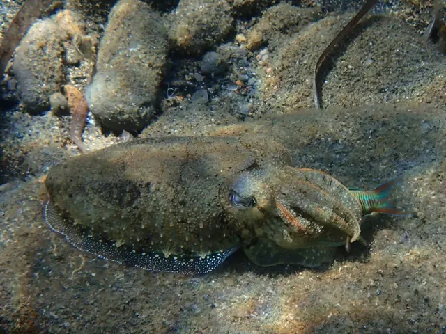
Also documented from the shore: Common cuttlefish · European squid · Common octopus · Conger eel · Native oyster
From a boat · 2
What these strengths mean
- Characteristic of this water
- This water is strongly identified with this species by the sources that cover it.
- Regular local target
- Fishing sources describe this as a normal local target here, not merely as caught.
- Seasonal
- Well supported, and concentrated in part of the year rather than spread through it.
- Recorded here
- At least one credible public account of this species being caught here. That is all it means.
- How breadth is counted
- A fish documented at six marks is shown as six marks: breadth never raises the strength on its own. A fishery account describes the fishing; a recorded catch reports one specific catch. How evidence is weighed.
How people fish here
6 methods are recorded on the places documented here, counted from the records themselves rather than from what is practised in the country. Each opens a full guide to the technique.
Spinning
Recorded at 4 places here, over bay, headland, rock mark, tidal channel.
Casting an artificial lure and retrieving it so that it moves like something alive — the most direct form of lure fishing.
Documented on the same ground: European sea bass, Ballan wrasse, European flounder, Pollack, Thick-lipped grey mullet, Atlantic mackerel.
Float fishing
Recorded at 3 places here, over bay, headland, rock mark.
Suspending a bait at a controlled depth beneath a buoyant indicator — the most visual, most controllable and most widely applicable method in angling.
Documented on the same ground: European sea bass, Ballan wrasse, Pollack, Thick-lipped grey mullet, Atlantic mackerel, European squid.
Eging
Recorded at 2 places here, over bay, tidal channel.
Jigging for squid and cuttlefish with a barbed, weighted lure worked in lifts and pauses — a Japanese discipline with its own tackle, vocabulary and competitive scene.
Documented on the same ground: European sea bass, European flounder, Pollack, Thick-lipped grey mullet, Common cuttlefish, European squid.
Kayak fishing
Recorded at 2 places here, over bay, tidal channel.
A platform rather than a technique: quiet, shallow-draught access to water no other craft reaches, bought at the price of exposure, and a discipline where the decision not to launch is part of the skill.
Documented on the same ground: European sea bass, European flounder, Pollack, Thick-lipped grey mullet, Common cuttlefish, European squid.
Ledgering
Recorded at 1 place here, over tidal channel.
Fishing a bait on the bottom held by a weight, with no float — the simplest way to fish at distance, in depth, or in wind.
Documented on the same ground: European sea bass, European flounder, Thick-lipped grey mullet, Common cuttlefish, Native oyster.
Shore diving
Recorded at 1 place here, over rock mark.
Entering and leaving the water from land under your own power — the most accessible spearfishing and the one where the entry and exit are the dangerous part.
Documented on the same ground: European sea bass, Ballan wrasse, Pollack, Atlantic mackerel, Common octopus.
These are the methods documented at the places FishingHQ holds here. A species listed beside a method is documented on the same ground, which is not the same as being taken that way — where a source establishes the method a fish was caught on, it is stated on that place’s own page. All fishing methods.
The fishing year here
The months the records under this area actually name, tightest season first. This is “observed in these months” rather than a season: a species whose months nobody recorded is not listed, because a gap in the evidence is not a year-round fishery.
- Atlantic mackerelJune to September
- Common cuttlefishMarch to June
- European squidSeptember to December
- European sea bassApril to November
What dominates
Lure fishing for bass from rock, reef and boat, which this coast is internationally known for and which is organised entirely around the state of the tide. Shore fishing over intertidal reef and boulder for pollack, wrasse and conger, with expendable terminal tackle. Clean-ground beach fishing in the embayments for ray, flatfish and bass. Small-boat and charter fishing around the reefs, races and islands. La pêche à pied — shore gathering of shellfish and crustaceans on the enormous low-water reef — which is a mass regional activity with its own rules and its own casualty record. Kayak fishing in sheltered water, with the races absolutely excluded on a running tide.
The water available
Hard granite and metamorphic headland, reef and islet with extensive kelp; enormous intertidal boulder and reef fields exposed by extreme tidal range; clean sand embayments and long beaches; violent tidal races and overfalls at the headlands and in the sounds; a large shallow tidal gulf with islands and strong internal streams; estuaries and rias cutting well inland; and offshore reef, bank and wreck ground on the Atlantic approaches.
How the rules are structured
France's framework differs from Britain's in ways that matter. Recreational sea fishing from the shore or from a boat requires no general licence, but it is subject to national and European conservation measures including minimum sizes, bag limits and — for bass in particular — measures that have changed repeatedly and have differed between the areas north and south of a defined line. Recreational catches of certain species must be marked in a prescribed way before landing. Freshwater fishing requires a licence and membership of an approved association, which is a completely different arrangement from the sea. Shore gathering is separately and specifically regulated with size limits, quantity limits, permitted tools and seasonal or area closures, and it is enforced. Shellfish harvesting areas are classified for food safety and closed on monitoring. Substantial parts of this coast carry conservation designation. FishingHQ does not state what any current rule is.
Who to ask
- The French maritime affairs administration for the department, which enforces recreational sea fishing measures, size limits and shore-gathering rules.
- The regional prefecture, whose orders set local shore-gathering rules, closures and permitted tools, and which differ between departments.
- The departmental federation for freshwater fishing, membership of which is required alongside a licence for river and lake fishing.
- The relevant protected-area or marine park authority, where a designation affects access, collection or activity.
- The local food-safety authority, for shellfish harvesting area classification and closures.
Words you will meet
- La pêche à pied
- Fishing on foot: gathering shellfish, crustaceans and other species from the exposed low-water reef and sand. On this coast it is a mass regional activity practised by families rather than a specialist pursuit, and it is specifically regulated on size, quantity, tools and season.
- Estran
- The intertidal zone — the ground between high and low water. On a coast with the largest tidal range in Europe the estran is vast, and the word does a great deal of work locally because so much of the fishing and gathering happens on ground that is only briefly land.
- Raz
- A tidal race. The named raz of this coast are among the fastest streams in Europe, they produce overfalls and standing waves on the tide, and they are navigational features of long-standing seriousness rather than local colour.
- Coefficient
- The French tidal coefficient, a number from about 20 to 120 describing the size of a given tide. It is published with every prediction and it is how everybody here talks about the tide: a big coefficient means a big range, big streams and a great deal of uncovered ground.
Conditions and hazards
The extreme tidal range is the governing hazard and it produces two separate mechanisms. On the vast low-water reef, the flood returns across broken ground faster than a person can pick their way over it, and it fills the channels and gullies between the rocks first — so water appears behind gatherers and anglers who are watching the sea in front of them, and the ground itself is slippery, weeded and full of holes. This is the specific mechanism behind the casualty record of la pêche à pied, which is significant. Afloat, the races run faster than a small craft can make ground against, produce overfalls and standing waves, and are made dramatically worse by wind against stream. Ashore on the exposed western and northern coasts, Atlantic swell arrives in sets independently of local wind onto rock with deep water in front and no shallow margin. Water is cold enough year-round for cold water shock to decide an immersion. And the shellfish carry a food-safety hazard entirely separate from the walk out.
The biggest tides in Europe, and what a coefficient of 110 actually means
Everything distinctive about fishing Brittany follows from one number, and the local habit of talking about that number rather than about the weather is the clearest sign of it.
THE RANGE IS EXTREME. Spring tidal ranges on the northern Breton coast and into the bay at its eastern end are the largest in Europe and among the largest anywhere. The physical reason is resonance: the shape and depth of the Channel and its approaches happen to amplify the tidal wave as it travels up, and this coast sits where that amplification is greatest. It is the same mechanism that gives the Severn and the Bay of Fundy their ranges, in a different basin.
THE COEFFICIENT IS HOW EVERYBODY HERE DISCUSSES IT. French tidal predictions carry a coefficient — a number from roughly 20 to 120 describing the size of that particular tide — and it is published with every forecast. A coefficient of 40 is a small neap; 95 is a big spring; 110 and above is very large indeed. Anglers, gatherers, boat crews and divers plan by it, and a visitor who learns to read it has learned the local language.
WHAT A BIG COEFFICIENT DOES, IN ORDER. It uncovers an enormous area of reef and sand that is normally sea — which is why the shore gathering here is a mass activity and why marks exist that are reachable a handful of times a year. It makes the streams run much harder, because the same six hours must move far more water, which turns every headland and sound into a race. It shortens the window at any given mark. And it makes the return across the reef faster and less forgiving.
WHICH MEANS THE SESSION IS PLANNED AROUND THE TIDE AND NOT THE CLOCK. A Breton bass angler is reading a coefficient and a stream table, deciding which headland works on which part of which tide, and arriving for a window that may be ninety minutes long. That is the reverse of the dawn-and-dusk habit most visiting anglers bring, and it is the correct response to this water.
THE BASS FISHING FOLLOWS DIRECTLY. Bass exploit turbulence: a race concentrates and disorients prey and the fish sit where the water does the work. A coast with the largest tidal range in Europe, thrown out into the Atlantic, covered in reef and kelp and studded with headlands and sounds, produces more of that turbulence than almost anywhere. It is why the continental heart of lure fishing for bass is here, and why so much of the technique used across northern Europe was developed on this coast and exported.
AND THE TIDAL POWER STATION IS THE OUTSIDE VERIFICATION. A barrage was built on this coast to generate electricity from that range, and it has run for decades. When an engineering project of that scale is justified by a tidal range, the range is not a local boast.
Backed by research — why, and the sources (4)
Supported by peer-reviewed research or fisheries science. The sources are listed and can be checked.
- ICES Advice on fishing opportunities, catch and effort — International Council for the Exploration of the Sea (Scientific institute)Relied on for: Ecoregion description, stock distribution, nursery function and the hydrography of the European sea areas assessed.States this directlyCitation checked — the work exists and is described correctly
- Cefas science, advice and data on marine and freshwater environments — Centre for Environment, Fisheries and Aquaculture Science (Government fisheries body)Relied on for: Marine environmental science for north-west European shelf seas, including tidal range and stream, sediment characterisation, estuarine and intertidal process.States this directlyCitation checked — the work exists and is described correctly
- Sea Angler — Bauer Media (Specialist angling publication)Relied on for: Long-running published description of European sea angling practice by region and by ground type.FishingHQ's interpretation of what it saysCitation checked — the work exists and is described correctly
- General angling website restatements of established technique — Various (Credible secondary source)Relied on for: Widely restated descriptions of which practices are conventionally used in the waters named, recorded as practitioner consensus rather than as scholarship.Background and mechanism onlyCitation checked — the work exists and is described correctly
La pêche à pied: a mass activity with rules and a casualty record
Shore gathering in Brittany is not a niche pursuit practised by a few specialists. It is a mass regional activity, done by families, on a scale that has no British equivalent — and it is regulated and dangerous in proportion.
WHAT THE EXTREME RANGE MAKES POSSIBLE. On a big coefficient, kilometres of reef, boulder and sand that are normally under several metres of water become dry ground for a couple of hours. That exposes ground that is otherwise inaccessible: mussels, clams, cockles, razor clams, winkles, limpets, crabs, prawns, and — the prize — lobster and spider crab in the gullies and under the boulders.
SO THE BIG TIDES ARE SOCIAL EVENTS. The largest coefficients of the year draw very large numbers of people onto the reef, and the practice has its own equipment, its own vocabulary, its own family transmission of knowledge about which ground holds what, and its own etiquette.
AND IT IS SPECIFICALLY REGULATED, more so than most British shore gathering. Minimum sizes for each species. Quantity limits per person per tide. Rules about which tools may be used — hooks, rakes and levers are restricted because of the damage they do to the ground. Prohibitions on turning boulders and leaving them turned, which kills the community underneath. Seasonal and area closures. And the rules are set by prefectural order at department level, so they differ along the coast and they change.
THE DAMAGE QUESTION IS TAKEN SERIOUSLY HERE. An intertidal boulder field is a habitat whose value is entirely in the undersides and gaps, and a boulder left upside down is a small ecosystem destroyed. The instruction to put every rock back the way it was found is a genuine conservation measure rather than tidiness, and it is the single most important thing a gatherer does.
THE CASUALTY RECORD IS REAL AND IT IS WORTH STATING PLAINLY. People are cut off and drowned on this ground, and the mechanism is always the same: the flood returns across broken reef faster than anybody can pick their way back over it, filling the gullies and channels between the rocks first, so the water is behind them before it is in front. Add slippery weeded rock, holes between boulders, poor light at the end of the tide, and a person carrying a full bag, and the picture is complete.
WHICH IS WHY THE LOCAL PRACTICE IS SPECIFIC. Go out on the ebb rather than at low water, so the tide is still falling when you commit. Fix a leaving time from the tide, not from the bag. Know the route back and walk it in daylight. Watch the gullies behind rather than the sea in front. And do not go alone.
AND THE FOOD-SAFETY FRAMEWORK IS SEPARATE FROM THE FISHERY ONE. Bivalves filter what they sit in; harvesting areas are classified and closed on biotoxin and microbiological monitoring; and neither cooking nor appearance removes a biotoxin. That is a different authority answering a different question, and satisfying the size limits says nothing about it.
Official guidance — why, and the sources (3)
Stated by a fisheries authority, scientific institute or recognised angling body. Authoritative, but summarising rather than demonstrating.
- Shellfish classification — Food Standards Agency, 2026 (Government fisheries body)Relied on for: That shellfish harvesting areas are classified, that the classification governs what may be taken and how it must be treated, and that it is set and revised by the authority on monitoring results rather than fixed.States this directlyCitation checked — the work exists and is described correctly
- Fishers' Craft and Lettered Art: Tracts on Fishing from the End of the Middle Ages — University of Toronto Press, 1997 (Scientific literature)Relied on for: That fishing traditions develop around the water and fish available to them, and the historical method of reading such traditions.Background and mechanism onlyCitation checked — the work exists and is described correctly
- General angling website restatements of established technique — Various (Credible secondary source)Relied on for: Widely restated descriptions of regional angling practice, recorded as practitioner consensus rather than as scholarship.Background and mechanism onlyCitation checked — the work exists and is described correctly
A reef that fills from behind, and races nothing can motor against
Brittany's hazards are all expressions of the same fact — an enormous volume of water moving four times a day across hard broken ground — and they take three distinct forms.
THE FIRST IS THE RETURN ACROSS THE REEF, and it is the one that kills most people here. On a big tide, kilometres of boulder and reef uncover, and the walk out at low water is easy and interesting. The walk back is over the same ground with water rising through it, and the flood does not advance as a line — it fills the gullies and channels between the rocks first and spreads outward from them. So the sea is behind and beside a person before it is in front, and by the time it is obvious, the low ground on the route back is already a channel.
AND THE GROUND ITSELF SLOWS YOU DOWN. Wet kelp offers effectively no grip. Boulder fields are full of holes that take an ankle. Somebody carrying a full bag over that, in failing light, moves at a fraction of walking pace. The arithmetic of the tide does not adjust for that.
WHAT ADDRESSES IT. Go out while the tide is still ebbing rather than at dead low, so the falling water is a margin rather than a deadline. Fix the leaving time from the tide table and the coefficient before starting, and leave then regardless of what is in the bag. Walk the route back in daylight before committing to the far ground. Watch the gullies behind you, not the sea in front. Do not go alone, and tell somebody the plan and the return time.
THE SECOND IS THE RACES, AND THEY ARE A MATTER OF SPEED RATHER THAN SKILL. The named raz of this coast run faster than a small craft can make ground against — that is an arithmetic statement about a boat's maximum speed rather than a description of difficult conditions. A craft that enters the acceleration goes where the water goes, into overfalls and standing waves. The mistake is almost always made on the approach, because from up-tide the water looks manageable.
SO THE PLANNING ORDER IS TIDE BEFORE WIND. Use the local stream table for the specific race rather than a distant standard port, plan the return as carefully as the outward passage, do not attempt a race on a large coefficient, and never enter with wind against stream — which stands the whole thing up into steep breaking water out of all proportion to the wind.
THE THIRD IS SWELL ON THE EXPOSED COASTS. The western and northern shores take Atlantic ground swell that arrives independently of local wind, in sets, onto rock with deep water in front of it and no shallow margin to recover onto. Watch a mark through several full set cycles before committing, choose a position with a way up behind it, wear a buoyancy aid on the rocks, and do not fish exposed rock alone.
COLD WATER RUNS UNDER ALL THREE. Atlantic water here is cold enough year-round that the first seconds of an immersion decide the outcome rather than any swimming afterwards. Check the coefficient, the stream table and the swell forecast before going — all three are published and all three change.
Official guidance — why, and the sources (4)
Stated by a fisheries authority, scientific institute or recognised angling body. Authoritative, but summarising rather than demonstrating.
- RNLI water safety guidance: cold water shock and Float to Live — Royal National Lifeboat Institution (Water-safety or diver-training authority)Relied on for: Cold water shock and the immersion response, tidal cut-off, and water-safety guidance for shore anglers and small-craft users.States this directlyPassage read and verified
- Met Office shipping forecast, inshore waters forecast and marine warnings — Met Office, United Kingdom (Government fisheries body)Relied on for: That inshore waters forecasts, sea state and swell are the operative inputs for shore and small-craft decisions in north-west European waters.States this directlyCitation checked — the work exists and is described correctly
- Rock fishing safety and the declared lifejacket areas of New South Wales — NSW Department of Primary Industries and Surf Life Saving NSW (Water-safety or diver-training authority)Relied on for: Rock-platform fishing hazards, the mechanism by which anglers are swept from platforms by sets rather than by average conditions, and the measures that address it.States this directlyCitation checked — the work exists and is described correctly
- RNLI water safety guidance: cold water shock and Float to Live — Royal National Lifeboat Institution (Water-safety or diver-training authority)Relied on for: Cold water shock, immersion response and the advice to carry a means of calling for help on the person.States this directlyPassage read and verified
Some of what lives here
Fish recorded here that FishingHQ holds a reviewed photograph of. It is not a complete list of what Brittany and the French Atlantic coast holds, and it is not a prediction that you will catch any of them — it is a way in to the ones we can show you.
- European sea bassA fast, predatory inshore fish that hunts in broken water and surf, and one of the most closely managed recreational species in European seas.
Julien Renoult — CC BY 4.0, via Wikimedia Commons
- PollackA fast gadoid that hunts up off reefs and wrecks and takes a lure on the drop — and the sea fish most likely to convert a bait angler to lure fishing.
Wilhelm Thomas Fiege — CC BY-SA 4.0, via Wikimedia Commons
- Ballan wrasseA long-lived rocky-ground resident that begins life female and may change sex — and the species that turned rock marks into a lure fishery.
Diego Delso — CC BY-SA 4.0, via Wikimedia Commons
 Conger eelA very large scaleless eel of wrecks, rock and harbour walls, reaching three metres, and among the most powerful and most genuinely dangerous fish to handle in European seas.
Holger Krisp — CC BY 3.0, via Wikimedia Commons
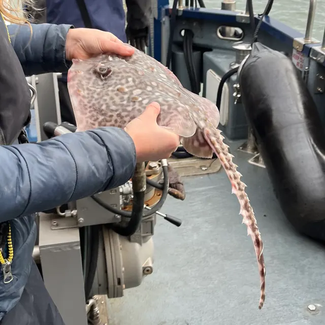 Thornback rayThe commonest European ray, covered in thorn-like bucklers, laying horny egg cases known as mermaid's purses, and requiring careful handling on release.
Ella McCausland — CC BY, via iNaturalist
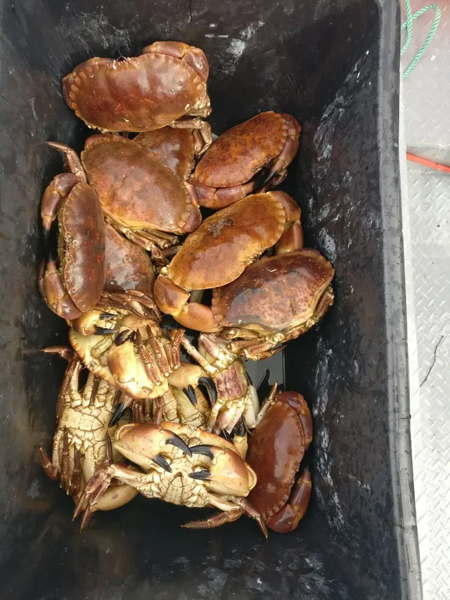 Edible crabThe large pie-crust crab of Atlantic Europe: slow-growing, long-lived, heavily regulated, and the animal most people mean when they say they went crabbing and caught something worth keeping.
Wouter Koch — CC0, via iNaturalist
Places within this area
Publicly documented fishing geography. FishingHQ describes what the ground is; it does not say whether you may fish it, and every one of these sends that question to the body that holds the answer. Browse every place in this part of the world.
Who to ask before fishing any of these
FishingHQ does not know the current access position here. Recreational sea fishing in France is not generally licensed for shore angling, but national and European measures on species, sizes, quantities and gear apply, some species carry a declaration or marking requirement, and access to structures, beaches and shellfish grounds is governed locally. All of it changes. Check the current position with the maritime prefecture or the departmental directorate for the sea, and with the commune, before going.
FishingHQ does not know the current access position here. Recreational sea fishing in France is not generally licensed for shore angling, but national and European measures on species, sizes, quantities and gear apply, some species carry a declaration or marking requirement, and access to structures, beaches and shellfish grounds is governed locally. All of it changes. Check the current position with the maritime prefecture or the departmental directorate for the sea, and with the commune, before going. This water is tidal and transitional, so the freshwater regime may also apply above the tidal limit: FishingHQ does not know the current access position here. Inland fishing in France runs through membership: an angler joins an approved local fishing association, which is affiliated to a departmental federation, and pays the national levy alongside it — so the permission and the licence arrive together and are bought from the association rather than from a state counter. Waters, seasons, methods and reciprocity arrangements differ by department and change. Check with the departmental fishing federation and the local association before going.
Pointe du Raz
Headland · Salt water
A granite headland at the western tip of Brittany ending in a jagged spine of rock running out towards the Île de Sein, with deep water immediately off it and a reef-strewn channel between.
Fully exposed to the Atlantic with no shelter in any seaward direction, and among the most consistently rough positions on the French coast.
Particular to this ground: cliffs and rock platforms, moving water and currents.
Severe hazards of Brittany and the French Atlantic coast apply here: tides and being cut off.
The Baie de Douarnenez
Bay · Salt water
A wide bay between two granite peninsulas in western Brittany, with sand beaches at its head, rock and reef along both flanks and a sheltered fishing port with substantial quay walls.
Open to the west but with both peninsulas breaking the worst of the swell, so it is fishable when the outer headlands are not.
Severe hazards of Brittany and the French Atlantic coast apply here: tides and being cut off, moving water and currents, cliffs and rock platforms.
Particular to this water: This is an owned and operated structure. Whether angling is allowed on it, when, from where and on what terms is the operator's decision, is frequently seasonal, and changes without notice.
The Golfe du Morbihan
Tidal channel · Brackish water
An almost enclosed inland sea in southern Brittany scattered with several dozen islands, entered through a single narrow gap, with mud and sand flats, oyster beds, weed and deep scoured channels between the islands.
Almost entirely sheltered from swell by its own entrance, which is why every hazard here is tidal rather than meteorological.
Particular to this ground: tides and being cut off.
Severe hazards of Brittany and the French Atlantic coast apply here: moving water and currents, cliffs and rock platforms.
Particular to this water: Shellfish harvesting areas are classified for food safety and are opened and closed on monitoring results a gatherer cannot see. Neither cooking nor appearance removes a biotoxin. Check the current classification with the responsible authority before taking anything. This ground lies in or beside a marine protected area whose zoning constrains fishing, diving, anchoring and collection independently of any licence, with rules that differ between zones and boundaries that are not visible from the water.
The Côte Sauvage, Quiberon
Rock mark · Salt water
The Atlantic-facing side of the Quiberon peninsula: a continuous line of low granite cliff, ledge, stack and small cove, taking swell directly, with deep water and reef close in and no shelter along its length.
Fully exposed to Atlantic swell along its whole length, and the standing local warning is that it is not a coast to be on the rocks of in a sea.
Particular to this ground: cliffs and rock platforms, cold water shock.
Severe hazards of Brittany and the French Atlantic coast apply here: tides and being cut off, moving water and currents.
Particular to this water: Underwater fishing is licensed and regulated separately from rod fishing throughout this jurisdiction, with its own age, equipment and distance requirements, and holding a rod licence is not permission to spearfish.
Safety
Contamination and toxins in the catch is set out at the top of this page, where it cannot be missed.
Tides and being cut off — Can cause serious injury or death
On the largest tidal range in Europe, kilometres of reef and boulder uncover and then flood from the gullies outward, so water is behind and beside a person before it is in front. Wet kelp and holes between boulders slow the return to a fraction of walking pace.
What reduces it: Go out while the tide is still ebbing rather than at dead low, fix the leaving time from the tide table and coefficient before starting, walk the route back in daylight, watch the gullies behind rather than the sea in front, and do not go alone.
Worse when:
- On a large tidal coefficient, when the most ground uncovers and the flood returns fastest.
- In failing light at the end of a tide, when the route back cannot be read.
Moving water and currents — Can cause serious injury or death
The tidal races off the headlands and through the sounds run faster than a small craft can make ground against, producing overfalls and standing waves. A craft that enters the acceleration goes where the water goes, and the mistake is made on the approach.
What reduces it: Use the local stream table for the specific race rather than a distant standard port, plan the return as carefully as the outward passage, do not attempt a race on a large coefficient, and never enter with wind against stream.
Cliffs and rock platforms — Can cause serious injury or death
The exposed western and northern coasts take Atlantic ground swell that arrives independently of local wind and in sets, onto rock with deep water in front and no shallow margin to recover onto.
What reduces it: Read the swell forecast including period rather than the wind forecast, watch a mark through several full set cycles before committing, choose a position with a way up behind it, and wear a buoyancy aid on the rocks.
Further safety reading
- Tides and being cut off — On the largest tidal range in Europe, kilometres of reef uncover and then flood from the gullies outward, while wet kelp and holes between boulders reduce the return to a fraction of walking pace.
Check the rules before you fish
Fishing laws, bylaws, access rules, seasons, bait restrictions and permitted methods vary by location and can change. Check the current rules from the relevant authority and the water you intend to fish before fishing.
Check with:
- Current national or regional law for where you are fishing
- Current local bylaws
- The relevant fisheries authority
- The landowner, club or fishery whose water it is
- Any restrictions specific to the species or the method you intend to use
Where to go next
What swims here
- Ballan wrasseOn the extensive intertidal and subtidal reef and boulder, which the extreme tidal range exposes and covers twice a day and which supplies the holes and hard-shelled food the species needs.
- Conger eelIn the deep gullies and beneath the boulder of the reef ground and around the harbour structures, holding to a lair over long periods.
- Edible crabUnder boulder and in reef gullies across the enormous intertidal, and one of the principal targets of la pêche à pied — which is regulated on size, quantity and tools precisely because the activity is a mass one here.
- European lobsterIn the interstices of the vast intertidal and subtidal boulder and reef, which the extreme tidal range makes accessible on foot on the largest coefficients and which supports both a commercial creel fishery and the regulated shore-gathering tradition.
- European sea bassThe continental heartland of the fishery. Rock, race, kelp and the largest tidal range in Europe produce more of the turbulence bass exploit than almost anywhere, and a very large body of European lure technique was developed on this coast and exported.
- PollackOver the kelp edges, reef and boulder ground of the headlands and islands, where deep water lies close in and the tidal stream delivers food past a fish holding in the slack.
- Thornback rayOver the clean sand of the embayments and the ground adjacent to the reefs, which is the counterweight fishery to the rock and is worked with entirely different tackle.
How this compares
Environment and conservation
Sources and evidence
- ICES Advice on fishing opportunities, catch and effort — International Council for the Exploration of the Sea (Scientific institute)Relied on for: Ecoregion description, stock distribution, nursery function and the hydrography of the European sea areas assessed.States this directlyCitation checked — the work exists and is described correctly
- Cefas science, advice and data on marine and freshwater environments — Centre for Environment, Fisheries and Aquaculture Science (Government fisheries body)Relied on for: Marine environmental science for north-west European shelf seas, including tidal range and stream, sediment characterisation, estuarine and intertidal process.States this directlyCitation checked — the work exists and is described correctly
- JNCC species and habitat conservation advice — Joint Nature Conservation Committee (Conservation authority)Relied on for: Designation, habitat description and conservation status of the marine, coastal and freshwater habitats named, and the species characteristically associated with them.States this directlyCitation checked — the work exists and is described correctly
- FishBase: a global information system on fishes — Froese, R. and D. Pauly, eds. — FishBase Consortium (Scientific institute)Relied on for: Recorded distribution, depth range, habitat association and biology of the species named.States this directlyPassage read and verified
- RNLI water safety guidance: cold water shock and Float to Live — Royal National Lifeboat Institution (Water-safety or diver-training authority)Relied on for: Cold water shock and the immersion response, tidal cut-off, and water-safety guidance for shore anglers and small-craft users.States this directlyPassage read and verified
- Met Office shipping forecast, inshore waters forecast and marine warnings — Met Office, United Kingdom (Government fisheries body)Relied on for: That inshore waters forecasts, sea state and swell are the operative inputs for shore and small-craft decisions in north-west European waters.States this directlyCitation checked — the work exists and is described correctly
Why the 12 connections on this page are here, and the sources
What swims here
Backed by research — 7 connections
Supported by peer-reviewed research or fisheries science. The sources are listed and can be checked.
Ballan wrasse
A claim that a place contains the ground, water and seasonal conditions the species is associated with. It is a distributional statement about the world, it rests on the regional reference literature, and it deliberately asserts nothing about access, permission or catch.
- FishBase: a global information system on fishes — Froese, R. and D. Pauly, eds. — FishBase Consortium (Scientific institute)Relied on for: Recorded distribution, depth range and habitat association for the species named.States this directlyPassage read and verified
- The Fishes of the British Isles and North-West Europe — Macmillan, 1969 (Reference work)Relied on for: Distribution and habitat association of the fishes of north-west Europe, including the continental coasts and seas named.States this directlyCitation checked — the work exists and is described correctly
Conger eel
A claim that a place contains the ground, water and seasonal conditions the species is associated with. It is a distributional statement about the world, it rests on the regional reference literature, and it deliberately asserts nothing about access, permission or catch.
- FishBase: a global information system on fishes — Froese, R. and D. Pauly, eds. — FishBase Consortium (Scientific institute)Relied on for: Recorded distribution, depth range and habitat association for the species named.States this directlyPassage read and verified
- The Fishes of the British Isles and North-West Europe — Macmillan, 1969 (Reference work)Relied on for: Distribution and habitat association of the fishes of north-west Europe, including the continental coasts and seas named.States this directlyCitation checked — the work exists and is described correctly
Edible crab
A claim that a place contains the ground, water and seasonal conditions the species is associated with. It is a distributional statement about the world, it rests on the regional reference literature, and it deliberately asserts nothing about access, permission or catch.
- JNCC species and habitat conservation advice — Joint Nature Conservation Committee (Conservation authority)Relied on for: Habitat classification and description for the intertidal, coastal and freshwater habitats named, and the species characteristically associated with them.States this directlyCitation checked — the work exists and is described correctly
- ICES Advice on fishing opportunities, catch and effort — International Council for the Exploration of the Sea (Scientific institute)Relied on for: Ecoregion description, nursery function and the hydrography of the European sea areas assessed.States this directlyCitation checked — the work exists and is described correctly
European lobster
A claim that a place contains the ground, water and seasonal conditions the species is associated with. It is a distributional statement about the world, it rests on the regional reference literature, and it deliberately asserts nothing about access, permission or catch.
- JNCC species and habitat conservation advice — Joint Nature Conservation Committee (Conservation authority)Relied on for: Habitat classification and description for the intertidal, coastal and freshwater habitats named, and the species characteristically associated with them.States this directlyCitation checked — the work exists and is described correctly
- ICES Advice on fishing opportunities, catch and effort — International Council for the Exploration of the Sea (Scientific institute)Relied on for: Ecoregion description, nursery function and the hydrography of the European sea areas assessed.States this directlyCitation checked — the work exists and is described correctly
European sea bass
A claim that a place contains the ground, water and seasonal conditions the species is associated with. It is a distributional statement about the world, it rests on the regional reference literature, and it deliberately asserts nothing about access, permission or catch.
- FishBase: a global information system on fishes — Froese, R. and D. Pauly, eds. — FishBase Consortium (Scientific institute)Relied on for: Recorded distribution, depth range and habitat association for the species named.States this directlyPassage read and verified
- The Fishes of the British Isles and North-West Europe — Macmillan, 1969 (Reference work)Relied on for: Distribution and habitat association of the fishes of north-west Europe, including the continental coasts and seas named.States this directlyCitation checked — the work exists and is described correctly
Pollack
A claim that a place contains the ground, water and seasonal conditions the species is associated with. It is a distributional statement about the world, it rests on the regional reference literature, and it deliberately asserts nothing about access, permission or catch.
- FishBase: a global information system on fishes — Froese, R. and D. Pauly, eds. — FishBase Consortium (Scientific institute)Relied on for: Recorded distribution, depth range and habitat association for the species named.States this directlyPassage read and verified
- The Fishes of the British Isles and North-West Europe — Macmillan, 1969 (Reference work)Relied on for: Distribution and habitat association of the fishes of north-west Europe, including the continental coasts and seas named.States this directlyCitation checked — the work exists and is described correctly
Thornback ray
A claim that a place contains the ground, water and seasonal conditions the species is associated with. It is a distributional statement about the world, it rests on the regional reference literature, and it deliberately asserts nothing about access, permission or catch.
- FishBase: a global information system on fishes — Froese, R. and D. Pauly, eds. — FishBase Consortium (Scientific institute)Relied on for: Recorded distribution, depth range and habitat association for the species named.States this directlyPassage read and verified
- The Fishes of the British Isles and North-West Europe — Macmillan, 1969 (Reference work)Relied on for: Distribution and habitat association of the fishes of north-west Europe, including the continental coasts and seas named.States this directlyCitation checked — the work exists and is described correctly
How people fish here
What experienced anglers do — 2 connections
Widely and independently recommended by experienced anglers and specialist sources. This is real angling knowledge, not proof: controlled evidence for it is limited, and FishingHQ records it as convention rather than as a demonstrated effect.
Lure fishing
A claim about angling convention rather than about the world: that this place sits within this branch of fishing, which drives the information architecture as well as the page. It rests on independent practitioner description.
- General angling website restatements of established technique — Various (Credible secondary source)Relied on for: Widely restated descriptions of which practices are conventionally used in the waters named, recorded as practitioner consensus rather than as scholarship.Background and mechanism onlyCitation checked — the work exists and is described correctly
- Sea Angler — Bauer Media (Specialist angling publication)Relied on for: Long-running published description of European sea angling practice by region and by ground type.FishingHQ's interpretation of what it saysCitation checked — the work exists and is described correctly
Sea fishing
A claim about angling convention rather than about the world: that this place sits within this branch of fishing, which drives the information architecture as well as the page. It rests on independent practitioner description.
- General angling website restatements of established technique — Various (Credible secondary source)Relied on for: Widely restated descriptions of which practices are conventionally used in the waters named, recorded as practitioner consensus rather than as scholarship.Background and mechanism onlyCitation checked — the work exists and is described correctly
- Sea Angler — Bauer Media (Specialist angling publication)Relied on for: Long-running published description of European sea angling practice by region and by ground type.FishingHQ's interpretation of what it saysCitation checked — the work exists and is described correctly
How this compares
What experienced anglers do — 1 connection
Widely and independently recommended by experienced anglers and specialist sources. This is real angling knowledge, not proof: controlled evidence for it is limited, and FishingHQ records it as convention rather than as a demonstrated effect.
Pembrokeshire and the south-west Wales coast
A claim that two places are worth reading against one another, because a reader choosing between them or generalising from one to the other needs to know how the underlying process differs.
- General angling website restatements of established technique — Various (Credible secondary source)Relied on for: Widely restated descriptions of which practices are conventionally used in the waters named, recorded as practitioner consensus rather than as scholarship.Background and mechanism onlyCitation checked — the work exists and is described correctly
- Sea Angler — Bauer Media (Specialist angling publication)Relied on for: Long-running published description of European sea angling practice by region and by ground type.FishingHQ's interpretation of what it saysCitation checked — the work exists and is described correctly
Safety reading
Official guidance — 1 connection
Stated by a fisheries authority, scientific institute or recognised angling body. Authoritative, but summarising rather than demonstrating.
Tides and being cut off
A claim that a place presents a particular hazard strongly enough that the reader should be sent to the page dealing with it in full, rather than left with the short warning on the place itself.
- RNLI water safety guidance: cold water shock and Float to Live — Royal National Lifeboat Institution (Water-safety or diver-training authority)Relied on for: Cold water shock and the immersion response, tidal cut-off, and water-safety guidance for shore anglers and small-craft users.States this directlyPassage read and verified
Environment and conservation
Backed by research — 1 connection
Supported by peer-reviewed research or fisheries science. The sources are listed and can be checked.
Habitat damage from bank and shore access
A claim that a place raises a particular environmental question, resting on the scientific and conservation literature for the system rather than on angling practice.
- JNCC species and habitat conservation advice — Joint Nature Conservation Committee (Conservation authority)Relied on for: Habitat classification and description for the intertidal, coastal and freshwater habitats named, and the species characteristically associated with them.States this directlyCitation checked — the work exists and is described correctly
- ICES Advice on fishing opportunities, catch and effort — International Council for the Exploration of the Sea (Scientific institute)Relied on for: Ecoregion description, nursery function and the hydrography of the European sea areas assessed.States this directlyCitation checked — the work exists and is described correctly
How FishingHQ labels evidence is explained in the evidence policy.