The Causeway and Antrim coast
Fishing regions · Last reviewed 2026-08-16
A basalt coast facing the North Channel, where the whole exchange between the Irish Sea and the Atlantic runs past headlands at speeds that make the tide the governing fact of every session.
Safety: moving water and currents — can cause serious injury or death. 3 more points apply here.
Being listed here is not permission to fish. What that meansClose
Access, fishing rights, seasons, licences, local bylaws and permitted methods vary and can change. Check current access, permission, local regulations, closures and restrictions before you travel or fish. FishingHQ describes what the ground is and names who holds the answer; it does not hold the answer itself.
Find the authority for a jurisdiction · What FishingHQ does and does not cover
The north coast of Ireland from Lough Foyle round to Belfast Lough is a coast-tier record because a single physical circumstance explains almost all of it: it sits on the north side of the North Channel, and the North Channel is where the Irish Sea exchanges water with the Atlantic.
THE ROCK IS BASALT AND THAT IS UNUSUAL. Most of these islands' hard coasts are sandstone, limestone or granite. Here a great lava plateau meets the sea, giving vertical columnar cliff, blocky boulder ground, wave-cut platform and, at the Causeway itself, the polygonal columns the coast is named for. Basalt weathers into square-edged, fractured, deeply gullied ground, and beneath the water it produces a broken, ledged, kelp-covered reef habitat that is excellent for wrasse, pollack and conger.
THE STREAMS ARE THE SECOND FACT AND THE LARGER ONE. Water moving between the Atlantic and the Irish Sea is squeezed through the North Channel, and where it passes a headland it accelerates. Off the major points of this coast, and in the sounds around Rathlin, the tidal streams are among the strongest in Irish waters — strong enough that the fishing, the boating and the safety are all decided by the state of the tide before anything else is considered.
RATHLIN SITS IN THE MIDDLE OF IT. An L-shaped island of the same basalt and chalk, a few kilometres offshore, with a sound between it and the mainland that runs hard, deep water around it, seabird cliffs and a substantial wreck history. It is a distinct piece of ground rather than an appendage to the coast.
THE WATER IS ATLANTIC-INFLUENCED. Clearer, more oceanic and slightly warmer than the Irish Sea to the south-east, which shows in the species list: this coast holds a richer wrasse and pollack fishery than the east coast, and the summer pelagic run through the channel is substantial.
AND THERE ARE BEACHES BETWEEN THE HEADLANDS. Long strands of clean sand backed by dune sit in the bays, and they fish as an entirely different proposition from the rock either side — bass, flatfish, ray and dogfish over clean ground, and a surf fishery when there is a sea running.
WHAT AN ANGLER SHOULD TAKE FROM THE RECORD is that this coast rewards the tidal atlas more than the weather forecast, which is the reverse of the habit most visitors bring.
What fishing here is like
A hard basalt and chalk coast facing north and east into the North Channel, with vertical columnar cliff, blocky boulder ground, deeply gullied wave-cut platform and deep water close in at the headlands. Long clean sand strands backed by dune lie in the bays between them. Tidal streams past the major points and through the sounds around Rathlin are among the strongest in Irish waters. Water is Atlantic-influenced — clearer and more oceanic than the Irish Sea proper — and cold year-round. Exposure to northerly and westerly weather is direct, and Atlantic ground swell reaches parts of this coast.
What you can target here
One entry per fish, grouped by how you would be fishing — because the answer is a different one from the rocks and from a boat. Each entry says how strongly the sources support it and how much evidence sits behind it. These are documented catches, not a forecast, and none of it is a statement that you may fish any particular ground.
From the shore · 16
 European flounderCharacteristic of this water9 placesBenone Strand and Magilligan, Portstewart Strand, The Bann mouth at Castlerock, Ballycastle and 5 moreOver bay, beach, estuary, harbour wall, surf beachAround Jan–Mar, Nov–Dec
 PollackRegular local target11 placesPortrush and Ramore Head, Rathlin Island and the Sound, Portballintrae, Carnlough and 7 moreOver bay, beach, harbour wall, headland, island, rock markAround May–Oct
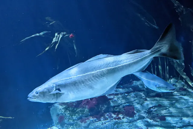 SaitheRegular local target11 placesPortballintrae, Ballycastle, Cushendun and Torr Head, Carnlough and 7 moreOver bay, beach, harbour wall, headland, rock mark
 Ballan wrasseRegular local target10 placesPortrush and Ramore Head, Ballygalley, The Black Arch, Larne, Ballintoy and 6 moreOver bay, beach, harbour wall, headland, island, rock markAround May–Oct
 Atlantic codRegular local target7 placesPortrush and Ramore Head, The Black Arch, Larne, Carnlough, Waterfoot and Red Bay and 3 moreOver bay, beach, harbour wall, headland, rock markAround Jan–Mar, Aug–Dec
 European sea bassRegular local target7 placesPortstewart Strand, The Bann mouth at Castlerock, Ballycastle, Glenarm and 3 moreOver beach, estuary, harbour wall, surf beachAround May–Oct
Also documented from the shore: Small-spotted catshark · Conger eel · Bull huss · Dab · European plaice · Brown trout · Atlantic mackerel · Whiting · Thick-lipped grey mullet · Turbot
From a boat · 3
Spearfishing · 2
- Ballan wrasseRegular local target5 placesThe Black Arch, Larne, Ballintoy, Portmuck and Browns Bay, Garron Point and 1 moreOver harbour wall, rock markAround May–Sept
- PollackRegular local target4 placesGarron Point, The Black Arch, Larne, Ballintoy, DunseverickOver harbour wall, rock markAround May–Sept
What these strengths mean
- Characteristic of this water
- This water is strongly identified with this species by the sources that cover it.
- Regular local target
- Fishing sources describe this as a normal local target here, not merely as caught.
- Seasonal
- Well supported, and concentrated in part of the year rather than spread through it.
- Recorded here
- At least one credible public account of this species being caught here. That is all it means.
- How breadth is counted
- A fish documented at six marks is shown as six marks: breadth never raises the strength on its own. A fishery account describes the fishing; a recorded catch reports one specific catch. How evidence is weighed.
How people fish here
6 methods are recorded on the places documented here, counted from the records themselves rather than from what is practised in the country. Each opens a full guide to the technique.
Ledgering
Recorded at 18 places here, over harbour wall, beach, rock mark, bay.
Fishing a bait on the bottom held by a weight, with no float — the simplest way to fish at distance, in depth, or in wind.
Documented on the same ground: European flounder, Atlantic cod, Ballan wrasse, Brown trout, Bull huss, Conger eel.
Float fishing
Recorded at 11 places here, over harbour wall, headland, rock mark, bay.
Suspending a bait at a controlled depth beneath a buoyant indicator — the most visual, most controllable and most widely applicable method in angling.
Documented on the same ground: Atlantic cod, Ballan wrasse, Bull huss, Conger eel, Dab, European flounder.
Spinning
Recorded at 11 places here, over rock mark, bay, harbour wall, headland.
Casting an artificial lure and retrieving it so that it moves like something alive — the most direct form of lure fishing.
Documented on the same ground: Atlantic cod, Ballan wrasse, Brown trout, Bull huss, Conger eel, Dab.
Kayak fishing
Recorded at 7 places here, over harbour wall, bay, estuary, headland.
A platform rather than a technique: quiet, shallow-draught access to water no other craft reaches, bought at the price of exposure, and a discipline where the decision not to launch is part of the skill.
Documented on the same ground: European flounder, Atlantic cod, Ballan wrasse, Brown trout, Bull huss, Conger eel.
Dry fly fishing
Recorded at 1 place here, over river reach.
Presenting a floating artificial to a fish feeding at the surface, so that it drifts exactly as a natural insect would.
Jigging
Recorded at 1 place here, over island.
Working a weighted lure with a rising-and-falling motion, usually vertically, so it behaves like a wounded or fleeing baitfish.
Documented on the same ground: Conger eel, Pollack, Atlantic mackerel, Ballan wrasse.
These are the methods documented at the places FishingHQ holds here. A species listed beside a method is documented on the same ground, which is not the same as being taken that way — where a source establishes the method a fish was caught on, it is stated on that place’s own page. All fishing methods.
The fishing year here
The months the records under this area actually name, tightest season first. This is “observed in these months” rather than a season: a species whose months nobody recorded is not listed, because a gap in the evidence is not a year-round fishery.
- Conger eelAugust to September
- Atlantic mackerelJune to September
- European plaiceJune to September
- Thick-lipped grey mulletJune to September
- European flounderNovember to March
- Small-spotted catsharkJune to October
- PollackMay to October
- Ballan wrasseMay to October
- European sea bassMay to October
- WhitingOctober to March
- Atlantic codAugust to March
What dominates
Rock and ledge shore fishing over deep water for pollack, wrasse, coalfish and conger, which is what the basalt ground gives and what this coast is best known for. Clean-ground beach fishing on the strands for bass, flatfish, ray and dogfish. Small-boat and charter fishing around the headlands, the sounds and the offshore reefs, entirely organised around the state of the tide. Lure fishing along the rock and in the tide races. Harbour and pier fishing, which is where much of the coast's casual fishing is done. Diving, which has a strong following around Rathlin because of the clarity and the wrecks. Creeling for crab and lobster along the rock coast.
The water available
Columnar basalt cliff and blocky boulder ground with extensive kelp; deeply gullied wave-cut platform; chalk exposures and sea caves; deep water immediately off the headlands; strong tidal races and overfalls at the points and in the sounds; long clean sand strands with dune systems in the bays; an offshore island with its own reef, sound and wreck ground; and small harbours and piers throughout.
How the rules are structured
Northern Ireland's fisheries framework is its own and is NOT the England and Wales framework. Sea angling requires no licence, but conservation measures, minimum sizes and species-specific rules apply and are administered by the Northern Ireland department responsible for fisheries. Freshwater and migratory fishing require both a rod licence and a separate permit, and the licensing body differs between parts of the country — the Foyle system in particular is administered by a cross-border body rather than by the Northern Ireland department, which catches visitors regularly. Substantial parts of this coast carry conservation designation for their geology, their habitats and their seabirds, and the Causeway itself is a World Heritage Site, all of which constrain access and activity independently of any fishing rule. Shellfish harvesting areas are classified for food safety. FishingHQ does not state what any current rule is.
Who to ask
- The Northern Ireland department responsible for agriculture, environment and rural affairs, which administers sea fisheries measures and marine conservation here.
- The Loughs Agency, the cross-border body administering the Foyle and Carlingford systems, whose licensing arrangements differ from the rest of Northern Ireland.
- The Northern Ireland Environment Agency and the site management bodies, where a coastal, geological or World Heritage designation affects access or activity.
- The National Trust or other landowner, where access to the shore crosses land in their ownership.
- The harbour authority at each port, for access to and fishing from harbour structures.
Words you will meet
- Sound
- A channel between an island and the mainland, or between two islands. On this coast the sounds around Rathlin carry the concentrated tidal exchange of the North Channel and run at speeds that make them a serious navigational matter rather than a short cut.
- Strand
- The Irish and Scots word for a long sandy beach. The strands between the headlands here are a completely different fishery from the rock either side of them, and the word marks the distinction usefully.
- Glen
- One of the steep valleys running down to this coast from the basalt plateau behind it. The glens deliver small spate rivers to the sea, which bring sea trout into the coastal margin and organise a good deal of local fishing around their mouths.
Conditions and hazards
The tide governs everything here and it does so at a scale visitors underestimate. Streams past the headlands and through the sounds run faster than a small craft can make ground against, produce overfalls and standing waves that form and disperse on the tidal clock rather than with the weather, and are made dramatically worse by wind against stream. A passage made comfortably on the slack is no information about the return. Ashore, the basalt gives excellent fishing platforms with deep water in front and vertical rock behind, and swell — including Atlantic ground swell that arrives independently of local wind — reaches them in sets. Being swept from a ledge rather than falling in is the mechanism, and the recovery problem is acute because the water is immediately deep and the rock behind offers nothing to climb. The gullied platform is a trip hazard filling with water. Cliff access to many marks is steep and in places unstable. Water is cold year-round so cold water shock decides an immersion in any month. The strands generate rip currents when a sea is running. And the coast is exposed to northerly and westerly weather with no shelter at all.
Basalt underwater: what a lava coast gives an angler
The geology here is famous above the waterline and it is at least as consequential below it, because basalt breaks in a way that other rock does not.
HOW BASALT WEATHERS. Cooling lava contracts and fractures, frequently into the polygonal columns this coast is celebrated for, and always into a mass of straight-edged joints. The sea exploits those joints rather than abrading the rock face, so a basalt coast erodes into blocks, steps, deep straight-sided gullies and sheer faces rather than into the rounded ledges and smooth platforms of sandstone.
UNDERWATER THAT PRODUCES A VERY SPECIFIC HABITAT. Vertical faces and overhangs. Deep narrow gullies that hold water and shelter through every state of tide. Enormous quantities of broken block on the seabed with gaps under and between it. And kelp forest over the top of all of it wherever there is light.
WHICH IS EXACTLY WHAT WRASSE, POLLACK AND CONGER WANT. Ballan wrasse are a structure animal that needs holes to retreat into and hard-shelled food to crush; a fractured basalt reef supplies both in quantity. Pollack hold on the kelp edges and in the water column over the gullies, ambushing along the vertical. Conger occupy the gaps beneath the blocks and stay there for years. This coast's rough-ground shore fishery is a direct consequence of the way the lava cooled.
IT ALSO EXPLAINS THE TACKLE. Ground this broken takes terminal tackle every session, so the rigs here are built to be lost cheaply — rotten-bottom links, expendable leads, and a working assumption that whatever goes into the gully is not coming out. Float and light lure fishing over the kelp is the alternative that avoids the ground rather than fighting it.
THE CHALK EXPOSURES ADD SOMETHING DIFFERENT. Where white chalk underlies the basalt it produces caves, arches and a paler, softer ground with its own community, and the contrast between the two rocks a few metres apart is unusually sharp.
AND THE STRANDS BETWEEN THE HEADLANDS ARE THE COUNTERWEIGHT. Clean sand, no structure, and a completely different fishery: bass in the surf, flatfish and ray over the open ground, dogfish at night. Tackle that is right for the basalt is wrong on the strand and the reverse. An angler on this coast is really choosing between two fisheries every time they choose a mark.
Backed by research — why, and the sources (4)
Supported by peer-reviewed research or fisheries science. The sources are listed and can be checked.
- JNCC species and habitat conservation advice — Joint Nature Conservation Committee (Conservation authority)Relied on for: Designation, habitat description and conservation status of the marine and coastal habitats named, and the species characteristically associated with them.States this directlyCitation checked — the work exists and is described correctly
- The Fishes of the British Isles and North-West Europe — Macmillan, 1969 (Reference work)Relied on for: Distribution, habitat association and biology of the fishes of the British Isles and north-west Europe named here.States this directlyCitation checked — the work exists and is described correctly
- Cefas science, advice and data on marine and freshwater environments — Centre for Environment, Fisheries and Aquaculture Science (Government fisheries body)Relied on for: Marine environmental science for UK shelf seas, including tidal range and stream, sediment characterisation, coastal process and the monitoring programmes that describe them.States this directlyCitation checked — the work exists and is described correctly
- ICES Advice on fishing opportunities, catch and effort — International Council for the Exploration of the Sea (Scientific institute)Relied on for: Ecoregion description, stock distribution and the hydrography of the sea areas assessed.States this directlyCitation checked — the work exists and is described correctly
Fishing a coast where the tidal atlas outranks the weather forecast
Most British and Irish shore anglers plan a session around wind and swell and treat the tide as a detail. On this coast the ordering is reversed, and getting that ordering right is most of what local knowledge consists of.
WHY THE TIDE DOMINATES HERE. The North Channel is the connection between the Irish Sea and the Atlantic, and a very large volume of water moves through it on every tide. Where that flow passes a headland it accelerates, and where it passes through a sound it accelerates further. The result is that the water in front of a mark on this coast is not a static thing with fish in it — it is a moving system whose speed and direction change through the day on a predictable schedule.
WHAT THAT DOES FOR THE FISHING. A hard stream past a point concentrates food and disorients it, so predators sit in the slack behind structure and take what comes past. That makes the productive window at any given mark a specific part of a specific tide, frequently short, and it moves through the month with springs and neaps. An angler fishing the right mark at the wrong state may as well be fishing a swimming pool.
SO THE PRACTICE IS TIDE-LED. Boat fishing here is planned around slack water at the specific ground rather than around a convenient departure time. Shore fishing on the rock is planned around when the stream runs past the mark and when the ledge is reachable and leavable. Lure fishing in the races is a matter of being there for perhaps ninety minutes.
THE DISCIPLINES THIS COAST SUPPORTS. Heavy ledgering over the broken basalt with expendable terminal tackle. Float fishing over kelp for wrasse and pollack, which suits the deep water close in unusually well. Lure fishing along the rock and in the tide races, which has grown a great deal. Clean-ground beach casting on the strands for bass, ray and flatfish. Small-boat and charter work around the headlands, the sounds and the offshore reefs. Pier and harbour fishing, which is where most casual fishing here happens. And diving around Rathlin, which the clarity and the wrecks support and which the streams constrain absolutely.
THE SEASON IS ATLANTIC-INFLUENCED rather than Irish Sea. Wrasse, pollack and mackerel from late spring through autumn on the rock. Bass on the strands and around the rock in the warmer months. Ray and flatfish over the clean ground. Conger through the year in the deep gullies. Winter is thinner than on the east coast and the weather closes far more of it.
What experienced anglers do — why, and the sources (4)
Widely and independently recommended by experienced anglers and specialist sources. This is real angling knowledge, not proof: controlled evidence for it is limited, and FishingHQ records it as convention rather than as a demonstrated effect.
- Sea Angler — Bauer Media (Specialist angling publication)Relied on for: Long-running published description of British and Irish sea angling practice by region and by ground type.FishingHQ's interpretation of what it saysCitation checked — the work exists and is described correctly
- General angling website restatements of established technique — Various (Credible secondary source)Relied on for: Widely restated descriptions of which practices are conventionally used in the waters named, recorded as practitioner consensus rather than as scholarship.Background and mechanism onlyCitation checked — the work exists and is described correctly
- Fishers' Craft and Lettered Art: Tracts on Fishing from the End of the Middle Ages — University of Toronto Press, 1997 (Scientific literature)Relied on for: That fishing traditions develop around the water and fish available to them, and the historical method of reading such traditions.Background and mechanism onlyCitation checked — the work exists and is described correctly
- General angling website restatements of established technique — Various (Credible secondary source)Relied on for: Widely restated descriptions of regional angling practice, recorded as practitioner consensus rather than as scholarship.Background and mechanism onlyCitation checked — the work exists and is described correctly
A stream that outruns any small craft, on a coast with vertical rock behind you
This coast presents two severe hazards that are unrelated to each other, and the visitors who get into trouble are usually the ones who prepared for the wrong one.
THE FIRST IS THE TIDE AND IT IS A MATTER OF SPEED RATHER THAN SKILL. Streams past the headlands and through the sounds run faster than a kayak can paddle or a small outboard can push against. That is not a description of difficult conditions; it is an arithmetic statement about a craft's maximum speed. A boat that enters the acceleration is going where the water goes, and where the water goes is into overfalls and standing waves.
AND THE MISTAKE IS ALWAYS MADE ON THE APPROACH. From up-tide the water looks manageable, and by the time it does not the craft is already committed. Add wind against the stream — which stands the whole race up into short steep breaking water out of all proportion to the wind strength — and the margin disappears entirely.
WHICH GIVES A PLANNING ORDER THAT VISITORS FIND STRANGE. The tidal stream atlas is the primary document and the wind forecast is the secondary one. Know when the stream turns at the specific headland or sound rather than at a distant standard port. Do not attempt a sound on springs. Plan the return as carefully as the outward passage, because a passage made on the slack tells nobody anything about an hour and a half later. Treat visible overfalls as a boundary with a wide margin, since their position moves through the cycle.
THE SECOND HAZARD IS THE ROCK AND IT IS A MATTER OF SETS. The basalt gives superb fishing platforms with deep water immediately in front of them, which is why they are worth standing on. Swell arrives in sets, and on this coast some of it is Atlantic ground swell that comes independently of local wind and gives no warning in the sky. A ledge dry for twenty minutes is not evidence about the next wave.
THE RECOVERY PROBLEM IS WHAT MAKES IT LETHAL. Go in off a basalt ledge and the water is immediately deep, the face behind is vertical, kelp-covered and offers nothing to climb, and the gullies that make the fishing are surge channels. Watch a mark through several full set cycles from above the wet line before committing. Choose a platform with a way UP behind it rather than only a place to stand. Wear a buoyancy aid on the rocks. Do not fish exposed rock alone.
THE GULLIED PLATFORM ADDS A THIRD, QUIETER MECHANISM. Deep straight-sided gullies fill and empty with the surge, they are trip hazards, and moving across them in the dark or in the wet is how people are injured a long way from access.
AND COLD RUNS UNDER ALL OF IT. The water here is cold in every month, immersion produces the gasp response and loss of breathing control within seconds, and the strands produce rip currents when a sea is running. Carry the means of calling for help on your person, tell somebody the mark and the return time, and check both the tidal streams and the current inshore waters forecast before going.
Official guidance — why, and the sources (4)
Stated by a fisheries authority, scientific institute or recognised angling body. Authoritative, but summarising rather than demonstrating.
- Rock fishing safety and the declared lifejacket areas of New South Wales — NSW Department of Primary Industries and Surf Life Saving NSW (Water-safety or diver-training authority)Relied on for: Rock-platform fishing hazards, the mechanism by which anglers are swept from platforms by sets rather than by average conditions, and the measures that address it.States this directlyCitation checked — the work exists and is described correctly
- RNLI water safety guidance: cold water shock and Float to Live — Royal National Lifeboat Institution (Water-safety or diver-training authority)Relied on for: Cold water shock, immersion response and the advice to carry a means of calling for help on the person.States this directlyPassage read and verified
- RNLI water safety guidance: cold water shock and Float to Live — Royal National Lifeboat Institution (Water-safety or diver-training authority)Relied on for: Cold water shock and the immersion response, tidal cut-off, and water-safety guidance for shore anglers and small-craft users.States this directlyPassage read and verified
- Met Office shipping forecast, inshore waters forecast and marine warnings — Met Office, United Kingdom (Government fisheries body)Relied on for: That inshore waters forecasts, sea state and swell are the operative inputs for shore and small-craft decisions in these waters.States this directlyCitation checked — the work exists and is described correctly
Some of what lives here
Fish recorded here that FishingHQ holds a reviewed photograph of. It is not a complete list of what The Causeway and Antrim coast holds, and it is not a prediction that you will catch any of them — it is a way in to the ones we can show you.
- PollackA fast gadoid that hunts up off reefs and wrecks and takes a lure on the drop — and the sea fish most likely to convert a bait angler to lure fishing.
Wilhelm Thomas Fiege — CC BY-SA 4.0, via Wikimedia Commons
- Ballan wrasseA long-lived rocky-ground resident that begins life female and may change sex — and the species that turned rock marks into a lure fishery.
Diego Delso — CC BY-SA 4.0, via Wikimedia Commons
 Conger eelA very large scaleless eel of wrecks, rock and harbour walls, reaching three metres, and among the most powerful and most genuinely dangerous fish to handle in European seas.
Holger Krisp — CC BY 3.0, via Wikimedia Commons
- European sea bassA fast, predatory inshore fish that hunts in broken water and surf, and one of the most closely managed recreational species in European seas.
Julien Renoult — CC BY 4.0, via Wikimedia Commons
 Atlantic mackerelA fast, schooling, obligate-swimming pelagic fish that arrives inshore in summer in enormous numbers, and the species most sea anglers catch first.
Hans Hillewaert — CC BY-SA 4.0, via Wikimedia Commons
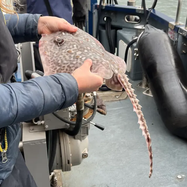 Thornback rayThe commonest European ray, covered in thorn-like bucklers, laying horny egg cases known as mermaid's purses, and requiring careful handling on release.
Ella McCausland — CC BY, via iNaturalist
Places within this area
Publicly documented fishing geography. FishingHQ describes what the ground is; it does not say whether you may fish it, and every one of these sends that question to the body that holds the answer. Browse every place in this part of the world.
Who to ask before fishing any of these
FishingHQ does not know the current access position here. Sea angling access in Northern Ireland is governed by landowner permission, harbour and council byelaws, and fisheries and conservation measures, all of which change. Check the current position with the Department of Agriculture, Environment and Rural Affairs, the harbour or council, and the landowner before going.
FishingHQ does not know the current access position here. Sea angling access in Northern Ireland is governed by landowner permission, harbour and council byelaws, and fisheries and conservation measures, all of which change. Check the current position with the Department of Agriculture, Environment and Rural Affairs, the harbour or council, and the landowner before going. This water is tidal and transitional, so the freshwater regime may also apply above the tidal limit: FishingHQ does not know the current access position here. Angling in Northern Ireland generally requires both a rod licence from the relevant fisheries body and a separate permit for the water, and the two are issued by different bodies. Rules, seasons and permit arrangements change. Check with the Department of Agriculture, Environment and Rural Affairs, the Loughs Agency where relevant, and the permit issuer before going.
FishingHQ does not know the current access position here. Angling in Northern Ireland generally requires both a rod licence from the relevant fisheries body and a separate permit for the water, and the two are issued by different bodies. Rules, seasons and permit arrangements change. Check with the Department of Agriculture, Environment and Rural Affairs, the Loughs Agency where relevant, and the permit issuer before going.
Portrush and Ramore Head
Headland · Salt water
A basalt and dolerite headland projecting north from the Antrim coast, with rock platforms, gullies and the Skerries — a low reef chain — lying a short distance offshore. Hard igneous rock, deep gullies and clean sand in the bays either side.
Fully open to the North Atlantic from west through north-east. This coast receives ocean swell with nothing between it and Iceland.
Particular to this ground: cliffs and rock platforms, cold water shock, weather and lightning.
Severe hazards of The Causeway and Antrim coast apply here: moving water and currents.
Particular to this water: This ground carries conservation designations that constrain access, vehicles, bait collection and disturbance independently of any fishing rule.
Rathlin Island and the Sound
Island · Salt water
An L-shaped basalt and chalk island five kilometres off Ballycastle, with high cliffs on the west and north, a raised beach shore on the east, and a five-kilometre sound between it and the mainland.
Wholly exposed. The island sits in the North Channel between Ireland and Scotland and takes weather from every direction.
Particular to this ground: moving water and currents, cliffs and rock platforms, cold water shock.
Particular to this water: Shellfish harvesting areas are classified for food safety and are opened and closed on monitoring results a gatherer cannot see. Neither cooking nor appearance removes a biotoxin. Check the current classification with the local authority before taking anything. This ground carries conservation designations that constrain access, vehicles, bait collection and disturbance independently of any fishing rule.
Portstewart Strand
Beach · Salt water
Two miles of clean Atlantic sand backed by a large dune system, running east from a basalt and schist headland to the Bann mouth, with a strong longshore set.
Severe hazards of The Causeway and Antrim coast apply here: moving water and currents, cliffs and rock platforms, cold water shock.
The Bann mouth at Castlerock
Estuary · Brackish water
The single outflow of Lough Neagh reaching the Atlantic between long training walls, over sand, with a strong ebb and a migratory run passing through it.
Severe hazards of The Causeway and Antrim coast apply here: moving water and currents, cliffs and rock platforms, cold water shock.
Portballintrae
Bay · Salt water
A small basalt-bounded sand bay on the Causeway coast, with rock reef at both horns, a drowned Armada wreck site offshore and clean sand in the middle.
Severe hazards of The Causeway and Antrim coast apply here: moving water and currents, cliffs and rock platforms, cold water shock.
Ballycastle
Harbour wall · Salt water
A stone harbour on the north Antrim coast facing Rathlin Sound, over sand and basalt rubble, with a very strong tidal stream running past the bay mouth.
Severe hazards of The Causeway and Antrim coast apply here: moving water and currents, cliffs and rock platforms, cold water shock.
Cushendun and Torr Head
Headland · Salt water
The closest point of Ireland to Scotland, where a schist headland projects into the North Channel with very deep water immediately offshore and a race running past it.
Severe hazards of The Causeway and Antrim coast apply here: moving water and currents, cliffs and rock platforms, cold water shock.
Carnlough
Harbour wall · Salt water
A limestone-built harbour in a basalt-walled glen bay on the Antrim coast road, over sand and boulder with reef ground round the points.
Severe hazards of The Causeway and Antrim coast apply here: moving water and currents, cliffs and rock platforms, cold water shock.
11 more places in this area
Glenarm
Harbour wall · Salt water
A small marina and harbour beneath the Antrim escarpment, with chalk and basalt shore either side and deep water close in along the coast road.
Severe hazards of The Causeway and Antrim coast apply here: moving water and currents, cliffs and rock platforms, cold water shock.
The River Bush
River reach · Fresh water
A small, clean, gravel-bedded north Antrim river with one of the longest-running salmon research programmes in Europe on it, and a full trapping facility at Bushmills.
Severe hazards of The Causeway and Antrim coast apply here: moving water and currents, cliffs and rock platforms, cold water shock.
Waterfoot and Red Bay
Bay · Salt water
The wide sand and shingle bay at the foot of Glenariff, closed to the north by Cushendall and to the south by the red sandstone cliffs the bay is named for, with an old ruined pier at the southern end and a more intact one to the north. Clean sand across the bay, a reef about a hundred and fifty metres off the Limerick Point ledges at the northern end, and rough broken bed either side of the pier.
Open east and south-east into the North Channel, sheltered from the prevailing south-westerlies by the glen behind it. A bay that fishes in weather that closes the exposed Antrim rock.
Particular to this ground: cold water shock.
Severe hazards of The Causeway and Antrim coast apply here: moving water and currents, cliffs and rock platforms.
Particular to this water: This ground carries conservation designations that constrain access, vehicles, bait collection and disturbance independently of any fishing rule.
Garron Point
Rock mark · Salt water
A basalt and chalk headland below the Garron plateau where the coast road is squeezed onto a shelf between the cliff and the sea, with a bed of broken boulder and reef offshore that two independent guides describe as among the roughest fishable ground in Northern Ireland. The ledges south of the point, between a ruined pier and a disused quay, are the fished platform.
Open from north-east through south-east across the North Channel to the Mull of Kintyre and the Ayrshire coast, with nothing between.
Particular to this ground: cliffs and rock platforms, cold water shock, entanglement.
Severe hazards of The Causeway and Antrim coast apply here: moving water and currents.
Particular to this water: This ground carries conservation designations that constrain access, vehicles, bait collection and disturbance independently of any fishing rule.
Ballygalley
Beach · Salt water
A steep sand and shingle beach on the Antrim coast road three miles north of Larne, closed at its northern end by Ballygalley Head — a volcanic plug of columnar dolerite standing off the shoreline. Clean steep-shelving ground off the beach and hard broken rock off the head, which is why two guides give the two ends different fish.
Open east and north-east across the North Channel. A beach that needs some sea running to fish at its best and is unfishable when that sea becomes a swell on the head.
Particular to this ground: cold water shock, cliffs and rock platforms.
Severe hazards of The Causeway and Antrim coast apply here: moving water and currents.
The Black Arch, Larne
Rock mark · Salt water
The rocks on the southern side of the tunnel cut through the basalt cliff at Blackcave Head, where the Antrim coast road begins two miles north of Larne. Hard igneous rock running straight into deep water, with the road immediately above and the fished ground a short scramble below it.
Open east and north-east across the mouth of Larne Lough into the North Channel, with the Scottish coast twenty miles off.
Particular to this ground: cliffs and rock platforms, cold water shock, moving water and currents.
Benone Strand and Magilligan
Surf beach · Salt water
Seven miles of clean firm sand running from Magilligan Point at the mouth of Lough Foyle east to Downhill, backed by a large dune system beneath the basalt scarp of Binevenagh. The council describes the sand as without rock, shingle or weed, and it is level enough along most of its length to be driven on.
Open north and north-west to the full Atlantic fetch. This is a surf beach in the proper sense and the shore directory says it fishes well in a good surf rather than in spite of one.
Particular to this ground: cold water shock, moving water and currents.
Severe hazards of The Causeway and Antrim coast apply here: cliffs and rock platforms.
Particular to this water: A live military range adjoins part of this shore and is signalled by flags and by published firing times. Whether any given stretch may be entered on any given day is the range authority's to answer and nobody else's, and it changes daily. This ground carries conservation designations that constrain access, vehicles, bait collection and disturbance independently of any fishing rule.
Ballintoy
Harbour wall · Salt water
A small stone harbour cut into the limestone and basalt of the north Antrim coast, with white chalk rocks to the right of it and sandbanks lying at casting range beyond. Hard rock inshore over clean sand further out, and blowholes in the platform that throw water in a northerly sea.
Fully open north to the Atlantic. The directory says the mark fishes best after a really strong northerly gale, which is a statement about what the swell does to the sandbanks rather than an invitation to fish in one.
Particular to this ground: cliffs and rock platforms, cold water shock, weather and lightning.
Severe hazards of The Causeway and Antrim coast apply here: moving water and currents.
Particular to this water: This ground carries conservation designations that constrain access, vehicles, bait collection and disturbance independently of any fishing rule.
Portmuck and Browns Bay
Harbour wall · Salt water
Two adjoining marks at the northern tip of Islandmagee: a small harbour at Portmuck with rough broken ground and weed off the wall, and the clean sandy sweep of Browns Bay a couple of kilometres round, where the seabed is clear enough that a short lob outfishes a long cast.
Portmuck faces east and north-east into the North Channel; Browns Bay is tucked round the point with high ground behind it and is the sheltered half of the pair.
Particular to this ground: cold water shock, cliffs and rock platforms.
Severe hazards of The Causeway and Antrim coast apply here: moving water and currents.
Dunseverick
Rock mark · Salt water
Basalt rock below the picnic area at the eastern end of the Causeway coast path, where the columnar cliffs of the Causeway itself give way to a lower shore of ledges and gullies. Deep water against hard rock with kelp on it.
Fully open north to the Atlantic, taking ground swell generated far away and arriving ahead of any weather.
Particular to this ground: cliffs and rock platforms, cold water shock.
Severe hazards of The Causeway and Antrim coast apply here: moving water and currents.
Particular to this water: This ground carries conservation designations that constrain access, vehicles, bait collection and disturbance independently of any fishing rule.
White Park Bay
Beach · Salt water
A three-kilometre arc of white sand between Ballintoy and Portbradden backed by chalk cliffs and a large unstable dune system, with a stream crossing it. Clean sand throughout, and the fished ground is to the right of the river mouth.
Open north to the Atlantic with the full ocean fetch, and the bay collects the swell that runs along this coast.
Particular to this ground: cold water shock, moving water and currents.
Severe hazards of The Causeway and Antrim coast apply here: cliffs and rock platforms.
Particular to this water: This ground carries conservation designations that constrain access, vehicles, bait collection and disturbance independently of any fishing rule.
Safety
Moving water and currents — Can cause serious injury or death
Tidal streams past the headlands and through the sounds run faster than a kayak can paddle or a small outboard can push against, producing overfalls and standing waves. A craft that enters the acceleration goes where the water goes, and the mistake is made on the approach.
What reduces it: Treat the tidal stream atlas as the primary document and the wind forecast as secondary. Know when the stream turns at the specific place, do not attempt a sound on springs, plan the return as carefully as the outward passage, and give visible overfalls a wide margin.
Worse when:
- On spring tides, when the streams run hardest and the overfalls are largest.
- With wind against the stream, which stands the race into steep breaking water.
Cliffs and rock platforms — Can cause serious injury or death
Basalt ledges put an angler over deep water with vertical kelp-covered rock behind. Swell arrives in sets, including Atlantic ground swell independent of local wind, and a person swept off has no shallow margin and nothing to climb.
What reduces it: Watch a mark through several full set cycles from above the wet line before committing, choose a platform with a way up behind it, wear a buoyancy aid on the rocks, and do not fish exposed rock alone.
Cold water shock — Can cause serious injury or death
The water here is cold in every month. Immersion produces an involuntary gasp and loss of breathing control within seconds, which decides the outcome rather than any swimming afterwards.
What reduces it: Wear a buoyancy aid rather than carry one, carry a means of calling for help on the person, dress for the water rather than the day, and tell somebody the mark and the return time.
Slips, trips and falls — Can cause injury needing treatment
The basalt platform is cut by deep straight-sided gullies that fill and empty with the surge, the rock is weeded and wet, and access to many marks is down steep and in places unstable ground.
What reduces it: Move deliberately and in daylight where possible, wear footwear with real grip, carry a light, and treat the walk in and out as part of the session rather than an afterthought.
Further safety reading
- Rock platform and cliff safety — Basalt ledges put an angler over deep water with vertical kelp-covered rock behind, swell arrives in sets including Atlantic ground swell independent of local wind, and there is no shallow margin to recover onto.
Check the rules before you fish
Fishing laws, bylaws, access rules, seasons, bait restrictions and permitted methods vary by location and can change. Check the current rules from the relevant authority and the water you intend to fish before fishing.
Check with:
- Current national or regional law for where you are fishing
- Current local bylaws
- The relevant fisheries authority
- The landowner, club or fishery whose water it is
- Any restrictions specific to the species or the method you intend to use
Where to go next
What swims here
- Atlantic mackerelThrough the summer in the tide races off the headlands and in the sounds, where the accelerated stream concentrates the small fish they follow.
- Ballan wrasseOn the broken basalt reef, which supplies exactly what the species needs — holes to retreat into and hard-shelled food to crush — in unusual quantity.
- Conger eelIn the gaps beneath the fallen basalt blocks and in the deep straight-sided gullies, where individual fish hold to a single lair for years.
- European sea bassOn the clean sand strands between the headlands and around the rock in the warmer months, near the northern edge of the species' consistent Irish range and moving.
- PollackOver the kelp edges and in the water column above the deep basalt gullies, ambushing along the vertical faces the fractured lava produces.
- Thornback rayOver the clean sand of the bays and the mixed ground offshore, which is a different fishery entirely from the rock either side of it.
How this compares
Environment and conservation
Sources and evidence
- Cefas science, advice and data on marine and freshwater environments — Centre for Environment, Fisheries and Aquaculture Science (Government fisheries body)Relied on for: Marine environmental science for UK shelf seas, including tidal range and stream, sediment characterisation, coastal process and the monitoring programmes that describe them.States this directlyCitation checked — the work exists and is described correctly
- ICES Advice on fishing opportunities, catch and effort — International Council for the Exploration of the Sea (Scientific institute)Relied on for: Ecoregion description, stock distribution and the hydrography of the sea areas assessed.States this directlyCitation checked — the work exists and is described correctly
- JNCC species and habitat conservation advice — Joint Nature Conservation Committee (Conservation authority)Relied on for: Designation, habitat description and conservation status of the marine and coastal habitats named, and the species characteristically associated with them.States this directlyCitation checked — the work exists and is described correctly
- The Fishes of the British Isles and North-West Europe — Macmillan, 1969 (Reference work)Relied on for: Distribution, habitat association and biology of the fishes of the British Isles and north-west Europe named here.States this directlyCitation checked — the work exists and is described correctly
- RNLI water safety guidance: cold water shock and Float to Live — Royal National Lifeboat Institution (Water-safety or diver-training authority)Relied on for: Cold water shock and the immersion response, tidal cut-off, and water-safety guidance for shore anglers and small-craft users.States this directlyPassage read and verified
- Met Office shipping forecast, inshore waters forecast and marine warnings — Met Office, United Kingdom (Government fisheries body)Relied on for: That inshore waters forecasts, sea state and swell are the operative inputs for shore and small-craft decisions in these waters.States this directlyCitation checked — the work exists and is described correctly
Why the 11 connections on this page are here, and the sources
What swims here
Backed by research — 6 connections
Supported by peer-reviewed research or fisheries science. The sources are listed and can be checked.
Atlantic mackerel
A claim that a place contains the ground, water and seasonal conditions the species is associated with. It is a distributional statement about the world, it rests on the regional reference literature, and it deliberately asserts nothing about access, permission or catch.
- The Fishes of the British Isles and North-West Europe — Macmillan, 1969 (Reference work)Relied on for: Distribution and habitat association of the marine, estuarine and freshwater fishes of the British Isles, including which coasts, estuaries and ground types a species occupies.States this directlyCitation checked — the work exists and is described correctly
- FishBase: a global information system on fishes — Froese, R. and D. Pauly, eds. — FishBase Consortium (Scientific institute)Relied on for: Recorded distribution, depth range and habitat association for the species named.States this directlyPassage read and verified
Ballan wrasse
A claim that a place contains the ground, water and seasonal conditions the species is associated with. It is a distributional statement about the world, it rests on the regional reference literature, and it deliberately asserts nothing about access, permission or catch.
- The Fishes of the British Isles and North-West Europe — Macmillan, 1969 (Reference work)Relied on for: Distribution and habitat association of the marine, estuarine and freshwater fishes of the British Isles, including which coasts, estuaries and ground types a species occupies.States this directlyCitation checked — the work exists and is described correctly
- FishBase: a global information system on fishes — Froese, R. and D. Pauly, eds. — FishBase Consortium (Scientific institute)Relied on for: Recorded distribution, depth range and habitat association for the species named.States this directlyPassage read and verified
Conger eel
A claim that a place contains the ground, water and seasonal conditions the species is associated with. It is a distributional statement about the world, it rests on the regional reference literature, and it deliberately asserts nothing about access, permission or catch.
- The Fishes of the British Isles and North-West Europe — Macmillan, 1969 (Reference work)Relied on for: Distribution and habitat association of the marine, estuarine and freshwater fishes of the British Isles, including which coasts, estuaries and ground types a species occupies.States this directlyCitation checked — the work exists and is described correctly
- FishBase: a global information system on fishes — Froese, R. and D. Pauly, eds. — FishBase Consortium (Scientific institute)Relied on for: Recorded distribution, depth range and habitat association for the species named.States this directlyPassage read and verified
European sea bass
A claim that a place contains the ground, water and seasonal conditions the species is associated with. It is a distributional statement about the world, it rests on the regional reference literature, and it deliberately asserts nothing about access, permission or catch.
- The Fishes of the British Isles and North-West Europe — Macmillan, 1969 (Reference work)Relied on for: Distribution and habitat association of the marine, estuarine and freshwater fishes of the British Isles, including which coasts, estuaries and ground types a species occupies.States this directlyCitation checked — the work exists and is described correctly
- FishBase: a global information system on fishes — Froese, R. and D. Pauly, eds. — FishBase Consortium (Scientific institute)Relied on for: Recorded distribution, depth range and habitat association for the species named.States this directlyPassage read and verified
Pollack
A claim that a place contains the ground, water and seasonal conditions the species is associated with. It is a distributional statement about the world, it rests on the regional reference literature, and it deliberately asserts nothing about access, permission or catch.
- The Fishes of the British Isles and North-West Europe — Macmillan, 1969 (Reference work)Relied on for: Distribution and habitat association of the marine, estuarine and freshwater fishes of the British Isles, including which coasts, estuaries and ground types a species occupies.States this directlyCitation checked — the work exists and is described correctly
- FishBase: a global information system on fishes — Froese, R. and D. Pauly, eds. — FishBase Consortium (Scientific institute)Relied on for: Recorded distribution, depth range and habitat association for the species named.States this directlyPassage read and verified
Thornback ray
A claim that a place contains the ground, water and seasonal conditions the species is associated with. It is a distributional statement about the world, it rests on the regional reference literature, and it deliberately asserts nothing about access, permission or catch.
- The Fishes of the British Isles and North-West Europe — Macmillan, 1969 (Reference work)Relied on for: Distribution and habitat association of the marine, estuarine and freshwater fishes of the British Isles, including which coasts, estuaries and ground types a species occupies.States this directlyCitation checked — the work exists and is described correctly
- FishBase: a global information system on fishes — Froese, R. and D. Pauly, eds. — FishBase Consortium (Scientific institute)Relied on for: Recorded distribution, depth range and habitat association for the species named.States this directlyPassage read and verified
How people fish here
What experienced anglers do — 2 connections
Widely and independently recommended by experienced anglers and specialist sources. This is real angling knowledge, not proof: controlled evidence for it is limited, and FishingHQ records it as convention rather than as a demonstrated effect.
Lure fishing
A claim about angling convention rather than about the world: that this place sits within this branch of fishing, which drives the information architecture as well as the page. It rests on independent practitioner description.
- General angling website restatements of established technique — Various (Credible secondary source)Relied on for: Widely restated descriptions of which practices are conventionally used in the waters named, recorded as practitioner consensus rather than as scholarship.Background and mechanism onlyCitation checked — the work exists and is described correctly
- Sea Angler — Bauer Media (Specialist angling publication)Relied on for: Long-running published description of British and Irish sea angling practice by region and by ground type.FishingHQ's interpretation of what it saysCitation checked — the work exists and is described correctly
Sea fishing
A claim about angling convention rather than about the world: that this place sits within this branch of fishing, which drives the information architecture as well as the page. It rests on independent practitioner description.
- General angling website restatements of established technique — Various (Credible secondary source)Relied on for: Widely restated descriptions of which practices are conventionally used in the waters named, recorded as practitioner consensus rather than as scholarship.Background and mechanism onlyCitation checked — the work exists and is described correctly
- Sea Angler — Bauer Media (Specialist angling publication)Relied on for: Long-running published description of British and Irish sea angling practice by region and by ground type.FishingHQ's interpretation of what it saysCitation checked — the work exists and is described correctly
How this compares
What experienced anglers do — 1 connection
Widely and independently recommended by experienced anglers and specialist sources. This is real angling knowledge, not proof: controlled evidence for it is limited, and FishingHQ records it as convention rather than as a demonstrated effect.
Pembrokeshire and the south-west Wales coast
A claim that two places are worth reading against one another, because a reader choosing between them or generalising from one to the other needs to know how the underlying process differs.
- General angling website restatements of established technique — Various (Credible secondary source)Relied on for: Widely restated descriptions of which practices are conventionally used in the waters named, recorded as practitioner consensus rather than as scholarship.Background and mechanism onlyCitation checked — the work exists and is described correctly
- Sea Angler — Bauer Media (Specialist angling publication)Relied on for: Long-running published description of British and Irish sea angling practice by region and by ground type.FishingHQ's interpretation of what it saysCitation checked — the work exists and is described correctly
Safety reading
Official guidance — 1 connection
Stated by a fisheries authority, scientific institute or recognised angling body. Authoritative, but summarising rather than demonstrating.
Rock platform and cliff safety
A claim that a place presents a particular hazard strongly enough that the reader should be sent to the page dealing with it in full, rather than left with the short warning on the place itself.
- RNLI water safety guidance: cold water shock and Float to Live — Royal National Lifeboat Institution (Water-safety or diver-training authority)Relied on for: Cold water shock and the immersion response, tidal cut-off, and water-safety guidance for shore anglers and small-craft users.States this directlyPassage read and verified
Environment and conservation
Backed by research — 1 connection
Supported by peer-reviewed research or fisheries science. The sources are listed and can be checked.
Marine protected areas and spearfishing
A claim that a place raises a particular environmental question, resting on the scientific and conservation literature for the system rather than on angling practice.
- JNCC species and habitat conservation advice — Joint Nature Conservation Committee (Conservation authority)Relied on for: Habitat classification and description for the intertidal, coastal, estuarine and freshwater habitats named, and the species characteristically associated with them.States this directlyCitation checked — the work exists and is described correctly
- Cefas science, advice and data on marine and freshwater environments — Centre for Environment, Fisheries and Aquaculture Science (Government fisheries body)Relied on for: Characterisation of UK inshore sediment, intertidal habitat, estuarine process and the shellfish beds associated with them.States this directlyCitation checked — the work exists and is described correctly
How FishingHQ labels evidence is explained in the evidence policy.