Hobbs Point
Jetty · Brackish water · in Pembrokeshire and the south-west Wales coast
The old slipway and jetty on the north shore of Pembroke Dock, inside the Milford Haven waterway, with deep water off the end and the tide running through. A sheltered mark on a waterway that is fishable in weather that closes the open coast.
Safety: cliffs and rock platforms — can cause serious injury or death. 2 more points apply here.
FishingHQ describes what this place is, not whether you may fish it. Access, permits and who to ask.
What you can catch here
Documented at this place, grouped by how you would be fishing, with how strongly the sources support each one. This is what has been written down, not a forecast, and being listed is never permission to fish.
From the shore · 10
 Conger eelRegular local target1 placeHobbs PointOver jetty
 European sea bassRegular local target1 placeHobbs PointOver jetty
 Atlantic codSeasonal1 placeHobbs PointOver jettyAround Jan–Feb, Nov–Dec
 Atlantic mackerelSeasonal1 placeHobbs PointOver jettyAround Jun–Sept
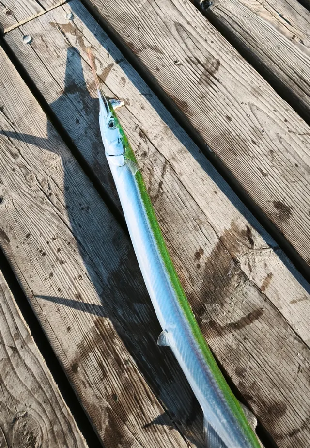 GarfishSeasonal1 placeHobbs PointOver jettyAround Jun–Sept
 Thick-lipped grey mulletSeasonal1 placeHobbs PointOver jettyAround Jun–Sept
 WhitingSeasonal1 placeHobbs PointOver jettyAround Jan–Feb, Nov–Dec
 European flounderRecorded here1 placeHobbs PointOver jetty
Also documented from the shore: Small-spotted catshark · Thornback ray
What these strengths mean
- Regular local target
- Fishing sources describe this as a normal local target here, not merely as caught.
- Seasonal
- Well supported, and concentrated in part of the year rather than spread through it.
- Recorded here
- At least one credible public account of this species being caught here. That is all it means.
- How breadth is counted
- A fish documented at six marks is shown as six marks: breadth never raises the strength on its own. A fishery account describes the fishing; a recorded catch reports one specific catch. How evidence is weighed.
Fish documented nearby, not here
Nothing below has been documented at Hobbs Point itself. Each one has been documented at a named place on the same ground, and the places are listed with it. Treat this as what the water around here holds rather than as a catch list for this mark.
Widely documented on this ground
Documented at three or more neighbouring places, fished a way this place is also fished. That is a pattern about the ground rather than about any one mark, and it is the closest this site comes to saying you will probably meet a fish somewhere nothing has been written about.
From the shore
- Pollack — documented at Whitesands Bay and St David's Head; Giltar Point; Goodwick breakwater (+1 more)
- Ballan wrasse — documented at Whitesands Bay and St David's Head; Giltar Point; St Brides Bay (+1 more)
Also documented at neighbouring places
One or two accounts each, on the ground around here. Enough to know the fish is caught in these waters; not enough to say anything about this place.
From the shore
- Bull huss — documented at St Brides Bay; Tenby South Beach
- Dab — documented at Tenby South Beach
- Black seabream — documented at Tenby South Beach
- Blonde ray — documented at Tenby South Beach
- Starry smooth-hound — documented at Tenby South Beach
- Pouting — documented at Tenby South Beach; Goodwick breakwater
- Saithe — documented at Goodwick breakwater
- Tub gurnard — documented at Tenby South Beach
- Turbot — documented at Tenby South Beach
How people fish it
Practised here: Sea fishing.
Methods the sources name for this ground. Each one is explained in full on its own page.
- Ledgering
Fishing a bait on the bottom held by a weight, with no float — the simplest way to fish at distance, in depth, or in wind.
- Float fishing
Suspending a bait at a controlled depth beneath a buoyant indicator — the most visual, most controllable and most widely applicable method in angling.
- Spinning
Casting an artificial lure and retrieving it so that it moves like something alive — the most direct form of lure fishing.
The ground and the water
- The ground
- The old slipway and jetty on the north shore of Pembroke Dock, inside the Milford Haven waterway, with deep water off the end and the tide running through. A sheltered mark on a waterway that is fishable in weather that closes the open coast.
- Exposure
- Well sheltered inside the waterway; the Haven's topography is what makes it fishable when the coast outside is not.
- Tide and flow
- The Haven's tide runs past the structure and the fishing is organised around the run.
Through the year
Conger through the warm half; garfish and mackerel in summer; mullet in calm summer weather; whiting dominating in winter with cod among them.
The months the sources attach to each species here. Where a species carries no season it is listed underneath rather than assumed to run through the year.
| Species | J | F | M | A | M | J | J | A | S | O | N | D |
|---|---|---|---|---|---|---|---|---|---|---|---|---|
| Atlantic cod — seasonal, recorded in November, December, January, February. | ||||||||||||
| Atlantic mackerel — seasonal, recorded in June, July, August, September. | ||||||||||||
| Garfish — seasonal, recorded in June, July, August, September. | ||||||||||||
| Thick-lipped grey mullet — seasonal, recorded in June, July, August, September. | ||||||||||||
| Whiting — seasonal, recorded in November, December, January, February. |
Recorded here with no season stated: Conger eel, European sea bass, European flounder, Small-spotted catshark, Thornback ray.
Safety
Cliffs and rock platforms — Can cause serious injury or death
Atlantic swell arrives in sets and the largest wave of a set is far bigger than the preceding average. A dry ledge is filled and the backwash takes whatever is on it into deep water against a vertical, kelp-covered face with no shallow margin to recover onto.
What reduces it: Watch the sea for a full set of several minutes before committing to any position. Choose a platform with a way up behind it. Wear a buoyancy aid on the rocks, fish with somebody, and carry the means of calling for help on your person rather than in a bag.
Worse when:
- Long-period Atlantic swell, which arrives in sets far larger than the sea state suggests.
- On a rising tide, when each set reaches further up the platform than the last.
Moving water and currents — Can cause serious injury or death
Tidal streams through the sounds run faster than a kayak can paddle or a small outboard can push against, and produce standing waves, boils and overfalls on springs. A craft that enters the acceleration is committed to wherever the stream takes it.
What reduces it: Plan every movement around the state of the tide before the wind. Know when the stream turns at the specific sound rather than at a distant standard port. Do not attempt a sound on spring tides. Treat visible overfalls as a boundary and allow a wide margin, since their position moves through the tide.
Worse when:
- Spring tides, when the streams run hardest and the overfalls are largest.
- Wind against tide, which stands the race up into breaking water.
Cold water shock — Can cause serious injury or death
Atlantic water on this coast stays cold enough year round that immersion produces an involuntary gasp and loss of breathing control in the first seconds, which is what decides the outcome rather than the swim afterwards.
What reduces it: Wear a buoyancy aid, do not fish alone on exposed rock, and carry a means of calling for help on the person.
Rules and access
FishingHQ does not know the current access position here. Shore angling in Wales is not rod-licensed, but access rights, landowner permission, local authority and harbour byelaws, national and inshore fisheries measures, and site designations all apply and all change. Check the current position with Natural Resources Wales, the harbour or local authority, and the landowner before going. This water is tidal and transitional, so the freshwater regime may also apply above the tidal limit: FishingHQ does not know the current access position here. Freshwater rod fishing in Wales requires a current rod licence AND separate permission from whoever controls the fishing, which is frequently a club, riparian owner or navigation authority rather than a public body. Close seasons, byelaws and local rules apply and change. Check with Natural Resources Wales and with the controlling club or owner before going.
Particular to this water: This is an owned and operated structure. Whether angling is allowed on it, when, from where and on what terms is the operator's decision, is frequently seasonal, and changes without notice.
Who holds the answer:
- Natural Resources Wales, which administers marine and fisheries regulation in Welsh waters.
- The local authority and, where one exists, the harbour authority, for access, byelaws and shellfish classification.
- Natural Resources Wales, for rod licensing, close seasons and fisheries regulation in Wales.
- The club, association or riparian owner that controls the fishing.
- Welsh Government, for sea fisheries policy and measures in Welsh waters, which differ from English ones.
- Natural Resources Wales, for marine and freshwater licensing, designation and enforcement in Wales.
- The Pembrokeshire Coast National Park Authority and the relevant island or reserve managers, where access, landing and disturbance are constrained by designation.
- The Milford Haven Port Authority, for navigation, access and exclusion within the haven.
- The Food Standards Agency and the local authority, for shellfish harvesting area classification and biotoxin closures.
- The Maritime and Coastguard Agency and the RNLI, for safety guidance on this coast.
Nearby fishing
Other publicly documented places within about 40 km, by distance. Positions are approximate public geography and are never exact marks.
- Milford Haven waterway — 5–10 km · Estuary
- Stackpole Quay — 5–10 km · Harbour wall
- Freshwater West — 5–10 km · Beach
- St Govan's Head — 10–25 km · Rock mark
- Broad Haven and Little Haven — 10–25 km · Beach
- Giltar Point — 10–25 km · Headland
- Tenby South Beach — 10–25 km · Surf beach
- Saundersfoot — 10–25 km · Harbour wall
Sources for this place
- Sea Angler — Bauer Media (Specialist angling publication)Relied on for: Long-running published description of British sea angling practice by region, ground type and named mark.FishingHQ's interpretation of what it saysCitation checked — the work exists and is described correctly
- General angling website restatements of established technique — Various (Credible secondary source)Relied on for: Widely restated public descriptions of which places are conventionally fished and how, recorded as practitioner consensus rather than as scholarship, and not relied on for access, permission or any current rule.Background and mechanism onlyCitation checked — the work exists and is described correctly
- British Sea Fishing: Welsh shore marks — British Sea Fishing (Credible secondary source)Relied on for: Mark-by-mark Welsh shore angling: which species are fished for at each named mark, in which season, and with which baits and methods.States this directlyPassage read and verified
How FishingHQ labels evidence is explained in the evidence policy. Last reviewed 2026-08-16.