The Solway Firth
Fishing regions · Last reviewed 2026-08-14
A shallow funnel between Cumbria and Dumfries with one of the largest tidal ranges in Britain over miles of flat sand, where the flooding tide crosses the ground faster than a person can walk.
Safety: tides and being cut off — can cause serious injury or death. One more point applies here.
Being listed here is not permission to fish. What that meansClose
Access, fishing rights, seasons, licences, local bylaws and permitted methods vary and can change. Check current access, permission, local regulations, closures and restrictions before you travel or fish. FishingHQ describes what the ground is and names who holds the answer; it does not hold the answer itself.
Find the authority for a jurisdiction · What FishingHQ does and does not cover
The Solway Firth is a broad, shallow inlet narrowing eastwards between north-west England and south-west Scotland, and its defining property is a consequence of that shape. Water pushed into a funnel that shallows and narrows has nowhere to go but up, so the tidal range at the head of the firth is among the largest in Britain, and the low-water shore is measured in miles rather than metres.
THE CONSEQUENCE IS NOT SCENIC. On flat sand with a large range, the rising tide advances horizontally at a speed that has no relationship to how fast the water is rising. Across the Solway sands the flood moves faster than a person can comfortably walk, and it does not arrive as a front: it fills the channels and gullies first and spreads sideways, so ground that is dry seaward of you is already cut off behind you. This is a documented cause of death on this coast, and it is the reason the firth is treated here as a case study in a mechanism rather than as a destination.
THE GROUND ITSELF is sand, mud, mussel scars and scattered rock, drained by shifting channels that move between years. The scars — beds of mussel and other shellfish on hard patches — are the structure in an otherwise featureless expanse, and they concentrate both food and fish.
THE FISHERY reflects the sediment and the salinity gradient. Flatfish over the sand, bass and mullet working the flood in warmer months, cod and whiting through the cold half of the year, and thornback ray on the deeper channels. The inner firth is strongly brackish with substantial freshwater input from several rivers, and the migratory salmonid interest of those rivers is culturally and legally significant.
AND THE HUMAN HISTORY IS INSEPARABLE FROM THE TIDE. Haaf netting — wading into the flood with a framed net held against the current — is a Solway tradition of Norse origin, practised nowhere else in Britain in the same form, and it exists precisely because the tide here does what it does.
What fishing here is like
A shallow, funnel-shaped, strongly tidal firth where the tide organises everything: when ground is fishable, how long it stays fishable, and whether leaving is still an option. The fishing is shore-dominated over sand and mussel scar, with a species list that turns over completely between summer and winter.
The culture is a working-coast one rather than a resort one. Commercial shellfish interests, a surviving net tradition, and a shore angling community whose knowledge is overwhelmingly about tidal timing rather than about tackle.
What you can target here
One entry per fish, grouped by how you would be fishing — because the answer is a different one from the rocks and from a boat. Each entry says how strongly the sources support it and how much evidence sits behind it. These are documented catches, not a forecast, and none of it is a statement that you may fish any particular ground.
From the shore · 17
 European flounderRegular local target6 placesMaryport harbour and promenade, Silloth promenade and Tommy Legs, Mersehead Sands, Brighouse Bay and 2 moreOver bay, beach, harbour wall, promenade
 Conger eelRegular local target3 placesBurrow Head, Balcary Bay, The Mull of GallowayOver bay, headlandAround May–Oct
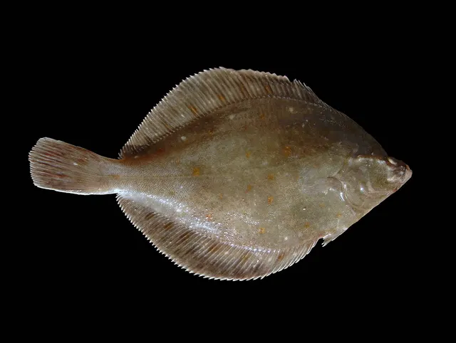 European plaiceRegular local target3 placesFleet Bay, Maryport harbour and promenade, Brighouse BayOver bay, harbour wallAround Jun–Sept
 WhitingRegular local target3 placesSilloth promenade and Tommy Legs, Maryport harbour and promenade, Balcary BayOver bay, harbour wall, promenadeAround Jan–Feb, Nov–Dec
- DabRegular local target2 placesSilloth promenade and Tommy Legs, Balcary BayOver bay, promenade
- Starry smooth-houndRegular local target2 placesWigtown Bay, Silloth promenade and Tommy LegsOver bay, promenade
Also documented from the shore: Small-spotted catshark · Pollack · Atlantic cod · Atlantic mackerel · Bull huss · Thornback ray · Saithe · Tub gurnard · Ballan wrasse · European sea bass · Turbot
From a kayak · 6
 Atlantic codRepeatedly reported2 places · 2 fishery accounts · 1 sourcePortpatrick, Port LoganOver harbour wallSources name Kayak fishing with Soft plasticsAround May, Aug, NovObserved 2020–2022
 PollackRepeatedly reported2 places · 6 fishery accounts · 1 sourcePortpatrick, Port LoganOver harbour wallSources name Kayak fishing with Soft plasticsAround Apr–May, Aug, NovObserved 2020–2024
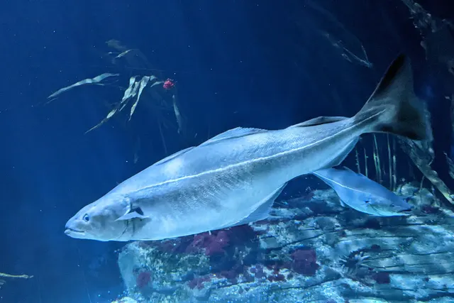 SaitheRepeatedly reported2 places · 2 fishery accounts · 1 sourcePortpatrick, Port LoganOver harbour wallSources name Kayak fishingAround Apr–MayObserved in 2022
 Atlantic mackerelRepeatedly reported1 place · 1 fishery account · 1 sourcePort LoganOver harbour wallSources name Kayak fishingAround AugObserved August 2022
- Cuckoo wrasseRepeatedly reported1 place · 1 fishery account · 1 sourcePort LoganOver harbour wallSources name Kayak fishingAround AugObserved August 2022
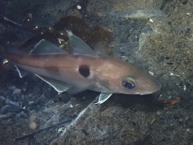 HaddockRepeatedly reported1 place · 1 fishery account · 1 sourcePort LoganOver harbour wallSources name Kayak fishingAround AugObserved August 2022
What these strengths mean
- Regular local target
- Fishing sources describe this as a normal local target here, not merely as caught.
- Seasonal
- Well supported, and concentrated in part of the year rather than spread through it.
- Repeatedly reported
- Several independent public accounts. Enough to say it happens more than once; not enough to call it a fishery.
- Recorded here
- At least one credible public account of this species being caught here. That is all it means.
- How breadth is counted
- A fish documented at six marks is shown as six marks: breadth never raises the strength on its own. A fishery account describes the fishing; a recorded catch reports one specific catch. How evidence is weighed.
How people fish here
6 methods are recorded on the places documented here, counted from the records themselves rather than from what is practised in the country. Each opens a full guide to the technique.
Ledgering
Recorded at 14 places here, over bay, harbour wall, headland, beach.
Fishing a bait on the bottom held by a weight, with no float — the simplest way to fish at distance, in depth, or in wind.
Documented on the same ground: Conger eel, Dab, European flounder, European plaice, Starry smooth-hound, Whiting.
Float fishing
Recorded at 7 places here, over harbour wall, headland, bay.
Suspending a bait at a controlled depth beneath a buoyant indicator — the most visual, most controllable and most widely applicable method in angling.
Documented on the same ground: Conger eel, European flounder, Atlantic cod, Atlantic mackerel, European plaice, Pollack.
Kayak fishing
Recorded at 6 places here, over harbour wall, bay, estuary, sea loch.
A platform rather than a technique: quiet, shallow-draught access to water no other craft reaches, bought at the price of exposure, and a discipline where the decision not to launch is part of the skill.
Documented on the same ground: Atlantic cod, Atlantic mackerel, Cuckoo wrasse, Haddock, Pollack, Saithe.
Spinning
Recorded at 6 places here, over harbour wall, headland, bay.
Casting an artificial lure and retrieving it so that it moves like something alive — the most direct form of lure fishing.
Documented on the same ground: Conger eel, European flounder, Atlantic mackerel, Pollack, Atlantic cod, Ballan wrasse.
Surfcasting
Recorded at 6 places here, over bay, beach, harbour wall, promenade.
Casting heavy baited tackle from a beach into surf — a method defined by distance, by tide, and by reading water that all looks the same.
Documented on the same ground: Dab, European flounder, European plaice, Starry smooth-hound, Whiting, Atlantic cod.
Feathering and multi-lure traces
Recorded at 1 place here, over headland.
A string of small lures on droppers, worked in the water column — how most people in Britain and Ireland catch their first sea fish, and the method most likely to catch far more than anybody intended.
Documented on the same ground: Conger eel, Atlantic mackerel, Pollack, Bull huss, European sea bass, Small-spotted catshark.
These are the methods documented at the places FishingHQ holds here. A species listed beside a method is documented on the same ground, which is not the same as being taken that way — where a source establishes the method a fish was caught on, it is stated on that place’s own page. All fishing methods.
The fishing year here
The months the records under this area actually name, tightest season first. This is “observed in these months” rather than a season: a species whose months nobody recorded is not listed, because a gap in the evidence is not a year-round fishery.
- Cuckoo wrasseAugust to August
- HaddockAugust to August
- Small-spotted catsharkJune to September
- European plaiceJune to September
- WhitingNovember to February
- Atlantic mackerelJune to September
- Thornback rayMarch to June
- Tub gurnardJune to September
- Conger eelMay to October
- Atlantic codJanuary, February, May, August, November and December
- Bull hussMay to October
- SaitheJanuary, February, April, May, November and December
What dominates
Shore fishing over sand and scar for flatfish, bass, cod and whiting according to season. Beach ledgering at range on the outer firth; much closer-range fishing on the inner where the channels come near the shore at low water. Small-boat and dinghy fishing on the deeper channels, which is a tidal-timing exercise rather than a distance one. Haaf netting for migratory fish under a specific and long-standing licensed tradition. Bait collection over the extensive intertidal sand and mud, which is itself a substantial activity and carries the same tidal hazard as the fishing.
The water available
Vast intertidal sand and mud flats, exposed for miles at low water. Mussel and cockle scars forming hard structure within them. Shifting drainage channels that move between years and fill before the surrounding flats do. Saltmarsh and merse along the inner shores. A strong salinity gradient from the brackish inner firth to fully marine water at the mouth. Scattered rock and shingle on the north and outer shores.
How the rules are structured
The firth is divided between two jurisdictions — England and Scotland — with different fisheries administrations on either side, which is unusual and consequential: rules on the same body of water may differ depending on which shore you are standing on. Sea fisheries matters on the English side and the Scottish side are administered by different bodies, migratory salmonid fisheries are governed separately again and are the subject of long-standing specific regulation, and shellfish gathering is subject to health classification and closure independently of any fishery rule. The haaf net fishery operates under its own licensing arrangements. FishingHQ does not state what any of these rules currently require. Anybody fishing here, and particularly anybody collecting bait or shellfish or intending to take migratory fish, should establish the current position with the relevant authority for the specific shore they are on before starting.
Who to ask
- The relevant national fisheries administration for the shore concerned — different bodies apply on the English and Scottish sides of the same firth
- The relevant salmon fishery board or migratory fisheries authority, for anything concerning salmon and sea trout
- The local authority environmental health service, for shellfish harvesting classification and public health closures
- The coastguard, for tidal and safety information, and as the service that will be called if somebody is cut off
- Local clubs and long-established practitioners, whose knowledge of channel positions is operative safety information rather than a courtesy
Words you will meet
- Haaf net
- A large rectangular net on a wooden frame, held by a person standing in the flooding tide facing the current. A Solway tradition of Norse origin, licensed and long-standing, and practised nowhere else in Britain in this form.
- Scar
- A bed of mussels or other shellfish on hard ground within the sand flats. The structural feature of an otherwise featureless expanse, and where food and fish concentrate.
- Merse
- Saltmarsh along the inner firth, grazed and flooded on the largest tides. The landward edge of the intertidal system and not a place to be caught on a spring flood.
- Bore
- The visible advancing front of the flooding tide, seen on the largest ranges where the water arrives as a wave across flat ground rather than as a rise.
Conditions and hazards
The tidal range is the hazard and it is not a matter of degree — it changes the category of risk. On flat sand with a range of this size, the flood advances horizontally faster than walking pace, fills the drainage channels before it covers the flats, and therefore cuts off ground from behind while the seaward view still looks open. People die here doing exactly that, and most of them were bait digging or walking rather than fishing.
The channels move between years, so knowledge that was accurate a season ago may not be. Fog is frequent and removes every visual reference on ground with no landmarks. The sand is soft in places and holds a foot.
The practical requirements are specific: know the time of low water and the time you will leave before you go out, set an alarm rather than trusting judgement, never go out alone on the flats, carry a means of calling for help that will work when wet, and treat a strong onshore wind and low pressure as reasons the water will arrive higher and earlier than the table says.
Water temperature is low for most of the year and immersion is serious in any month.
The environments, and how the tide sorts them
Four environments sit inside one firth and the tide moves between them twice a day.
THE OPEN SAND FLATS are the dominant ground: fine sediment, worked by the tide, holding worms and small crustaceans and therefore flatfish and the species that follow them in on the flood. At low water they are dry for a considerable distance.
THE SCARS are beds of mussel and other shellfish on harder patches within the sand. They are the only structure available over much of the firth, and they hold a different invertebrate community, which is why the fishing concentrates on and around them.
THE CHANNELS drain the flats and hold water throughout the cycle. They are where fish sit at low water and the route by which the flood arrives, which makes them both the productive ground and the specific hazard.
THE MERSE AND SALTMARSH form the landward edge, flooding only on the biggest ranges, and grading into the brackish inner firth where several rivers enter.
What experienced anglers do — why, and the sources (2)
Widely and independently recommended by experienced anglers and specialist sources. This is real angling knowledge, not proof: controlled evidence for it is limited, and FishingHQ records it as convention rather than as a demonstrated effect.
- Sea Angler — Bauer Media (Specialist angling publication)Relied on for: Contemporary UK sea angling practice as reported by practitioners, including regional ground, species and shore technique.States this directlyCitation checked — the work exists and is described correctly
- Cefas science, advice and data on marine and freshwater environments — Centre for Environment, Fisheries and Aquaculture Science (Government fisheries body)Relied on for: Science on UK marine fisheries, stock distribution, shellfish classification and inshore environmental monitoring.Background and mechanism onlyCitation checked — the work exists and is described correctly
What is caught here, and when
The species list turns over almost completely between the warm and cold halves of the year, which is more pronounced here than on most British coasts because the water over shallow sand warms and cools quickly.
FLATFISH — flounder, dab and plaice — are the constant, feeding over the sand and moving with the tide.
BASS AND MULLET work the flood in the warmer months, following the water onto ground that was dry an hour earlier and feeding on what it uncovers. This is classic flood-tide fishing and it is short-lived on each state.
COD AND WHITING dominate the cold half of the year, and are the traditional winter shore species.
THORNBACK RAY use the deeper channels and the outer firth.
And the rivers entering the firth carry migratory salmon and sea trout, which are of considerable cultural and legal significance and are governed entirely separately from sea angling.
What experienced anglers do — why, and the sources (2)
Widely and independently recommended by experienced anglers and specialist sources. This is real angling knowledge, not proof: controlled evidence for it is limited, and FishingHQ records it as convention rather than as a demonstrated effect.
- The Fishes of the British Isles and North-West Europe — Macmillan, 1969 (Reference work)Relied on for: Distribution, habitat and biology of the fishes of the British Isles and north-west Europe.States this directlyCitation checked — the work exists and is described correctly
- FishBase: a global information system on fishes — Froese, R. and D. Pauly, eds. — FishBase Consortium (Scientific institute)Relied on for: Diet, habitat association, depth range and distribution recorded for the species concerned.States this directlyPassage read and verified
How it is fished, and why the method follows the tide
Almost everything here is shore fishing, and almost every decision is a timing decision rather than a tackle one.
BEACH LEDGERING at range is the standard approach on the outer firth, where the water is a long way out at low tide and the fishing is on the flood.
CLOSER-RANGE FISHING works where channels approach the shore, because the fish are in the channel rather than distributed across the flats.
THE FLOOD IS THE FISHING on most marks. Fish move onto uncovered ground with the rising water, feed on what it exposes, and leave again. A session here is frequently a two-hour window inside a six-hour tide, and knowing which two hours is the whole of the local knowledge.
SMALL-BOAT WORK on the channels is a tidal exercise, not a distance one, and getting the timing wrong means grounding on a falling tide.
BAIT COLLECTION over the flats is substantial in its own right and carries the same hazard as everything else here.
What experienced anglers do — why, and the sources (2)
Widely and independently recommended by experienced anglers and specialist sources. This is real angling knowledge, not proof: controlled evidence for it is limited, and FishingHQ records it as convention rather than as a demonstrated effect.
- Sea Angler — Bauer Media (Specialist angling publication)Relied on for: Contemporary UK sea angling practice as reported by practitioners, including regional ground, species and shore technique.States this directlyCitation checked — the work exists and is described correctly
- The Fishes of the British Isles and North-West Europe — Macmillan, 1969 (Reference work)Relied on for: Distribution, habitat and biology of the fishes of the British Isles and north-west Europe.States this directlyCitation checked — the work exists and is described correctly
Haaf netting, and a fishery that exists because of the tide
Haaf netting is the Solway's distinctive fishery and it is genuinely unlike anything else surviving in Britain. A person wades out into the flooding tide carrying a large rectangular net on a wooden frame, stands facing the current, and holds the net against the flow so that fish moving with the tide swim into it.
The word comes from Old Norse and the technique is attributed to Norse settlement of the firth, which places it among the oldest continuously practised fishing methods in the country. It works here and nowhere else in Britain because it requires exactly this combination: a huge tidal range, flat wadeable ground, and a strong predictable flow carrying migratory fish.
It is licensed, it has been the subject of long and contested regulation as migratory salmonid stocks have declined, and the number of people practising it has fallen substantially. It is included here as culture and history rather than as an activity a reader might take up, and what is currently permitted is a matter for the relevant authority.
What experienced anglers do — why, and the sources (2)
Widely and independently recommended by experienced anglers and specialist sources. This is real angling knowledge, not proof: controlled evidence for it is limited, and FishingHQ records it as convention rather than as a demonstrated effect.
- Sea Angler — Bauer Media (Specialist angling publication)Relied on for: Contemporary UK sea angling practice as reported by practitioners, including regional ground, species and shore technique.States this directlyCitation checked — the work exists and is described correctly
- Angling Trust guidance for anglers — Angling Trust (Angling or fisheries organisation)Relied on for: The structure of angling representation and fisheries governance in England, and the bodies responsible for sea and freshwater angling matters.Background and mechanism onlyCitation checked — the work exists and is described correctly
The words used here
A visitor meets several terms that are either local or used differently from elsewhere.
SCAR for a shellfish bed on hard ground, which elsewhere might be called a bed or a patch. On the Solway it is the standard word and it denotes a fishing feature as much as a geological one.
MERSE for the saltmarsh, a Scots term used on both shores here.
HAAF for the net and the fishery, and by extension for the ground where it is practised.
BORE for the visible front of the advancing flood on the largest tides, a word shared with the Severn and a few other funnel estuaries and describing the same physics.
And the channels themselves carry local names that are used as directions and as hazard references, which is worth knowing because a local warning may be phrased entirely in them.
What experienced anglers do — why, and the sources (2)
Widely and independently recommended by experienced anglers and specialist sources. This is real angling knowledge, not proof: controlled evidence for it is limited, and FishingHQ records it as convention rather than as a demonstrated effect.
- Sea Angler — Bauer Media (Specialist angling publication)Relied on for: Contemporary UK sea angling practice as reported by practitioners, including regional ground, species and shore technique.States this directlyCitation checked — the work exists and is described correctly
- Angling Trust guidance for anglers — Angling Trust (Angling or fisheries organisation)Relied on for: The structure of angling representation and fisheries governance in England, and the bodies responsible for sea and freshwater angling matters.Background and mechanism onlyCitation checked — the work exists and is described correctly
Who governs what, on a firth split between two countries
The Solway is administered by two different national fisheries systems, because the border runs down it. That is unusual in Britain and it has a practical consequence a visitor will not expect: the rules applying to the same body of water may differ according to which shore you are standing on, and moving across the firth can move you between regimes.
Sea fisheries matters are handled by the relevant national and regional bodies on each side. Migratory salmon and sea trout are governed under separate arrangements again, with their own licensing and their own long history of specific regulation. Shellfish gathering is controlled on public health grounds through classification and closure, which operates independently of any fishery rule and can change at short notice. The haaf net fishery has its own licensing.
FishingHQ does not state what any of these currently require. The obligation is to establish the position with the authority responsible for the specific shore before fishing, digging or gathering.
Official guidance — why, and the sources (2)
Stated by a fisheries authority, scientific institute or recognised angling body. Authoritative, but summarising rather than demonstrating.
- Angling Trust guidance for anglers — Angling Trust (Angling or fisheries organisation)Relied on for: The structure of angling representation and fisheries governance in England, and the bodies responsible for sea and freshwater angling matters.Background and mechanism onlyCitation checked — the work exists and is described correctly
- Cefas science, advice and data on marine and freshwater environments — Centre for Environment, Fisheries and Aquaculture Science (Government fisheries body)Relied on for: Science on UK marine fisheries, stock distribution, shellfish classification and inshore environmental monitoring.Background and mechanism onlyCitation checked — the work exists and is described correctly
Places within this area
Publicly documented fishing geography. FishingHQ describes what the ground is; it does not say whether you may fish it, and every one of these sends that question to the body that holds the answer. Browse every place in this part of the world.
Who to ask before fishing any of these
FishingHQ does not know the current access position here. Sea angling in Scotland is not rod-licensed, but access rights under the Scottish Outdoor Access Code carry responsibilities, and harbour, local authority, marine conservation and fisheries measures all apply and all change. Check the current position with the Marine Directorate, the harbour or local authority and the land manager before going.
FishingHQ does not know the current access position here. Sea angling in Scotland is not rod-licensed, but access rights under the Scottish Outdoor Access Code carry responsibilities, and harbour, local authority, marine conservation and fisheries measures all apply and all change. Check the current position with the Marine Directorate, the harbour or local authority and the land manager before going. This water is tidal and transitional, so the freshwater regime may also apply above the tidal limit: FishingHQ does not know the current access position here. Scotland has no general rod licence, and the fishing rights on almost every river and loch belong to somebody: a proprietor, an estate, an angling association or a district salmon fishery board. Permission is a separate question from access, and both change. Check with the relevant fishery board or association before going.
FishingHQ does not know the current access position here. Shore angling in England is not rod-licensed, but access rights, landowner permission, local authority and harbour byelaws, national and inshore fisheries measures, and site designations all apply and all change. Check the current position with the relevant inshore fisheries and conservation authority, the harbour or local authority, and the landowner before going.
The Mull of Galloway
Headland · Salt water
The southernmost point of Scotland: a narrow greywacke peninsula with cliffs on three sides, deep water immediately offshore and a strong race off the head.
Exposed to the Irish Sea and to the North Channel on either side, and the two produce different sea states at the same time.
Particular to this ground: tides and being cut off, cliffs and rock platforms, moving water and currents, cold water shock.
Particular to this water: This ground carries conservation designations that constrain access, vehicles, bait collection and disturbance independently of any fishing rule.
Luce Bay and Sandhead
Bay · Salt water
A large, shallow, south-facing bay between the Rhins and the Machars, floored with clean sand and shell, with extensive intertidal flats at the head and rock at both horns.
Open south to the Irish Sea, so a southerly blows straight into the head of the bay with a long fetch behind it.
Particular to this ground: tides and being cut off, cold water shock, boat safety.
Particular to this water: This ground carries conservation designations that constrain access, vehicles, bait collection and disturbance independently of any fishing rule.
Loch Ryan and Stranraer
Sea loch · Salt water
A large sheltered sea loch on the north of the Rhins, with a shingle spit narrowing its entrance, soft mud and sand inside and a historic native oyster bed still present.
Severe hazards of The Solway Firth apply here: tides and being cut off.
Portpatrick
Harbour wall · Salt water
A small harbour blasted into a hard greywacke cliff coast on the western Rhins, facing Ireland across the North Channel, with deep water and heavy reef ground immediately outside.
Particular to this ground: tides and being cut off.
Kirkcudbright Bay
Estuary · Brackish water
A drying sand and mud estuary on the Solway's northern shore, with a narrow channel, extensive intertidal flats and a large tidal range typical of the whole firth.
Severe hazards of The Solway Firth apply here: tides and being cut off.
The Isle of Whithorn
Harbour wall · Salt water
A drying stone harbour behind a rocky promontory at the southern tip of the Machars, over greywacke rock and gravel, looking south across the Solway to the Isle of Man.
Severe hazards of The Solway Firth apply here: tides and being cut off.
Maryport harbour and promenade
Harbour wall · Salt water
The old harbour arms at the Ellen mouth and the promenade wall running north from them, over a shore of sand with stone rubble along the wall's foot. Sheltered ground on a firth where shelter is the scarce commodity.
Open west and south-west down the firth.
Severe hazards of The Solway Firth apply here: tides and being cut off.
Particular to this water: This is an owned and operated structure. Whether angling is allowed on it, when, from where and on what terms is the operator's decision, is frequently seasonal, and changes without notice.
Silloth promenade and Tommy Legs
Promenade · Salt water
A cobbled promenade and green above a shore of sand, mud and scattered cobble on the inner Solway, with the beaches south of the town running out over ground that dries a very long way. Shallow, coloured, and among the largest tidal ranges in Britain.
Open west down the firth; the Scottish shore is visible across it.
Particular to this ground: tides and being cut off.
7 more places in this area
Mersehead Sands
Beach · Salt water
A wide flat sand beach backed by dune and merse on the Scottish shore of the inner Solway, drying out an enormous distance and with soft ground and creeks in the middle of it. The flatness is the fishing and it is also the danger.
Open south across the firth to the English shore.
Particular to this ground: tides and being cut off, cold water shock.
Balcary Bay
Bay · Salt water
A small bay under the Balcary heughs, with rough rock and boulder off the point at its eastern end and cleaner ground in the bay itself. Deeper water closer in than anywhere else on this shore, which is why the bigger fish are named here.
Open south into the firth, with the point taking the weather.
Particular to this ground: tides and being cut off, cliffs and rock platforms.
Brighouse Bay
Bay · Salt water
A sheltered sandy bay west of the Dee mouth with rock along both arms and kelp on the outer edges. Clean in the middle, broken at the sides — the two grounds a short walk apart.
Open south-west, sheltered by the arms of the bay.
Severe hazards of The Solway Firth apply here: tides and being cut off.
Wigtown Bay
Bay · Brackish water
The largest local nature reserve in Britain: a broad shallow bay of merse, mudflat and sand at the Cree and Bladnoch mouths, drying over most of its area. Soft ground, coloured water and a very large range.
Open south down the bay.
Particular to this ground: tides and being cut off.
Fleet Bay
Bay · Brackish water
A sandy bay of small islands and skerries at the Water of Fleet mouth, with clean sand between the rock and eelgrass on the shallower flats. Sheltered, shallow and warm for this coast, which is what the turbot record rests on.
Open south, with the islands breaking the swell.
Severe hazards of The Solway Firth apply here: tides and being cut off.
Burrow Head
Headland · Salt water
The southern tip of the Machars, a low cliffed headland with rock ledges below and deep water off the point. The most exposed ground in Galloway and the only place on it where the water is deep at the rod tip.
Fully open south and west, with nothing between it and the Isle of Man.
Particular to this ground: tides and being cut off, cliffs and rock platforms, cold water shock.
Port Logan
Harbour wall · Salt water
A small stone-piered village harbour on the exposed west side of the Rhins of Galloway, with a shallow sandy bay inside the pier and a run of greywacke cliffs and broken rough ground falling into deep water immediately south of it.
Open west to the North Channel and the Irish Sea, and fished on the days the wind is anywhere but westerly — the angler who documents it repeatedly describes running here to beat a front coming the other way.
Particular to this ground: tides and being cut off.
Particular to this water: A working village harbour with a slipway. Whether it may be used to launch is the harbour's decision, and FishingHQ does not hold that answer.
Safety
Tides and being cut off — Can cause serious injury or death
On flat sand with one of the largest tidal ranges in Britain, the flooding tide advances horizontally faster than a person can comfortably walk. It fills the drainage channels first and spreads sideways, so ground is cut off from behind while the view seawards still looks open. People are cut off and drowned on this coast, and most of them were bait digging or walking rather than fishing.
What reduces it: Decide the time you will leave before you go out and set an alarm for it; never go onto the flats alone; carry a means of calling for help that works when wet; treat local knowledge of channel positions as safety information; and abandon the ground early rather than at the last moment.
Worse when:
- Spring tides, when the range and the speed of advance are greatest
- Fog, which removes every reference on ground with no landmarks
- Onshore wind and low pressure, which raise the actual water level above the predicted one
- Channels that have shifted since the information you are relying on was accurate
Hypothermia — Can cause injury needing treatment
Water temperature is low for most of the year and the exposed flats offer no shelter from wind. Somebody immersed, or simply wet and windblown for a long period on open sand, loses heat quickly and loses judgement before they notice.
What reduces it: Dress for the water and the wind rather than the air temperature, carry dry layers, and treat a long session on exposed sand as an exposure problem as well as a fishing one.
Further safety reading
- Tides and being cut off — The water fills the drainage channels before it covers the flats, so ground is cut off from behind while the seaward view still looks open. This is a documented cause of death here and most of those affected were digging or walking rather than fishing.
Check the rules before you fish
Fishing laws, bylaws, access rules, seasons, bait restrictions and permitted methods vary by location and can change. Check the current rules from the relevant authority and the water you intend to fish before fishing.
Check with:
- Current national or regional law for where you are fishing
- Current local bylaws
- The relevant fisheries authority
- The landowner, club or fishery whose water it is
- Any restrictions specific to the species or the method you intend to use
Where to go next
What swims here
Local knowledge
How this compares
- Morecambe Bay and the north-west England coastTwo great intertidal embayments of the north-west with very large ranges and fast floods. The Solway record leads on the range itself; Morecambe Bay leads on what is gathered off the flats and on the routes across them.
- The Severn EstuaryTwo funnel estuaries with exceptional tidal ranges, both producing a visible advancing front on the largest tides. Reading them together shows the mechanism rather than the place.
Sources and evidence
- Sea Angler — Bauer Media (Specialist angling publication)Relied on for: Contemporary UK sea angling practice as reported by practitioners, including regional ground, species and shore technique.States this directlyCitation checked — the work exists and is described correctly
- The Fishes of the British Isles and North-West Europe — Macmillan, 1969 (Reference work)Relied on for: Distribution, habitat and biology of the fishes of the British Isles and north-west Europe.States this directlyCitation checked — the work exists and is described correctly
- RNLI water safety guidance: cold water shock and Float to Live — Royal National Lifeboat Institution (Water-safety or diver-training authority)Relied on for: Water safety guidance including tidal cut-off, cold water shock and the circumstances in which coastal users get into difficulty.States this directlyPassage read and verified
Why the 6 connections on this page are here, and the sources
What swims here
Backed by research — 1 connection
Supported by peer-reviewed research or fisheries science. The sources are listed and can be checked.
European plaice
A distributional claim about where a species occurs, taken from reference works on the fishes of the region rather than from angling report. It states presence and habitat association and asserts nothing about a fishery.
- FishBase: a global information system on fishes — Froese, R. and D. Pauly, eds. — FishBase Consortium (Scientific institute)Relied on for: Distribution, habitat association, depth range and feeding behaviour recorded for the species concerned.States this directlyPassage read and verified
- The Fishes of the British Isles and North-West Europe — Macmillan, 1969 (Reference work)Relied on for: Distribution, habitat and biology of the fishes of the British Isles and north-west Europe.States this directlyCitation checked — the work exists and is described correctly
How people fish here
What experienced anglers do — 1 connection
Widely and independently recommended by experienced anglers and specialist sources. This is real angling knowledge, not proof: controlled evidence for it is limited, and FishingHQ records it as convention rather than as a demonstrated effect.
Sea fishing
Which branch of fishing a coast is fished under is a statement about practice, and is recorded as convention rather than as a property of the place.
- Sea Angler — Bauer Media (Specialist angling publication)Relied on for: Contemporary UK sea angling practice as reported by practitioners, including regional ground, bait and tackle convention.States this directlyCitation checked — the work exists and is described correctly
- Angling Times — Bauer Media (Specialist angling publication)Relied on for: Contemporary UK angling practice as reported by practitioners, including tackle and technique convention.States this directlyCitation checked — the work exists and is described correctly
Local knowledge
What experienced anglers do — 1 connection
Widely and independently recommended by experienced anglers and specialist sources. This is real angling knowledge, not proof: controlled evidence for it is limited, and FishingHQ records it as convention rather than as a demonstrated effect.
Reading the tide
Why it works, resting on shore-fishing practice reported consistently across independent practitioner sources rather than on experiment.
- NOAA Ocean Service tides and water levels educational tutorial — National Oceanic and Atmospheric Administration, United States (Government fisheries body)Relied on for: Public education on tidal generation, the semi-diurnal cycle, spring and neap tides, datums and predicted tide heights.States this directlyPassage read and verified
- Met Office shipping forecast, inshore waters forecast and marine warnings — Met Office, United Kingdom (Government fisheries body)Relied on for: Marine forecasting including sea state, swell, tidal stream information and the interpretation of inshore waters forecasts.States this directlyCitation checked — the work exists and is described correctly
How this compares
What experienced anglers do — 2 connections
Widely and independently recommended by experienced anglers and specialist sources. This is real angling knowledge, not proof: controlled evidence for it is limited, and FishingHQ records it as convention rather than as a demonstrated effect.
Morecambe Bay and the north-west England coast
A claim that two places are worth reading against one another, because a reader choosing between them or generalising from one to the other needs to know how the underlying process differs.
- General angling website restatements of established technique — Various (Credible secondary source)Relied on for: Widely restated descriptions of which practices are conventionally used in the waters named, recorded as practitioner consensus rather than as scholarship.Background and mechanism onlyCitation checked — the work exists and is described correctly
- Sea Angler — Bauer Media (Specialist angling publication)Relied on for: Long-running published description of British sea angling practice by region and by ground type.FishingHQ's interpretation of what it saysCitation checked — the work exists and is described correctly
The Severn Estuary
Two records a reader will hold in mind together, joined where reading both is what makes either usable.
- Sea Angler — Bauer Media (Specialist angling publication)Relied on for: Contemporary UK sea angling practice as reported by practitioners, including shore technique, terminal tackle, regional ground and species behaviour.States this directlyCitation checked — the work exists and is described correctly
- Freshwater Fishing — Macdonald & Jane's, 1975 (Specialist angling publication)Relied on for: Comprehensive angling practice including terminal tackle, casting, leaders and the reasoning behind the choices.States this directlyCitation checked — the work exists and is described correctly
Safety reading
Official guidance — 1 connection
Stated by a fisheries authority, scientific institute or recognised angling body. Authoritative, but summarising rather than demonstrating.
Tides and being cut off
A hazard characteristic of the ground or the practice, joined to the topic that treats it in full, on guidance published by water safety bodies.
- RNLI water safety guidance: cold water shock and Float to Live — Royal National Lifeboat Institution (Water-safety or diver-training authority)Relied on for: Water safety guidance including tidal cut-off, cold water shock and the circumstances in which coastal users get into difficulty.States this directlyPassage read and verified
- United States Lifesaving Association public education on rip currents and the surf zone — United States Lifesaving Association (Water-safety or diver-training authority)Relied on for: Public education on rip currents, surf zone hazards and the circumstances in which people are swept from shorelines.States this directlyCitation checked — the work exists and is described correctly
How FishingHQ labels evidence is explained in the evidence policy.