Silloth promenade and Tommy Legs
Promenade · Salt water · in The Solway Firth
A cobbled promenade and green above a shore of sand, mud and scattered cobble on the inner Solway, with the beaches south of the town running out over ground that dries a very long way. Shallow, coloured, and among the largest tidal ranges in Britain.
Safety: tides and being cut off — can cause serious injury or death.
FishingHQ describes what this place is, not whether you may fish it. Access, permits and who to ask.
What you can catch here
Documented at this place, grouped by how you would be fishing, with how strongly the sources support each one. This is what has been written down, not a forecast, and being listed is never permission to fish.
From the shore · 7
- DabRegular local target1 placeSilloth promenade and Tommy LegsOver promenade
 European flounderRegular local target1 placeSilloth promenade and Tommy LegsOver promenade
 WhitingRegular local target1 placeSilloth promenade and Tommy LegsOver promenade
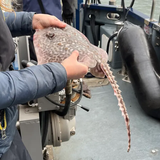 Thornback raySeasonal1 placeSilloth promenade and Tommy LegsOver promenadeAround Mar–Jun
 European sea bassRecorded here1 placeSilloth promenade and Tommy LegsOver promenade
- Small-spotted catsharkRecorded here1 placeSilloth promenade and Tommy LegsOver promenade
- Starry smooth-houndRecorded here1 placeSilloth promenade and Tommy LegsOver promenade
What these strengths mean
- Regular local target
- Fishing sources describe this as a normal local target here, not merely as caught.
- Seasonal
- Well supported, and concentrated in part of the year rather than spread through it.
- Recorded here
- At least one credible public account of this species being caught here. That is all it means.
- How breadth is counted
- A fish documented at six marks is shown as six marks: breadth never raises the strength on its own. A fishery account describes the fishing; a recorded catch reports one specific catch. How evidence is weighed.
Fish documented nearby, not here
Nothing below has been documented at Silloth promenade and Tommy Legs itself. Each one has been documented at a named place on the same ground, and the places are listed with it. Treat this as what the water around here holds rather than as a catch list for this mark.
Widely documented on this ground
Documented at three or more neighbouring places, fished a way this place is also fished. That is a pattern about the ground rather than about any one mark, and it is the closest this site comes to saying you will probably meet a fish somewhere nothing has been written about.
From the shore
- European plaice — documented at Fleet Bay; Maryport harbour and promenade; Brighouse Bay
Also documented at neighbouring places
One or two accounts each, on the ground around here. Enough to know the fish is caught in these waters; not enough to say anything about this place.
From the shore
- Atlantic cod — documented at Maryport harbour and promenade; Balcary Bay
- Pollack — documented at Maryport harbour and promenade; Brighouse Bay
- Bull huss — documented at Balcary Bay
- Conger eel — documented at Balcary Bay
- Saithe — documented at Maryport harbour and promenade
- Tub gurnard — documented at Maryport harbour and promenade
- Turbot — documented at Fleet Bay
How people fish it
Practised here: Sea fishing.
Methods the sources name for this ground. Each one is explained in full on its own page.
- Surfcasting
Casting heavy baited tackle from a beach into surf — a method defined by distance, by tide, and by reading water that all looks the same.
- Ledgering
Fishing a bait on the bottom held by a weight, with no float — the simplest way to fish at distance, in depth, or in wind.
The ground and the water
- The ground
- A cobbled promenade and green above a shore of sand, mud and scattered cobble on the inner Solway, with the beaches south of the town running out over ground that dries a very long way. Shallow, coloured, and among the largest tidal ranges in Britain.
- Exposure
- Open west down the firth; the Scottish shore is visible across it.
- Tide and flow
- Among the biggest ranges in Britain, over ground so flat that the flood outruns a walking pace across it.
Through the year
Thornback ray from spring into early summer, which is the fishery this stretch is known for; the rest through the year.
Safety
Tides and being cut off — Can cause serious injury or death
The flood fills the ground behind an angler before it covers the ground in front, so the water arrives between them and the shore while the position they are standing on is still dry.
What reduces it: Read the tide table before going rather than after arriving, set a leaving time from the tide rather than from the fishing, and identify the exit and how long it takes while the ground is still uncovered.
Rules and access
FishingHQ does not know the current access position here. Shore angling in England is not rod-licensed, but access rights, landowner permission, local authority and harbour byelaws, national and inshore fisheries measures, and site designations all apply and all change. Check the current position with the relevant inshore fisheries and conservation authority, the harbour or local authority, and the landowner before going.
Who holds the answer:
- The Inshore Fisheries and Conservation Authority for the district, which makes and enforces inshore byelaws.
- The Marine Management Organisation, for national recreational sea fishing measures in English waters.
- The local authority and, where one exists, the harbour authority, for access, byelaws and shellfish classification.
- The relevant national fisheries administration for the shore concerned — different bodies apply on the English and Scottish sides of the same firth
- The relevant salmon fishery board or migratory fisheries authority, for anything concerning salmon and sea trout
- The local authority environmental health service, for shellfish harvesting classification and public health closures
- The coastguard, for tidal and safety information, and as the service that will be called if somebody is cut off
- Local clubs and long-established practitioners, whose knowledge of channel positions is operative safety information rather than a courtesy
Nearby fishing
Other publicly documented places within about 40 km, by distance. Positions are approximate public geography and are never exact marks.
- Maryport harbour and promenade — 10–25 km · Harbour wall
- Mersehead Sands — 10–25 km · Beach
- The Annan — 25–40 km · River reach
- Bassenthwaite Lake — 25–40 km · Lake
- The Nith at Dumfries — 25–40 km · River reach
- Workington Rocks — 25–40 km · Rock mark
- Balcary Bay — 25–40 km · Bay
- Derwent Water — 25–40 km · Lake
Sources for this place
- Sea Angler — Bauer Media (Specialist angling publication)Relied on for: Long-running published description of British sea angling practice by region, ground type and named mark.FishingHQ's interpretation of what it saysCitation checked — the work exists and is described correctly
- General angling website restatements of established technique — Various (Credible secondary source)Relied on for: Widely restated public descriptions of which places are conventionally fished and how, recorded as practitioner consensus rather than as scholarship, and not relied on for access, permission or any current rule.Background and mechanism onlyCitation checked — the work exists and is described correctly
- British Sea Fishing: north-west England shore marks — British Sea Fishing (Credible secondary source)Relied on for: Which species are fished for at each named north-west England shore mark, in which season, and with which baits and methods.States this directlyPassage read and verified
How FishingHQ labels evidence is explained in the evidence policy. Last reviewed 2026-08-16.