Canary Islands
Fishing regions · Last reviewed 2026-08-12
Young volcanic islands rising from deep Atlantic water with almost no continental shelf, where deep water is reachable from the rocks and there are no rivers at all.
Safety: cliffs and rock platforms — can cause serious injury or death. 5 more points apply here.
Being listed here is not permission to fish. What that meansClose
Access, fishing rights, seasons, licences, local bylaws and permitted methods vary and can change. Check current access, permission, local regulations, closures and restrictions before you travel or fish. FishingHQ describes what the ground is and names who holds the answer; it does not hold the answer itself.
Find the authority for a jurisdiction · What FishingHQ does and does not cover
The Canaries are volcanic peaks standing in deep ocean off north-west Africa, and three physical facts distinguish their fishing from anywhere in mainland Europe.
THERE IS ALMOST NO SHELF. The islands rise steeply from very deep water, so the shallow ground that surrounds a continental coast barely exists here. Depths of hundreds of metres occur within a short distance of the shore, and in places genuinely deep water is within casting range of a rock platform. That single fact puts species within reach of a shore angler that elsewhere require a long boat trip.
THERE ARE NO RIVERS. No permanent freshwater input means no estuaries, no salinity gradient, no turbid nutrient plume and none of the fishery that depends on them. An angler arriving from Atlantic Europe finds an entire category of ground simply missing.
AND THE WATER IS WARM, CLEAR AND NUTRIENT-POOR. The Canary Current brings cool water down the African coast and there is localised upwelling, but the inshore water is clear and biologically poorer than the same latitude on the African mainland. Clear water means fish that see tackle, which is why light lines and refined presentation matter here more than power.
The fish community is a mix of eastern Atlantic, Mediterranean and subtropical species — parrotfish, bream, groupers, moray, barracuda, amberjack and bonito inshore; tuna, wahoo and billfish in the blue water that starts almost immediately offshore. The islands differ from one another substantially, which is why they are modelled as a group with individual island records rather than as one entity.
What fishing here is like
A subtropical, volcanic, deep-water archipelago where the absence of a shelf and the absence of rivers together produce a fishery unlike anything in mainland Europe. Shore fishing from volcanic rock is the accessible face of it and reaches depths that would require a boat elsewhere. Offshore, blue water begins within a very short distance and supports a substantial big-game charter sector.
The culture is Spanish in its regulatory framework and Atlantic-island in its practice, with a long artisanal small-boat tradition alongside the modern recreational and charter fishery.
What you can target here
One entry per fish, grouped by how you would be fishing — because the answer is a different one from the rocks and from a boat. Each entry says how strongly the sources support it and how much evidence sits behind it. These are documented catches, not a forecast, and none of it is a statement that you may fish any particular ground.
From the shore · 44
- Greater amberjackCharacteristic of this water16 placesLa Restinga, El Hierro, Punta de Teno, Tenerife, Los Hervideros, Lanzarote, Puerto del Carmen harbour, Lanzarote and 12 moreOver bay, cliff coast, cove, harbour wall, headland, reef, rock mark, rock platformAround Jan–Feb, Sept–Dec
- White seabreamRegular local target50 places · 12 fishery accounts · 2 independent sourcesLos Hervideros, Lanzarote, Puerto del Carmen harbour, Lanzarote, Punta de Teno, Tenerife, The Arinaga coast, Gran Canaria and 46 moreOver bay, beach, cliff coast, cove, harbour wall, headland, reef, rock mark, rock platform, surf beachSources name Spinning
- Atlantic horse mackerelRegular local target20 places · 2 fishery accounts · 2 independent sourcesEl Médano, Tenerife, Arrecife and Playa Honda, The Arinaga coast, Gran Canaria, Arrieta and the Jameos coast and 16 moreOver beach, cliff coast, cove, harbour wall, headland, rock platform, surf beachAround May–Oct
- Atlantic mackerelRegular local target6 places · 2 fishery accounts · 2 independent sourcesPuerto del Carmen harbour, Lanzarote, Playa Quemada, Lanzarote, Puerto Calero, Lanzarote, Sardina del Norte, Gran Canaria and 2 moreOver cliff coast, cove, harbour wall, rock platformAround May–Sept
- Mediterranean parrotfishRegular local target27 placesGarachico, Bajamar, Candelaria, The El Sauzal coast and 23 moreOver bay, beach, cliff coast, cove, harbour wall, rock platform
- Salema porgyRegular local target17 placesArrieta and the Jameos coast, Garachico, Bajamar, Candelaria and 13 moreOver bay, beach, cove, harbour wall, rock platform
Also documented from the shore: Common octopus · Atlantic rock crab · Canary black limpet · Macaronesian topshell · Macaronesian white limpet · Canary mussel · Common dentex · Atlantic bonito · Meagre · Ornate wrasse · Canary damselfish · Yellowmouth barracuda · Bogue · Comber · Red porgy · Dusky grouper · Derbio · European squid · Macaronesian sharpnose puffer · Mediterranean moray · Saddled seabream · Atlantic chub mackerel · Atlantic lizardfish · Azores chromis · Black seabream · Butterfly-winged comber · Diamond lizardfish · Greater weever · Guinean puffer · Madeira goby · Madeira rockfish · Planehead filefish · Ringneck blenny · Rockpool blenny · Spotted eagle ray · Striped red mullet · Two-banded seabream · Wide-eyed flounder
From a boat · 10
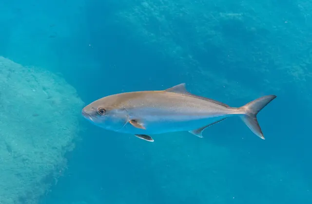 Greater amberjackCharacteristic of this water10 places · 2 fishery accounts · 2 independent sourcesLa Restinga, El Hierro, The Canary offshore grounds, The Arinaga coast, Gran Canaria, Punta Rasca, Tenerife and 6 moreOver cliff coast, harbour wall, headland, reef, rock platform, sea area
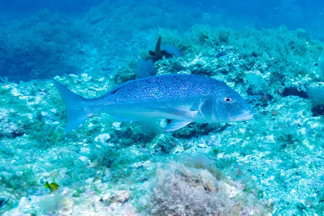 Common dentexRegular local target1 placeLa Restinga, El HierroOver reef
- Atlantic bluefin tunaSeasonal1 place · 1 fishery account · 1 sourceThe Canary offshore groundsOver sea areaAround Apr–Sept
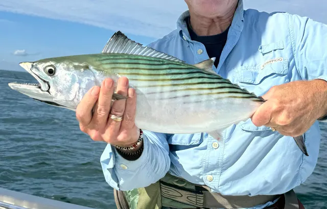 Atlantic bonitoSeasonal2 placesLa Restinga, El Hierro, The Canary offshore groundsOver reef, sea areaAround Jun–Oct
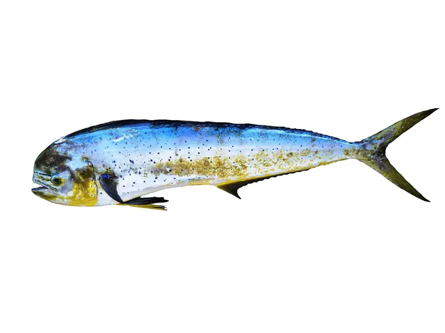 Mahi-mahiSeasonal1 placeThe Canary offshore groundsOver sea areaAround Jul–Oct
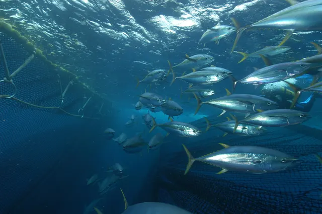 Yellowfin tunaSeasonal1 placeThe Canary offshore groundsOver sea areaAround May–Oct
Also documented from a boat: Wahoo · Wreckfish · Albacore · Dusky grouper
On a charter · 8
- Greater amberjackCharacteristic of this water1 place · 2 fishery accounts · 2 independent sourcesThe Canary offshore groundsOver sea area
- Atlantic bluefin tunaSeasonal1 place · 1 fishery account · 1 sourceThe Canary offshore groundsOver sea areaAround Apr–Sept
- Mahi-mahiSeasonal1 placeThe Canary offshore groundsOver sea areaAround Jul–Oct
- Yellowfin tunaSeasonal1 placeThe Canary offshore groundsOver sea areaAround May–Oct
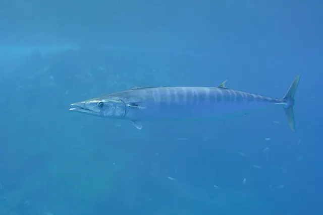 WahooRepeatedly reported1 place · 1 fishery account · 1 sourceThe Canary offshore groundsOver sea areaAround Jul–Nov
- Atlantic blue marlinRepeatedly reported1 placeThe Canary offshore groundsOver sea areaAround Apr–Sept
Also documented on a charter: Atlantic bonito · Albacore
Spearfishing · 4
- Greater amberjackCharacteristic of this water4 places · 2 fishery accounts · 2 independent sourcesThe Canary offshore grounds, Punta de Fuencaliente, La Palma, The south-east coast of La Gomera, The Tamaduste coast, El HierroOver cliff coast, rock platform, sea area
- White seabreamRegular local target6 places · 4 fishery accounts · 2 independent sourcesEl Cotillo, Fuerteventura, Playa del Cabrón, Gran Canaria, Sardina del Norte, Gran Canaria, Punta de Fuencaliente, La Palma and 2 moreOver cliff coast, harbour wall, reef, rock platform
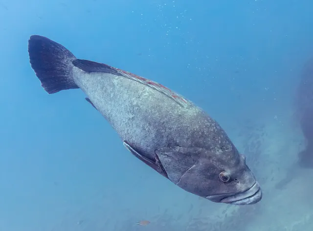 Dusky grouperRecorded here7 placesEl Confital, The La Aldea coast, Ajuy, Playa Quemada, Lanzarote and 3 moreOver cliff coast, cove, rock platform
- Common octopusRecorded here4 placesPlaya del Cabrón, Gran Canaria, Sardina del Norte, Gran Canaria, Punta del Hidalgo, Tenerife, El Cotillo, FuerteventuraOver harbour wall, reef, rock platform
What these strengths mean
- Characteristic of this water
- This water is strongly identified with this species by the sources that cover it.
- Regular local target
- Fishing sources describe this as a normal local target here, not merely as caught.
- Seasonal
- Well supported, and concentrated in part of the year rather than spread through it.
- Repeatedly reported
- Several independent public accounts. Enough to say it happens more than once; not enough to call it a fishery.
- Recorded here
- At least one credible public account of this species being caught here. That is all it means.
- How breadth is counted
- A fish documented at six marks is shown as six marks: breadth never raises the strength on its own. A fishery account describes the fishing; a recorded catch reports one specific catch. How evidence is weighed.
How people fish here
12 methods are recorded on the places documented here, counted from the records themselves rather than from what is practised in the country. Each opens a full guide to the technique.
Float fishing
Recorded at 52 places here, over harbour wall, rock platform, beach, breakwater.
Suspending a bait at a controlled depth beneath a buoyant indicator — the most visual, most controllable and most widely applicable method in angling.
Documented on the same ground: Atlantic horse mackerel, Atlantic mackerel, Common dentex, Common octopus, Greater amberjack, Mediterranean parrotfish.
Ledgering
Recorded at 31 places here, over harbour wall, rock platform, beach, cliff coast.
Fishing a bait on the bottom held by a weight, with no float — the simplest way to fish at distance, in depth, or in wind.
Documented on the same ground: Atlantic horse mackerel, Mediterranean parrotfish, Salema porgy, White seabream, Meagre, Greater amberjack.
Light rock fishing
Recorded at 31 places here, over harbour wall, rock platform, breakwater, cove.
Ultralight lure fishing from the shore with tackle rated in single grams — a discipline that catches the fish everybody else steps over, and one FishingHQ held every component of and had never named.
Documented on the same ground: Atlantic horse mackerel, Mediterranean parrotfish, Salema porgy, White seabream, Meagre, Greater amberjack.
Spinning
Recorded at 27 places here, over rock platform, cliff coast, cove, headland.
Casting an artificial lure and retrieving it so that it moves like something alive — the most direct form of lure fishing.
Documented on the same ground: Common dentex, Common octopus, Greater amberjack, Mediterranean parrotfish, White seabream, Atlantic bonito.
Shore diving
Recorded at 13 places here, over harbour wall, rock platform, cliff coast, headland.
Entering and leaving the water from land under your own power — the most accessible spearfishing and the one where the entry and exit are the dangerous part.
Documented on the same ground: Greater amberjack, Atlantic mackerel, Common dentex, Common octopus, Mediterranean parrotfish, White seabream.
Jigging
Recorded at 10 places here, over harbour wall, cliff coast, reef, sea area.
Working a weighted lure with a rising-and-falling motion, usually vertically, so it behaves like a wounded or fleeing baitfish.
Documented on the same ground: Greater amberjack, Common dentex, Mediterranean parrotfish, White seabream, Atlantic bluefin tuna, Atlantic bonito.
Kayak fishing
Recorded at 5 places here, over rock platform, breakwater, harbour wall, surf beach.
A platform rather than a technique: quiet, shallow-draught access to water no other craft reaches, bought at the price of exposure, and a discipline where the decision not to launch is part of the skill.
Documented on the same ground: Atlantic mackerel, Common octopus, White seabream, Canary damselfish, Greater amberjack, Ornate wrasse.
Trolling
Recorded at 5 places here, over harbour wall, reef, sea area.
Towing lures or baits behind a moving boat to cover large volumes of water and locate scattered fish.
Documented on the same ground: Greater amberjack, Common dentex, Atlantic bluefin tuna, Atlantic bonito, Mahi-mahi, Yellowfin tuna.
Surfcasting
Recorded at 4 places here, over beach, harbour wall, surf beach.
Casting heavy baited tackle from a beach into surf — a method defined by distance, by tide, and by reading water that all looks the same.
Documented on the same ground: Mediterranean parrotfish, White seabream, Meagre, Bogue, Salema porgy, Striped red mullet.
3 further methods are recorded at one or two places each: Big-game fishing, Boat diving, Eging.
These are the methods documented at the places FishingHQ holds here. A species listed beside a method is documented on the same ground, which is not the same as being taken that way — where a source establishes the method a fish was caught on, it is stated on that place’s own page. All fishing methods.
The fishing year here
The months the records under this area actually name, tightest season first. This is “observed in these months” rather than a season: a species whose months nobody recorded is not listed, because a gap in the evidence is not a year-round fishery.
- ComberMay to May
- Ornate wrasseMay to May
- Canary damselfishMay to May
- Macaronesian sharpnose pufferMay to May
- Mediterranean moraySeptember to September
- Saddled seabreamMay to May
- Atlantic chub mackerelMay to May
- Atlantic lizardfishMay to May
- Azores chromisMay to May
- Black seabreamMay to May
- Butterfly-winged comberMay to May
- Diamond lizardfishMay to May
Areas within this one
2 coasts, island groups and systems inside this area have fishing guides of their own.
Lanzarote
16 documented places
The driest, windiest and lowest of the Canaries, and the only one sharing a genuine shallow shelf — which gives it ground the rest of the archipelago simply does not have.
Documented here: Atlantic mackerel, White seabream, Atlantic horse mackerel, Mediterranean parrotfish, Salema porgy
Fished by: float fishing, spinning, light rock fishing, ledgering
Tenerife
18 documented places
The deepest water closest to shore in the archipelago, a mountain that makes its own weather, and the centre of the Canaries' blue-water fishery.
Documented here: White seabream, Atlantic horse mackerel, Mediterranean parrotfish, Greater amberjack, Common dentex
Fished by: float fishing, spinning, ledgering, light rock fishing
What dominates
Shore fishing from volcanic rock platforms for bream, parrotfish, moray and barracuda, with light-line techniques dominating because of the water clarity. Spinning and popping from the rocks for amberjack and bonito, which is one of the few places in Europe where genuine pelagic species are a shore proposition. Offshore trolling and big-game fishing over the deep water, which starts within a few miles. Spearfishing is practised and is regulated, with restrictions that differ between islands and between protected areas.
The water available
Volcanic rock coast — lava platform, boulder, cliff and blowhole — dominating the shoreline. Black and pale sand beaches formed from volcanic and shell material. Almost no shelf: steep drop-offs close inshore, with hundreds of metres of depth within a short distance. Some seagrass on sheltered sand. No estuaries and no permanent rivers anywhere in the archipelago.
How the rules are structured
The islands fall under Spanish and European fisheries frameworks with regional Canarian administration, and recreational sea fishing generally requires a licence obtained from the regional authority. Beyond that, the framework includes minimum sizes, species prohibitions, restrictions on spearfishing including where and with what it may be practised, and a network of marine protected areas with their own zoning. Several islands and specific areas carry additional local rules. None of that should be taken from this page as a current position: establish licensing, protected-area boundaries and any spearfishing restriction with the Canarian regional authority before fishing. FishingHQ does not state what any current rule is.
Who to ask
- The regional Canarian government fisheries administration, for recreational licences, sizes and species rules
- The Spanish national maritime and fisheries authorities, for offshore and vessel matters
- The managing authority of any marine protected area or reserve, whose zoning governs what is permitted inside it
- Local dive centres, charter operators and clubs, for current practice and access on individual islands
Words you will meet
- Charco
- A natural rock pool or pocket of water in the lava coast, sometimes large enough to be a swimming and fishing feature in its own right.
- Vieja
- The parrotfish Sparisoma cretense, one of the most characteristic and most valued inshore food fish of the islands.
- Malpaís
- Rough, broken lava ground. As a coastal description it means access that is hard on footwear and unforgiving of a fall.
- Cabildo
- The island-level government. Relevant because rules and access can differ between islands within the same archipelago and the cabildo is frequently where island-specific answers sit.
Conditions and hazards
The volcanic rock coast is the principal hazard and it is unlike granite or limestone platform elsewhere. Lava is abrasive, sharp, frequently undercut and full of holes and blowholes, and a fall onto it causes worse injuries than a fall onto smoother rock. Footwear matters more than usual.
Atlantic swell arrives on the northern and western coasts with no local warning, and because the shelf is absent that swell reaches the rocks with very little energy lost. Waves at exposed platforms are larger and less predictable than the wind would suggest, and people are washed from rock platforms here regularly.
Deep water close inshore means a person entering the water is quickly out of their depth and frequently in current. Sun and dehydration are constant and underestimated at this latitude.
A tourist archipelago with an old inshore fishery beneath it
Canarian fishing culture has an old artisanal layer and a very large modern visitor layer, and the two share a small amount of water.
THE ARTISANAL FISHERY IS ANCIENT AND SMALL-SCALE. Small boats working traps, lines and nets out of many small harbours for parrotfish, seabream, grouper and cephalopods is the continuing local pattern, organised through fishermen's guilds, and the volcanic coastline with almost no shelf means it has always been a fishery conducted close to deep water.
THE TUNA FISHERY IS THE ARCHIPELAGO'S COMMERCIAL SIGNATURE. Pole-and-line and live-bait fishing for skipjack and bigeye tuna is a long-standing Canarian method, and it is the same selective approach the Maldives page describes, operating in the eastern Atlantic.
SHORE ANGLING IS WIDELY PRACTISED, from rock and harbour into deep water, and it is a local activity as much as a visitor one.
THE VISITOR ECONOMY IS DOMINANT and it brings charter fishing, dive tourism and a great deal of coastal development with it, concentrated on particular islands and coasts.
CEPHALOPODS AND SHELLFISH ARE ORDINARY FOOD AND AN ORDINARY CATCH, and the local kitchen reflects an Atlantic-African rather than a European mainland fish culture.
THE ISLANDS ARE NOT INTERCHANGEABLE, and locals are quick to say so. The eastern islands are dry, low and wind-exposed; the western ones are high, wet and steep; and the fishing differs accordingly.
AND THE SEA IS RESPECTED. A coast where the shelf is negligible and Atlantic swell arrives unimpeded produces a genuine local caution about rock fishing that a visitor should adopt.
What experienced anglers do — why, and the sources (2)
Widely and independently recommended by experienced anglers and specialist sources. This is real angling knowledge, not proof: controlled evidence for it is limited, and FishingHQ records it as convention rather than as a demonstrated effect.
- General angling website restatements of established technique — Various (Credible secondary source)Relied on for: Widely restated practice associating this discipline or technique with this place, recorded as practitioner consensus rather than as tested fact.Background and mechanism onlyCitation checked — the work exists and is described correctly
- Fishers' Craft and Lettered Art: Tracts on Fishing from the End of the Middle Ages — University of Toronto Press, 1997 (Scientific literature)Relied on for: That fishing traditions develop around the water and fish available to them, and the historical method of reading such traditions from their documentary record.States this directlyCitation checked — the work exists and is described correctly
Fishing where the bottom falls away immediately
Every Canarian discipline follows from one fact: there is essentially no continental shelf, and deep water starts at the shore.
SHORE FISHING INTO DEEP WATER is the characteristic practice. Volcanic rock dropping steeply into blue water means that a shore angler is fishing depths that would require a boat almost anywhere in Europe, and the tackle and methods reflect that — float fishing at depth, heavy bottom fishing, and lure work for pelagic species from the rocks.
BOAT AND CHARTER FISHING REACHES BLUE WATER IN MINUTES. The absence of a shelf means big-game grounds are a short run offshore, which is the archipelago's principal attraction for visiting anglers and the basis of its charter industry.
POLE-AND-LINE TUNA FISHING is the traditional commercial method, using live bait to raise the school and taking fish one at a time, and it survives here for the same reasons it survives in the Maldives.
TRAP AND LINE FISHING IS THE ARTISANAL DISCIPLINE, worked from small boats over hard ground close to shore.
SPEARFISHING IS PRACTISED ON THE ROCKY COAST in clear warm water and is separately licensed under the Spanish framework.
EGING AND CEPHALOPOD FISHING is ordinary practice from harbours and rocks after dark.
SHORE GATHERING FOR LIMPETS AND SHELLFISH has a long local history and is now constrained by conservation rules, because the intertidal here is small in area and has been heavily used.
AND WHAT DOES NOT EXIST IS A BEACH FISHERY OF THE ATLANTIC KIND. There is very little sand, almost no estuary and no river, so the surfcasting tradition of the Iberian mainland has no ground to happen on.
What experienced anglers do — why, and the sources (2)
Widely and independently recommended by experienced anglers and specialist sources. This is real angling knowledge, not proof: controlled evidence for it is limited, and FishingHQ records it as convention rather than as a demonstrated effect.
- General angling website restatements of established technique — Various (Credible secondary source)Relied on for: Widely restated practice associating this discipline or technique with this place, recorded as practitioner consensus rather than as tested fact.Background and mechanism onlyCitation checked — the work exists and is described correctly
- Fishers' Craft and Lettered Art: Tracts on Fishing from the End of the Middle Ages — University of Toronto Press, 1997 (Scientific literature)Relied on for: That fishing traditions develop around the water and fish available to them, and the historical method of reading such traditions from their documentary record.States this directlyCitation checked — the work exists and is described correctly
Vieja, cherne and the words of an Atlantic-African fauna
The Canarian fish vocabulary is Spanish with strong local specificity, and the names do not map onto mainland Spanish usage.
VIEJA NAMES THE PARROTFISH, the archipelago's most emblematic inshore food fish and one whose local importance a visitor would not guess from a European fish list. It is a herbivorous reef fish, it is central to the local kitchen, and it is a good indicator that this is an Atlantic-African fauna rather than a European one.
CHERNE NAMES THE WRECKFISH AND RELATED DEEP GROUPERS, taken from the deep water that begins close to shore, and it is a prestige fish locally.
SAMA NAMES THE DENTEX-TYPE SEABREAMS of the deeper rock, and the seabream group generally has a rich Canarian vocabulary.
LAPA NAMES THE LIMPET, gathered from the intertidal for as long as people have lived here and now subject to conservation constraint because the resource is small and the pressure long-standing.
CHARCO NAMES A ROCK POOL OR NATURAL SEAWATER POOL in the lava, and these are a defining feature of the coastline both as habitat and as the place people swim, because beaches are scarce.
CALIMA NAMES THE SAHARAN DUST EVENT that periodically covers the islands in haze and fine dust carried on easterly winds. It affects visibility, air quality and comfort, and it is a genuine planning consideration.
AND MALPAÍS NAMES THE ROUGH LAVA GROUND that much of the coastline consists of — broken, sharp, difficult to walk on and unforgiving of a fall, which is a practical fact for any shore angler here.
What experienced anglers do — why, and the sources (2)
Widely and independently recommended by experienced anglers and specialist sources. This is real angling knowledge, not proof: controlled evidence for it is limited, and FishingHQ records it as convention rather than as a demonstrated effect.
- General angling website restatements of established technique — Various (Credible secondary source)Relied on for: Widely restated practice associating this discipline or technique with this place, recorded as practitioner consensus rather than as tested fact.Background and mechanism onlyCitation checked — the work exists and is described correctly
- Fishers' Craft and Lettered Art: Tracts on Fishing from the End of the Middle Ages — University of Toronto Press, 1997 (Scientific literature)Relied on for: That fishing traditions develop around the water and fish available to them, and the historical method of reading such traditions from their documentary record.States this directlyCitation checked — the work exists and is described correctly
Aboriginal shell middens, tuna canneries and a tourism economy
The Canaries' fishing history runs from a pre-conquest indigenous fishery to a modern service economy in a comparatively short span.
THE PRE-CONQUEST POPULATION FISHED AND GATHERED EXTENSIVELY. Archaeological deposits across the islands contain fish bone, limpet and shellfish remains in quantity, showing systematic use of the intertidal and inshore resource before European contact, and stone tidal traps built on the shore survive in places.
THE ISLANDS BECAME AN ATLANTIC WAYPOINT after the fifteenth century, provisioning ships on the route to the Americas, and the fishery served that traffic as well as the local population.
THE SAHARAN BANK FISHERY WAS THE ECONOMIC MAINSTAY for a long period. Canarian fleets fished the highly productive upwelling waters off the north-west African coast, landing and processing in the islands, and the loss of access to those grounds in the later twentieth century was a substantial economic blow.
TUNA AND SARDINE CANNING supported an industry in the islands built on both local and African-bank catches.
TOURISM TRANSFORMED THE ECONOMY FROM THE 1960s, and the transformation was as complete here as in the Balearics. Fishing became a minor sector, coastal development altered the shore, and charter fishing became a visitor service.
BIG-GAME FISHING DEVELOPED A REPUTATION, particularly for blue marlin off some of the islands, on the strength of deep water close to shore.
AND CONSERVATION ARRIVED LATE AND SUBSTANTIALLY, with marine reserves, a national park network on land and sea, and constraints on intertidal gathering reflecting how heavily used a small resource had become.
Official guidance — why, and the sources (2)
Stated by a fisheries authority, scientific institute or recognised angling body. Authoritative, but summarising rather than demonstrating.
- Fishers' Craft and Lettered Art: Tracts on Fishing from the End of the Middle Ages — University of Toronto Press, 1997 (Scientific literature)Relied on for: The historical development of fishing practice and its transmission, and the method of reading a fishing tradition from its documentary record.States this directlyCitation checked — the work exists and is described correctly
- Code of Conduct for Responsible Fisheries — Food and Agriculture Organization of the United Nations, Rome, 1995 (Standards body)Relied on for: Principles for fisheries management including the treatment of traditional, small-scale and shared fisheries, against which historical arrangements can be read.Background and mechanism onlyCitation checked — the work exists and is described correctly
Spanish framework, regional administration, island reserves
The Canaries are an autonomous community of Spain with substantial fisheries competence, and the structure follows that.
THE REGIONAL GOVERNMENT ADMINISTERS INSHORE FISHERIES, within the Spanish national and European framework, and it is the body that issues recreational licences and sets local measures.
RECREATIONAL FISHING REQUIRES A LICENCE with separate categories for shore, boat and underwater fishing, and bag limits, minimum sizes and species restrictions attach to it. Visitors from unlicensed jurisdictions need to arrange this in advance.
UNDERWATER FISHING IS SEPARATELY LICENSED AND CONDITIONED, with equipment restrictions and a prohibition on combining it with breathing apparatus.
MARINE RESERVES EXIST AROUND SEVERAL ISLANDS with graduated protection zones, and their boundaries decide what may happen more directly than any general rule.
INTERTIDAL GATHERING IS CONSTRAINED. Limpet and shellfish collection has been restricted because a small intertidal resource has been used intensively for a very long time, and closed periods and size limits apply.
THE ARCHIPELAGO IS AN OUTERMOST REGION OF THE EUROPEAN UNION, which affects how European fisheries measures apply here and gives some scope for regionally adapted rules.
CETACEAN WATCHING IS SEPARATELY REGULATED and is economically significant, with rules on approach distances that affect boat operation generally.
AND FISHINGHQ DOES NOT STATE WHAT ANY OF THIS CURRENTLY PERMITS. The regional fisheries directorate and the reserve managing bodies are the durable answer.
Official guidance — why, and the sources (2)
Stated by a fisheries authority, scientific institute or recognised angling body. Authoritative, but summarising rather than demonstrating.
- Code of Conduct for Responsible Fisheries — Food and Agriculture Organization of the United Nations, Rome, 1995 (Standards body)Relied on for: Principles for the management of fisheries, including licensing, closed seasons, size limits and the treatment of small-scale and shared stocks.States this directlyCitation checked — the work exists and is described correctly
- Good Fish Guide — Marine Conservation Society (Conservation authority)Relied on for: Assessment of fisheries and the management measures applied to them, including the instruments used and their purpose.Background and mechanism onlyCitation checked — the work exists and is described correctly
A subtropical year with no real winter and a wind that never stops
The Canarian fishing calendar is set by water temperature at the margins and by wind almost all the time.
THERE IS NO CLOSED BIOLOGICAL SEASON IN THE NORTHERN EUROPEAN SENSE. Water temperature varies within a few degrees across the year, so inshore species are available continuously and there is no thermal shutdown.
THE TRADE WINDS ARE THE CONSTANT. Persistent north-easterlies blow for most of the year, and they decide which coast of which island is fishable on a given day. The northern and eastern coasts are exposed; the southern and western ones are in the lee. Local knowledge here is largely knowledge of where to go in a given wind.
SUMMER IS THE BIG-GAME SEASON. Warmer water brings blue marlin, tuna and other blue-water species closer, and the charter fishery concentrates in the warmer months.
WINTER BRINGS ATLANTIC SWELL. Depressions far to the north send long-period ground swell onto the northern coasts, and it arrives with no local weather to explain it. That is the dangerous condition for shore fishing and it is a seasonal one.
THE CALIMA IS AN EPISODIC RATHER THAN SEASONAL EVENT, though it clusters in certain months: Saharan dust carried west on easterly winds reduces visibility, raises temperature and affects comfort and air quality.
CEPHALOPOD AVAILABILITY SHIFTS WITH WATER TEMPERATURE rather than with a calendar, and cuttlefish come shallow to spawn in the warmer part of the year.
AND THE PRACTICAL POINT FOR A VISITOR is that the archipelago is fishable year-round and the question is never whether but where — which is the opposite of most of the fisheries on FishingHQ.
Backed by research — why, and the sources (2)
Supported by peer-reviewed research or fisheries science. The sources are listed and can be checked.
- FAO Species Identification Guides for Fishery Purposes and the FAO Species Catalogues — Food and Agriculture Organization of the United Nations (Scientific institute)Relied on for: Distribution, habitat and depth accounts for the species of the eastern central Atlantic in the FAO regional identification guides.States this directlyCitation checked — the work exists and is described correctly
- FishBase: a global information system on fishes — Froese, R. and D. Pauly, eds. — FishBase Consortium (Scientific institute)Relied on for: Distribution, habitat association and depth range recorded for the species.States this directlyPassage read and verified
No shelf and no rivers: two absences that define the fishing
Most fishing coasts are defined by what they have. These are defined by two things they do not.
THERE IS ALMOST NO CONTINENTAL SHELF. The islands are volcanic peaks standing in deep ocean, rising steeply from thousands of metres. The gently shelving shallow ground that surrounds a continental coast barely exists here — depths of hundreds of metres occur within a short distance of the shore, and in places genuinely deep water lies within casting range of a rock platform.
That single fact rearranges everything. Species that elsewhere require a boat trip are a shore proposition. Amberjack, bonito and other genuine pelagics can be reached from the rocks, which is true almost nowhere in Europe. The blue-water fishery starts within a few miles rather than over the horizon. And there is no broad shallow nursery ground of the kind that supports the flatfish and juvenile-fish communities of northern Europe.
THERE ARE NO RIVERS. No permanent freshwater input means no estuaries, no salinity gradient, no turbid nutrient plume, and none of the fishery that depends on them. An angler arriving from Atlantic Europe finds an entire category of ground simply missing — and with it the bass, mullet and flounder fishing that ground supports.
WHAT IS PRESENT INSTEAD is volcanic rock coast: lava platform, boulder, cliff, blowhole and the natural rock pools called charcos. Beaches are black or pale depending on whether the sand is volcanic or shell-derived. Some seagrass grows on sheltered sand.
AND THE WATER IS WARM, CLEAR AND NUTRIENT-POOR. The Canary Current brings cooler water down the African coast and there is localised upwelling, but inshore the water is clear and biologically poorer than the African mainland at the same latitude. Clear water means fish that inspect tackle, which is why light lines and refined presentation matter here far more than power does.
THE HAZARD FOLLOWS FROM THE FIRST ABSENCE. With no shelf to dissipate it, Atlantic swell reaches the lava platforms having lost very little energy. Waves are larger and less predictable than the wind suggests, and people are washed from rock platforms here regularly.
Backed by research — why, and the sources (2)
Supported by peer-reviewed research or fisheries science. The sources are listed and can be checked.
- General angling website restatements of established technique — Various (Credible secondary source)Relied on for: Widely restated local fishing character and practice for these waters, recorded as practitioner consensus rather than as tested fact.Background and mechanism onlyCitation checked — the work exists and is described correctly
- RNLI water safety guidance: cold water shock and Float to Live — Royal National Lifeboat Institution (Water-safety or diver-training authority)Relied on for: That tidal streams, swell from distant weather and cold-water immersion are the principal hazards to shore and small-craft users on exposed coasts.States this directlyPassage read and verified
An Atlantic, Mediterranean and subtropical list in the same water
The Canaries sit where three faunal influences overlap, and the species list reflects it in a way no mainland European coast does.
THE RESIDENT INSHORE FISH are largely eastern Atlantic and Mediterranean in character: sea breams of several species, wrasse, and the parrotfish known locally as vieja, which is one of the most characteristic and most valued food fish of the islands. Moray eels are abundant in the lava ground and are a genuine handling hazard rather than a curiosity. Groupers occur and have been reduced by fishing pressure in accessible areas.
THE PELAGIC COMPONENT is what makes the islands unusual. Amberjack, bonito, barracuda and various tuna species come within reach of the shore because the deep water does, and shore-based spinning and popping for genuine pelagics is a mainstream discipline here rather than an eccentricity. Offshore, the blue water holds tuna, wahoo and billfish and supports a substantial charter sector.
WHAT IS ABSENT is the northern European inshore list. No bass fishery of consequence, no estuarine species, no flatfish fishery of the kind the sandy shelf coasts of Europe support — because the ground those species need is not here.
AND THE SUBTROPICAL ELEMENT introduces species most European anglers will not have handled, some of which require identification before touching. Moray dentition, scorpionfish spines and several venomous species occur on ground that is fished casually from the rocks.
A CAUTION ON CONSUMPTION. Some larger reef and pelagic predators in subtropical Atlantic waters have been associated with ciguatera, and the risk varies by locality and by fish size in ways no general rule captures. That is a matter for current local health advice rather than for a general statement here.
AND THE SPECIES RULES DIFFER FROM THE MAINLAND. Protected species, minimum sizes and restrictions on what may be taken by which method are set regionally and vary between islands and inside marine protected areas. Establish the current position with the Canarian regional authority before keeping anything.
Backed by research — why, and the sources (2)
Supported by peer-reviewed research or fisheries science. The sources are listed and can be checked.
- General angling website restatements of established technique — Various (Credible secondary source)Relied on for: Widely restated local fishing character and practice for these waters, recorded as practitioner consensus rather than as tested fact.Background and mechanism onlyCitation checked — the work exists and is described correctly
- RNLI water safety guidance: cold water shock and Float to Live — Royal National Lifeboat Institution (Water-safety or diver-training authority)Relied on for: That tidal streams, swell from distant weather and cold-water immersion are the principal hazards to shore and small-craft users on exposed coasts.States this directlyPassage read and verified
Lava is not rock, and the coast will not let you climb back out
Anglers arriving here bring a mental model of a rock coast built on granite, limestone or sandstone, and lava does not behave like any of them. That mismatch, on a holiday coast where the danger is not expected at all, is the shape of the problem.
WHAT IS PHYSICALLY DIFFERENT ABOUT LAVA. It is abrasive rather than smooth, so a fall grazes and lacerates where the same fall on worn granite would bruise. It is sharp-edged, frequently in the form of broken plates and spines. It is holed and undercut, so the surface is full of ankle-sized voids that are invisible under water or in poor light. And it has blowholes: passages connecting the sea to the platform surface through which water is forced upward with real violence, in places a long way back from the water's edge. A person walking a lava platform is walking a surface that can be structurally unsound underfoot and can vent from beneath.
WHICH MEANS THE FOOTWEAR DECISION IS NOT COSMETIC HERE. Stiff, gripping, ankle-supporting boots are doing work on this ground that trainers cannot do, and most of the injuries are ankles turned in holes rather than anything dramatic.
THE SWELL ARRIVES WITH ALMOST NOTHING TAKEN OUT OF IT. These islands sit in deep Atlantic water with no continental shelf in front of them, and a shelf is what normally bleeds energy out of an approaching swell before it reaches a coast. Without one, waves reach exposed northern and western platforms carrying close to their full ocean energy, and they are larger and less predictable than the local wind suggests. People are washed off regularly.
AND THEN THE COAST REFUSES THE RECOVERY. This is the part that turns immersion into fatality and it is specific to this geology: there is no shelving margin, the water at the platform edge is immediately deep, and the rock a person tries to climb back onto is a vertical or undercut abrasive face with surge running up and down it. Getting out unaided is frequently not possible even for somebody uninjured, and a person who has been dragged once across lava is not uninjured.
THE CONTEXT MAKES IT WORSE RATHER THAN BETTER. This is a destination coast: a large proportion of the people on those platforms are visitors, fishing unfamiliar ground, without local knowledge of which ledges are workable in which swell, and frequently alone.
WHAT ACTUALLY HELPS. Check swell — height, period and direction — rather than wind, and treat the northern and western coasts as different propositions from the southern and eastern on any given day. Watch a platform through several full sets from high ground before going down onto it, and pick a position with an escape route upward rather than only a place to stand. Wear a buoyancy aid on the rocks. Do not fish exposed platforms alone. Wear boots. And take the sun seriously: ultraviolet is high all year, it reflects off pale ground and water, and long sessions on shadeless rock produce dehydration that degrades judgement before it produces symptoms.
Official guidance — why, and the sources (3)
Stated by a fisheries authority, scientific institute or recognised angling body. Authoritative, but summarising rather than demonstrating.
- Rock fishing safety and the declared lifejacket areas of New South Wales — NSW Department of Primary Industries and Surf Life Saving NSW (Water-safety or diver-training authority)Relied on for: Rock-platform fishing hazards, the mechanism by which anglers are swept from platforms by sets rather than by average conditions, the fatality record that produced the response, and the measures that address it including mandatory lifejacket areas.States this directlyCitation checked — the work exists and is described correctly
- RNLI water safety guidance: cold water shock and Float to Live — Royal National Lifeboat Institution (Water-safety or diver-training authority)Relied on for: Cold water shock and the immersion response, and water-safety guidance for shore anglers and small-craft users.States this directlyPassage read and verified
- General angling website restatements of established technique — Various (Credible secondary source)Relied on for: Widely restated descriptions of regional angling practice and of the conditions under which it is undertaken, recorded as practitioner consensus rather than as scholarship.Background and mechanism onlyCitation checked — the work exists and is described correctly
Places within this area
Publicly documented fishing geography. FishingHQ describes what the ground is; it does not say whether you may fish it, and every one of these sends that question to the body that holds the answer. Browse every place in this part of the world.
Who to ask before fishing any of these
FishingHQ does not know the current access position here. The Canary Islands are an autonomous community licensing their own recreational sea, boat and underwater fishing, separately from mainland Spain, and the archipelago carries marine reserves in which fishing and diving are restricted or prohibited on boundaries a visitor cannot see from the shore. Measures change. Check the current position with the Canarian government's fisheries administration before going.
La Restinga, El Hierro
Reef · Salt water
A lava-flow coast at the southern tip of the westernmost Canary island, with volcanic reef, arches and boulder falls close inshore and the seabed dropping into very deep water a short distance out.
In the lee of the island and famously calm — the sea here is named for it — which is why the diving and small-boat fishing concentrate at this point rather than anywhere else on the island.
Particular to this ground: drowning and immersion, boat traffic and being seen.
Severe hazards of Canary Islands apply here: cliffs and rock platforms.
Particular to this water: This ground lies in or beside a marine protected area whose zoning constrains fishing, diving, anchoring and collection independently of any licence, with rules that differ between zones and boundaries that are not visible from the water. Underwater fishing is licensed and regulated separately from rod fishing throughout this jurisdiction, with its own age, equipment and distance requirements, and holding a rod licence is not permission to spearfish.
Gran Canaria
Island · Salt water
A near-circular volcanic island with a high interior, a dry rocky south and east coast, a wetter north coast of cliff and cut platform, and harbour and mole structure at almost every coastal town.
The north and north-east take the prevailing trade wind and the Atlantic swell with it; the south and south-west sit in the island's lee and are fishable when the north is not.
Severe hazards of Canary Islands apply here: cliffs and rock platforms.
Particular to this water: A Canary recreational fishing licence is required, separately for shore, boat and underwater fishing. FishingHQ does not hold the current requirements — check with the Canary regional fisheries authority before fishing.
Fuerteventura
Island · Salt water
The longest and lowest of the islands, with extensive sand beaches on both coasts, long stretches of low cut rock between them, and working harbours strung from El Cotillo in the north to Morro Jable in the south.
Long and narrow across the trade wind, so one coast is almost always sheltered while the other is not — the reason the island's fishing moves side to side with the weather rather than stopping.
Severe hazards of Canary Islands apply here: cliffs and rock platforms.
Particular to this water: A Canary recreational fishing licence is required, separately for shore, boat and underwater fishing. FishingHQ does not hold the current requirements — check with the Canary regional fisheries authority before fishing.
La Palma
Island · Salt water
A steep young volcanic island with very little level coast: cliff, boulder and black shingle for most of its circumference, with the southern point at Fuencaliente the most consistently used shore ground.
Exposed on every side, with the west coast taking Atlantic swell with no shelter at all.
Severe hazards of Canary Islands apply here: cliffs and rock platforms.
Particular to this water: A Canary recreational fishing licence is required, separately for shore, boat and underwater fishing. FishingHQ does not hold the current requirements — check with the Canary regional fisheries authority before fishing.
La Gomera
Island · Salt water
A small, steep, deeply eroded island whose coast is almost entirely cliff and boulder, with a handful of harbours in the valley mouths and very little walkable shore between them.
The north and west take the swell; the south-east coast around Valle Gran Rey and Playa de Santiago is the sheltered side and carries most of the activity.
Severe hazards of Canary Islands apply here: cliffs and rock platforms.
Particular to this water: A Canary recreational fishing licence is required, separately for shore, boat and underwater fishing. FishingHQ does not hold the current requirements — check with the Canary regional fisheries authority before fishing.
El Hierro
Island · Salt water
The smallest and most westerly of the inhabited islands, a young volcanic cone with a cliff-bound coast, lava platforms at sea level and almost no sand anywhere.
Fully exposed Atlantic on all sides, with the north coast taking the worst of it.
Severe hazards of Canary Islands apply here: cliffs and rock platforms.
Particular to this water: A Canary recreational fishing licence is required, separately for shore, boat and underwater fishing. This ground also lies in or beside a marine reserve whose restrictions are ZONED rather than uniform, and the zoning changes. FishingHQ holds neither the licence requirements nor the reserve rules — establish both with the Canary regional fisheries authority and the reserve authority before fishing.
La Graciosa
Island · Salt water
A small low sand-and-lava island off northern Lanzarote, with no surfaced roads, a single settlement at Caleta de Sebo and a shore of beach, low rock and shallow sand flats. Underwater the reserve authorities describe predominantly rocky, abrupt ground with abundant caves, cracks and tunnels, on a broad marine platform they call exceptional in the archipelago, with seagrass meadows of Cymodocea nodosa — sebadales — and, in places, algal cover reduced by grazing sea urchins.
The channel between the island and Lanzarote's northern cliffs runs hard, and the north-facing shore takes the full trade-wind sea.
Severe hazards of Canary Islands apply here: cliffs and rock platforms.
Particular to this water: THE ISLAND LIES INSIDE SPAIN'S LARGEST MARINE RESERVE, and the bodies that run it publish what that means. FISHING WITH A ROD FROM THE SHORE REQUIRES NO AUTHORISATION, in the ministry's own words. From a boat it does, with distances: rod or handline no less than two miles from the integral reserve and 500 m off Roque Oeste and Montaña Clara; trolling two miles out, migratory pelagics only. A ONE-MILE CIRCLE CENTRED ON ROQUE DEL ESTE IS THE INTEGRAL RESERVE, closed to all fishing. A Canary licence is needed throughout, and the reserve keeps an information office at Caleta de Sebo.
The Canary offshore grounds
Sea area · Salt water
The deep water between and around the islands. There is no continental shelf here: the ground falls from the island slopes into abyssal depth, and the fishery is a blue-water one worked over that drop rather than over any bank.
Open Atlantic, worked from the sheltered southern and western coasts of the larger islands.
Particular to this ground: boat traffic and being seen, sun, dehydration and fatigue.
Severe hazards of Canary Islands apply here: cliffs and rock platforms.
Particular to this water: A Canary recreational fishing licence is required, separately for shore, boat and underwater fishing. FishingHQ does not hold the current requirements — check with the Canary regional fisheries authority before fishing. Offshore fishing here is overwhelmingly done from licensed charter boats, and the operator's own permissions, quotas and species restrictions apply on top of the angler's licence. Several of the species listed are subject to size, quota or seasonal measures that change.
Safety
Cliffs and rock platforms — Can cause serious injury or death
Atlantic swell reaches the northern and western coasts with little energy lost, because there is no shelf to dissipate it. Waves at exposed lava platforms are larger and less predictable than the wind suggests, and people are washed off regularly.
What reduces it: Check swell rather than wind. Watch any platform for a sustained period before committing to it. Never fish a position you could not leave immediately, and treat undercut and blowhole ground as unsafe regardless of conditions.
Slips, trips and falls — Can cause injury needing treatment
Lava rock is abrasive, sharp-edged, undercut and holed. Falls produce worse lacerations and abrasions than falls onto smoother rock, and ankles are turned in the holes.
What reduces it: Substantial footwear with a stiff sole and good grip. Move deliberately and test ground. Do not carry equipment in both hands across broken lava.
Sun, dehydration and fatigue — Can cause injury needing treatment
High ultraviolet levels year-round, reflection off pale sand and water, and long sessions on exposed rock with no shade. Dehydration degrades judgement before it produces symptoms.
What reduces it: Cover up rather than relying on sunscreen alone, wear polarised glasses and a hat, and drink steadily through the session rather than when thirsty.
Precautions that always apply here
- Check the tide before you go and know your exit route. Being cut off is the commonest way a shore session becomes a rescue.
- Tell somebody where you are going and when you expect to be back.
- Carry a charged phone in a waterproof case, or another means of calling for help.
Further safety reading
- Rock platform and cliff safety — No continental shelf means Atlantic swell reaches the lava platforms having lost very little energy, so waves are larger and less predictable than the wind suggests.
Check the rules before you fish
Fishing laws, bylaws, access rules, seasons, bait restrictions and permitted methods vary by location and can change. Check the current rules from the relevant authority and the water you intend to fish before fishing.
Check with:
- Current national or regional law for where you are fishing
- Current local bylaws
- The relevant fisheries authority
- The landowner, club or fishery whose water it is
- Any restrictions specific to the species or the method you intend to use
Where to go next
Local knowledge
- Inshore and offshore: what actually changesVolcanic islands rising steeply from deep ocean put genuinely oceanic water within a short distance of the shore, which is why the transition from inshore to offshore happens over hundreds of metres rather than tens of kilometres.
- Upwelling, and the coasts it makesThe islands sit at the edge of the same eastern boundary system, and the contrast between the upwelling-influenced African margin and the oceanic water around the islands is much of what makes their fishing distinctive.
How this compares
- LanzaroteThe archipelago page describes a volcanic, shelf-less, riverless system with deep water off the rocks. Lanzarote is the exception that makes the rule worth stating, because it shares a genuine shallow shelf with Fuerteventura.
- Cape VerdeThe comparison a traveller will make and it holds better than most. Both are Atlantic volcanic archipelagos with deep water close inshore and a shore fishery of jacks, groupers and moray over rough volcanic ground. Cape Verde is hotter, more tropical, considerably windier, far less documented in English, and has a blue-water fishery close in that the Canaries do not match. The Canaries have infrastructure, information and easier access. The fishing logic transfers; the practical planning does not.
- TenerifeTenerife carries the group's greatest altitude and its sharpest windward-leeward contrast, which is the clearest demonstration that a Canary island's two coasts are two fisheries.
- The Egyptian Red Sea coastThe two winter-sun destinations reachable from northern Europe with deep water close to the shore and no rivers at all. Both put pelagic species within reach of a rock; one is a coral sea inside a protected-area system and the other is volcanic Atlantic.
- The Isles of ScillyTwo Atlantic archipelagos with no shelf in front of them, whose swell behaves identically and whose rock behaves completely differently — rounded granite against abrasive undercut lava. The comparison isolates what the geology contributes to the same hazard.
- The Moroccan Atlantic coastThe Canarian fleet fished these grounds for generations and the loss of that access was a substantial economic event in the islands — two records describing two ends of one historical fishery.
Rules and access
Sources and evidence
- FishBase: a global information system on fishes — Froese, R. and D. Pauly, eds. — FishBase Consortium (Scientific institute)Relied on for: Distribution and habitat association of the species named as characteristic of these waters.Background and mechanism onlyPassage read and verified
- General angling website restatements of established technique — Various (Credible secondary source)Relied on for: Widely restated practice and local fishing character for these waters, recorded as practitioner consensus rather than as tested fact.Background and mechanism onlyCitation checked — the work exists and is described correctly
Why the 12 connections on this page are here, and the sources
How people fish here
What experienced anglers do — 1 connection
Widely and independently recommended by experienced anglers and specialist sources. This is real angling knowledge, not proof: controlled evidence for it is limited, and FishingHQ records it as convention rather than as a demonstrated effect.
Sea fishing
Placing the archipelago in the discipline its fishing belongs to.
- Sea Angler — Bauer Media (Specialist angling publication)Relied on for: Shore and boat practice in north-west European sea angling for the species and method described, presented across multiple independent contributors.States this directlyCitation checked — the work exists and is described correctly
- General angling website restatements of established technique — Various (Credible secondary source)Relied on for: Widely restated practice connecting this species to this method, recorded as practitioner consensus rather than as tested fact.Background and mechanism onlyCitation checked — the work exists and is described correctly
Backed by research — 1 connection
Supported by peer-reviewed research or fisheries science. The sources are listed and can be checked.
Spearfishing
A membership assertion about a place: the discipline is practised here at a scale somebody has counted, and the archipelago's own administration issues a licence class for it.
- Spearfishing in the Canary Islands: is the devil as black as it seems to be? — Pablo Martín-Sosa, Instituto Español de Oceanografía — Revista Scientia Insularum, 2019 (Scientific literature)Relied on for: An empirical study of spearfishing across all seven Canary islands, quantifying effort, catch, yield by island and depth capability.States this directlyPassage read and verified
- Licencias de pesca marítima de recreo — Gobierno de Canarias, Consejería de Agricultura, Ganadería, Pesca y Soberanía Alimentaria (Government fisheries body)Relied on for: That the Canary administration licenses recreational spearfishing as its own class of licence.States this directlyPassage read and verified
Local knowledge
What experienced anglers do — 1 connection
Widely and independently recommended by experienced anglers and specialist sources. This is real angling knowledge, not proof: controlled evidence for it is limited, and FishingHQ records it as convention rather than as a demonstrated effect.
Inshore and offshore: what actually changes
A place joined to the mechanism that explains what is distinctive about fishing there, which is what makes a location page transferable rather than local colour.
- Sea Angler — Bauer Media (Specialist angling publication)Relied on for: Contemporary UK and European sea angling practice as reported by practitioners, including regional ground and species behaviour.States this directlyCitation checked — the work exists and is described correctly
- General angling website restatements of established technique — Various (Credible secondary source)Relied on for: Widely restated descriptions of regional angling practice, recorded as consensus rather than as scholarship.Background and mechanism onlyCitation checked — the work exists and is described correctly
Backed by research — 1 connection
Supported by peer-reviewed research or fisheries science. The sources are listed and can be checked.
Upwelling, and the coasts it makes
A place that describes a physical process in prose and cannot point at it is restating something FishingHQ should explain once. This is the link that turns the restatement into a reference.
- ICES Advice on fishing opportunities, catch and effort — International Council for the Exploration of the Sea (Scientific institute)Relied on for: Stock assessment and advice for north-east Atlantic stocks, including the environmental drivers of small pelagic productivity and recruitment.States this directlyCitation checked — the work exists and is described correctly
- Cefas science, advice and data on marine and freshwater environments — Centre for Environment, Fisheries and Aquaculture Science (Government fisheries body)Relied on for: Marine environmental science including coastal physical processes, productivity and the monitoring behind them.States this directlyCitation checked — the work exists and is described correctly
How this compares
What experienced anglers do — 6 connections
Widely and independently recommended by experienced anglers and specialist sources. This is real angling knowledge, not proof: controlled evidence for it is limited, and FishingHQ records it as convention rather than as a demonstrated effect.
Lanzarote
Two places a reader would reasonably weigh against one another, joined where the comparison teaches something about both.
- General angling website restatements of established technique — Various (Credible secondary source)Relied on for: Widely restated practice associating this discipline with this place, recorded as practitioner consensus rather than as tested fact.Background and mechanism onlyCitation checked — the work exists and is described correctly
- Fishers' Craft and Lettered Art: Tracts on Fishing from the End of the Middle Ages — University of Toronto Press, 1997 (Scientific literature)Relied on for: That fishing traditions develop around the water and fish available to them, and the historical method of reading such traditions.States this directlyCitation checked — the work exists and is described correctly
Two places or records a reader will hold together, joined where the comparison teaches something neither states alone.
- Sea Angler — Bauer Media (Specialist angling publication)Relied on for: Contemporary UK and European sea angling practice as reported by practitioners, including regional ground and species behaviour.States this directlyCitation checked — the work exists and is described correctly
- General angling website restatements of established technique — Various (Credible secondary source)Relied on for: Widely restated descriptions of regional angling practice, recorded as consensus rather than as scholarship.Background and mechanism onlyCitation checked — the work exists and is described correctly
Cape Verde
A comparison written where a traveller will reach one record having read the other and would otherwise carry an assumption across that does not hold.
- FAO Species Identification Guides for Fishery Purposes and the FAO Species Catalogues — Food and Agriculture Organization of the United Nations (Scientific institute)Relied on for: Distribution, habitat association and biology of the fishes of the eastern central Atlantic and the Mediterranean, from the regional identification guides prepared for fishery purposes.States this directlyCitation checked — the work exists and is described correctly
- FishBase: a global information system on fishes — Froese, R. and D. Pauly, eds. — FishBase Consortium (Scientific institute)Relied on for: Recorded environment, depth range, distribution and biology of the species named.States this directlyPassage read and verified
Tenerife
Two places or records a reader will hold together, joined where the comparison teaches something neither states alone.
- Sea Angler — Bauer Media (Specialist angling publication)Relied on for: Contemporary UK and European sea angling practice as reported by practitioners, including regional ground and species behaviour.States this directlyCitation checked — the work exists and is described correctly
- General angling website restatements of established technique — Various (Credible secondary source)Relied on for: Widely restated descriptions of regional angling practice, recorded as consensus rather than as scholarship.Background and mechanism onlyCitation checked — the work exists and is described correctly
The Egyptian Red Sea coast
A comparison a traveller choosing between two destinations genuinely needs.
- General angling website restatements of established technique — Various (Credible secondary source)Relied on for: Widely restated descriptions of regional practice, ground and species, recorded as consensus rather than as scholarship.Background and mechanism onlyCitation checked — the work exists and is described correctly
- Code of Conduct for Responsible Fisheries — Food and Agriculture Organization of the United Nations, Rome, 1995 (Standards body)Relied on for: International principles for responsible fisheries, including the management of small-scale and artisanal fisheries.Background and mechanism onlyCitation checked — the work exists and is described correctly
The Isles of Scilly
A claim that two places are worth reading against one another, because a reader choosing between them or generalising from one to the other needs to know how the underlying process differs.
- General angling website restatements of established technique — Various (Credible secondary source)Relied on for: Widely restated descriptions of which practices are conventionally used in the waters named, recorded as practitioner consensus rather than as scholarship.Background and mechanism onlyCitation checked — the work exists and is described correctly
- Sea Angler — Bauer Media (Specialist angling publication)Relied on for: Long-running published description of British and Irish sea angling practice by region and by ground type.FishingHQ's interpretation of what it saysCitation checked — the work exists and is described correctly
The Moroccan Atlantic coast
Two places a reader would reasonably weigh against one another, joined where the comparison teaches something about both. It is also how the larger geography is linked to what sits inside it.
- General angling website restatements of established technique — Various (Credible secondary source)Relied on for: Widely restated practice associating this discipline with this place, recorded as practitioner consensus rather than as tested fact.Background and mechanism onlyCitation checked — the work exists and is described correctly
- Fishers' Craft and Lettered Art: Tracts on Fishing from the End of the Middle Ages — University of Toronto Press, 1997 (Scientific literature)Relied on for: That fishing traditions develop around the water and fish available to them, and the historical method of reading such traditions.States this directlyCitation checked — the work exists and is described correctly
Safety reading
Official guidance — 1 connection
Stated by a fisheries authority, scientific institute or recognised angling body. Authoritative, but summarising rather than demonstrating.
Rock platform and cliff safety
The hazard that defines this coast.
- RNLI water safety guidance: cold water shock and Float to Live — Royal National Lifeboat Institution (Water-safety or diver-training authority)Relied on for: That exposed rock platforms are reached by swell without local warning and that observation before committing to a position is the primary control.States this directlyPassage read and verified
Rules and access
Official guidance — 1 connection
Stated by a fisheries authority, scientific institute or recognised angling body. Authoritative, but summarising rather than demonstrating.
Licences and permission
A licensing framework set regionally rather than nationally, which visitors routinely miss.
- Code of Conduct for Responsible Fisheries — Food and Agriculture Organization of the United Nations, Rome, 1995 (Standards body)Relied on for: That licensing, permits, size limits and protected areas are standard instruments of fisheries management, and that they are set at national and sub-national level.Background and mechanism onlyCitation checked — the work exists and is described correctly
How FishingHQ labels evidence is explained in the evidence policy.