Lanzarote
Fishing regions · Last reviewed 2026-08-14
The driest, windiest and lowest of the Canaries, and the only one sharing a genuine shallow shelf — which gives it ground the rest of the archipelago simply does not have.
Being listed here is not permission to fish. What that meansClose
Access, fishing rights, seasons, licences, local bylaws and permitted methods vary and can change. Check current access, permission, local regulations, closures and restrictions before you travel or fish. FishingHQ describes what the ground is and names who holds the answer; it does not hold the answer itself.
Find the authority for a jurisdiction · What FishingHQ does and does not cover
Lanzarote earns an island record under the eligibility rule because removing its name from the following sentences would make them false rather than merely vaguer.
IT SHARES A SHELF, AND ALMOST NOTHING ELSE IN THE ARCHIPELAGO DOES. Lanzarote and Fuerteventura sit on a common shallow platform extending toward the African mainland, and between and around them there is genuine shallow sandy and mixed ground of a kind the western Canaries lack entirely. The parent page describes an archipelago with effectively no continental shelf, where deep water begins immediately off the rocks. That is true of Tenerife and La Palma and it is materially less true here, and the consequence is a fishery with a sand and shallow-ground component that the others cannot offer.
IT IS THE DRIEST AND LOWEST. Lanzarote is low-lying, arid and lacks the high peaks that on the western islands generate cloud, rain and — critically — leeward shelter. The trade winds cross it with far less obstruction.
SO WIND IS THE ORGANISING PRACTICAL VARIABLE. The north-easterly trades blow persistently and hard, and the island's low profile means there is much less of a sheltered lee than on Tenerife or La Palma. The fishing year is organised around finding workable coast on a given wind rather than around season, and days are lost to wind here more than to anything else.
THE VOLCANIC GROUND IS RECENT AND SEVERE. Eighteenth-century eruptions covered a substantial part of the island in lava that reaches the sea, producing a coastline of black rock, shelves and gullies which is excellent fishing ground and genuinely hazardous underfoot.
AND THE MARINE RESERVE AT LA GRACIOSA AND THE NORTHERN ISLETS is one of the larger marine protected areas in European waters, with its own arrangements. Nothing here states what any current rule is.
What fishing here is like
The most wind-exposed and lowest-lying of the Canaries, and the only part of the archipelago with a genuine shallow shelf — shared with Fuerteventura and extending toward Africa. That gives sand and mixed ground alongside the volcanic rock the archipelago is otherwise made of, and a correspondingly broader inshore fishery. Shore fishing from black lava rock is the accessible mainstream; small-boat and charter fishing works the shelf and the drop-offs; and the northern islets carry a substantial marine reserve. Wind rather than season is the practical constraint on almost every day's fishing.
What you can target here
One entry per fish, grouped by how you would be fishing — because the answer is a different one from the rocks and from a boat. Each entry says how strongly the sources support it and how much evidence sits behind it. These are documented catches, not a forecast, and none of it is a statement that you may fish any particular ground.
From the shore · 35
- Atlantic mackerelRegular local target4 places · 2 fishery accounts · 2 independent sourcesPuerto del Carmen harbour, Lanzarote, Playa Quemada, Lanzarote, Puerto Calero, Lanzarote, The Costa Teguise shore, LanzaroteOver cove, harbour wall, rock platformAround May–Sept
- White seabreamRegular local target11 places · 2 fishery accounts · 1 sourceLos Hervideros, Lanzarote, Puerto del Carmen harbour, Lanzarote, Órzola, Arrieta and the Jameos coast and 7 moreOver cliff coast, cove, harbour wall, rock mark, rock platform
- Atlantic horse mackerelRegular local target8 placesArrecife and Playa Honda, Arrieta and the Jameos coast, Puerto del Carmen harbour, Lanzarote, Playa Quemada, Lanzarote and 4 moreOver cove, harbour wall, rock platformAround May
- Mediterranean parrotfishRegular local target6 placesÓrzola, Arrieta and the Jameos coast, The Risco de Famara, Papagayo and Playa Blanca and 2 moreOver cliff coast, cove, harbour wall, rock platform
- Salema porgyRegular local target4 placesArrieta and the Jameos coast, Órzola, Papagayo and Playa Blanca, Arrecife and Playa HondaOver cove, harbour wall, rock platform
- Common octopusRegular local target3 placesLos Hervideros, Lanzarote, Puerto del Carmen harbour, Lanzarote, The Costa Teguise shore, LanzaroteOver harbour wall, rock mark, rock platform
Also documented from the shore: Greater amberjack · Ornate wrasse · Canary damselfish · Common dentex · Yellowmouth barracuda · Bogue · Comber · Dusky grouper · Red porgy · Derbio · Macaronesian sharpnose puffer · Saddled seabream · Atlantic chub mackerel · Atlantic lizardfish · Azores chromis · Black seabream · Butterfly-winged comber · Diamond lizardfish · Greater weever · Guinean puffer · Madeira goby · Madeira rockfish · Mediterranean moray · Planehead filefish · Ringneck blenny · Rockpool blenny · Spotted eagle ray · Two-banded seabream · Wide-eyed flounder
Spearfishing · 1
What these strengths mean
- Regular local target
- Fishing sources describe this as a normal local target here, not merely as caught.
- Seasonal
- Well supported, and concentrated in part of the year rather than spread through it.
- Repeatedly reported
- Several independent public accounts. Enough to say it happens more than once; not enough to call it a fishery.
- Recorded here
- At least one credible public account of this species being caught here. That is all it means.
- Occasional
- Caught here, and described as unusual rather than normal. Do not plan a session around it.
- How breadth is counted
- A fish documented at six marks is shown as six marks: breadth never raises the strength on its own. A fishery account describes the fishing; a recorded catch reports one specific catch. How evidence is weighed.
How people fish here
8 methods are recorded on the places documented here, counted from the records themselves rather than from what is practised in the country. Each opens a full guide to the technique.
Float fishing
Recorded at 12 places here, over harbour wall, cove, rock platform, breakwater.
Suspending a bait at a controlled depth beneath a buoyant indicator — the most visual, most controllable and most widely applicable method in angling.
Documented on the same ground: Atlantic horse mackerel, Atlantic mackerel, Common octopus, Mediterranean parrotfish, Salema porgy, White seabream.
Spinning
Recorded at 10 places here, over rock platform, cove, rock mark, cliff coast.
Casting an artificial lure and retrieving it so that it moves like something alive — the most direct form of lure fishing.
Documented on the same ground: Common octopus, Mediterranean parrotfish, White seabream, Greater amberjack, Atlantic mackerel, Common dentex.
Light rock fishing
Recorded at 8 places here, over harbour wall, rock platform, breakwater, cove.
Ultralight lure fishing from the shore with tackle rated in single grams — a discipline that catches the fish everybody else steps over, and one FishingHQ held every component of and had never named.
Documented on the same ground: Atlantic horse mackerel, Mediterranean parrotfish, Salema porgy, White seabream, Greater amberjack, Ornate wrasse.
Ledgering
Recorded at 6 places here, over harbour wall, rock platform, cliff coast, cove.
Fishing a bait on the bottom held by a weight, with no float — the simplest way to fish at distance, in depth, or in wind.
Documented on the same ground: Atlantic horse mackerel, Mediterranean parrotfish, Salema porgy, White seabream, Greater amberjack, Yellowmouth barracuda.
Kayak fishing
Recorded at 5 places here, over rock platform, breakwater, harbour wall, surf beach.
A platform rather than a technique: quiet, shallow-draught access to water no other craft reaches, bought at the price of exposure, and a discipline where the decision not to launch is part of the skill.
Documented on the same ground: Atlantic mackerel, Common octopus, White seabream, Canary damselfish, Greater amberjack, Ornate wrasse.
Shore diving
Recorded at 4 places here, over cove, harbour wall, headland, rock mark.
Entering and leaving the water from land under your own power — the most accessible spearfishing and the one where the entry and exit are the dangerous part.
Documented on the same ground: Atlantic mackerel, Common octopus, White seabream, Canary damselfish, Greater amberjack, Ornate wrasse.
Jigging
Recorded at 1 place here, over cliff coast.
Working a weighted lure with a rising-and-falling motion, usually vertically, so it behaves like a wounded or fleeing baitfish.
Documented on the same ground: Mediterranean parrotfish, White seabream, Greater amberjack, Red porgy.
Surfcasting
Recorded at 1 place here, over surf beach.
Casting heavy baited tackle from a beach into surf — a method defined by distance, by tide, and by reading water that all looks the same.
These are the methods documented at the places FishingHQ holds here. A species listed beside a method is documented on the same ground, which is not the same as being taken that way — where a source establishes the method a fish was caught on, it is stated on that place’s own page. All fishing methods.
The fishing year here
The months the records under this area actually name, tightest season first. This is “observed in these months” rather than a season: a species whose months nobody recorded is not listed, because a gap in the evidence is not a year-round fishery.
- Atlantic horse mackerelMay to May
- ComberMay to May
- Ornate wrasseMay to May
- Canary damselfishMay to May
- Macaronesian sharpnose pufferMay to May
- Saddled seabreamMay to May
- Atlantic chub mackerelMay to May
- Atlantic lizardfishMay to May
- Azores chromisMay to May
- Black seabreamMay to May
- Butterfly-winged comberMay to May
- Diamond lizardfishMay to May
What dominates
Shore fishing from volcanic rock platforms and shelves for seabream species, parrotfish, wrasse and moray, and from the sandy ground for flatfish and rays. Light rock fishing and lure fishing for smaller predators. Small-boat and charter fishing over the shelf and along the drop-offs. Squid and cuttlefish fishing on the shallower ground, which the archipelago's other islands support less well. Spearfishing on breath-hold where permitted, subject to licensing and to reserve zoning. Some big-game charter activity, though less than Tenerife's.
The water available
Recent black volcanic rock coastline with shelves, gullies and blowholes; a shared shallow shelf with Fuerteventura carrying sand and mixed ground; sandy bays and beaches, more extensive than elsewhere in the archipelago; abrupt drop-offs into deep Atlantic water beyond the shelf; the northern islets and their surrounding reserve; and no rivers or freshwater systems of any kind.
How the rules are structured
Recreational sea fishing in the Canary Islands is administered by the autonomous community government rather than by the Spanish state, and requires a licence issued at that level, with separate licences or endorsements for shore, boat and spearfishing. Marine reserves — including the substantial reserve around the northern islets and La Graciosa — carry their own zoning and restrictions, which may prohibit fishing entirely in some areas and restrict method or species in others. Minimum sizes, bag limits and protected species apply, and certain species carry specific protection. Spearfishing is restricted by area, by time and by equipment, and is prohibited entirely in some zones. Collection of shellfish and other marine organisms is separately regulated. FishingHQ does not state what any current rule is.
Who to ask
- The Canary Islands autonomous government's fisheries department, which administers recreational sea fishing licensing and rules in Canarian waters.
- The management authority of the marine reserve around the northern islets and La Graciosa, for zoning and permitted activity within it.
- The Spanish national fisheries administration for offshore waters and for matters reserved to it.
- The local island council and harbour authorities for shore and harbour access arrangements.
Words you will meet
- Malpaís
- Badland: rough, recent, unweathered lava terrain. Where it reaches the coast it produces excellent fishing ground and treacherous footing, and a substantial part of Lanzarote's shore is of this character.
- Charco
- A natural rock pool or tidal pool in the volcanic coast, sometimes large enough to hold fish and used as a landmark and a fishing feature.
- Vieja
- The parrotfish of Canarian waters, a mainstream shore and spearfishing target and a staple of the local table — a fish with no equivalent role in mainland European fishing.
- El Río
- The channel between Lanzarote's northern coast and the island of La Graciosa, within the marine reserve, and one of the few genuinely sheltered stretches of the island's water.
Conditions and hazards
The volcanic coastline is the principal hazard and it is worse than it looks. Recent lava is sharp, brittle, uneven and frequently undercut, so footing is poor and a fall causes serious lacerations. Waves break unpredictably against low rock shelves and blowholes, and long-period Atlantic swell arrives independently of local wind — the same mechanism that makes calm-looking days dangerous elsewhere in the archipelago. Being swept from a low platform is the characteristic serious accident. The persistent trade winds make small-boat and kayak activity difficult and can turn an inshore trip into an offshore one quickly, and an offshore wind here has an entire ocean behind it. There is no shelf to speak of beyond the shared platform, so depth increases rapidly and conditions offshore are oceanic. Sun exposure and dehydration are consistently underestimated on an arid low island with little shade. Moray eels are common on the rock ground and are a genuine handling hazard.
The one Canary island with ground to fish on the bottom
The parent archipelago page explains that the Canaries have effectively no continental shelf, and that deep water begins within a very short distance of the rocks. Lanzarote is the exception that makes the rule worth stating, and it is the whole justification for a separate record.
LANZAROTE AND FUERTEVENTURA SHARE A PLATFORM. The two eastern islands sit on a common shallow shelf extending toward the African mainland — a remnant of their greater age and of the shallower water between them and the continent. The channel between them and the ground around them is genuinely shallow by Canarian standards.
WHICH SUPPLIES SAND AND MIXED GROUND THE OTHER ISLANDS LACK. On Tenerife or La Palma, a shore angler is fishing rock into deep water almost everywhere. Here there are sandy bays, shallow mixed bottom and extensive shallow ground, which supports flatfish, rays, and the invertebrate and small-fish communities that soft bottom produces. That is a different fishery, not a variant of the same one.
IT ALSO SUPPORTS CEPHALOPODS BETTER. Squid and cuttlefish need shallow structure and ground to spawn on and hunt over, and the shallower eastern platform provides considerably more of it than the deep-sided western islands do. Cephalopod fishing is correspondingly more of a feature here.
AND IT CHANGES WHAT A BOAT DOES. Elsewhere in the archipelago a short run puts a boat in very deep water and the fishery is a drop-off and blue-water one. Here there is genuine shelf to work before the drop-off arrives, and both are available.
THE DEEP WATER IS STILL THERE, of course, off the outer edges and to the north and west, so the archipelago's characteristic deep-water-from-the-rocks fishing exists here too. The point is that it is not the only option, which on the western islands it broadly is.
SO A READER ASKING WHETHER LANZAROTE FISHES LIKE THE REST OF THE CANARIES HAS A REAL ANSWER: partly, and it has an additional fishery the others do not.
Backed by research — why, and the sources (2)
Supported by peer-reviewed research or fisheries science. The sources are listed and can be checked.
- FAO Species Identification Guides for Fishery Purposes and the FAO Species Catalogues — Food and Agriculture Organization of the United Nations (Scientific institute)Relied on for: Distribution, habitat and depth accounts for the species of the eastern central Atlantic in the FAO regional identification guides.States this directlyCitation checked — the work exists and is described correctly
- FishBase: a global information system on fishes — Froese, R. and D. Pauly, eds. — FishBase Consortium (Scientific institute)Relied on for: Distribution, habitat association and depth range recorded for the species.States this directlyPassage read and verified
Wind decides the day, and a low island has nowhere to hide
The practical answer to almost any question about when to fish Lanzarote is about wind, and the reason is topographic rather than meteorological.
THE TRADE WINDS BLOW PERSISTENTLY FROM THE NORTH-EAST. This is their normal condition rather than a weather event, and it is strongest through the summer months. Any plan that assumes calm conditions as the default has the archipelago the wrong way round.
THE WESTERN ISLANDS GENERATE THEIR OWN SHELTER AND LANZAROTE DOES NOT. Tenerife and La Palma carry high peaks that block and divert the trades, producing substantial leeward shelter on their south-western coasts, along with cloud and rain. Lanzarote is low and arid with no comparable relief, so the wind crosses it with far less obstruction and the sheltered lee is correspondingly smaller and less reliable.
WHICH MAKES CHOOSING THE COAST THE DAILY DECISION. The practical skill here is knowing which stretch of coastline is fishable on a given wind direction and strength, and being willing to drive to it. That is a genuinely different planning problem from choosing a time of year.
SEASONALITY IN THE BIOLOGICAL SENSE IS MUTED. Water temperature varies over a modest range across the year in this part of the eastern Atlantic, so the dramatic seasonal absences of temperate coasts do not occur; most inshore species are present year-round with shifts in abundance and condition rather than presence. Pelagic species are more seasonal, following water temperature and bait offshore.
SWELL IS A SEPARATE VARIABLE FROM WIND AND IT IS THE DANGEROUS ONE. Long-period North Atlantic swell arrives on the northern and western coasts independently of local conditions, most strongly in the winter months, and it produces the situation where a windless morning has unfishable and genuinely lethal rock ground. Checking swell as well as wind is not caution; it is the basic requirement.
AND THE MARINE RESERVE ADDS A SPATIAL CONSTRAINT ON TOP OF THE WEATHER ONE. The northern islets and the channel are within a reserve with its own zoning, so the sheltered water on a strong southerly may not be water where fishing is permitted. That is a matter for the reserve authority and for the Canarian fisheries department.
What experienced anglers do — why, and the sources (2)
Widely and independently recommended by experienced anglers and specialist sources. This is real angling knowledge, not proof: controlled evidence for it is limited, and FishingHQ records it as convention rather than as a demonstrated effect.
- FAO Species Identification Guides for Fishery Purposes and the FAO Species Catalogues — Food and Agriculture Organization of the United Nations (Scientific institute)Relied on for: Distribution, habitat and depth accounts for the species of the eastern central Atlantic in the FAO regional identification guides.States this directlyCitation checked — the work exists and is described correctly
- FishBase: a global information system on fishes — Froese, R. and D. Pauly, eds. — FishBase Consortium (Scientific institute)Relied on for: Distribution, habitat association and depth range recorded for the species.States this directlyPassage read and verified
A dry island with a working coast
Lanzarote's fishing culture is shaped by being the driest, lowest and windiest of the main islands, and by having genuinely productive shallow ground.
THE ISLAND HAS ALWAYS BEEN A FISHING PLACE MORE THAN A FARMING ONE. With very little rainfall and no surface water, agriculture here required extraordinary techniques and the sea was correspondingly more important. Small fishing settlements around the coast are the island's older pattern of habitation.
THE SHALLOW GROUND IS THE ISLAND'S ADVANTAGE. Lanzarote shares a shelf with Fuerteventura — the only meaningful shallow ground in the archipelago — and that produces a genuinely different fishery from the shelf-less islands: shallower marks, more sand, and species that need somewhere shallow to live.
SHORE FISHING IS ORDINARY AND WIDESPREAD, from lava rock, harbour walls and the island's limited sandy stretches.
CHARTER AND SMALL-BOAT FISHING serves both locals and visitors, working the shared shelf and the deeper water beyond it.
THE VISITOR ECONOMY IS DOMINANT and is concentrated in particular resorts, leaving substantial stretches of coast comparatively quiet.
THE WIND IS A CULTURAL FACT. Lanzarote is exposed and consistently windy, which affects when and where anybody fishes and makes lee-shore knowledge the central local skill.
AND THE ISLAND'S BIOSPHERE RESERVE STATUS AND ITS ARCHITECTURAL CONTROLS give it a stronger public conservation culture than its neighbours, which extends to its marine environment.
What experienced anglers do — why, and the sources (2)
Widely and independently recommended by experienced anglers and specialist sources. This is real angling knowledge, not proof: controlled evidence for it is limited, and FishingHQ records it as convention rather than as a demonstrated effect.
- General angling website restatements of established technique — Various (Credible secondary source)Relied on for: Widely restated practice associating this discipline or technique with this place, recorded as practitioner consensus rather than as tested fact.Background and mechanism onlyCitation checked — the work exists and is described correctly
- Fishers' Craft and Lettered Art: Tracts on Fishing from the End of the Middle Ages — University of Toronto Press, 1997 (Scientific literature)Relied on for: That fishing traditions develop around the water and fish available to them, and the historical method of reading such traditions from their documentary record.States this directlyCitation checked — the work exists and is described correctly
Shallow ground, lava rock and a lee shore to find
Lanzarote's disciplines follow from having both shallow shelf and lava coastline, which is an unusual combination in the archipelago.
SHORE FISHING FROM LAVA ROCK is the mainstream, into water that is deep in places and genuinely shallow in others — the latter being what distinguishes this island. Float fishing, light bottom fishing and lure work all have ground to happen on.
BEACH AND SAND FISHING IS POSSIBLE HERE in a way it is not on the shelf-less islands, because the shared shelf produces sandy ground and the island has sandy stretches.
SMALL-BOAT AND KAYAK FISHING WORKS THE SHALLOW SHELF, which is a genuinely different proposition from the drop-off fishing of the western islands and is more forgiving for anyone without a large boat.
CHARTER FISHING REACHES BLUE WATER within a reasonable run, though further than from the deeper-water islands.
SPEARFISHING IS PRACTISED ON THE ROCKY COAST in clear water, separately licensed as throughout Spain.
EGING AND CEPHALOPOD FISHING happens from harbours and rocks after dark, as it does across the archipelago.
TRAP AND LINE FISHING IS THE ARTISANAL COMMERCIAL DISCIPLINE, worked from small boats out of the island's harbours.
AND THE GOVERNING SKILL IS WIND MANAGEMENT. On an island this exposed with a consistent trade wind, knowing which coast is in the lee on a given day decides whether there is any fishing at all, and it is the piece of local knowledge that most rewards asking.
What experienced anglers do — why, and the sources (2)
Widely and independently recommended by experienced anglers and specialist sources. This is real angling knowledge, not proof: controlled evidence for it is limited, and FishingHQ records it as convention rather than as a demonstrated effect.
- General angling website restatements of established technique — Various (Credible secondary source)Relied on for: Widely restated practice associating this discipline or technique with this place, recorded as practitioner consensus rather than as tested fact.Background and mechanism onlyCitation checked — the work exists and is described correctly
- Fishers' Craft and Lettered Art: Tracts on Fishing from the End of the Middle Ages — University of Toronto Press, 1997 (Scientific literature)Relied on for: That fishing traditions develop around the water and fish available to them, and the historical method of reading such traditions from their documentary record.States this directlyCitation checked — the work exists and is described correctly
Salt, fish and an island that built its own landscape
Lanzarote's history is a history of scarcity and of ingenuity, and the sea is central to it.
THE PRE-CONQUEST POPULATION USED THE COAST HEAVILY, and archaeological shell and fish remains show systematic intertidal and inshore harvesting on an island where the land offered very little.
THE EIGHTEENTH-CENTURY ERUPTIONS RESHAPED THE ISLAND. A prolonged volcanic episode buried a large part of the most fertile land under lava, displacing the population and changing the island's economy permanently. The resulting malpaís is the coastline much of the fishing now happens on.
SALT PRODUCTION WAS A MAJOR INDUSTRY. Solar salt pans built on the coast supplied the salt needed to preserve fish, and the salt and fishing industries were directly coupled. The surviving salinas are among the island's landmarks.
THE AFRICAN BANK FISHERY EMPLOYED THE ISLAND'S FLEET, with Lanzarote boats fishing the productive upwelling waters off the nearby African coast and landing into the island for salting and processing. Loss of access to those grounds in the later twentieth century removed a substantial part of the local economy.
TOURISM ARRIVED FROM THE 1960s and reshaped the island again, though under unusually strict architectural and development controls that give it a different character from other Canarian resorts.
BIOSPHERE RESERVE DESIGNATION recognised the whole island in the 1990s, extending a conservation frame over both land and coastal waters.
AND THE ARTISANAL FISHERY PERSISTS AT SMALL SCALE, worked from the same harbours, in a much reduced form.
Official guidance — why, and the sources (2)
Stated by a fisheries authority, scientific institute or recognised angling body. Authoritative, but summarising rather than demonstrating.
- Fishers' Craft and Lettered Art: Tracts on Fishing from the End of the Middle Ages — University of Toronto Press, 1997 (Scientific literature)Relied on for: The historical development of fishing practice and its transmission, and the method of reading a fishing tradition from its documentary record.States this directlyCitation checked — the work exists and is described correctly
- Code of Conduct for Responsible Fisheries — Food and Agriculture Organization of the United Nations, Rome, 1995 (Standards body)Relied on for: Principles for fisheries management including the treatment of traditional, small-scale and shared fisheries, against which historical arrangements can be read.Background and mechanism onlyCitation checked — the work exists and is described correctly
Canarian rules, island reserves and the marine park to the north
Lanzarote sits inside the Canarian and Spanish frameworks and adds one significant local designation.
THE REGIONAL GOVERNMENT ADMINISTERS INSHORE FISHERIES and issues recreational licences by category — shore, boat and underwater — with bag limits, sizes and species restrictions attached.
THE MARINE RESERVE TO THE NORTH OF THE ISLAND, covering the waters around the small northern islands and the strait, is one of the archipelago's significant protected areas, with graduated zones and real restrictions on what may be done where.
BIOSPHERE RESERVE STATUS COVERS THE WHOLE ISLAND, which is a designation framework rather than a set of fishing rules but shapes the planning and conservation context that fisheries measures sit inside.
UNDERWATER FISHING IS SEPARATELY LICENSED AND CONDITIONED, with equipment restrictions and prohibitions on combining spearfishing with breathing apparatus.
INTERTIDAL GATHERING IS CONSTRAINED, with limpet and shellfish collection restricted because the resource is small and has been used intensively for a very long time.
SHELLFISH TAKEN FOR CONSUMPTION FALL UNDER A SEPARATE PUBLIC HEALTH REGIME of sanitary classification and biotoxin monitoring, which is administered independently of fisheries rules.
THE ISLAND IS IN AN OUTERMOST REGION OF THE EUROPEAN UNION, which affects how European measures apply and permits some regionally adapted rules.
AND FISHINGHQ DOES NOT STATE WHAT ANY OF THIS CURRENTLY PERMITS. The regional fisheries directorate and the reserve managing body are the durable answer.
Official guidance — why, and the sources (2)
Stated by a fisheries authority, scientific institute or recognised angling body. Authoritative, but summarising rather than demonstrating.
- Code of Conduct for Responsible Fisheries — Food and Agriculture Organization of the United Nations, Rome, 1995 (Standards body)Relied on for: Principles for the management of fisheries, including licensing, closed seasons, size limits and the treatment of small-scale and shared stocks.States this directlyCitation checked — the work exists and is described correctly
- Good Fish Guide — Marine Conservation Society (Conservation authority)Relied on for: Assessment of fisheries and the management measures applied to them, including the instruments used and their purpose.Background and mechanism onlyCitation checked — the work exists and is described correctly
Some of what lives here
Fish recorded here that FishingHQ holds a reviewed photograph of. It is not a complete list of what Lanzarote holds, and it is not a prediction that you will catch any of them — it is a way in to the ones we can show you.
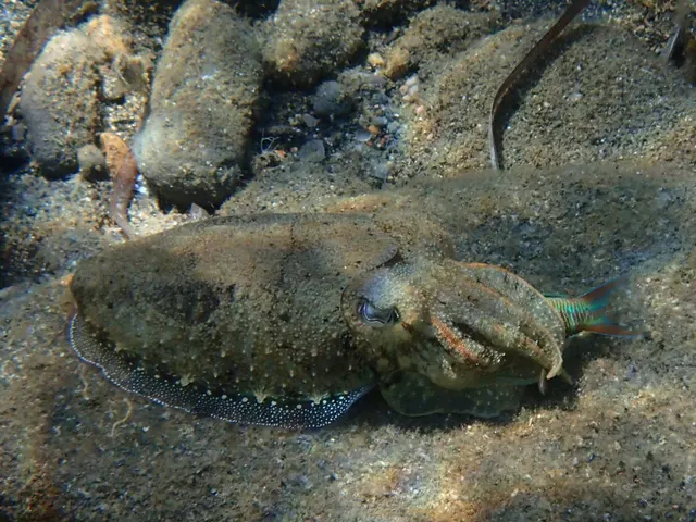 Common cuttlefishA bottom-oriented cephalopod with an internal buoyancy shell, the best-studied invertebrate mind in the sea, and a fishery that works quite differently from squid.
Katerina Kalogerini — CC BY, via iNaturalist
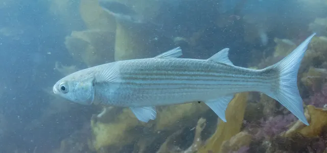 Flathead grey mulletThe most widely distributed mullet in the world, found on almost every warm and temperate coast, and a detritus feeder with a gizzard-like stomach.
Diego Delso, CC BY-SA 4.0, via Wikimedia Commons
 European sea bassA fast, predatory inshore fish that hunts in broken water and surf, and one of the most closely managed recreational species in European seas.
Julien Renoult — CC BY 4.0, via Wikimedia Commons
Places within this area
Publicly documented fishing geography. FishingHQ describes what the ground is; it does not say whether you may fish it, and every one of these sends that question to the body that holds the answer. Browse every place in this part of the world.
Who to ask before fishing any of these
FishingHQ does not know the current access position here. The Canary Islands are an autonomous community licensing their own recreational sea, boat and underwater fishing, separately from mainland Spain, and the archipelago carries marine reserves in which fishing and diving are restricted or prohibited on boundaries a visitor cannot see from the shore. Measures change. Check the current position with the Canarian government's fisheries administration before going.
Puerto Calero, Lanzarote
Harbour wall · Salt water
A purpose-built marina cut into the low volcanic coast between Puerto del Carmen and Playa Quemada, with a stone mole, a short pier outside the harbour mouth, and broken lava and boulder immediately outside the entrance.
On the sheltered southern coast, in the lee of the island from the prevailing north-easterly trade wind, which is why the sport fishing fleet is based along this stretch rather than on the north.
Particular to this ground: boat traffic and being seen, sun, dehydration and fatigue.
Severe hazards of Lanzarote apply here: cliffs and rock platforms.
Particular to this water: This is an owned and operated structure. Whether angling is allowed on it, when, from where and on what terms is the operator's decision, is frequently seasonal, and changes without notice.
The cliff coast between Puerto del Carmen and Puerto Calero
Rock mark · Salt water
A low cliff coast of broken lava between the two harbours, with a walked path along the top and, below it, reefy mixed ground in places and rocky outcrops with deep water immediately in front of them in others. Paths down to the water exist where divers have made them.
Sheltered from the trade wind by the island, and open to whatever southerly swell reaches the coast — which is enough to make the lower ledges wet in anything other than calm.
Particular to this ground: cliffs and rock platforms, drowning and immersion, sun, dehydration and fatigue.
Particular to this water: Underwater fishing is licensed and regulated separately from rod fishing throughout this jurisdiction, with its own age, equipment and distance requirements, and holding a rod licence is not permission to spearfish.
Punta Pechiguera, Lanzarote
Headland · Salt water
The south-western corner of Lanzarote: a low, flat, black lava point carrying two lighthouses, with broken volcanic ledge and boulder at the water's edge and the strait towards Fuerteventura opening to the south.
The corner of the island, so it takes both the Atlantic swell running down the west coast and the acceleration of the trade wind around the point. It is materially rougher than the resort coast a short distance east of it.
Particular to this ground: cliffs and rock platforms, drowning and immersion, sun, dehydration and fatigue.
Particular to this water: Underwater fishing is licensed and regulated separately from rod fishing throughout this jurisdiction, with its own age, equipment and distance requirements, and holding a rod licence is not permission to spearfish.
The Playa Dorada breakwater, Playa Blanca
Breakwater · Salt water
A rock breakwater sheltering a small sandy resort beach on Lanzarote's southern coast, with sand inside the arm, boulder armour along its face, and broken volcanic ground beyond the head.
On the sheltered south coast in the lee of the island, and further sheltered by the arm itself — which is the whole reason the beach behind it is sand rather than lava.
Particular to this ground: cliffs and rock platforms, sun, dehydration and fatigue.
Particular to this water: This is an owned and operated structure. Whether angling is allowed on it, when, from where and on what terms is the operator's decision, is frequently seasonal, and changes without notice.
Playa de Famara, Lanzarote
Surf beach · Salt water
A long open sand beach on Lanzarote's exposed north-west coast, running below the Risco de Famara cliffs, with clean sand along most of its length and rock at either end.
The most exposed accessible beach on the island. It takes the north-westerly Atlantic swell without any shelter at all, which is why it is the island's surfing beach and why the fishing on it is conditional on the sea rather than on the season.
Particular to this ground: drowning and immersion, sun, dehydration and fatigue.
Severe hazards of Lanzarote apply here: cliffs and rock platforms.
Los Hervideros, Lanzarote
Rock mark · Salt water
A stretch of black basaltic lava cliff on Lanzarote's exposed west coast, undercut into caves and blowholes by the swell, with deep water immediately below and no beach or landing anywhere along it.
Takes Atlantic swell directly on a coast with no shelf to slow it, which is why the sea explodes through the undercuts and gives the place its name.
Particular to this ground: cliffs and rock platforms, sun, dehydration and fatigue.
Puerto del Carmen harbour, Lanzarote
Harbour wall · Salt water
A small sheltered harbour on Lanzarote's south coast with a stone mole, sand in the bay beside it and a volcanic slope immediately outside that drops steeply into deep water within metres of the shore.
Sheltered from the prevailing north-easterly trade wind by the island itself.
Particular to this ground: boat traffic and being seen, sun, dehydration and fatigue.
Severe hazards of Lanzarote apply here: cliffs and rock platforms.
Particular to this water: This is an owned and operated structure. Whether angling is allowed on it, when, from where and on what terms is the operator's decision, is frequently seasonal, and changes without notice. Underwater fishing is licensed and regulated separately from rod fishing throughout this jurisdiction, with its own age, equipment and distance requirements, and holding a rod licence is not permission to spearfish.
Playa Quemada, Lanzarote
Cove · Salt water
A small dark shingle-and-sand cove on Lanzarote's quiet southern coast below the Femés ridge, with low broken rock at both ends and mixed ground running out from it.
Sheltered from the prevailing north-easterly by the island behind it, and among the calmest shore ground on Lanzarote.
Particular to this ground: cliffs and rock platforms, sun, dehydration and fatigue.
Particular to this water: A Canary recreational fishing licence is required, separately for shore, boat and underwater fishing. FishingHQ does not hold the current requirements — check with the Canary regional fisheries authority before fishing.
8 more places in this area
La Santa, Lanzarote
Rock platform · Salt water
Low black lava platform and reef on Lanzarote's exposed north-west coast, with the lagoon behind La Santa village and open Atlantic in front of it.
One of the most exposed pieces of shore in the archipelago. Canary sources name it as attractive ground and warn about the currents in the same breath, and both halves of that belong on the record.
Particular to this ground: cliffs and rock platforms, drowning and immersion, sun, dehydration and fatigue.
Particular to this water: A Canary recreational fishing licence is required, separately for shore, boat and underwater fishing. FishingHQ does not hold the current requirements — check with the Canary regional fisheries authority before fishing.
The Costa Teguise shore, Lanzarote
Rock platform · Salt water
Low cut lava between the small engineered beaches of the resort coast on Lanzarote's east side, with rock ledges, pools and sand pockets alternating along it. The structures a resident guide names as marks along it are the breakwaters that shelter Playa de las Cucharas and Playa del Jablillo, and the rocks at Playa Bastián.
Moderately exposed to the trade wind but without the swell that works the north and west coasts.
Particular to this ground: cliffs and rock platforms, sun, dehydration and fatigue.
Particular to this water: A Canary recreational fishing licence is required, separately for shore, boat and underwater fishing. FishingHQ does not hold the current requirements — check with the Canary regional fisheries authority before fishing.
Órzola
Harbour wall · Salt water
The small ferry and fishing harbour at the northern tip of Lanzarote, with a mole enclosing it, white sand coves either side and the channel to La Graciosa running past the entrance.
Open north; the mole is the shelter and the channel outside it is not sheltered at all.
Severe hazards of Lanzarote apply here: cliffs and rock platforms.
Arrieta and the Jameos coast
Rock platform · Salt water
Low black lava platform running south from the village along the island's north-east shore, cut into small caletas and pools, with the collapsed lava tubes of the Jameos behind it and mixed rock and sand outside.
Open north-east straight into the trade wind.
Particular to this ground: cliffs and rock platforms.
The Risco de Famara
Cliff coast · Salt water
A six-hundred-metre wall of cliff running along Lanzarote's north-west coast, with a boulder and platform shore at its foot reached by the few paths down it, and deep water immediately off the rock.
The most exposed coast on the island: open north-west to the full Atlantic with the cliff funnelling the wind down onto the shore.
Particular to this ground: cliffs and rock platforms, cliffs and rock platforms.
Papagayo and Playa Blanca
Cove · Salt water
The southern corner of Lanzarote: a run of small sheltered sand coves cut into low cliff at Papagayo, and the resort front and the lighthouse point at Pechiguera closing the western end of it.
In the island's lee and among the calmest water in the archipelago, which is why the sources name it as ground for anglers starting out.
Severe hazards of Lanzarote apply here: cliffs and rock platforms.
Particular to this water: The Papagayo coves lie inside a protected natural area with its own access, vehicle and use restrictions set by the island authority, independently of any fishing rule.
El Golfo and Janubio
Rock platform · Salt water
The west coast where the Timanfaya lava reached the sea: a black platform and boulder shore below the half-drowned crater at El Golfo, with the salt pans and the sand of Janubio to the south of it.
Open west to the Atlantic with no shelter, on a shore the swell works over constantly.
Particular to this ground: cliffs and rock platforms.
Arrecife and Playa Honda
Harbour wall · Salt water
The island capital's harbour front and the reefs it is named for, with the Charco de San Ginés lagoon behind, the commercial mole to the west and the long sand of Playa Honda running towards the airport.
Sheltered by the reefs the town is named after; the ground outside them is not.
Severe hazards of Lanzarote apply here: cliffs and rock platforms.
Safety
Further safety reading
- Rock platform and cliff safety — Recent lava is sharp, brittle and frequently undercut, and long-period Atlantic swell sweeps low platforms on days with no local wind at all.
- Sun, dehydration and fatigue — An arid low island with almost no shade and persistent wind masks heat load, and sun exposure and dehydration are consistently underestimated here.
Check the rules before you fish
Fishing laws, bylaws, access rules, seasons, bait restrictions and permitted methods vary by location and can change. Check the current rules from the relevant authority and the water you intend to fish before fishing.
Check with:
- Current national or regional law for where you are fishing
- Current local bylaws
- The relevant fisheries authority
- The landowner, club or fishery whose water it is
- Any restrictions specific to the species or the method you intend to use
Where to go next
What swims here
- Common cuttlefishThe shared shallow shelf with Fuerteventura supplies the structure and ground that cephalopods need and that the deep-sided western islands largely lack.
- European sea bassBass reach the Canaries at the southern edge of their range, which is part of what makes the archipelago's species list a mix of temperate Atlantic and subtropical.
- European squidOccupies the shallower ground of the eastern Canaries, where spawning structure exists in a way it does not off the steeper western islands.
- Flathead grey mulletOccupies harbours, sheltered bays and the island's limited brackish and shallow water, grazing the biofilm on hard surfaces.
- White seabreamA mainstream shore target over the island's volcanic rock and mixed ground, present year-round in Canarian waters.
Local knowledge
How this compares
- Canary IslandsThe archipelago page describes a volcanic, shelf-less, riverless system with deep water off the rocks. Lanzarote is the exception that makes the rule worth stating, because it shares a genuine shallow shelf with Fuerteventura.
- TenerifeThe two are close to opposites within one archipelago: Tenerife has the steepest drop-off and rewards a boat, Lanzarote has the only real shelf and rewards a car. That contrast is why both earn a record and the intermediate islands do not.
Sources and evidence
- FAO Species Identification Guides for Fishery Purposes and the FAO Species Catalogues — Food and Agriculture Organization of the United Nations (Scientific institute)Relied on for: Distribution, habitat and depth accounts for the species of the eastern central Atlantic in the FAO regional identification guides.States this directlyCitation checked — the work exists and is described correctly
- FishBase: a global information system on fishes — Froese, R. and D. Pauly, eds. — FishBase Consortium (Scientific institute)Relied on for: Distribution, habitat association and depth range recorded for the species.States this directlyPassage read and verified
Why the 11 connections on this page are here, and the sources
What swims here
Backed by research — 5 connections
Supported by peer-reviewed research or fisheries science. The sources are listed and can be checked.
Common cuttlefish
A distribution association between an animal and a kind of water, rather than a claim about any named mark.
- FishBase: a global information system on fishes — Froese, R. and D. Pauly, eds. — FishBase Consortium (Scientific institute)Relied on for: Distribution, habitat association and depth range recorded for the species, including its occurrence in the water body concerned.States this directlyPassage read and verified
- The IUCN Red List of Threatened Species — International Union for Conservation of Nature (Conservation authority)Relied on for: Assessment and range account for the species, including the systems and coasts it occupies.Background and mechanism onlyCitation checked — the work exists and is described correctly
European sea bass
A distributional claim taken from reference works on the fishes of the region rather than from angling report. It states presence and asserts nothing about a fishery.
- FishBase: a global information system on fishes — Froese, R. and D. Pauly, eds. — FishBase Consortium (Scientific institute)Relied on for: Distribution, habitat association, depth range and feeding behaviour recorded for the species concerned.States this directlyPassage read and verified
- The Fishes of the British Isles and North-West Europe — Macmillan, 1969 (Reference work)Relied on for: Distribution, habitat and biology of the fishes of the British Isles and north-west Europe.States this directlyCitation checked — the work exists and is described correctly
European squid
A distribution association between an animal and a kind of water, rather than a claim about any named mark.
- FishBase: a global information system on fishes — Froese, R. and D. Pauly, eds. — FishBase Consortium (Scientific institute)Relied on for: Distribution, habitat association and depth range recorded for the species, including its occurrence in the water body concerned.States this directlyPassage read and verified
- The IUCN Red List of Threatened Species — International Union for Conservation of Nature (Conservation authority)Relied on for: Assessment and range account for the species, including the systems and coasts it occupies.Background and mechanism onlyCitation checked — the work exists and is described correctly
Flathead grey mullet
A distribution association between an animal and a kind of water, rather than a claim about any named mark.
- FishBase: a global information system on fishes — Froese, R. and D. Pauly, eds. — FishBase Consortium (Scientific institute)Relied on for: Distribution, habitat association and depth range recorded for the species, including its occurrence in the water body concerned.States this directlyPassage read and verified
- The IUCN Red List of Threatened Species — International Union for Conservation of Nature (Conservation authority)Relied on for: Assessment and range account for the species, including the systems and coasts it occupies.Background and mechanism onlyCitation checked — the work exists and is described correctly
White seabream
A distribution association between an animal and a kind of water, rather than a claim about any named mark.
- FishBase: a global information system on fishes — Froese, R. and D. Pauly, eds. — FishBase Consortium (Scientific institute)Relied on for: Distribution, habitat association and depth range recorded for the species, including its occurrence in the water body concerned.States this directlyPassage read and verified
- The IUCN Red List of Threatened Species — International Union for Conservation of Nature (Conservation authority)Relied on for: Assessment and range account for the species, including the systems and coasts it occupies.Background and mechanism onlyCitation checked — the work exists and is described correctly
How people fish here
What experienced anglers do — 1 connection
Widely and independently recommended by experienced anglers and specialist sources. This is real angling knowledge, not proof: controlled evidence for it is limited, and FishingHQ records it as convention rather than as a demonstrated effect.
Sea fishing
A discipline that is characteristic of the place rather than merely possible there, joined so a reader can move between the place and the practice.
- General angling website restatements of established technique — Various (Credible secondary source)Relied on for: Widely restated practice associating this discipline with this place, recorded as practitioner consensus rather than as tested fact.Background and mechanism onlyCitation checked — the work exists and is described correctly
- Fishers' Craft and Lettered Art: Tracts on Fishing from the End of the Middle Ages — University of Toronto Press, 1997 (Scientific literature)Relied on for: That fishing traditions develop around the water and fish available to them, and the historical method of reading such traditions.States this directlyCitation checked — the work exists and is described correctly
Local knowledge
What experienced anglers do — 1 connection
Widely and independently recommended by experienced anglers and specialist sources. This is real angling knowledge, not proof: controlled evidence for it is limited, and FishingHQ records it as convention rather than as a demonstrated effect.
Bottom type, and what lives on it
A place joined to the mechanism that explains what is distinctive about fishing there, which is what makes a location page transferable rather than local colour.
- Sea Angler — Bauer Media (Specialist angling publication)Relied on for: Contemporary UK and European sea angling practice as reported by practitioners, including regional ground and species behaviour.States this directlyCitation checked — the work exists and is described correctly
- General angling website restatements of established technique — Various (Credible secondary source)Relied on for: Widely restated descriptions of regional angling practice, recorded as consensus rather than as scholarship.Background and mechanism onlyCitation checked — the work exists and is described correctly
How this compares
What experienced anglers do — 2 connections
Widely and independently recommended by experienced anglers and specialist sources. This is real angling knowledge, not proof: controlled evidence for it is limited, and FishingHQ records it as convention rather than as a demonstrated effect.
Canary Islands
Two places a reader would reasonably weigh against one another, joined where the comparison teaches something about both.
- General angling website restatements of established technique — Various (Credible secondary source)Relied on for: Widely restated practice associating this discipline with this place, recorded as practitioner consensus rather than as tested fact.Background and mechanism onlyCitation checked — the work exists and is described correctly
- Fishers' Craft and Lettered Art: Tracts on Fishing from the End of the Middle Ages — University of Toronto Press, 1997 (Scientific literature)Relied on for: That fishing traditions develop around the water and fish available to them, and the historical method of reading such traditions.States this directlyCitation checked — the work exists and is described correctly
Two places or records a reader will hold together, joined where the comparison teaches something neither states alone.
- Sea Angler — Bauer Media (Specialist angling publication)Relied on for: Contemporary UK and European sea angling practice as reported by practitioners, including regional ground and species behaviour.States this directlyCitation checked — the work exists and is described correctly
- General angling website restatements of established technique — Various (Credible secondary source)Relied on for: Widely restated descriptions of regional angling practice, recorded as consensus rather than as scholarship.Background and mechanism onlyCitation checked — the work exists and is described correctly
Tenerife
Two places a reader would reasonably weigh against one another, joined where the comparison teaches something about both.
- General angling website restatements of established technique — Various (Credible secondary source)Relied on for: Widely restated practice associating this discipline with this place, recorded as practitioner consensus rather than as tested fact.Background and mechanism onlyCitation checked — the work exists and is described correctly
- Fishers' Craft and Lettered Art: Tracts on Fishing from the End of the Middle Ages — University of Toronto Press, 1997 (Scientific literature)Relied on for: That fishing traditions develop around the water and fish available to them, and the historical method of reading such traditions.States this directlyCitation checked — the work exists and is described correctly
Safety reading
Official guidance — 2 connections
Stated by a fisheries authority, scientific institute or recognised angling body. Authoritative, but summarising rather than demonstrating.
Rock platform and cliff safety
A place is joined to the safety topic that explains a hazard genuinely characteristic of it, so the mechanism is reachable rather than restated as a weak warning.
- United States Lifesaving Association public education on rip currents and the surf zone — United States Lifesaving Association (Water-safety or diver-training authority)Relied on for: Surf zone hazards, wave behaviour, shore-break and the mechanisms by which people are swept from exposed shores.States this directlyCitation checked — the work exists and is described correctly
- RNLI water safety guidance: cold water shock and Float to Live — Royal National Lifeboat Institution (Water-safety or diver-training authority)Relied on for: Shore angling hazards including being swept in, shore-break and cold water shock.States this directlyPassage read and verified
Sun, dehydration and fatigue
A place is joined to the safety topic that explains a hazard genuinely characteristic of it, so the mechanism is reachable rather than restated as a weak warning.
- RNLI water safety guidance: cold water shock and Float to Live — Royal National Lifeboat Institution (Water-safety or diver-training authority)Relied on for: Cold water shock and the immersion response, shore angling hazards, small-craft guidance and the circumstances in which water users are most often killed.States this directlyPassage read and verified
- RoSPA water safety information and UK accidental drowning statistics — Royal Society for the Prevention of Accidents (Water-safety or diver-training authority)Relied on for: Accidental drowning statistics and the circumstances in which recreational water users are most often killed.Background and mechanism onlyPassage read and verified
How FishingHQ labels evidence is explained in the evidence policy.