Cape Verde
Fishing regions · Last reviewed 2026-08-19
Ten volcanic islands six hundred kilometres off West Africa, where oceanic water comes within casting range of a beach and the fishing changes from shore-caught jacks to blue-water game inside a mile.
Being listed here is not permission to fish. What that meansClose
Access, fishing rights, seasons, licences, local bylaws and permitted methods vary and can change. Check current access, permission, local regulations, closures and restrictions before you travel or fish. FishingHQ describes what the ground is and names who holds the answer; it does not hold the answer itself.
Find the authority for a jurisdiction · What FishingHQ does and does not cover
CAPE VERDE IS AN OCEANIC ARCHIPELAGO RATHER THAN A CONTINENTAL COAST, AND THAT IS THE WHOLE DIFFERENCE.
The islands are volcanic peaks rising from deep ocean, six hundred kilometres from the African mainland. There is almost no continental shelf. Depth falls away sharply from the shore on most coasts, which means the water a shore angler is casting into is oceanic rather than coastal — and the fish that come into it are oceanic fish that would be a boat trip away almost anywhere in Europe.
SO THE SHORE FISHING IS UNUSUALLY GOOD AND UNUSUALLY VARIED. Rock marks and harbour walls produce jacks, snappers, groupers, triggerfish, moray and a run of pelagic visitors — the fishing an angler would expect from a boat in the Canaries is available from a ledge here. The islands' beaches are long and often steeply shelving, and the surf fishing on them is genuinely productive rather than a consolation.
THE BLUE WATER IS THE HEADLINE AND IT IS CLOSE. Cape Verde is internationally known for large blue marlin, and the reason is geographic: the fish are on a migration route and the drop-off is close enough that a boat reaches marlin water within an hour of leaving harbour. Wahoo, tuna, sailfish and dorado are the rest of that fishery. It is a charter proposition and it is expensive, and this page is explicit that most visitors will not do it.
AND THE ISLANDS ARE NOT INTERCHANGEABLE. Sal and Boa Vista are flat, sandy, dry, windy and where most package tourism goes. São Vicente, Santo Antão and Santiago are mountainous, greener and have larger working fishing communities. Fogo is a volcano. The fishing, the ground and the access differ substantially between them, and 'Cape Verde' as a single answer is not much more use than 'Britain' would be.
WIND IS THE ORGANISING CONDITION. The north-east trades blow hard and consistently for much of the year, which is why the islands are a kitesurfing destination and why they are frequently unfishable from an exposed eastern shore. The lee side of an island is a different day from the windward side, and choosing which coast to fish is the first decision rather than a refinement.
THE INFORMATION PROBLEM IS REAL AND IS WHY THIS PAGE EXISTS. The working language is Portuguese and Cape Verdean Creole, the local fishing knowledge is oral and artisanal, and almost everything published in English is charter marketing for the marlin fishery. A visitor who wants to fish from the shore for an afternoon has very little to go on.
What fishing here is like
Ten volcanic islands and several islets in the eastern central Atlantic, roughly 600 km west of Senegal, rising steeply from deep ocean with almost no continental shelf. Arid to semi-arid, with no permanent rivers of consequence and effectively no freshwater fishing. The eastern islands — Sal, Boa Vista, Maio — are low, flat and sandy; the western and central ones — Santo Antão, São Vicente, Santiago, Fogo, Brava — are mountainous and steep-to. Water is warm year-round, clear, and oceanic within a very short distance of the shore. The north-east trade winds blow strongly and consistently for much of the year and dominate where and whether fishing is possible.
What dominates
Shore fishing from rock, ledge and harbour wall for jacks, snappers, groupers, triggerfish and moray, which is the most accessible and least documented fishing here. Surf and beach fishing on the long sandy shores of the eastern islands. Lure fishing and popping from rock marks for jacks and other pelagic visitors, which the deep close-in water makes unusually viable. Offshore charter fishing for blue marlin, wahoo, tuna, sailfish and dorado, for which the islands are internationally known and which is a substantial and expensive sector. Spearfishing and freediving are practised, with visibility and water temperature both favourable. Artisanal handline and small-boat fishing remains a working livelihood across the islands and is not a tourist activity.
The water available
Steep volcanic rock coasts and ledges with deep water immediately offshore. Long sandy beaches, particularly on Sal, Boa Vista and Maio, several of them steeply shelving into surf. Harbours and breakwaters, which are the most accessible and most productive shore marks on most islands. Small bays and sheltered coves on the lee sides. Reef and hard-bottom ground close inshore. A very short transition to oceanic depth on most coasts, with seamounts and drop-offs within easy reach of a boat. Effectively no estuaries, no lagoons and no fresh water.
How the rules are structured
Cape Verde is a single sovereign state and administers its own fisheries, which is simpler than most island destinations on FishingHQ. Recreational sea angling from the shore has historically been lightly regulated in practice, and that is a statement about practice rather than about what the rules are. Protected marine areas exist around several islands and around the turtle nesting beaches in particular, and they carry restrictions that differ from the general position. Spearfishing is subject to its own provisions, which as everywhere on FishingHQ differ from those governing rod fishing and should never be assumed from them. Several species are protected, and the marine turtle and shark provisions are the ones a visitor is most likely to encounter without expecting to. FishingHQ does not state what any current rule is; the national fisheries authority and the relevant protected-area administration hold the position, and a charter operator is a reasonable practical source for the offshore fishery specifically.
Who to ask
- The national fisheries administration of Cape Verde, which sets the recreational and commercial framework for the whole archipelago.
- Protected-area and natural-reserve administrations, which cover substantial parts of several islands' coasts and the turtle nesting beaches, and which frequently modify what the general position allows.
- Municipal and island-level authorities, which in practice administer harbour access and some local restrictions.
- Licensed charter operators, which are the practical source for the offshore fishery's own rules, permits and tagging conventions rather than an authority in their own right.
Words you will meet
- Morea
- Moray eel in Cape Verdean usage, and a very common shore capture over the rock ground. It is eaten locally and it is also the animal most likely to injure an angler here.
- Garoupa
- Grouper, across the Portuguese-speaking Atlantic. Several species are lumped under it and their conservation positions differ considerably, which makes it a name to be careful with.
- Serra
- Wahoo, in Cape Verdean and West African Portuguese usage — literally 'saw', for the teeth. A major offshore catch and a common name on a menu.
- Cavala
- Used for mackerel and for several jack and scad species depending on island and speaker, which is exactly the kind of shared vernacular that makes a market name a poor identification.
- Botica / pesca de fundo
- Bottom fishing, as distinct from trolling or surface work. The phrase a visitor will hear when asking what is being done off a harbour wall.
Conditions and hazards
The dominant hazard is the sea itself on a coast with deep water immediately offshore and no shelf to absorb swell. Atlantic groundswell arrives on exposed coasts with very little warning and rock ledges that are dry for an hour are not safe for that reason; the same feature that makes the shore fishing good — deep water at the rock — is what makes a wave dangerous there. The north-east trades are strong and persistent and turn an exposed coast unfishable and a small boat trip uncomfortable or unsafe. Sun and heat are constant and the islands are arid: shade is scarce on the eastern islands and dehydration is a genuine rather than a theoretical risk. Currents between islands and off headlands are strong. Moray are abundant on the rock ground and cause serious hand injuries to anglers who reach for them; several other species carry spines. Medical facilities vary substantially between islands and the smaller ones have limited capacity, which lengthens the consequence of any injury. Marine turtles nest on several beaches and disturbing them is both a conservation and a legal matter.
Why the shore fishing is better than it has any right to be
Most island destinations offer a shore angler the small resident fish of a shallow shelf and reserve everything interesting for a boat. Cape Verde does not, and the reason is bathymetric rather than biological.
THERE IS ALMOST NO SHELF. These are volcanic peaks standing in deep ocean. On many coasts the bottom falls to a hundred metres within a very short distance of the rock, and to far more not much further out. A cast from a ledge lands in water that on a continental coast would be several kilometres offshore.
SO OCEANIC FISH COME WITHIN RANGE. Jacks and other fast pelagic hunters follow bait right into the rock, and they do so routinely rather than exceptionally. That is why popping and spinning from rock marks works here and is close to pointless on a shelving European beach — the fish that would make it worthwhile are simply not there.
THE RESIDENT GROUND IS GOOD TOO, AND IT IS ROUGH. Volcanic rock, boulder and hard bottom hold groupers, snappers, triggerfish, wrasse and a great deal of moray. This is tackle-losing ground and it rewards the arrangements FishingHQ holds for exactly that: a rotten bottom or weak link above the lead, so a snag costs a weight rather than a whole trace.
THE HARBOUR WALLS ARE THE PRACTICAL ANSWER FOR MOST VISITORS. They are safe standing, they are reachable without a vehicle, they are lit at night, they have deep water beneath them, and they concentrate fish because of the boat activity and the discards. An hour on a harbour wall is the single most reliable way for a visitor to fish here, and it is the option no marketing material mentions.
AND THE BEACH FISHING IS REAL. The long sandy shores of Sal, Boa Vista and Maio produce in the surf, particularly at night and at either end of the day. The steep shelving profile means a bait does not need to go far.
WHAT THE DEEP WATER TAKES AWAY. There is very little shallow productive ground of the kind that makes a shelving coast easy to read. There are no estuaries to concentrate food, no lagoons, and effectively no fresh water. A reader who fishes British estuaries and beaches has to unlearn most of their location logic here, because the feature that holds fish is depth and structure rather than a food-carrying tide.
What experienced anglers do — why, and the sources (2)
Widely and independently recommended by experienced anglers and specialist sources. This is real angling knowledge, not proof: controlled evidence for it is limited, and FishingHQ records it as convention rather than as a demonstrated effect.
- FAO Species Identification Guides for Fishery Purposes and the FAO Species Catalogues — Food and Agriculture Organization of the United Nations (Scientific institute)Relied on for: Distribution, habitat association and identification of the fishes of the eastern central Atlantic and the Mediterranean, from the regional identification guides prepared for fishery purposes.States this directlyCitation checked — the work exists and is described correctly
- FishBase: a global information system on fishes — Froese, R. and D. Pauly, eds. — FishBase Consortium (Scientific institute)Relied on for: Recorded environment, depth range, distribution and biology of the species named.States this directlyPassage read and verified
The marlin fishery, honestly, and what a visitor who is not doing it should know
Cape Verde's international reputation rests almost entirely on one fishery, and it is worth separating what is true about it from what it implies for an ordinary visitor.
THE BLUE MARLIN FISHING IS GENUINELY EXCEPTIONAL AND IT IS SEASONAL. The islands sit on a migration route and the drop-off is close inshore, so boats reach marlin ground quickly. The concentration of large fish in the season is what draws international crews, and the season is a matter of months rather than the whole year — which is the first thing a visitor should establish, because outside it the offshore fishing is a different and less remarkable proposition.
IT IS A CHARTER ACTIVITY AND IT IS EXPENSIVE. A day on a properly equipped boat with a competent crew is a significant cost, and there is no shore-based or cheap version of it. This page does not rank operators and FishingHQ does not: what it will say is that the questions worth asking before booking are about the boat's tackle, the crew's handling and release practice, and what happens if the weather closes the trip.
RELEASE PRACTICE IS THE PART WORTH CARING ABOUT. Billfish are released as a matter of course in this fishery and the manner of it decides whether the fish survives. A crew that keeps the fish in the water, minimises fight time, and uses tackle heavy enough to bring it in quickly is doing something materially different from one that plays a fish to exhaustion on light gear for a photograph. That is a reasonable thing to ask about in advance and a reasonable basis on which to choose.
AND WAHOO AND TUNA ARE THE FISHERY MOST VISITORS ACTUALLY WANT. They are available over a longer season, on shorter and cheaper trips, on tackle that is less specialised, and they are excellent to eat. A half-day trolling trip is within reach of an ordinary holiday budget in a way a marlin day is not.
WHAT NONE OF THIS MEANS FOR THE SHORE ANGLER. The marlin fishery is offshore, seasonal and separate, and its existence tells a visitor nothing about whether the harbour wall will produce. The two are different fisheries that happen to share an island, and the reason this page spends most of its length on the shore is that the shore is the part nobody writes about.
What experienced anglers do — why, and the sources (3)
Widely and independently recommended by experienced anglers and specialist sources. This is real angling knowledge, not proof: controlled evidence for it is limited, and FishingHQ records it as convention rather than as a demonstrated effect.
- FAO Species Identification Guides for Fishery Purposes and the FAO Species Catalogues — Food and Agriculture Organization of the United Nations (Scientific institute)Relied on for: Distribution, habitat association and identification of the fishes of the eastern central Atlantic and the Mediterranean, from the regional identification guides prepared for fishery purposes.States this directlyCitation checked — the work exists and is described correctly
- Good Fish Guide — Marine Conservation Society (Conservation authority)Relied on for: Synthesis of fishing gear impacts, stock status and the pressures on coastal and pelagic fisheries.Background and mechanism onlyCitation checked — the work exists and is described correctly
- The IUCN Red List of Threatened Species — International Union for Conservation of Nature (Conservation authority)Relied on for: Conservation assessments of the species named and the basis for the extinction-risk statements made.States this directlyCitation checked — the work exists and is described correctly
Ten islands, and choosing between them is the first fishing decision
Package marketing treats Cape Verde as one destination. For fishing it is not, and a visitor who books the wrong island for what they want to do has made the decision that matters before they arrive.
SAL AND BOA VISTA ARE WHERE MOST VISITORS GO and they are the flattest, driest and windiest. Long sandy beaches, big resort development, good surf and beach fishing, harbours with accessible walls, and comparatively little rock coast within easy reach. They are the easiest islands to visit and the least varied to fish.
SÃO VICENTE AND SANTIAGO HAVE THE LARGEST WORKING PORTS. That means real harbours, real fishing communities, an artisanal fleet, and considerably better access to boats and to local knowledge — and it means the fishing culture is a working one rather than a recreational one, which changes how a visitor should approach asking.
SANTO ANTÃO AND FOGO ARE MOUNTAINOUS AND STEEP-TO. Rock coasts with very deep water immediately offshore, difficult and sometimes dangerous access, and correspondingly little fishing pressure. These are the islands where the physical conditions that make rock fishing productive are most pronounced, and where the consequences of misjudging a swell are correspondingly greater.
MAIO AND BRAVA ARE QUIET. Few visitors, limited infrastructure, and correspondingly limited help if something goes wrong.
THE WIND DECIDES THE DAY MORE THAN THE ISLAND DOES. The north-east trades blow across the whole archipelago, so on any given island the windward coast may be unfishable while the lee coast is calm. That is the reason a small island can offer a usable day when the forecast looks impossible, and it is the single most useful piece of local knowledge a visitor can acquire.
AND INTER-ISLAND TRAVEL IS NOT TRIVIAL. Flights and ferries between islands are limited, weather-dependent and not always frequent. Planning to fish several islands in a week is optimistic, and a fishing trip built around one island and its lee coast is more likely to produce than one built around moving.
What experienced anglers do — why, and the sources (2)
Widely and independently recommended by experienced anglers and specialist sources. This is real angling knowledge, not proof: controlled evidence for it is limited, and FishingHQ records it as convention rather than as a demonstrated effect.
- FAO Species Identification Guides for Fishery Purposes and the FAO Species Catalogues — Food and Agriculture Organization of the United Nations (Scientific institute)Relied on for: Distribution, habitat association and identification of the fishes of the eastern central Atlantic and the Mediterranean, from the regional identification guides prepared for fishery purposes.States this directlyCitation checked — the work exists and is described correctly
- The European Environment Agency's assessments of Europe's waters, seas and coasts — European Environment Agency, Copenhagen (Conservation authority)Relied on for: State-of-the-environment assessment of Europe's seas, including the Mediterranean, and the coverage and designation of marine protected sites.States this directlyCitation checked — the work exists and is described correctly
Some of what lives here
Fish recorded here that FishingHQ holds a reviewed photograph of. It is not a complete list of what Cape Verde holds, and it is not a prediction that you will catch any of them — it is a way in to the ones we can show you.
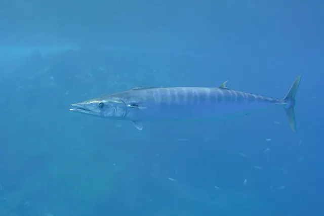 WahooAn extremely fast blue-water mackerel with razor teeth and a long slender body, taken by high-speed trolling and almost always fished on wire.
Bommerer — CC BY 4.0, via Wikimedia Commons
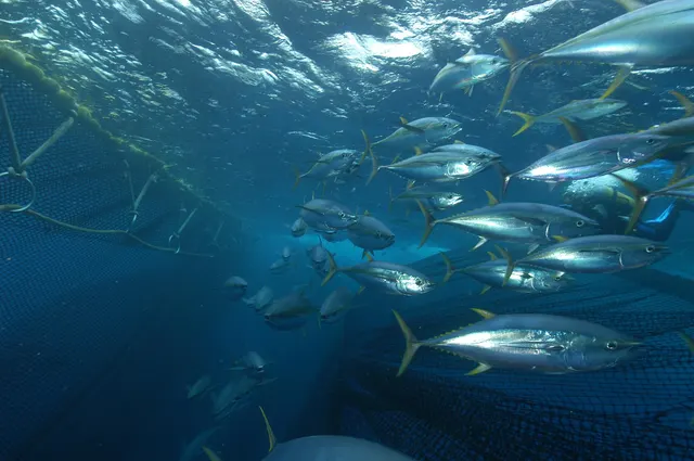 Yellowfin tunaA warm-blooded, high-speed oceanic predator that schools with dolphins and under floating debris, and one of the most commercially important fish in the world.
Marc Taquet — CC BY 4.0, via Wikimedia Commons
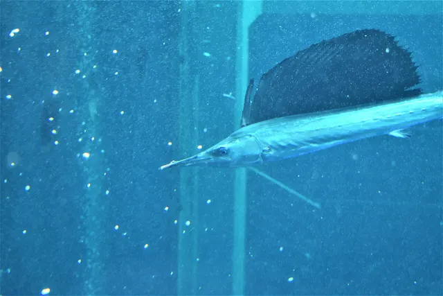 SailfishThe billfish with a sail — a dorsal fin taller than the fish is deep, raised when hunting, and probably the fastest accelerator in the ocean.
出羽雀台 — CC BY-SA 4.0, via Wikimedia Commons
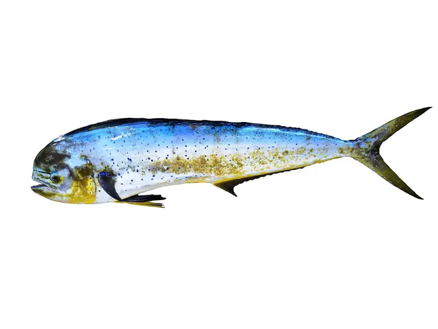 Mahi-mahiThe fastest-growing large fish an angler is likely to meet — brilliantly coloured, mature within months, and gathered around anything floating in the open ocean.
Hugues Evano (IFREMER, Délégation océan Indien (DOI), Département Ressources Biologiques et Environnement (RBE), F-97420 Le Port, France) — CC BY 4.0, via Wikimedia Commons
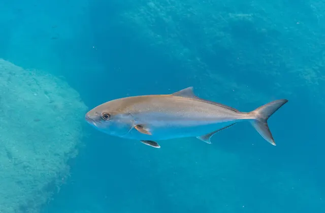 Greater amberjackThe largest amberjack — a circumglobal reef and wreck predator that fights downward with more raw power per kilogram than almost anything, and carries a genuine ciguatera caveat.
Diego Delso — CC BY-SA 4.0, via Wikimedia Commons
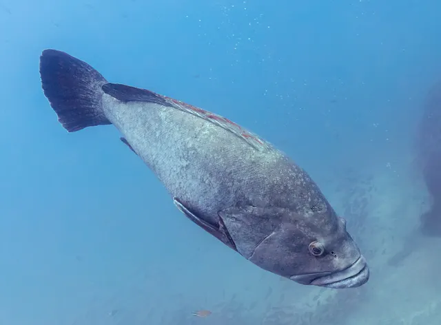 Dusky grouperThe Mediterranean's iconic reef predator: territorial, slow to mature, sex-changing, and the species whose decline made the case for marine protected areas there.
Diego Delso — CC BY-SA 4.0, via Wikimedia Commons
Safety
Further safety reading
- Rock platform and cliff safety — The feature that makes the shore fishing good is the feature that makes it dangerous. Deep water immediately off the rock means Atlantic groundswell arrives at the ledge without a shelf to break on, so a platform that has been dry for an hour is not evidence of anything. Access to rock marks on the mountainous islands is steep and difficult, and medical capacity on the smaller islands is limited enough to lengthen the consequence of any injury.
- Sun, dehydration and fatigue — Arid islands with almost no shade on the eastern ones, constant strong sun, and a persistent wind that makes heat load easy to underestimate because it feels cool. Water has to be carried; there is nowhere to get it on most marks.
Check the rules before you fish
Fishing laws, bylaws, access rules, seasons, bait restrictions and permitted methods vary by location and can change. Check the current rules from the relevant authority and the water you intend to fish before fishing.
Check with:
- Current national or regional law for where you are fishing
- Current local bylaws
- The relevant fisheries authority
- The landowner, club or fishery whose water it is
- Any restrictions specific to the species or the method you intend to use
Where to go next
What swims here
- Common octopusPresent on the rock and hard bottom and taken both by shore anglers and by the artisanal fishery. Part of the non-finfish layer that most travel writing about a destination omits entirely.
- Dusky grouperResident on the volcanic hard bottom close inshore. A long-lived, slow-growing, heavily fished species whose conservation position is considerably worse than its abundance on a menu suggests, and one of the reasons the vernacular name garoupa is a poor identification.
- Greater amberjackThe fish that makes rock fishing here worth the effort. Amberjack hunt right into the rock because there is no shelf keeping them offshore, which is why popping and spinning from a ledge is viable here and close to pointless on a shelving European coast.
- Mahi-mahiFound around floating debris and weed lines offshore, and one of the more reliable warm-season captures on a trolling trip when the larger fish do not appear.
- Mediterranean morayAbundant on the rock ground, commonly taken from the shore, eaten locally, and the animal most likely to injure a visiting angler here. An angler who reaches for one rather than cutting the line is making the mistake FishingHQ's handling records exist to prevent.
- SailfishPresent in the offshore fishery alongside the marlin the islands are known for, and released as a matter of course. The release practice a crew uses is the thing worth asking about before booking.
- WahooThe offshore fish most visitors actually want, and the honest alternative to the marlin fishery: a longer season, shorter and cheaper trips, less specialised tackle, and excellent eating. Known locally as serra, for the teeth.
- Yellowfin tunaPart of the same blue-water fishery and available on the same trolling trips. The islands sit where oceanic water comes close to land, which is why a half-day trip reaches tuna ground at all.
How people fish here
How this compares
- Canary IslandsThe comparison a traveller will make and it holds better than most. Both are Atlantic volcanic archipelagos with deep water close inshore and a shore fishery of jacks, groupers and moray over rough volcanic ground. Cape Verde is hotter, more tropical, considerably windier, far less documented in English, and has a blue-water fishery close in that the Canaries do not match. The Canaries have infrastructure, information and easier access. The fishing logic transfers; the practical planning does not.
- CyprusBoth are warm islands with famously clear water and they fish nothing like each other, for a reason that is physical rather than incidental. Cape Verde has oceanic water against the rock and no shelf, so ocean fish come within casting range and the tackle scales up. Cyprus sits in a nearly enclosed, nutrient-poor basin where the clarity is evidence of how little is in the water, and the tackle scales down to hooks and lines a British sea angler would think were for coarse fishing. A traveller who has fished one will carry exactly the wrong assumptions to the other.
- The West African coastSix hundred kilometres of ocean separate them and it changes the fauna less than it changes the fishing. The mainland coast has a productive continental shelf, river input and turbid nutrient-rich water; the islands have none of that and have oceanic water at the rock instead. Species overlap substantially and the way they are caught does not.
Environment and conservation
Sources and evidence
- FAO Species Identification Guides for Fishery Purposes and the FAO Species Catalogues — Food and Agriculture Organization of the United Nations (Scientific institute)Relied on for: Distribution, habitat association and identification of the fishes of the eastern central Atlantic and the Mediterranean, from the regional identification guides prepared for fishery purposes.States this directlyCitation checked — the work exists and is described correctly
- FishBase: a global information system on fishes — Froese, R. and D. Pauly, eds. — FishBase Consortium (Scientific institute)Relied on for: Recorded environment, depth range, distribution and biology of the species named.States this directlyPassage read and verified
- The European Environment Agency's assessments of Europe's waters, seas and coasts — European Environment Agency, Copenhagen (Conservation authority)Relied on for: State-of-the-environment assessment of Europe's seas, including the Mediterranean, and the coverage and designation of marine protected sites.States this directlyCitation checked — the work exists and is described correctly
- Good Fish Guide — Marine Conservation Society (Conservation authority)Relied on for: Synthesis of fishing gear impacts, stock status and the pressures on coastal and pelagic fisheries.Background and mechanism onlyCitation checked — the work exists and is described correctly
- The IUCN Red List of Threatened Species — International Union for Conservation of Nature (Conservation authority)Relied on for: Conservation assessments of the species named and the basis for the extinction-risk statements made.States this directlyCitation checked — the work exists and is described correctly
Why the 15 connections on this page are here, and the sources
What swims here
Backed by research — 8 connections
Supported by peer-reviewed research or fisheries science. The sources are listed and can be checked.
Common octopus
A distribution edge resting on published regional identification and distribution references, written where the species is genuinely characteristic of the destination's fishing rather than merely recorded from its waters.
- FAO Species Identification Guides for Fishery Purposes and the FAO Species Catalogues — Food and Agriculture Organization of the United Nations (Scientific institute)Relied on for: Distribution, habitat association and biology of the fishes of the eastern central Atlantic and the Mediterranean, from the regional identification guides prepared for fishery purposes.States this directlyCitation checked — the work exists and is described correctly
- FishBase: a global information system on fishes — Froese, R. and D. Pauly, eds. — FishBase Consortium (Scientific institute)Relied on for: Recorded environment, depth range, distribution and biology of the species named.States this directlyPassage read and verified
Dusky grouper
A distribution edge resting on published regional identification and distribution references, written where the species is genuinely characteristic of the destination's fishing rather than merely recorded from its waters.
- FAO Species Identification Guides for Fishery Purposes and the FAO Species Catalogues — Food and Agriculture Organization of the United Nations (Scientific institute)Relied on for: Distribution, habitat association and biology of the fishes of the eastern central Atlantic and the Mediterranean, from the regional identification guides prepared for fishery purposes.States this directlyCitation checked — the work exists and is described correctly
- FishBase: a global information system on fishes — Froese, R. and D. Pauly, eds. — FishBase Consortium (Scientific institute)Relied on for: Recorded environment, depth range, distribution and biology of the species named.States this directlyPassage read and verified
Greater amberjack
A distribution edge resting on published regional identification and distribution references, written where the species is genuinely characteristic of the destination's fishing rather than merely recorded from its waters.
- FAO Species Identification Guides for Fishery Purposes and the FAO Species Catalogues — Food and Agriculture Organization of the United Nations (Scientific institute)Relied on for: Distribution, habitat association and biology of the fishes of the eastern central Atlantic and the Mediterranean, from the regional identification guides prepared for fishery purposes.States this directlyCitation checked — the work exists and is described correctly
- FishBase: a global information system on fishes — Froese, R. and D. Pauly, eds. — FishBase Consortium (Scientific institute)Relied on for: Recorded environment, depth range, distribution and biology of the species named.States this directlyPassage read and verified
Mahi-mahi
A distribution edge resting on published regional identification and distribution references, written where the species is genuinely characteristic of the destination's fishing rather than merely recorded from its waters.
- FAO Species Identification Guides for Fishery Purposes and the FAO Species Catalogues — Food and Agriculture Organization of the United Nations (Scientific institute)Relied on for: Distribution, habitat association and biology of the fishes of the eastern central Atlantic and the Mediterranean, from the regional identification guides prepared for fishery purposes.States this directlyCitation checked — the work exists and is described correctly
- FishBase: a global information system on fishes — Froese, R. and D. Pauly, eds. — FishBase Consortium (Scientific institute)Relied on for: Recorded environment, depth range, distribution and biology of the species named.States this directlyPassage read and verified
Mediterranean moray
A distribution edge resting on published regional identification and distribution references, written where the species is genuinely characteristic of the destination's fishing rather than merely recorded from its waters.
- FAO Species Identification Guides for Fishery Purposes and the FAO Species Catalogues — Food and Agriculture Organization of the United Nations (Scientific institute)Relied on for: Distribution, habitat association and biology of the fishes of the eastern central Atlantic and the Mediterranean, from the regional identification guides prepared for fishery purposes.States this directlyCitation checked — the work exists and is described correctly
- FishBase: a global information system on fishes — Froese, R. and D. Pauly, eds. — FishBase Consortium (Scientific institute)Relied on for: Recorded environment, depth range, distribution and biology of the species named.States this directlyPassage read and verified
Sailfish
A distribution edge resting on published regional identification and distribution references, written where the species is genuinely characteristic of the destination's fishing rather than merely recorded from its waters.
- FAO Species Identification Guides for Fishery Purposes and the FAO Species Catalogues — Food and Agriculture Organization of the United Nations (Scientific institute)Relied on for: Distribution, habitat association and biology of the fishes of the eastern central Atlantic and the Mediterranean, from the regional identification guides prepared for fishery purposes.States this directlyCitation checked — the work exists and is described correctly
- FishBase: a global information system on fishes — Froese, R. and D. Pauly, eds. — FishBase Consortium (Scientific institute)Relied on for: Recorded environment, depth range, distribution and biology of the species named.States this directlyPassage read and verified
Wahoo
A distribution edge resting on published regional identification and distribution references, written where the species is genuinely characteristic of the destination's fishing rather than merely recorded from its waters.
- FAO Species Identification Guides for Fishery Purposes and the FAO Species Catalogues — Food and Agriculture Organization of the United Nations (Scientific institute)Relied on for: Distribution, habitat association and biology of the fishes of the eastern central Atlantic and the Mediterranean, from the regional identification guides prepared for fishery purposes.States this directlyCitation checked — the work exists and is described correctly
- FishBase: a global information system on fishes — Froese, R. and D. Pauly, eds. — FishBase Consortium (Scientific institute)Relied on for: Recorded environment, depth range, distribution and biology of the species named.States this directlyPassage read and verified
Yellowfin tuna
A distribution edge resting on published regional identification and distribution references, written where the species is genuinely characteristic of the destination's fishing rather than merely recorded from its waters.
- FAO Species Identification Guides for Fishery Purposes and the FAO Species Catalogues — Food and Agriculture Organization of the United Nations (Scientific institute)Relied on for: Distribution, habitat association and biology of the fishes of the eastern central Atlantic and the Mediterranean, from the regional identification guides prepared for fishery purposes.States this directlyCitation checked — the work exists and is described correctly
- FishBase: a global information system on fishes — Froese, R. and D. Pauly, eds. — FishBase Consortium (Scientific institute)Relied on for: Recorded environment, depth range, distribution and biology of the species named.States this directlyPassage read and verified
How people fish here
What experienced anglers do — 1 connection
Widely and independently recommended by experienced anglers and specialist sources. This is real angling knowledge, not proof: controlled evidence for it is limited, and FishingHQ records it as convention rather than as a demonstrated effect.
Sea fishing
The discipline edge, written with the qualification that matters here: the absence of a freshwater half is a structural fact about arid oceanic islands rather than a gap in the record.
- The European Environment Agency's assessments of Europe's waters, seas and coasts — European Environment Agency, Copenhagen (Conservation authority)Relied on for: State-of-the-environment assessment of Europe's seas including the Mediterranean, nutrient status, and the coverage of marine protected sites.States this directlyCitation checked — the work exists and is described correctly
- EMODnet — the European Marine Observation and Data Network — The European Commission, assembled from the national hydrographic offices, geological surveys and marine institutes of the member states (Scientific institute)Relied on for: Bathymetry, salinity and physical oceanography of European and adjacent sea basins.States this directlyCitation checked — the work exists and is described correctly
How this compares
What experienced anglers do — 3 connections
Widely and independently recommended by experienced anglers and specialist sources. This is real angling knowledge, not proof: controlled evidence for it is limited, and FishingHQ records it as convention rather than as a demonstrated effect.
Canary Islands
A comparison written where a traveller will reach one record having read the other and would otherwise carry an assumption across that does not hold.
- FAO Species Identification Guides for Fishery Purposes and the FAO Species Catalogues — Food and Agriculture Organization of the United Nations (Scientific institute)Relied on for: Distribution, habitat association and biology of the fishes of the eastern central Atlantic and the Mediterranean, from the regional identification guides prepared for fishery purposes.States this directlyCitation checked — the work exists and is described correctly
- FishBase: a global information system on fishes — Froese, R. and D. Pauly, eds. — FishBase Consortium (Scientific institute)Relied on for: Recorded environment, depth range, distribution and biology of the species named.States this directlyPassage read and verified
Cyprus
A comparison written where a traveller will reach one record having read the other and would otherwise carry an assumption across that does not hold.
- The European Environment Agency's assessments of Europe's waters, seas and coasts — European Environment Agency, Copenhagen (Conservation authority)Relied on for: State-of-the-environment assessment of Europe's seas including the Mediterranean, nutrient status, and the coverage of marine protected sites.States this directlyCitation checked — the work exists and is described correctly
- EMODnet — the European Marine Observation and Data Network — The European Commission, assembled from the national hydrographic offices, geological surveys and marine institutes of the member states (Scientific institute)Relied on for: Bathymetry, salinity and physical oceanography of European and adjacent sea basins.States this directlyCitation checked — the work exists and is described correctly
The West African coast
A comparison written where a traveller will reach one record having read the other and would otherwise carry an assumption across that does not hold.
- FAO Species Identification Guides for Fishery Purposes and the FAO Species Catalogues — Food and Agriculture Organization of the United Nations (Scientific institute)Relied on for: Distribution, habitat association and biology of the fishes of the eastern central Atlantic and the Mediterranean, from the regional identification guides prepared for fishery purposes.States this directlyCitation checked — the work exists and is described correctly
- FishBase: a global information system on fishes — Froese, R. and D. Pauly, eds. — FishBase Consortium (Scientific institute)Relied on for: Recorded environment, depth range, distribution and biology of the species named.States this directlyPassage read and verified
Safety reading
Official guidance — 2 connections
Stated by a fisheries authority, scientific institute or recognised angling body. Authoritative, but summarising rather than demonstrating.
Rock platform and cliff safety
A destination joined to the hazard that is genuinely distinctive of it, rather than to the general hazards of being near water. Written where a visitor's home-coast habits are the specific thing that fails here.
- RNLI water safety guidance: cold water shock and Float to Live — Royal National Lifeboat Institution (Water-safety or diver-training authority)Relied on for: Water safety guidance including sudden immersion, swell on rock platforms and the behaviour that reduces the risk.Background and mechanism onlyPassage read and verified
- Rock fishing safety and the declared lifejacket areas of New South Wales — NSW Department of Primary Industries and Surf Life Saving NSW (Water-safety or diver-training authority)Relied on for: Rock fishing safety guidance including swell, wave sets on ledges and the equipment and behaviour that reduce drowning risk.States this directlyCitation checked — the work exists and is described correctly
Sun, dehydration and fatigue
A destination joined to the hazard that is genuinely distinctive of it, rather than to the general hazards of being near water. Written where a visitor's home-coast habits are the specific thing that fails here.
- RNLI water safety guidance: cold water shock and Float to Live — Royal National Lifeboat Institution (Water-safety or diver-training authority)Relied on for: Water safety guidance including sudden immersion, swell on rock platforms and the behaviour that reduces the risk.Background and mechanism onlyPassage read and verified
- Rock fishing safety and the declared lifejacket areas of New South Wales — NSW Department of Primary Industries and Surf Life Saving NSW (Water-safety or diver-training authority)Relied on for: Rock fishing safety guidance including swell, wave sets on ledges and the equipment and behaviour that reduce drowning risk.States this directlyCitation checked — the work exists and is described correctly
Environment and conservation
Official guidance — 1 connection
Stated by a fisheries authority, scientific institute or recognised angling body. Authoritative, but summarising rather than demonstrating.
Marine protected areas and spearfishing
Written because the overlap between protected and productive water is the practical constraint here, and because the turtle provisions are the ones a visitor is most likely to breach without intending to.
- The European Environment Agency's assessments of Europe's waters, seas and coasts — European Environment Agency, Copenhagen (Conservation authority)Relied on for: State-of-the-environment assessment of Europe's seas including the Mediterranean, nutrient status, and the coverage of marine protected sites.States this directlyCitation checked — the work exists and is described correctly
- EMODnet — the European Marine Observation and Data Network — The European Commission, assembled from the national hydrographic offices, geological surveys and marine institutes of the member states (Scientific institute)Relied on for: Bathymetry, salinity and physical oceanography of European and adjacent sea basins.States this directlyCitation checked — the work exists and is described correctly
How FishingHQ labels evidence is explained in the evidence policy.