The Isles of Scilly
Fishing regions · Last reviewed 2026-08-16
A granite archipelago forty kilometres off Land's End with the clearest inshore water in England, almost no fresh water, and a species list that runs warmer than anywhere else in these islands.
Safety: cliffs and rock platforms — can cause serious injury or death. 3 more points apply here.
Being listed here is not permission to fish. What that meansClose
Access, fishing rights, seasons, licences, local bylaws and permitted methods vary and can change. Check current access, permission, local regulations, closures and restrictions before you travel or fish. FishingHQ describes what the ground is and names who holds the answer; it does not hold the answer itself.
Find the authority for a jurisdiction · What FishingHQ does and does not cover
The Isles of Scilly are an archipelago-tier record because the islands share one physical system — a single granite platform, mostly shallow, sitting in oceanic water well clear of the mainland — and describing them individually would repeat that system five times.
THE GRANITE IS THE FOUNDATION AND IT IS ONE ROCK. The whole archipelago is the exposed top of a single granite mass, the westernmost of the batholiths that also make Dartmoor, Bodmin and West Penwith. That gives clean, hard, rounded rock, boulder shores, sand derived from weathered granite, and a shallow platform between the islands — much of the archipelago's interior is only a few metres deep, and at very low tides it is possible to walk between some islands.
THE WATER IS THE CLEAREST IN ENGLAND. Oceanic water, no significant river input, granite-derived sand rather than mud, and no continental shelf sediment nearby. Visibility here is regularly measured in tens of metres, which is why the archipelago supports serious diving and why sight fishing is a genuine proposition in a way it is not elsewhere in England.
THERE IS ALMOST NO FRESH WATER, and this is not a footnote. The islands are small and low with tiny catchments, so there are no rivers of any consequence, no salmonid runs, and no freshwater fishery at all. That absence is the most complete of any inhabited place in these islands and it shapes both the ecology and the culture.
THE SPECIES LIST RUNS WARMER. Sitting in the path of Atlantic water well south and west of the mainland, Scilly holds species that are scarce or absent elsewhere in England and sees warm-water strays with a regularity nowhere else matches. Red mullet, triggerfish, John Dory and a long list of southern occasionals are ordinary here.
AND THE WESTERN ROCKS ARE THE OTHER HALF OF THE PLACE. Beyond the inhabited islands lies a scatter of reefs, ledges and drying rocks running out into the Atlantic, with a wreck record among the worst in British waters. That is the ground the boat fishing works and it is also why this archipelago has the safety profile it does.
WHAT AN ANGLER FINDS is deep clean water close to shore, exceptional visibility, a mixed rock and sand fishery with a southern accent, a strong small-boat tradition, and almost no shelter when the Atlantic is running.
What fishing here is like
A low granite archipelago in oceanic water some forty kilometres west of the Cornish mainland, consisting of a few inhabited islands and a great many uninhabited islets and drying rocks on a single shallow granite platform. Ground is clean granite boulder, ledge and reef with granite-derived white sand between; there is essentially no mud and no significant river input. Water clarity is exceptional by British standards and the sea is Atlantic and comparatively mild. Tidal streams run strongly between the islands and around the outer reefs, and the archipelago is fully exposed to Atlantic swell with no shelter to the west.
What you can target here
One entry per fish, grouped by how you would be fishing — because the answer is a different one from the rocks and from a boat. Each entry says how strongly the sources support it and how much evidence sits behind it. These are documented catches, not a forecast, and none of it is a statement that you may fish any particular ground.
From the shore · 4
 Ballan wrasseCharacteristic of this water4 placesPeninnis Head, Old Town Bay, The Daymark, St Martin's, St Mary's Harbour and quayOver bay, harbour wall, headland
 PollackRegular local target4 placesPeninnis Head, Old Town Bay, St Mary's Harbour and quay, The Daymark, St Martin'sOver bay, harbour wall, headland
 Atlantic mackerelRegular local target2 placesPeninnis Head, St Mary's Harbour and quayOver harbour wall, headland
 Thick-lipped grey mulletRecorded here1 placePeninnis HeadOver headland
What these strengths mean
- Characteristic of this water
- This water is strongly identified with this species by the sources that cover it.
- Regular local target
- Fishing sources describe this as a normal local target here, not merely as caught.
- Recorded here
- At least one credible public account of this species being caught here. That is all it means.
- How breadth is counted
- A fish documented at six marks is shown as six marks: breadth never raises the strength on its own. A fishery account describes the fishing; a recorded catch reports one specific catch. How evidence is weighed.
How people fish here
5 methods are recorded on the places documented here, counted from the records themselves rather than from what is practised in the country. Each opens a full guide to the technique.
Light rock fishing
Recorded at 4 places here, over headland, bay, harbour wall.
Ultralight lure fishing from the shore with tackle rated in single grams — a discipline that catches the fish everybody else steps over, and one FishingHQ held every component of and had never named.
Documented on the same ground: Ballan wrasse, Atlantic mackerel, Pollack, Thick-lipped grey mullet.
Spinning
Recorded at 3 places here, over headland, bay.
Casting an artificial lure and retrieving it so that it moves like something alive — the most direct form of lure fishing.
Documented on the same ground: Ballan wrasse, Atlantic mackerel, Pollack, Thick-lipped grey mullet.
Feathering and multi-lure traces
Recorded at 1 place here, over harbour wall.
A string of small lures on droppers, worked in the water column — how most people in Britain and Ireland catch their first sea fish, and the method most likely to catch far more than anybody intended.
Documented on the same ground: Atlantic mackerel, Pollack, Ballan wrasse.
Float fishing
Recorded at 1 place here, over harbour wall.
Suspending a bait at a controlled depth beneath a buoyant indicator — the most visual, most controllable and most widely applicable method in angling.
Documented on the same ground: Atlantic mackerel, Pollack, Ballan wrasse.
Ledgering
Recorded at 1 place here, over headland.
Fishing a bait on the bottom held by a weight, with no float — the simplest way to fish at distance, in depth, or in wind.
Documented on the same ground: Ballan wrasse, Atlantic mackerel, Pollack, Thick-lipped grey mullet.
These are the methods documented at the places FishingHQ holds here. A species listed beside a method is documented on the same ground, which is not the same as being taken that way — where a source establishes the method a fish was caught on, it is stated on that place’s own page. All fishing methods.
What dominates
Small-boat fishing over the reefs, ledges and sand between the islands and out to the western rocks, which is the archipelago's principal practice and depends entirely on weather windows. Shore fishing from granite ledge and boulder for pollack, wrasse, bass and mullet, with deep water close in at many points. Lure and fly fishing in exceptionally clear water, which supports genuine sight fishing for bass and mullet in a way little else in England does. Charter fishing for the mixed reef and wreck ground and for pelagic species in season. Diving and snorkelling, which the clarity supports strongly. Recreational potting and shore gathering, subject to rules and classification. There is no freshwater fishing at all.
The water available
Clean granite boulder shore, ledge and reef; extensive shallow granite-derived white sand flats between the islands; kelp forest on the exposed rock; deep water close inshore at the outer points; a large field of uninhabited islets, drying rocks and reefs to the west; tidal streams and races between the islands; eelgrass beds in the sheltered shallows; and essentially no estuarine, muddy or freshwater habitat of any kind.
How the rules are structured
Recreational sea angling in England is not licensed, but this archipelago carries an unusually dense conservation framework. National minimum sizes and species measures apply. Inshore byelaws are made by the local inshore fisheries body, and the Isles of Scilly have their own inshore fisheries and conservation arrangements distinct from the mainland authority. Very large parts of the archipelago and its surrounding water carry conservation designation for their habitats, their eelgrass, their seabirds and their seals, and those designations constrain anchoring, access, collection and disturbance independently of any fishing rule. Shellfish harvesting areas are classified for food safety. Much of the land is held by a single estate and access to shore is subject to that ownership. There is no freshwater fishery and therefore no rod licence question. FishingHQ does not state what any current rule is.
Who to ask
- The Isles of Scilly Inshore Fisheries and Conservation Authority, which makes and enforces inshore byelaws for these waters.
- The Marine Management Organisation, for national recreational sea fishing measures in English waters.
- Natural England and the site management bodies, where a marine or coastal designation affects anchoring, access, collection or disturbance.
- The Duchy of Cornwall and the Isles of Scilly Wildlife Trust, as landowner and manager for much of the land and shore.
- The harbour authority, for navigation, moorings and access.
- The local authority and the Food Standards Agency framework, for shellfish harvesting area classification.
Words you will meet
- The Roads
- The sheltered anchorage between the main inhabited islands, where the shallow granite platform gives holding ground with islands on several sides. It is the archipelago's working water and much of the small-boat fishing starts and ends there.
- The Western Rocks
- The scatter of uninhabited reefs, ledges and drying rocks running out to the west of the archipelago into the Atlantic. They carry one of the worst wreck records in British waters and they are the ground the best boat fishing works.
- Gig
- A six-oared wooden pilot boat, historically raced out to incoming ships to put a pilot aboard first, and now the centre of a competitive rowing tradition. The gig is the clearest surviving expression of a maritime economy built on a dangerous coast.
Conditions and hazards
This archipelago sits in the open Atlantic with no shelter to the west, and the swell arrives with almost nothing taken out of it — the wreck record on the western rocks is the historical measurement of that. Long-period ground swell reaches exposed granite ledges independently of local wind, in sets, and being swept off is the characteristic serious accident. Because the water is deep close in at many points and the granite is rounded and weeded, recovery after an immersion is difficult. Tidal streams between the islands and around the outer reefs run strongly and produce overfalls, and a small craft caught in one on the wrong state has limited options and a long way to go to shelter. The shallow platform is strewn with unmarked rock and drying ledge, which in a ripple is invisible and which has holed a great many boats. Fog occurs and removes navigation entirely on a low archipelago with few landmarks. Water is cool rather than cold by British standards, which reduces the cold-water shock risk relative to northern coasts without removing it. And the practical consequence multiplier is isolation: help is a long way off and weather can close both sea and air links for days.
Clear water, no rivers, and a species list from further south
Scilly holds fish that an English angler will not meet elsewhere, and three physical facts explain almost all of it.
THE FIRST IS POSITION. The archipelago sits well south and west of the mainland, directly in Atlantic water, on the receiving end of the general north-eastward drift of warmer water across the eastern Atlantic. Sea temperatures here are milder than the latitude suggests and the water arriving is oceanic rather than shelf water, which is why the islands are a landfall for southern species and for warm-water strays with a regularity nothing on the mainland matches.
THE SECOND IS THE ABSENCE OF FRESH WATER AND SEDIMENT. There are no rivers of any consequence, so there is no freshwater input, no silt load and no estuarine transition anywhere in the archipelago. The sand is weathered granite rather than terrestrial mud. That gives the exceptional clarity, and clarity is not merely pleasant — it changes what lives here. Eelgrass grows in the sheltered shallows because light reaches the bed. Kelp grows deeper than it can in turbid water. And sight-feeding predators do proportionately better than smell-feeding ones.
THE THIRD IS THE GRANITE. Hard, clean, rounded rock with boulder and ledge and no soft ground at all, producing wrasse and pollack habitat over an enormous area of shallow reef, and no habitat whatever for the mud-loving flatfish and estuary species that dominate most English coasts.
WHAT AN ANGLER ACTUALLY MEETS. Ballan wrasse in numbers and size over the reef, which is one of the archipelago's real strengths. Pollack over the kelp edges and the drop-offs. Bass in the clear shallows and around the tidal streams, where they can be seen and cast to — genuine sight fishing, which is rare in England. Thick-lipped grey mullet in the harbours and shallow bays in exceptional clarity, which makes them harder rather than easier. Red mullet, John Dory, triggerfish and a long list of southern occasionals that would be a notable event on the mainland. And offshore, over the western ground, a serious reef and wreck fishery with pelagic species in season.
WHAT IS ABSENT IS AS INFORMATIVE. No freshwater fishery of any kind. Very little estuarine fishing. Few of the soft-ground flatfish that dominate a North Sea coast. Scilly is a hard-ground, clear-water, warm-accented fishery and it does not pretend to be anything else.
AND THE CLARITY IS A CONSTRAINT AS MUCH AS A GIFT. Fish that can see an angler behave accordingly. Fine tackle, long leaders, distance and stealth matter here in a way they do not in turbid water, and a technique carried over from a coloured mainland coast will simply not work.
Backed by research — why, and the sources (4)
Supported by peer-reviewed research or fisheries science. The sources are listed and can be checked.
- JNCC species and habitat conservation advice — Joint Nature Conservation Committee (Conservation authority)Relied on for: Designation, habitat description and conservation status of the marine and coastal habitats named, and the species characteristically associated with them.States this directlyCitation checked — the work exists and is described correctly
- The Fishes of the British Isles and North-West Europe — Macmillan, 1969 (Reference work)Relied on for: Distribution, habitat association and biology of the fishes of the British Isles and north-west Europe named here.States this directlyCitation checked — the work exists and is described correctly
- Cefas science, advice and data on marine and freshwater environments — Centre for Environment, Fisheries and Aquaculture Science (Government fisheries body)Relied on for: Marine environmental science for UK shelf seas, including tidal range and stream, sediment characterisation, coastal process and the monitoring programmes that describe them.States this directlyCitation checked — the work exists and is described correctly
- ICES Advice on fishing opportunities, catch and effort — International Council for the Exploration of the Sea (Scientific institute)Relied on for: Ecoregion description, stock distribution and the hydrography of the sea areas assessed.States this directlyCitation checked — the work exists and is described correctly
Boats, gigs and a maritime economy built on a dangerous coast
Scilly's relationship with the sea is not a leisure relationship with a working past attached; the working past is very close to the surface and it explains how the islands are fished now.
THE ARCHIPELAGO SITS ON A SHIPPING APPROACH AND HAS THE WRECK RECORD TO PROVE IT. Vessels making for the Channel from the Atlantic have to pass Scilly, the western rocks lie directly in the way, and before modern navigation an error in longitude put ships onto them. The historical wreck list here is among the worst in British waters, and a single naval disaster in the early eighteenth century was consequential enough to contribute to the state's interest in solving the longitude problem.
THAT PRODUCED TWO INDUSTRIES AND ONE BOAT. Pilotage — putting a local pilot aboard an incoming ship — and salvage, both of which rewarded getting to a vessel first. The boat built for that was the pilot gig: a light, fast, six-oared wooden craft that could be launched quickly and rowed hard in a sea. Gigs raced each other to incoming ships for the work, and the competitive rowing tradition on the islands today descends directly from that commercial race rather than from a sporting invention.
SMALL-BOAT FISHING SITS IN THE SAME TRADITION. The archipelago's fishing has always been a small-boat business — reefs, ledges and sand between the islands, potting for crab and lobster around the rock, and running out to the western ground when the weather allowed. That last clause is the whole culture: everything here is done in weather windows, the decision not to go is routine, and the islands' relationship with the forecast is more serious than a mainland angler's.
THE MODERN FISHERY IS SMALL AND MIXED. Potting for shellfish is the commercial mainstay. Charter and self-drive small-boat angling works the reef and wreck ground. Shore fishing is done from granite ledge and boulder, with a strong local knowledge of which mark works on which tide and swell. And the diving is genuinely good, which is unusual enough in England to be worth stating.
WHAT MAKES THE CULTURE DIFFERENT FROM THE MAINLAND'S is scale and isolation. Everybody knows who is out. Weather closes the sea and the air links together, so a bad spell isolates the islands rather than merely inconveniencing them. And the ground is small enough that pressure on it is a real and locally discussed question rather than an abstraction — which is why the conservation designation here is dense and why the local inshore fisheries arrangements are separate from the mainland's.
What experienced anglers do — why, and the sources (4)
Widely and independently recommended by experienced anglers and specialist sources. This is real angling knowledge, not proof: controlled evidence for it is limited, and FishingHQ records it as convention rather than as a demonstrated effect.
- Fishers' Craft and Lettered Art: Tracts on Fishing from the End of the Middle Ages — University of Toronto Press, 1997 (Scientific literature)Relied on for: That fishing traditions develop around the water and fish available to them, and the historical method of reading such traditions.Background and mechanism onlyCitation checked — the work exists and is described correctly
- General angling website restatements of established technique — Various (Credible secondary source)Relied on for: Widely restated descriptions of regional angling practice, recorded as practitioner consensus rather than as scholarship.Background and mechanism onlyCitation checked — the work exists and is described correctly
- Sea Angler — Bauer Media (Specialist angling publication)Relied on for: Long-running published description of British and Irish sea angling practice by region and by ground type.FishingHQ's interpretation of what it saysCitation checked — the work exists and is described correctly
- General angling website restatements of established technique — Various (Credible secondary source)Relied on for: Widely restated descriptions of which practices are conventionally used in the waters named, recorded as practitioner consensus rather than as scholarship.Background and mechanism onlyCitation checked — the work exists and is described correctly
Forty kilometres of open Atlantic, and a platform full of rocks
Scilly's hazards are Atlantic hazards with an isolation multiplier, and the archipelago's own history is the clearest available evidence of how serious they are.
THE SWELL ARRIVES WITH ALMOST NOTHING TAKEN OUT OF IT. There is no shelter to the west and no broad shelf to bleed energy from an approaching swell, so long-period Atlantic ground swell reaches exposed granite ledges carrying close to its full ocean energy — and it arrives independently of local wind, so a still bright morning can be a dangerous one. It comes in sets, so twenty comfortable minutes on a ledge is not evidence about the next wave.
THE RECOVERY PROBLEM IS SPECIFIC TO THIS ROCK. Granite here is rounded, weeded and drops into deep water at many points, so there is no shallow margin to stand up in and very little to grip climbing out. Being swept off is immediately a deep-water problem. Watch a mark through several full set cycles from above the wet line, choose a position with a way UP behind it, wear a buoyancy aid on the rocks, and do not fish exposed ledges alone.
THE PLATFORM IS THE SECOND HAZARD AND IT IS A BOAT ONE. Between and around the islands lies a shallow granite shelf strewn with unmarked rock, drying ledge and reef. In flat calm a covered rock shows; in a ripple it does not. This is what wrecked the ships, and at small-craft scale it is what holes boats now. Keep to known passages, go slowly on unfamiliar water, and take local knowledge seriously — it is held by people rather than published.
THE STREAMS ARE THE THIRD. Tidal flow between the islands and around the outer reefs runs strongly and produces overfalls where it crosses shallow ground. A small craft caught on the wrong state has limited options, and the nearest shelter may be a long way off across open water.
FOG IS THE FOURTH AND IT IS WORSE HERE THAN ON A MAINLAND COAST. A low archipelago has few tall landmarks, the islands look alike from the water, and fog removes the ability to navigate by sight entirely on ground where a hundred metres of error puts a boat on a reef.
AND ISOLATION IS THE MULTIPLIER RATHER THAN A HAZARD OF ITS OWN. Help is a long way off. Weather closes the sea and air links together, so a bad spell is not an inconvenience but a period during which nothing arrives or leaves. That does not make an incident more likely; it makes every incident more expensive, which is an argument for a wider margin rather than for better technique.
THE WATER IS COOL RATHER THAN COLD by British standards, which reduces the cold-shock risk relative to northern coasts without removing it. Wear the buoyancy aid, tell somebody the plan and the return, carry the means of calling for help on the person, and check the swell forecast — period as well as height — rather than the wind forecast before going.
Official guidance — why, and the sources (4)
Stated by a fisheries authority, scientific institute or recognised angling body. Authoritative, but summarising rather than demonstrating.
- RNLI water safety guidance: cold water shock and Float to Live — Royal National Lifeboat Institution (Water-safety or diver-training authority)Relied on for: Cold water shock and the immersion response, tidal cut-off, and water-safety guidance for shore anglers and small-craft users.States this directlyPassage read and verified
- Met Office shipping forecast, inshore waters forecast and marine warnings — Met Office, United Kingdom (Government fisheries body)Relied on for: That inshore waters forecasts, sea state and swell are the operative inputs for shore and small-craft decisions in these waters.States this directlyCitation checked — the work exists and is described correctly
- Rock fishing safety and the declared lifejacket areas of New South Wales — NSW Department of Primary Industries and Surf Life Saving NSW (Water-safety or diver-training authority)Relied on for: Rock-platform fishing hazards, the mechanism by which anglers are swept from platforms by sets rather than by average conditions, and the measures that address it.States this directlyCitation checked — the work exists and is described correctly
- RNLI water safety guidance: cold water shock and Float to Live — Royal National Lifeboat Institution (Water-safety or diver-training authority)Relied on for: Cold water shock, immersion response and the advice to carry a means of calling for help on the person.States this directlyPassage read and verified
Some of what lives here
Fish recorded here that FishingHQ holds a reviewed photograph of. It is not a complete list of what The Isles of Scilly holds, and it is not a prediction that you will catch any of them — it is a way in to the ones we can show you.
- Ballan wrasseA long-lived rocky-ground resident that begins life female and may change sex — and the species that turned rock marks into a lure fishery.
Diego Delso — CC BY-SA 4.0, via Wikimedia Commons
- PollackA fast gadoid that hunts up off reefs and wrecks and takes a lure on the drop — and the sea fish most likely to convert a bait angler to lure fishing.
Wilhelm Thomas Fiege — CC BY-SA 4.0, via Wikimedia Commons
 European sea bassA fast, predatory inshore fish that hunts in broken water and surf, and one of the most closely managed recreational species in European seas.
Julien Renoult — CC BY 4.0, via Wikimedia Commons
- Thick-lipped grey mulletA shoaling coastal fish that eats algae and detritus rather than prey — which makes it the hardest common sea fish to catch and the most interesting to think about.
Diego Delso — CC BY-SA 4.0, via Wikimedia Commons
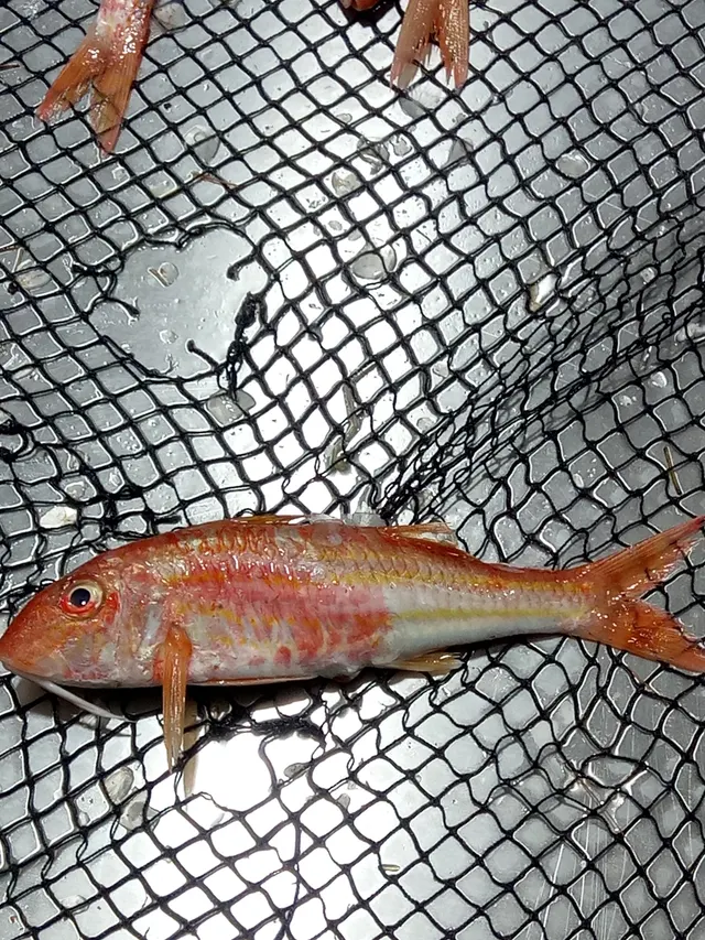 Striped red mulletA red and gold bottom-feeding fish that hunts with a pair of long chin barbels, unrelated to grey mullet and among the most prized European table fish.
Karim Haddad — CC BY, via iNaturalist
Places within this area
Publicly documented fishing geography. FishingHQ describes what the ground is; it does not say whether you may fish it, and every one of these sends that question to the body that holds the answer. Browse every place in this part of the world.
Who to ask before fishing any of these
FishingHQ does not know the current access position here. Shore angling in England is not rod-licensed, but access rights, landowner permission, local authority and harbour byelaws, national and inshore fisheries measures, and site designations all apply and all change. Check the current position with the relevant inshore fisheries and conservation authority, the harbour or local authority, and the landowner before going.
Peninnis Head
Headland · Salt water
The southern point of St Mary's: a low granite headland of weathered, rounded boulders and tors running out to a lighthouse, with gullies and ledges between them and no beach on either side of the point itself. The ground drops away hard — the water a short cast off the head is far deeper than anything comparable on the mainland's granite coast — which is why it is fished as a deep-water mark from a shore stance. The rock is the fishing: the boulder fields, holes and weed either side of the point are wrasse ground, and the drop-off at the end is where the pollack are.
Open to the south and west with the Atlantic behind it and nothing between here and Biscay. There is no shelter at the point in any southerly weather, and the granite is described by the islands' own guidance as particularly hazardous during and after rain.
Severe hazards of The Isles of Scilly apply here: cliffs and rock platforms, boat safety.
Particular to this water: Sea angling in England needs no rod licence, and that is the end of what is simple here. The archipelago has its own inshore fisheries authority with its own byelaws, much of the coast and the surrounding water carries conservation designation, and several of the headlands are nature reserves. Nothing on this page states that any ground may be fished, and no size, bag or gear limit is published here, because the byelaws are revised and FishingHQ does not track them. Ask the Isles of Scilly IFCA.
Old Town Bay
Bay · Salt water
A crescent of sand on the south coast of St Mary's, sheltered between two granite arms — Tolman Point to the east and the Peninnis headland to the west — with rock and weed on both flanks and clean ground in the middle. It is the sheltered counterpart to the exposed headland beside it: where Peninnis is fished for depth, this is fished because it is out of the swell and the rock at either end is reachable without a scramble. The islands' guidance is blunt that Scilly's beaches produce little, and the value of this bay is the rock at its edges rather than the sand between them.
South-facing but substantially sheltered by the two headlands that enclose it, which makes it the mark that is still fishable on this coast when the point outside is not.
Severe hazards of The Isles of Scilly apply here: cliffs and rock platforms, boat safety.
Particular to this water: Sea angling in England needs no rod licence, and that is the end of what is simple here. The archipelago has its own inshore fisheries authority with its own byelaws, much of the coast and the surrounding water carries conservation designation, and several of the headlands are nature reserves. Nothing on this page states that any ground may be fished, and no size, bag or gear limit is published here, because the byelaws are revised and FishingHQ does not track them. Ask the Isles of Scilly IFCA.
St Mary's Harbour and quay
Harbour wall · Salt water
The archipelago's working harbour at Hugh Town, and the one piece of Scilly fishing that needs no scramble over granite and no tide table read twice. The quay is the islands' transport hub — the mainland ferry and the inter-island boats work off it — so this is fishing around vessel movements rather than in isolation. The ground is harbour bottom and quay wall: mixed, sheltered, and shallower than anything on the open coast, with the archipelago's clear water making it a mark where fish can generally be seen before they are fished for.
Sheltered, and the most sheltered fishing in the archipelago. It is the mark that remains fishable when the Atlantic is running and the headlands are not.
Severe hazards of The Isles of Scilly apply here: cliffs and rock platforms, boat safety.
Particular to this water: A working harbour and the islands' transport hub, operated by St Mary's Harbour Authority. Fishing here is subject to whatever the harbour authority permits around vessel movements, and that is a question for the harbour rather than for this page. The Isles of Scilly IFCA — not Cornwall IFCA — makes the inshore fisheries byelaws for the archipelago. Nothing here states that this quay may be fished.
The Daymark, St Martin's
Headland · Salt water
The north-eastern end of St Martin's, at Chapel Down, under the red-and-white stone daymark that has stood on the island's highest ground since the seventeenth century. It is the outermost accessible shore ground in the inhabited archipelago on this side: granite headland falling to deep Atlantic water, exposed on three sides, with the open sea and the Eastern Isles beyond. The sources name it with the St Mary's deep-water marks and for the same reason — depth reachable from a shore stance — and it is a longer walk to less shelter than any of them.
Exposed on three sides to open Atlantic, at the outer edge of the inhabited islands. There is no shelter here in any weather with east or north in it, and the walk out is long enough that conditions can change during it.
Severe hazards of The Isles of Scilly apply here: cliffs and rock platforms, boat safety.
Particular to this water: Sea angling in England needs no rod licence, and that is the end of what is simple here. The archipelago has its own inshore fisheries authority with its own byelaws, much of the coast and the surrounding water carries conservation designation, and several of the headlands are nature reserves. Nothing on this page states that any ground may be fished, and no size, bag or gear limit is published here, because the byelaws are revised and FishingHQ does not track them. Ask the Isles of Scilly IFCA.
Safety
Cliffs and rock platforms — Can cause serious injury or death
Long-period Atlantic ground swell reaches exposed granite ledges with no shelf to bleed its energy and independently of local wind, arriving in sets. The rock is rounded, weeded and drops into deep water, so a person swept off has no shallow margin and little to grip.
What reduces it: Read the swell forecast including the period rather than the wind forecast, watch a mark through several full set cycles from above the wet line, choose a position with a way up behind it, wear a buoyancy aid, and do not fish exposed ledges alone.
Worse when:
- With Atlantic ground swell running under calm bright conditions, which is the combination that misleads visitors.
- At the outer points and the western ground, where there is no shelter of any kind.
Boat safety — Can cause serious injury or death
The shallow granite platform between and around the islands is strewn with unmarked rock, drying ledge and reef, invisible in a ripple. Tidal streams between the islands run strongly and produce overfalls over shallow ground.
What reduces it: Keep to known passages, go slowly on unfamiliar water, obtain local knowledge of the ground and the streams before travelling at speed, and plan passages around the state of the tide.
Fishing alone — Can cause injury needing treatment
The archipelago is forty kilometres offshore, help is a long way off, and weather closes the sea and air links together for days at a time. An incident is more expensive here than the same incident on the mainland.
What reduces it: Tell somebody the plan and the return time, carry a means of calling for help on the person, allow a wider margin than a mainland trip would need, and treat a decision not to go as ordinary.
Cold water shock — Can cause injury needing treatment
The water is cool rather than cold by British standards, which reduces but does not remove the cold-shock response. Immersion still produces an involuntary gasp and loss of breathing control, in deep water beside rounded weeded rock.
What reduces it: Wear a buoyancy aid rather than carry one, do not assume mild water removes the risk, and carry a means of calling for help on the person.
Further safety reading
- Rock platform and cliff safety — Long-period Atlantic ground swell reaches exposed granite ledges with no shelf to bleed its energy, arriving in sets, onto rounded weeded rock that drops into deep water with nothing to climb.
Check the rules before you fish
Fishing laws, bylaws, access rules, seasons, bait restrictions and permitted methods vary by location and can change. Check the current rules from the relevant authority and the water you intend to fish before fishing.
Check with:
- Current national or regional law for where you are fishing
- Current local bylaws
- The relevant fisheries authority
- The landowner, club or fishery whose water it is
- Any restrictions specific to the species or the method you intend to use
Where to go next
What swims here
- Ballan wrasseIn numbers and at size over the extensive shallow granite reef, which is one of the archipelago's genuine strengths and a direct consequence of a very large area of clean hard ground.
- European sea bassIn the clear shallows and around the tidal streams between the islands, where exceptional visibility makes genuine sight fishing possible — which is rare in England and changes the tackle entirely.
- John DoryAround the reef and in the clear water of the archipelago, one of several southern species that occur here with a regularity nowhere else in England matches.
- PollackOver the kelp edges and the drop-offs at the outer points and the western ground, where deep water lies immediately off the rock.
- Striped red mulletOver the clean granite sand, where the archipelago's warmer Atlantic influence supports a species that is a notable event on most of the English mainland.
- Thick-lipped grey mulletIn the harbours and shallow bays in exceptional clarity, which makes them substantially harder rather than easier to catch.
How this compares
Environment and conservation
Sources and evidence
- Cefas science, advice and data on marine and freshwater environments — Centre for Environment, Fisheries and Aquaculture Science (Government fisheries body)Relied on for: Marine environmental science for UK shelf seas, including tidal range and stream, sediment characterisation, coastal process and the monitoring programmes that describe them.States this directlyCitation checked — the work exists and is described correctly
- ICES Advice on fishing opportunities, catch and effort — International Council for the Exploration of the Sea (Scientific institute)Relied on for: Ecoregion description, stock distribution and the hydrography of the sea areas assessed.States this directlyCitation checked — the work exists and is described correctly
- JNCC species and habitat conservation advice — Joint Nature Conservation Committee (Conservation authority)Relied on for: Designation, habitat description and conservation status of the marine and coastal habitats named, and the species characteristically associated with them.States this directlyCitation checked — the work exists and is described correctly
- The Fishes of the British Isles and North-West Europe — Macmillan, 1969 (Reference work)Relied on for: Distribution, habitat association and biology of the fishes of the British Isles and north-west Europe named here.States this directlyCitation checked — the work exists and is described correctly
- RNLI water safety guidance: cold water shock and Float to Live — Royal National Lifeboat Institution (Water-safety or diver-training authority)Relied on for: Cold water shock and the immersion response, tidal cut-off, and water-safety guidance for shore anglers and small-craft users.States this directlyPassage read and verified
- Met Office shipping forecast, inshore waters forecast and marine warnings — Met Office, United Kingdom (Government fisheries body)Relied on for: That inshore waters forecasts, sea state and swell are the operative inputs for shore and small-craft decisions in these waters.States this directlyCitation checked — the work exists and is described correctly
Why the 11 connections on this page are here, and the sources
What swims here
Backed by research — 6 connections
Supported by peer-reviewed research or fisheries science. The sources are listed and can be checked.
Ballan wrasse
A claim that a place contains the ground, water and seasonal conditions the species is associated with. It is a distributional statement about the world, it rests on the regional reference literature, and it deliberately asserts nothing about access, permission or catch.
- The Fishes of the British Isles and North-West Europe — Macmillan, 1969 (Reference work)Relied on for: Distribution and habitat association of the marine, estuarine and freshwater fishes of the British Isles, including which coasts, estuaries and ground types a species occupies.States this directlyCitation checked — the work exists and is described correctly
- FishBase: a global information system on fishes — Froese, R. and D. Pauly, eds. — FishBase Consortium (Scientific institute)Relied on for: Recorded distribution, depth range and habitat association for the species named.States this directlyPassage read and verified
European sea bass
A claim that a place contains the ground, water and seasonal conditions the species is associated with. It is a distributional statement about the world, it rests on the regional reference literature, and it deliberately asserts nothing about access, permission or catch.
- The Fishes of the British Isles and North-West Europe — Macmillan, 1969 (Reference work)Relied on for: Distribution and habitat association of the marine, estuarine and freshwater fishes of the British Isles, including which coasts, estuaries and ground types a species occupies.States this directlyCitation checked — the work exists and is described correctly
- FishBase: a global information system on fishes — Froese, R. and D. Pauly, eds. — FishBase Consortium (Scientific institute)Relied on for: Recorded distribution, depth range and habitat association for the species named.States this directlyPassage read and verified
John Dory
A claim that a place contains the ground, water and seasonal conditions the species is associated with. It is a distributional statement about the world, it rests on the regional reference literature, and it deliberately asserts nothing about access, permission or catch.
- The Fishes of the British Isles and North-West Europe — Macmillan, 1969 (Reference work)Relied on for: Distribution and habitat association of the marine, estuarine and freshwater fishes of the British Isles, including which coasts, estuaries and ground types a species occupies.States this directlyCitation checked — the work exists and is described correctly
- FishBase: a global information system on fishes — Froese, R. and D. Pauly, eds. — FishBase Consortium (Scientific institute)Relied on for: Recorded distribution, depth range and habitat association for the species named.States this directlyPassage read and verified
Pollack
A claim that a place contains the ground, water and seasonal conditions the species is associated with. It is a distributional statement about the world, it rests on the regional reference literature, and it deliberately asserts nothing about access, permission or catch.
- The Fishes of the British Isles and North-West Europe — Macmillan, 1969 (Reference work)Relied on for: Distribution and habitat association of the marine, estuarine and freshwater fishes of the British Isles, including which coasts, estuaries and ground types a species occupies.States this directlyCitation checked — the work exists and is described correctly
- FishBase: a global information system on fishes — Froese, R. and D. Pauly, eds. — FishBase Consortium (Scientific institute)Relied on for: Recorded distribution, depth range and habitat association for the species named.States this directlyPassage read and verified
Striped red mullet
A claim that a place contains the ground, water and seasonal conditions the species is associated with. It is a distributional statement about the world, it rests on the regional reference literature, and it deliberately asserts nothing about access, permission or catch.
- The Fishes of the British Isles and North-West Europe — Macmillan, 1969 (Reference work)Relied on for: Distribution and habitat association of the marine, estuarine and freshwater fishes of the British Isles, including which coasts, estuaries and ground types a species occupies.States this directlyCitation checked — the work exists and is described correctly
- FishBase: a global information system on fishes — Froese, R. and D. Pauly, eds. — FishBase Consortium (Scientific institute)Relied on for: Recorded distribution, depth range and habitat association for the species named.States this directlyPassage read and verified
Thick-lipped grey mullet
A claim that a place contains the ground, water and seasonal conditions the species is associated with. It is a distributional statement about the world, it rests on the regional reference literature, and it deliberately asserts nothing about access, permission or catch.
- The Fishes of the British Isles and North-West Europe — Macmillan, 1969 (Reference work)Relied on for: Distribution and habitat association of the marine, estuarine and freshwater fishes of the British Isles, including which coasts, estuaries and ground types a species occupies.States this directlyCitation checked — the work exists and is described correctly
- FishBase: a global information system on fishes — Froese, R. and D. Pauly, eds. — FishBase Consortium (Scientific institute)Relied on for: Recorded distribution, depth range and habitat association for the species named.States this directlyPassage read and verified
How people fish here
What experienced anglers do — 2 connections
Widely and independently recommended by experienced anglers and specialist sources. This is real angling knowledge, not proof: controlled evidence for it is limited, and FishingHQ records it as convention rather than as a demonstrated effect.
Lure fishing
A claim about angling convention rather than about the world: that this place sits within this branch of fishing, which drives the information architecture as well as the page. It rests on independent practitioner description.
- General angling website restatements of established technique — Various (Credible secondary source)Relied on for: Widely restated descriptions of which practices are conventionally used in the waters named, recorded as practitioner consensus rather than as scholarship.Background and mechanism onlyCitation checked — the work exists and is described correctly
- Sea Angler — Bauer Media (Specialist angling publication)Relied on for: Long-running published description of British and Irish sea angling practice by region and by ground type.FishingHQ's interpretation of what it saysCitation checked — the work exists and is described correctly
Sea fishing
A claim about angling convention rather than about the world: that this place sits within this branch of fishing, which drives the information architecture as well as the page. It rests on independent practitioner description.
- General angling website restatements of established technique — Various (Credible secondary source)Relied on for: Widely restated descriptions of which practices are conventionally used in the waters named, recorded as practitioner consensus rather than as scholarship.Background and mechanism onlyCitation checked — the work exists and is described correctly
- Sea Angler — Bauer Media (Specialist angling publication)Relied on for: Long-running published description of British and Irish sea angling practice by region and by ground type.FishingHQ's interpretation of what it saysCitation checked — the work exists and is described correctly
How this compares
What experienced anglers do — 1 connection
Widely and independently recommended by experienced anglers and specialist sources. This is real angling knowledge, not proof: controlled evidence for it is limited, and FishingHQ records it as convention rather than as a demonstrated effect.
Canary Islands
A claim that two places are worth reading against one another, because a reader choosing between them or generalising from one to the other needs to know how the underlying process differs.
- General angling website restatements of established technique — Various (Credible secondary source)Relied on for: Widely restated descriptions of which practices are conventionally used in the waters named, recorded as practitioner consensus rather than as scholarship.Background and mechanism onlyCitation checked — the work exists and is described correctly
- Sea Angler — Bauer Media (Specialist angling publication)Relied on for: Long-running published description of British and Irish sea angling practice by region and by ground type.FishingHQ's interpretation of what it saysCitation checked — the work exists and is described correctly
Safety reading
Official guidance — 1 connection
Stated by a fisheries authority, scientific institute or recognised angling body. Authoritative, but summarising rather than demonstrating.
Rock platform and cliff safety
A claim that a place presents a particular hazard strongly enough that the reader should be sent to the page dealing with it in full, rather than left with the short warning on the place itself.
- RNLI water safety guidance: cold water shock and Float to Live — Royal National Lifeboat Institution (Water-safety or diver-training authority)Relied on for: Cold water shock and the immersion response, tidal cut-off, and water-safety guidance for shore anglers and small-craft users.States this directlyPassage read and verified
Environment and conservation
Backed by research — 1 connection
Supported by peer-reviewed research or fisheries science. The sources are listed and can be checked.
Marine protected areas and spearfishing
A claim that a place raises a particular environmental question, resting on the scientific and conservation literature for the system rather than on angling practice.
- JNCC species and habitat conservation advice — Joint Nature Conservation Committee (Conservation authority)Relied on for: Habitat classification and description for the intertidal, coastal, estuarine and freshwater habitats named, and the species characteristically associated with them.States this directlyCitation checked — the work exists and is described correctly
- Cefas science, advice and data on marine and freshwater environments — Centre for Environment, Fisheries and Aquaculture Science (Government fisheries body)Relied on for: Characterisation of UK inshore sediment, intertidal habitat, estuarine process and the shellfish beds associated with them.States this directlyCitation checked — the work exists and is described correctly
How FishingHQ labels evidence is explained in the evidence policy.