The Waterford coast
Fishing regions · Last reviewed 2026-08-27
A bass and surf coast whose best documentation is a list of what is NOT caught there — no whiting in Whiting Bay, painted ray but no thornback, and a back strand that is not bass ground.
Safety: cold water shock — can cause serious injury or death. 8 more points apply here.
Fishing here at a glance
- Ways to fish
- From the shore
- Plan a trip
- When is best · Baits and lures to bring · Open the trip planner
- Rules and access
- Who sets the rules here — being listed is never permission to fish.
Not documented here yet: tackle shops, charters or guides.
Being listed here is not permission to fish. What that meansClose
Access, fishing rights, seasons, licences, local bylaws and permitted methods vary and can change. Check current access, permission, local regulations, closures and restrictions before you travel or fish. FishingHQ describes what the ground is and names who holds the answer; it does not hold the answer itself.
Find the authority for a jurisdiction · What FishingHQ does and does not cover
The Waterford coast runs from the Youghal side round Ardmore and Dungarvan Bay, along the Copper Coast, past Tramore to Waterford Harbour, and it is primarily a surf and bass coast with rock marks punctuating it.
WHAT MAKES ITS DOCUMENTATION UNUSUAL IS THE ABSENCES. The practitioner directory covering this county is unusually specific about what is NOT caught where: a bay named for whiting that holds none, a premier surf beach that produces painted ray in summer and explicitly not thornback, a back strand behind a famous bass beach where the advice is to forget bass entirely, and a channel mark that no longer produces bass except off one set of rocks. A directory prepared to write down an absence is a directory whose presences are worth more, and it is the reason this coast's positive claims are carried at strength.
THE SURF IS THE FISHERY. The characteristic Waterford session is a moderate to strong surf after dark, at high or low water rather than the middle of the tide, for bass — often large — with flatfish alongside, and crab named repeatedly as the bait that matters. On one estuarine mark the source states flatly that crab is the only bait worth using.
THE COPPER COAST IS ROCK AND COVE. Between the beaches the coast is cliff, headland and small cove: mackerel, garfish, wrasse, pollack, coalfish, conger and bull huss over very foul ground, with bass for a short window either side of high water at the headland positions, and a sheltered pier alternative for the days the rock is impossible.
THE CURRENTS IN THE ESTUARY ARE EXCEPTIONAL. One mark inside the harbour is described as running a stream ferocious enough to sweep six-ounce grip leads at all states, which is a statement about a mark and also a warning about it.
AND THE BACK STRAND BEHIND THE MAIN SURF BEACH IS A DIFFERENT WATER ENTIRELY: a shallow tidal lagoon holding mullet in the low-water channel and rafts of flounder, immediately behind a beach that is one of the better-known bass venues in the country.
What fishing here is like
A south-facing surf and bass coast with hard rock between the beaches. The beaches are the fishery and they are fished in a specific way — in a moderate to strong surf, after dark, at high or low water rather than through the middle of the tide, on crab. Between them the Copper Coast is cliff, headland and cove with very foul ground and a rough-ground species list, and at either end sit a large shallow bay and a substantial harbour with strong tidal streams and a lagoon behind the main beach.
The local documentation is unusually precise about what does not happen here as well as what does, and that is what makes it usable.
What you can target here
One entry per fish, grouped by how you would be fishing — because the answer is a different one from the rocks and from a boat. Each entry says how strongly the sources support it and how much evidence sits behind it. These are documented catches, not a forecast, and none of it is a statement that you may fish any particular ground.
From the shore · 20
 Atlantic mackerelRegular local target3 placesHelvick Head, Passage East, Dunmore EastOver harbour wall, headland, tidal channelAround Jun–Sept
Photo: Hans Hillewaert, via Wikimedia Commons, CC BY-SA 4.0; resized
 European flounderRegular local target3 placesBallyquin Strand, Tramore Strand, Passage EastOver surf beach, tidal channel
Photo: nbasargin, via iNaturalist, CC BY; resized and trimmed to fit
 European sea bassRegular local target3 placesBallyquin Strand, Helvick Head, Tramore StrandOver headland, surf beach
Photo: Julien Renoult, via Wikimedia Commons, CC BY 4.0; resized and trimmed to fit
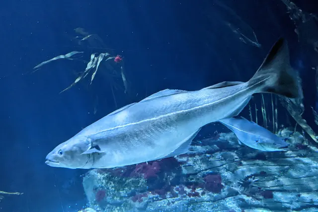 SaitheRegular local target3 placesHelvick Head, Passage East, Ballyquin StrandOver headland, surf beach, tidal channel
Photo: Wilhelm Thomas Fiege, via Wikimedia Commons, CC BY-SA 4.0; resized and trimmed to fit
- Small-spotted catsharkRegular local target3 placesBallyquin Strand, Passage East, Helvick HeadOver headland, surf beach, tidal channel
 WhitingRegular local target3 placesPassage East, Ballyquin Strand, Helvick HeadOver headland, surf beach, tidal channelAround Jan–Mar, Nov–Dec
Photo: rmjb, via iNaturalist, CC BY; resized and trimmed to fit


.jpg)
Also documented from the shore: Atlantic cod · Ballan wrasse · Brown trout · Conger eel · Dab · European plaice · Garfish · Pollack · Thick-lipped grey mullet · Bull huss · Common sole · Grey gurnard · Small-eyed ray · Thornback ray
What these strengths mean
- Regular local target
- Fishing sources describe this as a normal local target here, not merely as caught.
- Occasional
- Caught here, and described as unusual rather than normal. Do not plan a session around it.
- How breadth is counted
- A fish documented at six marks is shown as six marks: breadth never raises the strength on its own. A fishery account describes the fishing; a recorded catch reports one specific catch. How evidence is weighed.
How people fish here
5 methods are recorded on the places documented here, counted from those places themselves rather than from what is practised in the country. Each opens a full guide to the technique.
Ledgering
Recorded at 5 places here, over surf beach, harbour wall, headland, tidal channel.
Fishing a bait on the bottom held by a weight, with no float — the simplest way to fish at distance, in depth, or in wind.
Documented on the same ground: Atlantic cod, Atlantic mackerel, Ballan wrasse, Brown trout, Bull huss, Common sole.
Float fishing
Recorded at 2 places here, over harbour wall, headland.
Suspending a bait at a controlled depth beneath a buoyant indicator — the most visual, most controllable and most widely applicable method in angling.
Documented on the same ground: Atlantic cod, Atlantic mackerel, Ballan wrasse, Bull huss, Conger eel, European sea bass.
Spinning
Recorded at 2 places here, over headland, surf beach.
Casting an artificial lure and retrieving it so that it moves like something alive — the most direct form of lure fishing.
Documented on the same ground: Atlantic cod, Atlantic mackerel, Ballan wrasse, Brown trout, Bull huss, Conger eel.
Surfcasting
Recorded at 2 places here, over surf beach.
Casting heavy baited tackle from a beach into surf — a method defined by distance, by tide, and by reading water that all looks the same.
Documented on the same ground: Brown trout, Common sole, Dab, European flounder, European plaice, European sea bass.
Feathering and multi-lure traces
Recorded at 1 place here, over harbour wall.
A string of small lures on droppers, worked in the water column — how most people in Britain and Ireland catch their first sea fish, and the method most likely to catch far more than anybody intended.
Documented on the same ground: Garfish, Pollack, Thick-lipped grey mullet, Atlantic mackerel, Conger eel.
These are the methods documented at the places FishingHQ holds here. A species listed beside a method is documented on the same ground, which is not the same as being taken that way — where a source establishes the method a fish was caught on, it is stated on that place’s own page. All fishing methods.
Baits and lures for these fish
The methods, baits and lures each of the fish above is commonly taken on, from that fish’s own page. This is what works for the fish, not a report of what people use on this particular water — local knowledge and the conditions on the day still decide.
Methods
- Drift fishing — for Small-spotted catshark, Atlantic cod, Dab, European plaice and 2 more
- Jigging — for Saithe, Atlantic cod, Pollack, Grey gurnard
- Saltwater fly fishing — for European sea bass, Garfish, Pollack, Thick-lipped grey mullet
- Kayak fishing — for Atlantic mackerel, Atlantic cod, Pollack
- Deadbaiting — for Conger eel
- Drop shotting — for Ballan wrasse
- Dry fly fishing — for Brown trout
- Float-tube fishing — for Brown trout
Also: Popping and stickbaiting · Salmon fly fishing · Tenkara · Trolling
Baits
- Fish strip and cut bait — for Small-spotted catshark, Atlantic cod, Conger eel, Thick-lipped grey mullet and 3 more
- Ragworm — for European flounder, European sea bass, Small-spotted catshark, Ballan wrasse and 3 more
- Lugworm — for Whiting, Atlantic cod, Dab, European plaice and 1 more
- Squid and cuttlefish — for Small-spotted catshark, Atlantic cod, Conger eel, Dab and 1 more
- Sand eel — for European sea bass, Saithe, Pollack, Small-eyed ray
- Crab and shellfish — for European sea bass, Saithe, Ballan wrasse
- Peeler crab — for European flounder, European sea bass, Atlantic cod
- Sea deadbaits — for Small-spotted catshark, Bull huss
Also: Bread · Prawns and shrimp
Lures
- Metal jigs — for Atlantic mackerel, European sea bass, Saithe, Atlantic cod and 1 more
- Soft plastics — for European sea bass, Saithe, Atlantic cod, Ballan wrasse and 1 more
- Streamers — for European sea bass, Brown trout
- Dry flies — for Brown trout
- Jerkbaits — for European sea bass
- Jigs and jig heads — for Pollack
- Nymphs — for Brown trout
- Spinners — for Atlantic mackerel
Also: Surface lures · Terrestrial fly patterns · Wet flies
The fishing year here
The months the places and accounts under this area actually name, tightest season first. This is “observed in these months” rather than a season: a species whose months nobody recorded is not listed, because a gap in the evidence is not a year-round fishery.
- Atlantic mackerelJune to September
- GarfishJune to September
- Thick-lipped grey mulletJune to September
- Small-eyed rayJune to September
- WhitingNovember to March
- Atlantic codNovember to March
What dominates
Surf fishing for bass, dabs, flounder, small plaice, sole and dogfish, at night, in surf, on peeler crab with lugworm, squid and mackerel as alternatives. Rock and headland fishing for mackerel, garfish, wrasse, pollack, coalfish, conger and bull huss, with bass in a short window either side of high water. Spinning and float fishing from the piers and rocks for sea trout, mackerel and small pollack, with summer mullet in the harbours. Bottom fishing in the estuary and bay for flounder, bass and dogfish, and for winter codling on a long cast. Light float fishing for mullet in the back-strand channels. Charter and small-boat fishing from the harbours.
The water available
Long south-facing surf beaches of sand, several backed by dune. A hard rock coast of cliff, headland and small cove between them, with heavily foul ground close in. A large shallow tidal bay with mud, sand and channels. A shallow tidal lagoon behind one of the main beaches, holding mullet and flounder. A substantial harbour and river estuary with exceptionally strong tidal streams. Sheltered piers that fish when the rock cannot.
How the rules are structured
Sea angling is unlicensed and governed by sizes, bag limits, protected species and area measures. Bass carries specific and long-standing national conservation measures including a size limit, a bag limit and a closed period, and this is a bass coast, so it is the measure most likely to apply to a visiting angler here. Salmon and sea trout require a state licence and are managed river by river on annual assessment. Shellfish gathering is governed by classification and biotoxin monitoring, which applies to the bay and the back strand. Conservation designations cover the bay, the lagoon and several of the dune systems. FishingHQ does not state what any current rule is: establish licensing, sizes, bag limits, closed periods and any protected-area constraint with the statutory bodies before fishing.
Who to ask
- Inland Fisheries Ireland, for freshwater fisheries, for salmon and sea trout licensing and tagging, and for the sea angling conservation measures it administers.
- The government department responsible for the marine, and the Sea-Fisheries Protection Authority, for sea fisheries measures, minimum sizes, bag limits and protected species.
- The National Parks and Wildlife Service, where a designation constrains access, disturbance or collection.
- The Food Safety Authority of Ireland and the shellfish classification and biotoxin monitoring programme, before anything filter-feeding is taken.
- The harbour authority, local authority, club or landowner controlling the specific structure or shore, whose permission is theirs to give and is not stated here.
- The Irish Coast Guard and the RNLI, for safety guidance on this coast.
Words you will meet
- Back strand
- The shallow tidal lagoon enclosed behind a barrier beach. A different water from the beach in front of it, with a different species list, and the local advice is explicit that what works on one does not work on the other.
- Grip lead
- A lead with wires that grip the bottom against tide and surf. Where a source says a mark sweeps a six-ounce grip lead, it is describing a current that ordinary beach tackle cannot hold in.
- A moderate surf
- The condition this coast's bass fishing is described against: enough broken water to colour the surf table and move food, but not so much that a bait cannot be held. It is a fishing condition rather than a weather one.
Conditions and hazards
This is a night-fishing coast, because that is when the surf beaches produce, and everything else follows from that. Cold water, a rising or falling tide over flat sand in the dark, and a walk back over dune with wet gear.
The estuary and harbour carry exceptional tidal streams — one documented as sweeping six-ounce grip leads at all states — and moving water of that strength beside a shelving bank is not somewhere to wade or to stand close to.
The Copper Coast rock is cliff-backed with very foul ground, slippery ledges and awkward descents, and the headland marks that fish for bass around high water are exactly the ones the tide takes back first.
The water is cold enough for cold water shock year round, and surf strong enough to fish in is surf strong enough to knock somebody over.
Some of what lives here
Fish recorded here that FishingHQ holds a reviewed photograph of. It is not a complete list of what The Waterford coast holds, and it is not a prediction that you will catch any of them — it is a way in to the ones we can show you.
- European sea bassA fast, predatory inshore fish that hunts in broken water and surf, and one of the most closely managed recreational species in European seas.
Photo: Julien Renoult, via Wikimedia Commons, CC BY 4.0; resized and trimmed to fit
- European flounderThe flatfish that runs up rivers — a tolerant, estuarine right-eyed flounder with bony tubercles along its fin bases and a habit of turning up in fresh water.
Photo: nbasargin, via iNaturalist, CC BY; resized and trimmed to fit
 Thick-lipped grey mulletA shoaling coastal fish that eats algae and detritus rather than prey — which makes it the hardest common sea fish to catch and the most interesting to think about.
Photo: Diego Delso, via Wikimedia Commons, CC BY-SA 4.0; resized and trimmed to fit
 Ballan wrasseA long-lived rocky-ground resident that begins life female and may change sex — and the species that turned rock marks into a lure fishery.
Photo: Diego Delso, via Wikimedia Commons, CC BY-SA 4.0; resized and trimmed to fit
 Atlantic codA large, heavily-built demersal predator of the North Atlantic, and the species whose commercial history is the standard example of stock collapse.
Photo: The U.S. Food and Drug Administration, via Wikimedia Commons, public domain; resized and trimmed to fit
,_Catania,_Sicilia,_Italia,_2025-04-04,_DD_63.jpg)
,_isla_de_Mouro,_Santander,_Espa%C3%B1a,_2019-08-15,_DD_55.jpg)
.jpg)
Places within this area
Publicly documented fishing geography. FishingHQ describes what the ground is; it does not say whether you may fish it, and every one of these sends that question to the body that holds the answer. Browse every place in this part of the world.
Who to ask before fishing any of these
FishingHQ does not know the current access position here. Sea angling in Ireland is not generally licensed, but access rights, landowner permission, harbour and local authority rules, conservation designations and national fisheries measures all apply and all change. Check the current position with Inland Fisheries Ireland, the harbour or local authority and the landowner before going.
Dunmore East
Harbour wall · Salt water
A working fishing harbour at the mouth of Waterford estuary, with a substantial breakwater on old red sandstone cliffs, deep water alongside the outer arm and rock and weed either side.
Severe hazards of The Waterford coast apply here: cold water shock, moving water and currents, tides and being cut off.
Particular to this water: This is an owned and operated structure. Whether angling is allowed on it, when, from where and on what terms is the operator's decision, is frequently seasonal, and changes without notice.
Ballyquin Strand
Surf beach · Salt water
A sand beach about eight kilometres west of Mine Head, split by a low outcrop known as the Black Rocks, with clean sand either side and the middle section between the rocks fishing separately.
Open to the south on the Waterford coast, and little used — the practitioner directory calls it one of the premier shore venues in Ireland and lightly fished in the same paragraph.
Particular to this ground: cold water shock.
Severe hazards of The Waterford coast apply here: moving water and currents, tides and being cut off.
Helvick Head
Headland · Salt water
A steep rock headland closing the southern side of Dungarvan Bay, with a pier tucked under it and very foul ground off the rock below. The pier is sheltered and the head is not.
The head takes the weather from the south and east; the pier under it is the shelter, and the practitioner directory describes them as a pair for that reason.
Particular to this ground: cliffs and rock platforms, cold water shock.
Severe hazards of The Waterford coast apply here: moving water and currents, tides and being cut off.
Tramore Strand
Surf beach · Salt water
A long south-facing sand beach running east from Tramore town to the dunes at Saleens, with the back strand and its salt marsh behind. Clean sand with deep gullies in the beach at the dune end.
Fully open to the south and to the swell running into Tramore Bay, and it needs a moderate to strong surf to fish.
Particular to this ground: cold water shock.
Severe hazards of The Waterford coast apply here: moving water and currents, tides and being cut off.
Passage East
Tidal channel · Salt water
A village on the western shore of Waterford Harbour where the estuary narrows and deep water runs close to the quay. Mud and sand with a hard channel, and a car ferry crossing the mark itself.
Inside Waterford Harbour and sheltered, with the weather that matters being wind against tide.
Severe hazards of The Waterford coast apply here: cold water shock, moving water and currents, tides and being cut off.
Particular to this water: A working car ferry slip and village quay. The directory also records that a seal population uses the main channel, which is a fact about the fishing rather than a hazard.
Safety
Cold water shock — Can cause serious injury or death
The water is cold enough to trigger the involuntary gasp and hyperventilation of cold water shock for most of the year, which incapacitates a swimmer in the first minute regardless of how well they swim, and it does not stop being cold in a warm summer week.
What reduces it: Wear a buoyancy aid so the first minute does not have to be survived by swimming. Fish with somebody. Know where you would get out before you need to.
Moving water and currents — Can cause serious injury or death
Narrow sounds, estuary mouths, harbour entrances and channel edges run hard on the tide, and the water moving through them is a whole bay emptying and filling through a gap. Somebody who enters that water is carried, not swum, and shingle and sandbanks shift under the current.
What reduces it: Treat the state of the tide as part of the mark rather than as a timing detail. Do not wade a channel edge. Stay off shifting banks on a making tide.
Tides and being cut off — Can cause serious injury or death
Tidal islands, causeways, strand crossings and rock gullies that are dry ground at low water flood on the tide, and the water arrives behind the angler rather than in front of them. The Irish west and south coasts carry a large number of these and several are the ordinary way onto a mark.
What reduces it: Work out the tide for the day before walking out, and work out the exit rather than the entrance. Set an alarm for the turn. Never assume a crossing that was dry on the way out will be dry on the way back.
Slips, trips and falls — Can cause injury needing treatment
Wet rock, weed-covered ledges, boulder shores and steep descents to the water. Falls here produce broken ankles and head injuries, and they happen on the walk rather than in the fishing.
What reduces it: Boots with a stiff sole and real grip, both hands free on a descent, and a route down chosen in daylight if the session runs into darkness.
Weather and lightning — Can cause injury needing treatment
Weather on this coast changes faster than a forecast granularity of a few hours can express, and a wind shift onshore turns a fishable platform into an unfishable one inside a session.
What reduces it: Check the forecast for the coast rather than the county, watch the sky and the sea rather than only the phone, and leave early rather than late.
Precautions that always apply here
- Wear a buoyancy aid or lifejacket. Cold water incapacitates strong swimmers within a minute, long before swimming ability matters.
- Check the tide before you go and know your exit route. Being cut off is the commonest way a shore session becomes a rescue.
- Tell somebody where you are going and when you expect to be back.
- Carry a charged phone in a waterproof case, or another means of calling for help.
Further safety reading
- Night fishing safety — This is a night-fishing coast because that is when the surf beaches produce, and everything else follows from it: cold water, a moving tide over flat sand in the dark, and a walk back over dune with wet gear.
Check the rules before you fish
Fishing laws, bylaws, access rules, seasons, bait restrictions and permitted methods vary by location and can change. Check the current rules from the relevant authority and the water you intend to fish before fishing.
Check with:
- Current national or regional law for where you are fishing
- Current local bylaws
- The relevant fisheries authority
- The landowner, club or fishery whose water it is
- Any restrictions specific to the species or the method you intend to use
Where to go next
What swims here
- Atlantic codA winter fishery on this coast, taken at long range from the beaches rather than close in, and secondary to the bass fishing the coast is known for.
- Ballan wrasseOver the very foul ground of the Copper Coast headlands between the beaches, with conger and bull huss on the same ground.
- European flounderThrough the surf beaches and, in rafts, in the shallow tidal lagoon behind the main beach — which is a different water from the beach in front of it and holds a different fishery.
- European sea bassThe species this coast is fished for, and the association is with a CONDITION rather than a place: a moderate to strong surf, after dark, at high or low water rather than through the middle of the tide, on peeler crab. Irish bass carries restrictive national conservation measures of long standing.
1 more
Local knowledge
- Fishing the surfThe characteristic session on this coast is defined by surf state rather than by season or mark: enough broken water to colour the table and move food, but not so much that a bait cannot be held. Where a local source says a mark sweeps a six-ounce grip lead, it is describing water that ordinary beach tackle cannot hold in.
Sources and evidence
- Sea Angling in Ireland: the shore marks of Waterford — Sea Angling Ireland (Credible secondary source)Relied on for: A practitioner shore directory's account of the Waterford coast, the Copper Coast and Waterford Harbour: the ground, the species, the methods, the tide windows and the character of the fishing, recorded as practitioner consensus rather than as tested fact.Background and mechanism onlyPassage read and verified
- Inland Fisheries Ireland: South West Sea Angling Guide — Cork Harbour to Mine Head — Inland Fisheries Ireland, 2020 (Government fisheries body)Relied on for: The statutory fisheries body's own sea angling guide to the coast east from Cork Harbour to Mine Head, mark by mark, with the species and the state of the tide.Background and mechanism onlyPassage read and verified
- The Fishes of the British Isles and North-West Europe — Macmillan, 1969 (Reference work)Relied on for: Distribution, habitat association and biology of the fishes of the British Isles and north-west Europe named as characteristic of this coast.Background and mechanism onlyCitation checked — the work exists and is described correctly
Why the 8 connections on this page are here, and the sources
What swims here
Backed by research — 5 connections
Supported by peer-reviewed research or fisheries science. The sources are listed and can be checked.
Atlantic cod
A claim that a coast contains the ground and conditions the species is associated with. It is a distributional statement about the world, it rests on the regional reference literature, and it deliberately asserts nothing about access, permission or catch.
- The Fishes of the British Isles and North-West Europe — Macmillan, 1969 (Reference work)Relied on for: Distribution and habitat association of the marine and estuarine fishes of the British Isles and north-west Europe, including which coasts and ground types a species occupies.States this directlyCitation checked — the work exists and is described correctly
- FishBase: a global information system on fishes — Froese, R. and D. Pauly, eds. — FishBase Consortium (Scientific institute)Relied on for: Recorded distribution, depth range and habitat association for the species named.States this directlyPassage read and verified
Ballan wrasse
A claim that a coast contains the ground and conditions the species is associated with. It is a distributional statement about the world, it rests on the regional reference literature, and it deliberately asserts nothing about access, permission or catch.
- The Fishes of the British Isles and North-West Europe — Macmillan, 1969 (Reference work)Relied on for: Distribution and habitat association of the marine and estuarine fishes of the British Isles and north-west Europe, including which coasts and ground types a species occupies.States this directlyCitation checked — the work exists and is described correctly
- FishBase: a global information system on fishes — Froese, R. and D. Pauly, eds. — FishBase Consortium (Scientific institute)Relied on for: Recorded distribution, depth range and habitat association for the species named.States this directlyPassage read and verified
European flounder
A claim that a coast contains the ground and conditions the species is associated with. It is a distributional statement about the world, it rests on the regional reference literature, and it deliberately asserts nothing about access, permission or catch.
- The Fishes of the British Isles and North-West Europe — Macmillan, 1969 (Reference work)Relied on for: Distribution and habitat association of the marine and estuarine fishes of the British Isles and north-west Europe, including which coasts and ground types a species occupies.States this directlyCitation checked — the work exists and is described correctly
- FishBase: a global information system on fishes — Froese, R. and D. Pauly, eds. — FishBase Consortium (Scientific institute)Relied on for: Recorded distribution, depth range and habitat association for the species named.States this directlyPassage read and verified
European sea bass
A claim that a coast contains the ground and conditions the species is associated with. It is a distributional statement about the world, it rests on the regional reference literature, and it deliberately asserts nothing about access, permission or catch.
- The Fishes of the British Isles and North-West Europe — Macmillan, 1969 (Reference work)Relied on for: Distribution and habitat association of the marine and estuarine fishes of the British Isles and north-west Europe, including which coasts and ground types a species occupies.States this directlyCitation checked — the work exists and is described correctly
- FishBase: a global information system on fishes — Froese, R. and D. Pauly, eds. — FishBase Consortium (Scientific institute)Relied on for: Recorded distribution, depth range and habitat association for the species named.States this directlyPassage read and verified
Thick-lipped grey mullet
A claim that a coast contains the ground and conditions the species is associated with. It is a distributional statement about the world, it rests on the regional reference literature, and it deliberately asserts nothing about access, permission or catch.
- The Fishes of the British Isles and North-West Europe — Macmillan, 1969 (Reference work)Relied on for: Distribution and habitat association of the marine and estuarine fishes of the British Isles and north-west Europe, including which coasts and ground types a species occupies.States this directlyCitation checked — the work exists and is described correctly
- FishBase: a global information system on fishes — Froese, R. and D. Pauly, eds. — FishBase Consortium (Scientific institute)Relied on for: Recorded distribution, depth range and habitat association for the species named.States this directlyPassage read and verified
How people fish here
What experienced anglers do — 1 connection
Widely and independently recommended by experienced anglers and specialist sources. This is real angling knowledge, not proof: controlled evidence for it is limited, and FishingHQ records it as convention rather than as a demonstrated effect.
Sea fishing
A statement about which branch of angling dominates on a coast. It is consensus about practice rather than a fact about the world, and it is carried at that level.
- Inland Fisheries Ireland regional sea angling guides — Inland Fisheries Ireland, 2013 (Government fisheries body)Relied on for: The Irish statutory fisheries body's own sea angling guides, describing the marks of each coast with the species taken and the state of the tide.Background and mechanism onlyPassage read and verified
- General angling website restatements of established technique — Various (Credible secondary source)Relied on for: Widely restated practice and local fishing character for these coasts, recorded as practitioner consensus rather than as tested fact.Background and mechanism onlyCitation checked — the work exists and is described correctly
Local knowledge
Backed by research — 1 connection
Supported by peer-reviewed research or fisheries science. The sources are listed and can be checked.
Fishing the surf
A link from a coast to the physical mechanism that governs its fishing, which is a claim about coastal process or hydrography rather than about angling.
- ICES Advice on fishing opportunities, catch and effort — International Council for the Exploration of the Sea (Scientific institute)Relied on for: Ecoregion description, stock distribution and the hydrography of the sea areas named, including seasonal inshore movement.States this directlyCitation checked — the work exists and is described correctly
- Cefas science, advice and data on marine and freshwater environments — Centre for Environment, Fisheries and Aquaculture Science (Government fisheries body)Relied on for: Marine environmental science for north-west European shelf seas, including sediment character, coastal process and inshore monitoring.States this directlyCitation checked — the work exists and is described correctly
Safety reading
Official guidance — 1 connection
Stated by a fisheries authority, scientific institute or recognised angling body. Authoritative, but summarising rather than demonstrating.
Night fishing safety
A statement that a coast presents a particular hazard, resting on water-safety guidance issued by bodies with responsibility for it rather than on angling practice.
- RNLI water safety guidance: cold water shock and Float to Live — Royal National Lifeboat Institution (Water-safety or diver-training authority)Relied on for: Cold water shock, immersion response, tidal cut-off and water-safety guidance for shore anglers and small-craft users.States this directlyPassage read and verified
- Rock fishing safety and the declared lifejacket areas of New South Wales — NSW Department of Primary Industries and Surf Life Saving NSW (Water-safety or diver-training authority)Relied on for: Rock-platform hazards, the mechanism by which anglers are swept, and the measures that address it.States this directlyCitation checked — the work exists and is described correctly
How FishingHQ labels evidence is explained in the evidence policy.