Scottish sea lochs
Fishing regions · Last reviewed 2026-08-15
Glacial fjords with a shallow sill across the mouth. The sill is the whole point: it makes the deep water behind it a partly separate sea with its own temperature, its own oxygen and its own fish.
Safety: moving water and currents — can cause serious injury or death. 9 more points apply here.
Being listed here is not permission to fish. What that meansClose
Access, fishing rights, seasons, licences, local bylaws and permitted methods vary and can change. Check current access, permission, local regulations, closures and restrictions before you travel or fish. FishingHQ describes what the ground is and names who holds the answer; it does not hold the answer itself.
Find the authority for a jurisdiction · What FishingHQ does and does not cover
A Scottish sea loch is a fjord — a valley cut by ice and drowned by the sea — and it is a system-tier case because one piece of geometry, the sill, explains almost everything about how it behaves.
THE SILL IS A SHALLOW BAR ACROSS THE MOUTH. Glaciers cut deepest where they were thickest and shallowest where they spread out at the end, so a fjord is typically deep in its basin and shallow at its entrance. That shallow threshold is the sill, and it partially isolates the deep water behind it from the open sea.
WHICH MAKES THE DEEP BASIN A SEPARATE BODY OF WATER. Water in the basin below sill depth is not freely exchanged with the sea outside. It is renewed only when conditions outside push denser water over the sill, which may happen seasonally, occasionally, or in some lochs rarely. Between renewals the basin water sits, warms or cools on its own schedule, and — critically — has its oxygen consumed without being replenished. Some sea loch basins are naturally low in oxygen at depth for that reason.
FRESH WATER FLOATS ON TOP OF IT. Rivers and hill burns discharge into the head of the loch, and fresh water is less dense than salt, so it forms a brackish surface layer that flows seaward while denser salt water moves landward beneath it. That two-layer circulation is characteristic and it puts a genuine salinity gradient along the length of the loch — nearly fresh at the head, fully marine at the mouth.
THE FISHING FOLLOWS THE STRUCTURE. Shelter is the first fact: a sea loch is fishable in weather that closes the open coast entirely, which makes it the small-boat and kayak water of the west. The sill and the narrows carry strong tidal streams and concentrate food and predators. The deep basins hold species that need depth — spurdog, skate, conger, whiting — and gave rise to a specialist deep-water fishery. The shallow heads and their brackish gradients hold sea trout, mullet and flounder. Kelp and reef along the sides hold pollack, wrasse and coalfish.
AND THE COMMON SKATE IS THE SPECIES THIS SYSTEM IS BEST KNOWN FOR. A critically endangered elasmobranch that survives in numbers in some west coast sea lochs, supporting a strictly catch-and-release fishery built around tagging and research. It is one of the clearest cases anywhere of angling and conservation operating as the same activity.
What fishing here is like
Long, narrow, steep-sided drowned glacial valleys opening to the sea, with deep central basins, one or more shallow sills across the mouth or along the length, and narrows that carry fast tidal streams. Fresh water enters at the head, producing a salinity gradient and a two-layer circulation. Sides are frequently steep rock and kelp with deep water very close inshore. Shelter from open-sea swell is substantial, which is the defining practical property.
What you can target here
One entry per fish, grouped by how you would be fishing — because the answer is a different one from the rocks and from a boat. Each entry says how strongly the sources support it and how much evidence sits behind it. These are documented catches, not a forecast, and none of it is a statement that you may fish any particular ground.
From the shore · 12
 PollackRegular local target4 places · 3 fishery accounts · 1 sourceLoch Broom and Ullapool, Rhue Point, Loch Laxford, Loch DuichOver headland, sea lochSources name Spinning with Soft plasticsAround May–OctObserved in 2026
 Ballan wrasseRegular local target3 placesLoch Broom and Ullapool, Rhue Point, Oban Bay and the Sound of KerreraOver headland, sea loch, sound or straitAround Jun–Sept
 Conger eelRegular local target3 placesLoch Broom and Ullapool, Loch Etive, Rhue PointOver headland, sea loch
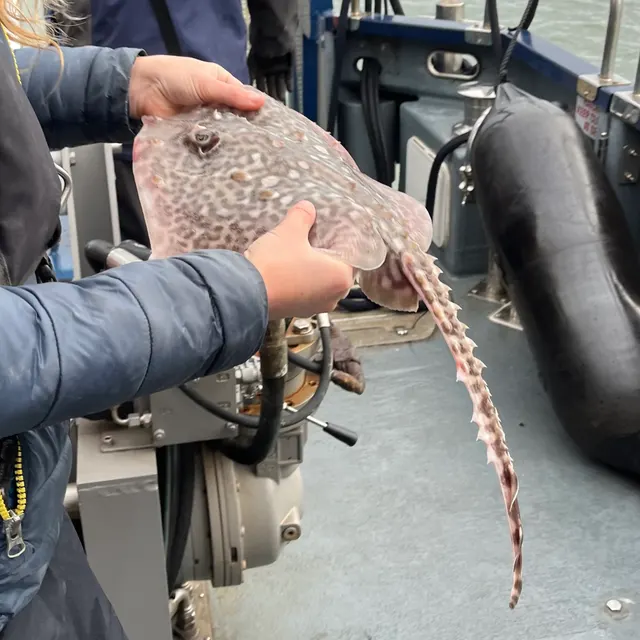 Thornback rayRegular local target3 placesLoch Linnhe, Loch Etive, GairlochOver sea loch
 European flounderRegular local target2 placesDurness and Balnakeil Bay, Loch LinnheOver bay, sea loch
 Atlantic codRegular local target1 placeGairlochOver sea loch
Also documented from the shore: Small-spotted catshark · Spurdog · European sea bass · Atlantic mackerel · Saithe · Haddock
From a boat · 10
- Thornback rayRegular local target2 places · 1 fishery account · 1 sourceOban Bay and the Sound of Kerrera, Loch Leven at BallachulishOver sea loch, sound or straitAround Apr
- Conger eelRegular local target1 placeLoch SunartOver sea loch
- Small-spotted catsharkRegular local target1 placeOban Bay and the Sound of KerreraOver sound or strait
 WhitingSeasonal4 placesLoch Broom and Ullapool, Loch Inchard and Kinlochbervie, Lochinver and Loch Inver, Loch EtiveOver sea lochAround Jun–Sept
- DabSeasonal3 placesLoch Broom and Ullapool, Loch Inchard and Kinlochbervie, Lochinver and Loch InverOver sea lochAround Jun–Sept
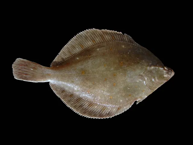 European plaiceSeasonal3 placesLoch Broom and Ullapool, Loch Inchard and Kinlochbervie, Lochinver and Loch InverOver sea lochAround Jun–Sept
Also documented from a boat: Haddock · Saithe · Grey gurnard · Pouting
From a kayak · 4
- PollackSeasonal2 places · 2 fishery accounts · 2 independent sourcesLoch Etive, Loch Leven at BallachulishOver sea lochSources name Drift fishing with Metal jigsAround Jan–Mar, May, DecObserved May 2023
- Atlantic codRepeatedly reported1 place · 1 fishery account · 1 sourceLoch Leven at BallachulishOver sea lochSources name Drift fishing with Metal jigsAround MayObserved May 2023
 Atlantic mackerelRepeatedly reported1 place · 1 fishery account · 1 sourceLoch EtiveOver sea lochSources name Kayak fishingAround AugObserved August 2023
- SpurdogRepeatedly reported1 place · 1 fishery account · 1 sourceLoch EtiveOver sea lochSources name Kayak fishingAround AugObserved August 2023
What these strengths mean
- Regular local target
- Fishing sources describe this as a normal local target here, not merely as caught.
- Seasonal
- Well supported, and concentrated in part of the year rather than spread through it.
- Repeatedly reported
- Several independent public accounts. Enough to say it happens more than once; not enough to call it a fishery.
- Recorded here
- At least one credible public account of this species being caught here. That is all it means.
- How breadth is counted
- A fish documented at six marks is shown as six marks: breadth never raises the strength on its own. A fishery account describes the fishing; a recorded catch reports one specific catch. How evidence is weighed.
How people fish here
6 methods are recorded on the places documented here, counted from the records themselves rather than from what is practised in the country. Each opens a full guide to the technique.
Spinning
Recorded at 22 places here, over sea loch, bay, headland, sound or strait.
Casting an artificial lure and retrieving it so that it moves like something alive — the most direct form of lure fishing.
Documented on the same ground: Atlantic cod, Ballan wrasse, Conger eel, European flounder, Pollack, Small-spotted catshark.
Float fishing
Recorded at 20 places here, over sea loch, bay, headland, sound or strait.
Suspending a bait at a controlled depth beneath a buoyant indicator — the most visual, most controllable and most widely applicable method in angling.
Documented on the same ground: Atlantic cod, Ballan wrasse, Conger eel, European flounder, Pollack, Small-spotted catshark.
Kayak fishing
Recorded at 20 places here, over sea loch, bay, sound or strait, tidal race.
A platform rather than a technique: quiet, shallow-draught access to water no other craft reaches, bought at the price of exposure, and a discipline where the decision not to launch is part of the skill.
Documented on the same ground: Atlantic cod, Ballan wrasse, Conger eel, European flounder, Pollack, Small-spotted catshark.
Jigging
Recorded at 17 places here, over sea loch, sound or strait, tidal race.
Working a weighted lure with a rising-and-falling motion, usually vertically, so it behaves like a wounded or fleeing baitfish.
Documented on the same ground: Atlantic cod, Ballan wrasse, Conger eel, European flounder, Pollack, Small-spotted catshark.
Ledgering
Recorded at 7 places here, over sea loch, bay, headland.
Fishing a bait on the bottom held by a weight, with no float — the simplest way to fish at distance, in depth, or in wind.
Documented on the same ground: Ballan wrasse, Conger eel, European flounder, Pollack, Atlantic mackerel, Dab.
Light rock fishing
Recorded at 1 place here, over headland.
Ultralight lure fishing from the shore with tackle rated in single grams — a discipline that catches the fish everybody else steps over, and one FishingHQ held every component of and had never named.
Documented on the same ground: Ballan wrasse, Conger eel, Atlantic mackerel, Pollack, Saithe.
These are the methods documented at the places FishingHQ holds here. A species listed beside a method is documented on the same ground, which is not the same as being taken that way — where a source establishes the method a fish was caught on, it is stated on that place’s own page. All fishing methods.
The fishing year here
The months the records under this area actually name, tightest season first. This is “observed in these months” rather than a season: a species whose months nobody recorded is not listed, because a gap in the evidence is not a year-round fishery.
- Thornback rayApril to April
- Atlantic codMay to May
- WhitingJune to September
- Ballan wrasseJune to September
- DabJune to September
- European plaiceJune to September
- HaddockJune to September
- European sea bassJune to September
- SpurdogJune to September
- Atlantic mackerelJune to September
- SaitheApril, June, July, August and September
- PollackJanuary, February, March, May, June, July, August, September, October and December
What dominates
Small-boat and charter fishing over the deep basins, which is the characteristic practice and includes a specialist deep-water fishery. Kayak fishing, which the geometry suits: a sill and narrow entrance dissipate Atlantic swell, so the water inside is workable when the open coast is not, and depth lies close to the launch point. Shore fishing from steep rock and pier for pollack, coalfish, wrasse and conger. Lure and fly fishing along the kelp margins and at the narrows. Sea trout fishing in the brackish head and around river mouths. Some diving and spearfishing where permitted and where visibility allows. Static gear and creeling are commercially significant in many lochs, which matters to anglers as a source of gear conflict rather than as a method.
The water available
Deep glacial basins, sometimes deeper than the sea outside; shallow sills across the mouth; tidal narrows with strong streams and standing waves; steep rock and kelp sides with deep water close inshore; soft mud and maerl beds on the basin floor; brackish, river-fed heads with a salinity gradient; and shallow bays and sheltered anchorages along the length.
How the rules are structured
Sea angling in Scotland is not licensed, but conservation measures apply and some are specific to this system: common skate is a prohibited species that must be returned and is subject to a research and tagging programme, and several sea lochs carry marine protected area designations made partly for that species and for the maerl and flame shell beds on their floors. Those designations can restrict activities including anchoring and certain gear. Salmon and sea trout in the rivers entering the lochs are separately governed, with district salmon fishery boards and river-specific rules including mandatory catch-and-release on many systems. Shellfish gathering is governed by harvest area classification and biotoxin monitoring. Many lochs carry aquaculture, and access and navigation around it is a local matter. FishingHQ does not state what any current rule is.
Who to ask
- Marine Directorate of the Scottish Government, for sea fisheries measures and for marine protected area management.
- NatureScot, for designated site management where a designation affects activity in a loch.
- The relevant District Salmon Fishery Board or Fishery Trust, for salmon and sea trout in the rivers entering the loch.
- Food Standards Scotland and the relevant classification and monitoring programme, for shellfish harvest area classification and biotoxin status.
- The harbour authority or local moorings body where launching and berthing are involved.
- The Maritime and Coastguard Agency and the RNLI, for safety guidance on these waters.
Words you will meet
- Sill
- The shallow bar of rock or moraine across a loch's mouth, left where the glacier ended. It partially isolates the deep basin behind it from the open sea, which is why the basin's water has its own temperature and oxygen history.
- Narrows
- A constriction along the loch where the whole tidal exchange is forced through a small cross-section. Streams there are fast, standing waves and overfalls form on spring tides, and food and predators concentrate — excellent fishing and genuinely hazardous for small craft.
- Basin
- The deep central section of the loch behind the sill, frequently deeper than the sea outside. It holds the deep-water species and is where the specialist boat fishery operates.
- Head
- The inner end of the loch, where the river enters. Brackish, silty, shallower, and a quite different fishery — sea trout, mullet and flounder rather than skate and spurdog.
Conditions and hazards
Sea lochs are the sheltered water of an exposed coast and that is exactly what makes their hazards easy to underestimate. Shelter from swell is real, and it does not extend to wind: a long loch aligned with the wind produces a substantial fetch and a steep short sea, and katabatic wind falling off steep sides can arrive suddenly and strongly in otherwise settled weather. The narrows are the specific hazard — spring tidal streams there run hard, produce overfalls and standing waves, and are capable of holding a kayak or small boat that cannot make headway against them; the transition between workable and unmanageable happens within a tide rather than gradually. Water is cold year-round and the sides are steep, so somebody in the water may have a long way to go to a landing place. Many lochs are remote with poor mobile coverage. Aquaculture structures, moorings and static gear are widespread and are both an entanglement hazard and a navigation one, particularly at night. A buoyancy aid, planning passage through narrows around slack water, checking the wind against the loch's alignment rather than the general forecast, and telling somebody the plan are the measures that address the actual mechanisms.
What the sill does, and why it makes the loch a different sea
Almost everything distinctive about a sea loch comes from the sill, and the mechanism is worth following properly because it explains features that otherwise look arbitrary.
A GLACIER CUTS DEEPEST WHERE IT IS THICKEST. Confined in a valley, ice is deep and erosive; where it spreads at its terminus it thins and erodes less. So the valley it leaves is deep along its length and shallow at the seaward end — and when the sea floods it, that shallow end becomes a sill across the mouth.
THE SILL RESTRICTS DEEP EXCHANGE. Surface water passes over it freely with every tide, but water in the basin below sill depth cannot simply flow out, because there is a wall of rock in the way. It is replaced only when water outside becomes dense enough to sink over the sill and displace it — which depends on temperature and salinity outside rather than on the tide.
SO BASIN WATER HAS ITS OWN HISTORY. Between renewal events it sits. Organic material sinks into it and decomposes, consuming oxygen that is not being replaced. In lochs with a shallow sill and a deep basin, that can produce genuinely low-oxygen deep water, and where it does the fish community at depth is limited by oxygen rather than by anything else.
FRESH WATER ADDS THE SECOND LAYER. River input at the head is buoyant, so it flows seaward across the surface while denser sea water moves landward underneath. This estuarine circulation runs continuously, produces a salinity gradient from head to mouth, and means the surface and the depth are moving in opposite directions.
THE PRACTICAL CONSEQUENCES ARE SPECIFIC. Fish distribute by depth far more sharply than on the open coast. The sill and narrows concentrate food and predators because the whole exchange squeezes through them. The head is a brackish fishery and the basin is a deep marine one, in the same loch, an hour apart. And a loch's character depends on its own sill depth and freshwater input, which is why two adjacent lochs can behave quite differently — a fact that looks like local mystique and is actually geometry.
Backed by research — why, and the sources (4)
Supported by peer-reviewed research or fisheries science. The sources are listed and can be checked.
- Cefas science, advice and data on marine and freshwater environments — Centre for Environment, Fisheries and Aquaculture Science (Government fisheries body)Relied on for: Marine environmental science for UK shelf seas, including the physical characterisation of sediment, coastal process and the monitoring programmes that describe them.States this directlyCitation checked — the work exists and is described correctly
- ICES Advice on fishing opportunities, catch and effort — International Council for the Exploration of the Sea (Scientific institute)Relied on for: Ecoregion description, stock distribution and the hydrography of the sea areas assessed.States this directlyCitation checked — the work exists and is described correctly
- ICES Advice on fishing opportunities, catch and effort — International Council for the Exploration of the Sea (Scientific institute)Relied on for: Stock distribution, ecoregion boundaries and the physical description of the sea areas assessed, including depth, salinity and hydrography.States this directlyCitation checked — the work exists and is described correctly
- FishBase: a global information system on fishes — Froese, R. and D. Pauly, eds. — FishBase Consortium (Scientific institute)Relied on for: Distribution, temperature tolerance and habitat association of the species named as characteristic of these waters.States this directlyPassage read and verified
Common skate: a fishery that is a conservation programme
The species most associated with Scottish sea lochs is a critically endangered one, and the way it is fished is unusual enough to be worth setting out.
THE FISH IS THE LARGEST SKATE IN EUROPEAN WATERS and was formerly widespread across the north-east Atlantic. It was reduced across most of that range by trawling, because a large, slow-growing, late-maturing elasmobranch that lays a small number of eggs cannot absorb sustained bycatch. It disappeared from large parts of its former range entirely.
SOME WEST COAST SEA LOCHS RETAINED POPULATIONS, in deep basins where trawling was impractical. Those populations are now among the most important remaining anywhere.
THE ANGLING FISHERY IS STRICTLY CATCH AND RELEASE and is embedded in research. Fish are tagged, recorded and returned, and the resulting recapture data is a substantial part of what is known about the species' movement, growth and site fidelity. Anglers and skippers are the people generating that data.
THE HANDLING REQUIREMENTS ARE REAL AND NOT OPTIONAL. A fish of this size must not be lifted vertically or hung by the wings — the body mass is unsupported and internal damage follows. It is unhooked in the water or brought aboard flat and supported, kept wet, handled minimally and returned promptly. Skippers who run this fishery have established protocols and a visiting angler should expect to follow them rather than improvise.
AND THE SPECIES IS PROTECTED. It is a prohibited species that must be returned, and several of the lochs holding it carry protected area designations made partly for it. The current legal position and the current handling requirements are matters for the responsible authority and for the skipper, and this page does not restate them because they change and because getting them wrong here has consequences for a species that has already lost most of its range.
Official guidance — why, and the sources (2)
Stated by a fisheries authority, scientific institute or recognised angling body. Authoritative, but summarising rather than demonstrating.
- FishBase: a global information system on fishes — Froese, R. and D. Pauly, eds. — FishBase Consortium (Scientific institute)Relied on for: Distribution, habitat association and thermal tolerance of the species named as characteristic of these waters.States this directlyPassage read and verified
- JNCC species and habitat conservation advice — Joint Nature Conservation Committee (Conservation authority)Relied on for: Designation, habitat description and conservation status of the marine and coastal habitats named.States this directlyCitation checked — the work exists and is described correctly
Shelter, narrows and why this is the kayak water of the west
Sea lochs are the reason small-craft fishing is possible on a coast that is otherwise among the most exposed in Europe, and understanding the limits of that shelter is the useful part.
THE SWELL DOES NOT GET IN. A sill and a narrow entrance dissipate Atlantic swell very effectively, so the water inside a loch can be workable when the coast outside is not fishable at all. For kayak and small-boat anglers this is the difference between a season and a handful of days.
THE WIND DOES GET IN. A loch aligned with the wind gives it a clean fetch down its whole length, and the resulting short steep sea builds quickly. Steep sides also produce katabatic gusts — cold air falling off high ground — that arrive suddenly and much stronger than the general forecast, particularly in settled cold weather. Shelter from swell is not shelter from wind and the two are frequently confused.
THE NARROWS ARE THE REAL HAZARD. The entire tidal exchange of a large loch passes through a small cross-section, and on spring tides that produces streams a paddler cannot make headway against, along with overfalls and standing waves. Passage through narrows is planned around slack water, and a craft that arrives late is not merely slowed — it may be unable to progress at all and unable to turn back safely.
DEEP WATER IS CLOSE TO THE LAUNCH. That is the fishing advantage: a kayak can be over sixty metres of water within a few hundred metres of a slipway, which on most coasts requires a long committing paddle. It also means a capsize happens over deep cold water rather than a shallow bottom.
AND THE STRUCTURE IS BUSY. Fish farms, moorings, creel lines and buoys are widespread. They hold fish and they are an entanglement and navigation hazard, and creel lines in particular are both a snag risk and somebody's working gear. Passing wide of them is both safety and courtesy.
The honest summary is that sea lochs make small-craft fishing possible on this coast and do not make it easy. Not launching remains a legitimate answer, and on a spring tide with wind down the loch it is frequently the right one.
Official guidance — why, and the sources (4)
Stated by a fisheries authority, scientific institute or recognised angling body. Authoritative, but summarising rather than demonstrating.
- RNLI water safety guidance: cold water shock and Float to Live — Royal National Lifeboat Institution (Water-safety or diver-training authority)Relied on for: Cold water shock and the immersion response, tidal cut-off, and water-safety guidance for shore anglers and small-craft users.States this directlyPassage read and verified
- Met Office shipping forecast, inshore waters forecast and marine warnings — Met Office, United Kingdom (Government fisheries body)Relied on for: That inshore waters forecasts, sea state and swell are the operative inputs for shore and small-craft decisions in these waters.States this directlyCitation checked — the work exists and is described correctly
- Fishers' Craft and Lettered Art: Tracts on Fishing from the End of the Middle Ages — University of Toronto Press, 1997 (Scientific literature)Relied on for: That fishing traditions develop around the water and fish available to them, and the historical method of reading such traditions.States this directlyCitation checked — the work exists and is described correctly
- General angling website restatements of established technique — Various (Credible secondary source)Relied on for: Widely restated descriptions of regional angling practice, recorded as practitioner consensus rather than as scholarship.Background and mechanism onlyCitation checked — the work exists and is described correctly
The forecast is for the wrong place, and the loch makes its own weather
The hazard that catches people on a sea loch is not a hazard they were warned about, because the warning was issued for somewhere else.
AN INSHORE WATERS FORECAST DESCRIBES A SEA AREA TENS OF KILOMETRES ACROSS. A sea loch is a steep-sided trench a few hundred metres wide with mountains on both sides, and it does not experience that forecast. Air draining off high ground accelerates downhill and arrives on the water as a squall from a direction the synoptic chart does not predict, at a strength it does not predict either, with no change in the general weather to announce it. A morning that was flat calm at launch can be unworkable within the hour while the forecast for the sea area outside remains accurate and unchanged.
THE SECOND MECHANISM IS THE NARROWS. Sea lochs are frequently constricted at the mouth or partway up by a sill or a strait, and the whole tidal exchange of the basin above passes through that gap. The result is a genuine tidal stream in a place that looks enclosed and sheltered, and wind blowing against that stream builds a short steep sea very quickly in water that was smooth twenty minutes earlier.
THESE TWO COMBINE BADLY AND SPECIFICALLY. A squall from the hill, meeting an ebb through a narrows, on a small boat or a kayak, in water that is cold all year. That is not three hazards in a list; it is one sequence, and it is the sequence that kills people here.
COLD IS THE CONSTANT UNDERNEATH ALL OF IT. Immersion in Scottish sea water produces an involuntary gasp and loss of breathing control within seconds in any month. The season does not make this water survivable; it only changes how long afterwards matters.
REMOTENESS CHANGES THE ARITHMETIC RATHER THAN THE RISK. Much of this coast has no mobile coverage, roads that follow the loch rather than cross it, and long distances to help. An incident that would be recoverable elsewhere is not necessarily recoverable here, which is an argument for not having it rather than for responding to it well.
AND THERE IS FIXED GEAR IN THE WATER. Aquaculture is extensive on this coast, and moorings, nets and lines are a real entanglement hazard for a small craft and a serious one for anybody in the water.
WHAT ACTUALLY HELPS is treating the loch's own wind as the forecast rather than the sea area's, fixing a turnaround time and an escape shore before launching, wearing a buoyancy aid rather than carrying one, carrying a means of calling for help on the person, and telling somebody ashore the plan and the return time. Check the current inshore waters forecast and the tide before going afloat, and treat any increase in wind as the beginning of a trend.
Official guidance — why, and the sources (2)
Stated by a fisheries authority, scientific institute or recognised angling body. Authoritative, but summarising rather than demonstrating.
- Met Office shipping forecast, inshore waters forecast and marine warnings — Met Office, United Kingdom (Government fisheries body)Relied on for: That inshore waters forecasts, sea state, swell and wind are the operative inputs for shore and small-craft decisions, and the spatial resolution at which those forecasts are issued.States this directlyCitation checked — the work exists and is described correctly
- RNLI water safety guidance: cold water shock and Float to Live — Royal National Lifeboat Institution (Water-safety or diver-training authority)Relied on for: Cold water shock and the immersion response, tidal cut-off, and water-safety guidance for shore anglers and small-craft users.States this directlyPassage read and verified
Some of what lives here
Fish recorded here that FishingHQ holds a reviewed photograph of. It is not a complete list of what Scottish sea lochs holds, and it is not a prediction that you will catch any of them — it is a way in to the ones we can show you.
- PollackA fast gadoid that hunts up off reefs and wrecks and takes a lure on the drop — and the sea fish most likely to convert a bait angler to lure fishing.
Wilhelm Thomas Fiege — CC BY-SA 4.0, via Wikimedia Commons
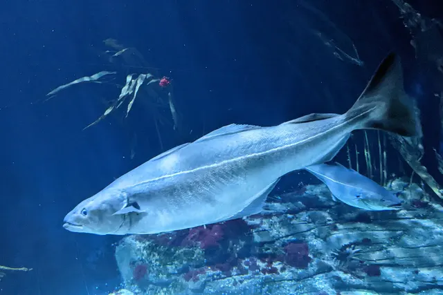 SaitheA fast, hard-fighting shoaling gadoid of northern rock and wreck — routinely confused with pollack, and a completely different fish once you know the lateral line.
Wilhelm Thomas Fiege — CC BY-SA 4.0, via Wikimedia Commons
- Conger eelA very large scaleless eel of wrecks, rock and harbour walls, reaching three metres, and among the most powerful and most genuinely dangerous fish to handle in European seas.
Holger Krisp — CC BY 3.0, via Wikimedia Commons
- WhitingA small, abundant, silver gadoid of European coasts, a mainstay of winter shore fishing and distinguished by a dark spot at the pectoral fin base.
rmjb — CC BY, via iNaturalist
- European flounderThe flatfish that runs up rivers — a tolerant, estuarine right-eyed flounder with bony tubercles along its fin bases and a habit of turning up in fresh water.
nbasargin — CC BY, via iNaturalist
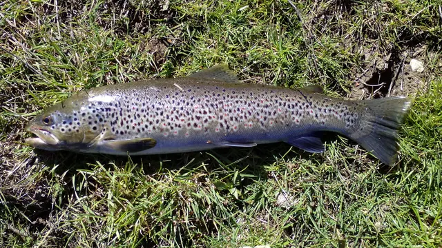 Brown troutA single, extraordinarily plastic species that appears as a tiny hill-stream fish, a deep-bodied loch trout and a silver sea-run migrant — all the same animal.
Robermix, CC0, via Wikimedia Commons
- Ballan wrasseA long-lived rocky-ground resident that begins life female and may change sex — and the species that turned rock marks into a lure fishery.
Diego Delso — CC BY-SA 4.0, via Wikimedia Commons
Places within this area
Publicly documented fishing geography. FishingHQ describes what the ground is; it does not say whether you may fish it, and every one of these sends that question to the body that holds the answer. Browse every place in this part of the world.
Who to ask before fishing any of these
FishingHQ does not know the current access position here. Sea angling in Scotland is not rod-licensed, but access rights under the Scottish Outdoor Access Code carry responsibilities, and harbour, local authority, marine conservation and fisheries measures all apply and all change. Check the current position with the Marine Directorate, the harbour or local authority and the land manager before going.
FishingHQ does not know the current access position here. Sea angling in Scotland is not rod-licensed, but access rights under the Scottish Outdoor Access Code carry responsibilities, and harbour, local authority, marine conservation and fisheries measures all apply and all change. Check the current position with the Marine Directorate, the harbour or local authority and the land manager before going. This water is tidal and transitional, so the freshwater regime may also apply above the tidal limit: FishingHQ does not know the current access position here. Scotland has no general rod licence, and the fishing rights on almost every river and loch belong to somebody: a proprietor, an estate, an angling association or a district salmon fishery board. Permission is a separate question from access, and both change. Check with the relevant fishery board or association before going.
Loch Broom and Ullapool
Sea loch · Salt water
A long, deep, steep-sided fjordic sea loch running south-east into Wester Ross from the Minch, with rock walls, deep basins, a fishing port halfway along it and the Summer Isles archipelago across its mouth.
The loch itself is sheltered from swell by its own walls and by the islands outside; the mouth and the Minch beyond are fully exposed. Katabatic and funnelled winds off the surrounding hills are the real weather hazard here rather than the synoptic forecast.
Particular to this ground: cold water shock, weather and lightning.
Severe hazards of Scottish sea lochs apply here: moving water and currents, boat safety, fish welfare.
Particular to this water: Shellfish harvesting areas are classified for food safety and are opened and closed on monitoring results a gatherer cannot see. Neither cooking nor appearance removes a biotoxin. Check the current classification with the local authority before taking anything.
Loch Etive
Sea loch · Brackish water
A thirty-kilometre fjordic sea loch behind a shallow rock sill at Connel, where the Falls of Lora form. Deep anoxic basins inside, a rapid at the mouth, and steep mountain sides throughout.
Almost completely sheltered from swell. Wind funnelling down the glen is the operative weather.
Particular to this ground: moving water and currents, cold water shock.
Severe hazards of Scottish sea lochs apply here: boat safety, fish welfare.
Durness and Balnakeil Bay
Bay · Salt water
A limestone-floored bay of white shell sand at the north-western corner of the mainland, backed by machair, with hard quartzite reef at Faraid Head and exceptionally clear water.
Severe hazards of Scottish sea lochs apply here: moving water and currents, boat safety, cold water shock, fish welfare.
Loch Inchard and Kinlochbervie
Sea loch · Salt water
A short, deep, steep-sided sea loch in Lewisian gneiss with a working fishing harbour partway along it, deep water close to the rock and heavy kelp on the margins.
Severe hazards of Scottish sea lochs apply here: moving water and currents, boat safety, cold water shock, fish welfare.
Loch Laxford
Sea loch · Salt water
A sea loch set in a landscape of bare Lewisian gneiss knock-and-lochan, with dozens of islands and skerries, deep basins between them and very little soft sediment anywhere.
Severe hazards of Scottish sea lochs apply here: moving water and currents, boat safety, cold water shock, fish welfare.
Lochinver and Loch Inver
Sea loch · Salt water
A short sea loch with a major working fishing harbour at its head, beneath Suilven and Canisp, with deep water, rock walls and a shelving gravel shore at the river mouth.
Severe hazards of Scottish sea lochs apply here: moving water and currents, boat safety, cold water shock, fish welfare.
Gruinard Bay
Bay · Salt water
A red sandstone bay of pink shell sand and rock between two headlands in Wester Ross, with an island in its mouth and clean shallow water over sand between the reefs.
Severe hazards of Scottish sea lochs apply here: moving water and currents, boat safety, cold water shock, fish welfare.
Loch Ewe
Sea loch · Salt water
A north-facing sea loch open to the Minch with an island in its middle, deep basins, and a wartime anchorage history that left extensive structures on its shores.
Severe hazards of Scottish sea lochs apply here: moving water and currents, boat safety, cold water shock, fish welfare.
14 more places in this area
Gairloch
Sea loch · Salt water
A wide, comparatively shallow west-facing sea loch with sand bays along its southern shore, rock and kelp on the north, and deeper water out towards the Minch.
Severe hazards of Scottish sea lochs apply here: moving water and currents, boat safety, cold water shock, fish welfare.
Loch Torridon
Sea loch · Salt water
A deep fjordic loch beneath Torridonian sandstone mountains, with an inner loch behind a shallow narrows, a nationally important prawn ground and very deep water in the outer basin.
Severe hazards of Scottish sea lochs apply here: moving water and currents, boat safety, cold water shock, fish welfare.
Applecross and the Inner Sound
Sound or strait · Salt water
The deepest inshore water in British seas — over three hundred metres in the Inner Sound trench — lying between the mainland and Raasay, with a shelving rock and shingle shore at Applecross.
Severe hazards of Scottish sea lochs apply here: moving water and currents, boat safety, cold water shock, fish welfare.
Loch Carron and Plockton
Sea loch · Salt water
A sea loch with a shallow rock narrows at Stromeferry dividing a deep outer basin from a quieter inner one, with flame shell beds on the sill and sheltered anchorages at Plockton.
Severe hazards of Scottish sea lochs apply here: moving water and currents, boat safety, cold water shock, fish welfare.
Loch Duich
Sea loch · Salt water
A steep-sided fjordic loch beneath the Five Sisters of Kintail, joining Loch Alsh through a narrows at Eilean Donan, with deep water and a strong freshwater input at its head.
Severe hazards of Scottish sea lochs apply here: moving water and currents, boat safety, cold water shock, fish welfare.
Loch Hourn
Sea loch · Salt water
One of the most fjord-like lochs in Britain: a long, narrow, extremely steep-sided inlet with a shallow sill at Caolas Mor and deep, poorly-flushed basins behind it.
Severe hazards of Scottish sea lochs apply here: moving water and currents, boat safety, cold water shock, fish welfare.
Loch Nevis and Mallaig
Sea loch · Salt water
A deep fjordic loch with a working ferry and fishing port at its mouth, an inner basin behind a shallow narrows at Kylesknoydart, and no road to most of its shore.
Severe hazards of Scottish sea lochs apply here: moving water and currents, boat safety, cold water shock, fish welfare.
Loch Sunart
Sea loch · Salt water
The longest sea loch in the western Highlands, running thirty kilometres inland with a series of sills and basins, ancient oakwood along its shores and a rich sublittoral reef community.
Severe hazards of Scottish sea lochs apply here: moving water and currents, boat safety, cold water shock, fish welfare.
Ardnamurchan Point
Headland · Salt water
The most westerly point of the British mainland: a hard igneous headland of a ring-dyke volcanic complex, with deep water immediately offshore and full exposure to the Atlantic.
Severe hazards of Scottish sea lochs apply here: moving water and currents, boat safety, cold water shock, fish welfare.
Loch Linnhe
Sea loch · Salt water
A long fault-guided sea loch running along the Great Glen, deep and steep-sided, with the Corran narrows partway along it constricting the whole tidal exchange of the upper loch.
Severe hazards of Scottish sea lochs apply here: moving water and currents, boat safety, cold water shock, fish welfare.
Oban Bay and the Sound of Kerrera
Sound or strait · Salt water
A sheltered bay behind the island of Kerrera with a busy ferry port, deep water in the sound, and rock and kelp shores giving way to mud in the bay itself.
Severe hazards of Scottish sea lochs apply here: moving water and currents, boat safety, cold water shock, fish welfare.
Loch Craignish and the Dorus Mor
Tidal race · Salt water
A narrow island-studded loch opening into the Dorus Mor — the 'great door' — where the tidal stream between Craignish Point and Garbh Reisa runs at up to eight knots.
Particular to this ground: moving water and currents.
Severe hazards of Scottish sea lochs apply here: boat safety, cold water shock, fish welfare.
Rhue Point
Headland · Salt water
The low lighthouse point at the mouth of Loch Broom, with rock slabs and kelp gullies running off it and the loch's deep water close by. The turn where the loch meets the Minch, which is what concentrates the fish.
Open north-west into the Minch; the loch behind it is sheltered.
Particular to this ground: cliffs and rock platforms, cold water shock.
Severe hazards of Scottish sea lochs apply here: moving water and currents, boat safety, fish welfare.
Loch Leven at Ballachulish
Sea loch · Salt water
A short sea loch entered through narrows at Ballachulish, with deep reefy ground in the upper basin above the narrows and a working fish farm in the lower one. Smaller and shallower than the fjordic lochs either side of it.
Severe hazards of Scottish sea lochs apply here: moving water and currents, boat safety, cold water shock, fish welfare.
Particular to this water: The diary this record rests on launches a small boat from the slate slip at Ballachulish. A slipway existing is not a slipway anybody may use, and whether launching, parking or fishing is permitted here is a question for the harbour authority, the landowner and the local authority rather than for this page.
Why the deep water in a sea loch is at the far end from the sea
Why the deep water in a sea loch is at the far end from the sea
Reading the ground · Draft — not yet checked against an external reference
This drawing has not been checked against any reference outside FishingHQ. It is a schematic of what the surrounding text describes, and the text is what carries the detail.
Describe this diagram in words
A cross-section along the length of a Scottish fjordic sea loch, from the open sea at the left to the head of the loch at the right. At the left the sea bed shelves gently upward towards the mouth. At the mouth it rises into a bar of rock — the sill — which is the shallowest point the bottom reaches anywhere in the figure, with an arrow above it pointing inward to show the tidal stream that has to squeeze across it and a label naming the rapid that forms there as a result. Landward of the sill the bottom falls away steeply into a broad, flat-floored basin lying far below the level of the bar and below the sea bed outside, so that the water gets deeper the further from the sea you go rather than shallower. A second line beneath the surface across the inner loch marks the base of a fresher layer floating on the denser sea water below; it sits shallower than the crest of the sill, which is why the bar holds the loch's water in. At the head an arrow points down into the loch to show the river or burn that supplies the fresh layer. No depth, distance, gradient or stream rate appears anywhere on the figure, and no loch is named: this is the shape the west-coast lochs share rather than a map of any one of them.
How this drawing was produced
Drawn by hand, and then looked at as a finished image before publication — which is not the same check as verifying its coordinates, and here it caught three things the coordinates could not. A NEAR BANK was drawn rising out of the basin, to show how close deep water is to a road. It was a second viewpoint inside a single side-on section, and on the page it read as the bottom crossing itself. Removed; its point moved into the text. THE TIDAL ARROW had no head. A plain horizontal stroke sat beneath the label for the sill and read as a rule underlining it rather than as water moving. It now carries a chevron. THE FRESHER LAYER sat at the height of the crest of the sill and the two lines collided. It is now clearly shallower than the crest, which is true and is why the sill matters. The vertical is exaggerated, as on every section drawn through a piece of sea floor.
Safety
Moving water and currents — Can cause serious injury or death
The whole tidal exchange of a loch is forced through its narrows, producing fast streams, overfalls and standing waves on spring tides. A kayak or small boat can be unable to make headway against them and unable to turn back safely, and the change from workable to unmanageable happens within a tide rather than gradually.
What reduces it: Plan passage through narrows around slack water and know the times before launching. Treat arriving late at a narrows as a reason to wait for the next slack rather than to attempt it. Carry the means to get off the water without an engine.
Worse when:
- Spring tides, when the streams are strongest.
- Wind opposing the stream, which stands the water up in the narrows.
Boat safety — Can cause serious injury or death
Shelter from Atlantic swell is not shelter from wind. A loch aligned with the wind gives it a clean fetch and builds a short steep sea quickly, and katabatic gusts falling off steep sides arrive suddenly and much stronger than the general forecast suggests.
What reduces it: Check the wind direction against the loch's alignment rather than reading the regional forecast alone. Plan a route home that does not require a long upwind leg, set a turn-back point before launching, and wear a buoyancy aid. Deciding not to launch is a legitimate answer.
Cold water shock — Can cause serious injury or death
Water is cold year-round and the sides of a loch are steep, so somebody in the water may be a long way from any landing place, over deep water, close to the shore but unable to get out of it.
What reduces it: A buoyancy aid worn, not carried. Know where the landable shore is along the route rather than assuming the nearest bank will do, and treat proximity to land as unrelated to ability to get out.
Fish welfare — Can cause serious injury or death
Common skate is critically endangered and survives in numbers in some of these lochs. A large skate lifted vertically or hung by the wings suffers internal damage from unsupported body mass, and a fish handled badly is a meaningful loss to a population that has already lost most of its range.
What reduces it: Unhook in the water where possible, or bring the fish aboard flat and supported. Keep it wet, handle it minimally, never hang it by the wings or lift it vertically, and return it promptly. Follow the skipper's protocol rather than improvising, and follow the responsible authority's current requirements for a prohibited species.
Entanglement — Can cause injury needing treatment
Fish farm structures, moorings, marker buoys and creel lines are widespread in many lochs. They are a snag and entanglement hazard for anglers and small craft, particularly in poor light, and they are somebody's working gear.
What reduces it: Pass wide of aquaculture structures and creel lines, carry a knife accessible on the person in a small craft, and avoid drifting onto marked gear. Do not attempt to free tackle from working gear by pulling on it.
Precautions that always apply here
- Wear a buoyancy aid or lifejacket. Cold water incapacitates strong swimmers within a minute, long before swimming ability matters.
- Tell somebody where you are going and when you expect to be back.
- Carry a charged phone in a waterproof case, or another means of calling for help.
- Support the fish's weight along its body, keep it out of the water for as short a time as possible, and hold it over something soft.
- Check the tide before you go and know your exit route. Being cut off is the commonest way a shore session becomes a rescue.
Further safety reading
- Cold water shock and immersion — Water is cold year-round and loch sides are steep, so somebody in the water may be close to land and a long way from anywhere they can get out of it. Proximity to the shore is unrelated to the ability to leave the water.
- Kayak fishing: cold water, offshore wind and getting back on — Sea lochs are the sheltered water of an exposed coast, and shelter from swell is not shelter from wind: a loch aligned with the wind gives it a clean fetch, and katabatic gusts fall off steep sides suddenly and much stronger than the general forecast. The narrows are the specific hazard, where spring streams can hold a craft that cannot make headway.
Check the rules before you fish
Fishing laws, bylaws, access rules, seasons, bait restrictions and permitted methods vary by location and can change. Check the current rules from the relevant authority and the water you intend to fish before fishing.
Check with:
- Current national or regional law for where you are fishing
- Current local bylaws
- The relevant fisheries authority
- The landowner, club or fishery whose water it is
- Any restrictions specific to the species or the method you intend to use
Where to go next
What swims here
- Ballan wrasseResident in the kelp and boulder margins along loch sides, in water sheltered enough for it to be reachable when the open coast is not fishable at all.
- Brown troutThe sea-run form uses the brackish heads of these lochs and the rivers entering them, and the two-layer circulation that carries fresh water seaward across the surface is the gradient it moves through.
- Conger eelOccupies the broken rock, pier structure and deep basin floor of these systems.
- European flounderOccupies the brackish, silty head of a loch where the river enters, tolerating the salinity gradient that runs from nearly fresh at the head to fully marine at the mouth.
- PollackAssociated with the kelp margins and steep rock sides of a loch, where deep water lies within a few metres of the shore — which is why a kayak can reach serious depth a short paddle from a slipway here.
- SaitheAbundant along loch sides, around piers and at the narrows, and the species most likely to be caught by anybody fishing a sea loch for the first time.
- WhitingA deep-basin species here, occupying the water behind the sill that the shallow entrance partially isolates from the open sea.
Local knowledge
How this compares
Environment and conservation
Sources and evidence
- Cefas science, advice and data on marine and freshwater environments — Centre for Environment, Fisheries and Aquaculture Science (Government fisheries body)Relied on for: Marine environmental science for UK shelf seas, including the physical characterisation of sediment, coastal process and the monitoring programmes that describe them.States this directlyCitation checked — the work exists and is described correctly
- ICES Advice on fishing opportunities, catch and effort — International Council for the Exploration of the Sea (Scientific institute)Relied on for: Ecoregion description, stock distribution and the hydrography of the sea areas assessed.States this directlyCitation checked — the work exists and is described correctly
- ICES Advice on fishing opportunities, catch and effort — International Council for the Exploration of the Sea (Scientific institute)Relied on for: Stock distribution, ecoregion boundaries and the physical description of the sea areas assessed, including depth, salinity and hydrography.States this directlyCitation checked — the work exists and is described correctly
- FishBase: a global information system on fishes — Froese, R. and D. Pauly, eds. — FishBase Consortium (Scientific institute)Relied on for: Distribution, temperature tolerance and habitat association of the species named as characteristic of these waters.States this directlyPassage read and verified
- FishBase: a global information system on fishes — Froese, R. and D. Pauly, eds. — FishBase Consortium (Scientific institute)Relied on for: Distribution, habitat association and thermal tolerance of the species named as characteristic of these waters.States this directlyPassage read and verified
- JNCC species and habitat conservation advice — Joint Nature Conservation Committee (Conservation authority)Relied on for: Designation, habitat description and conservation status of the marine and coastal habitats named.States this directlyCitation checked — the work exists and is described correctly
Why the 13 connections on this page are here, and the sources
What swims here
Backed by research — 7 connections
Supported by peer-reviewed research or fisheries science. The sources are listed and can be checked.
Ballan wrasse
A claim that a place contains the ground and conditions the species is associated with. It is a distributional statement about the world, it rests on the regional reference literature, and it deliberately asserts nothing about access, permission or catch.
- The Fishes of the British Isles and North-West Europe — Macmillan, 1969 (Reference work)Relied on for: Distribution and habitat association of the marine and estuarine fishes of the British Isles, including which coasts and ground types a species occupies.States this directlyCitation checked — the work exists and is described correctly
- FishBase: a global information system on fishes — Froese, R. and D. Pauly, eds. — FishBase Consortium (Scientific institute)Relied on for: Recorded distribution, depth range and habitat association for the species named.States this directlyPassage read and verified
Brown trout
A claim that a place contains the ground and conditions the species is associated with. It is a distributional statement about the world, it rests on the regional reference literature, and it deliberately asserts nothing about access, permission or catch.
- The Fishes of the British Isles and North-West Europe — Macmillan, 1969 (Reference work)Relied on for: Distribution and habitat association of the marine and estuarine fishes of the British Isles, including which coasts and ground types a species occupies.States this directlyCitation checked — the work exists and is described correctly
- FishBase: a global information system on fishes — Froese, R. and D. Pauly, eds. — FishBase Consortium (Scientific institute)Relied on for: Recorded distribution, depth range and habitat association for the species named.States this directlyPassage read and verified
Conger eel
A claim that a place contains the ground and conditions the species is associated with. It is a distributional statement about the world, it rests on the regional reference literature, and it deliberately asserts nothing about access, permission or catch.
- The Fishes of the British Isles and North-West Europe — Macmillan, 1969 (Reference work)Relied on for: Distribution and habitat association of the marine and estuarine fishes of the British Isles, including which coasts and ground types a species occupies.States this directlyCitation checked — the work exists and is described correctly
- FishBase: a global information system on fishes — Froese, R. and D. Pauly, eds. — FishBase Consortium (Scientific institute)Relied on for: Recorded distribution, depth range and habitat association for the species named.States this directlyPassage read and verified
European flounder
A claim that a place contains the ground and conditions the species is associated with. It is a distributional statement about the world, it rests on the regional reference literature, and it deliberately asserts nothing about access, permission or catch.
- The Fishes of the British Isles and North-West Europe — Macmillan, 1969 (Reference work)Relied on for: Distribution and habitat association of the marine and estuarine fishes of the British Isles, including which coasts and ground types a species occupies.States this directlyCitation checked — the work exists and is described correctly
- FishBase: a global information system on fishes — Froese, R. and D. Pauly, eds. — FishBase Consortium (Scientific institute)Relied on for: Recorded distribution, depth range and habitat association for the species named.States this directlyPassage read and verified
Pollack
A claim that a place contains the ground and conditions the species is associated with. It is a distributional statement about the world, it rests on the regional reference literature, and it deliberately asserts nothing about access, permission or catch.
- The Fishes of the British Isles and North-West Europe — Macmillan, 1969 (Reference work)Relied on for: Distribution and habitat association of the marine and estuarine fishes of the British Isles, including which coasts and ground types a species occupies.States this directlyCitation checked — the work exists and is described correctly
- FishBase: a global information system on fishes — Froese, R. and D. Pauly, eds. — FishBase Consortium (Scientific institute)Relied on for: Recorded distribution, depth range and habitat association for the species named.States this directlyPassage read and verified
Saithe
A claim that a place contains the ground and conditions the species is associated with. It is a distributional statement about the world, it rests on the regional reference literature, and it deliberately asserts nothing about access, permission or catch.
- The Fishes of the British Isles and North-West Europe — Macmillan, 1969 (Reference work)Relied on for: Distribution and habitat association of the marine and estuarine fishes of the British Isles, including which coasts and ground types a species occupies.States this directlyCitation checked — the work exists and is described correctly
- FishBase: a global information system on fishes — Froese, R. and D. Pauly, eds. — FishBase Consortium (Scientific institute)Relied on for: Recorded distribution, depth range and habitat association for the species named.States this directlyPassage read and verified
Whiting
A claim that a place contains the ground and conditions the species is associated with. It is a distributional statement about the world, it rests on the regional reference literature, and it deliberately asserts nothing about access, permission or catch.
- The Fishes of the British Isles and North-West Europe — Macmillan, 1969 (Reference work)Relied on for: Distribution and habitat association of the marine and estuarine fishes of the British Isles, including which coasts and ground types a species occupies.States this directlyCitation checked — the work exists and is described correctly
- FishBase: a global information system on fishes — Froese, R. and D. Pauly, eds. — FishBase Consortium (Scientific institute)Relied on for: Recorded distribution, depth range and habitat association for the species named.States this directlyPassage read and verified
How people fish here
What experienced anglers do — 1 connection
Widely and independently recommended by experienced anglers and specialist sources. This is real angling knowledge, not proof: controlled evidence for it is limited, and FishingHQ records it as convention rather than as a demonstrated effect.
Sea fishing
A statement about which body of practice dominates in a place, established across a periodical tradition and a historical one rather than measured.
- Sea Angler — Bauer Media (Specialist angling publication)Relied on for: Long-running periodical coverage of British and Irish shore and boat angling, including which disciplines dominate on which coasts.States this directlyCitation checked — the work exists and is described correctly
- Fishers' Craft and Lettered Art: Tracts on Fishing from the End of the Middle Ages — University of Toronto Press, 1997 (Scientific literature)Relied on for: That fishing traditions develop around the water and fish available to them, and the method of reading such traditions.States this directlyCitation checked — the work exists and is described correctly
Local knowledge
Backed by research — 1 connection
Supported by peer-reviewed research or fisheries science. The sources are listed and can be checked.
Thermoclines and stratification
A link from a place to the physical mechanism that governs its fishing, which is a claim about coastal process or hydrography rather than about angling.
- ICES Advice on fishing opportunities, catch and effort — International Council for the Exploration of the Sea (Scientific institute)Relied on for: Ecoregion description, stock distribution and the hydrography of the sea areas named, including seasonal inshore movement.States this directlyCitation checked — the work exists and is described correctly
- Cefas science, advice and data on marine and freshwater environments — Centre for Environment, Fisheries and Aquaculture Science (Government fisheries body)Relied on for: Marine environmental science for UK shelf seas, including sediment character, coastal process and inshore monitoring.States this directlyCitation checked — the work exists and is described correctly
How this compares
What experienced anglers do — 1 connection
Widely and independently recommended by experienced anglers and specialist sources. This is real angling knowledge, not proof: controlled evidence for it is limited, and FishingHQ records it as convention rather than as a demonstrated effect.
The Firth of Clyde
A claim that two places are worth reading against one another, because a reader choosing between them or generalising from one to the other needs to know how the underlying process differs.
- General angling website restatements of established technique — Various (Credible secondary source)Relied on for: Widely restated descriptions of which practices are conventionally used in the waters named, recorded as practitioner consensus rather than as scholarship.Background and mechanism onlyCitation checked — the work exists and is described correctly
- Sea Angler — Bauer Media (Specialist angling publication)Relied on for: Long-running published description of British sea angling practice by region and by ground type.FishingHQ's interpretation of what it saysCitation checked — the work exists and is described correctly
Safety reading
Official guidance — 2 connections
Stated by a fisheries authority, scientific institute or recognised angling body. Authoritative, but summarising rather than demonstrating.
Cold water shock and immersion
A statement that a place presents a particular hazard, resting on water-safety guidance issued by bodies with responsibility for it rather than on angling practice.
- RNLI water safety guidance: cold water shock and Float to Live — Royal National Lifeboat Institution (Water-safety or diver-training authority)Relied on for: Cold water shock, immersion response, tidal cut-off and water-safety guidance for shore anglers and small-craft users.States this directlyPassage read and verified
- Rock fishing safety and the declared lifejacket areas of New South Wales — NSW Department of Primary Industries and Surf Life Saving NSW (Water-safety or diver-training authority)Relied on for: Rock-platform hazards, the mechanism by which anglers are swept, and the measures that address it.States this directlyCitation checked — the work exists and is described correctly
Kayak fishing: cold water, offshore wind and getting back on
A statement that a place presents a particular hazard, resting on water-safety guidance issued by bodies with responsibility for it rather than on angling practice.
- RNLI water safety guidance: cold water shock and Float to Live — Royal National Lifeboat Institution (Water-safety or diver-training authority)Relied on for: Cold water shock, immersion response, tidal cut-off and water-safety guidance for shore anglers and small-craft users.States this directlyPassage read and verified
- Rock fishing safety and the declared lifejacket areas of New South Wales — NSW Department of Primary Industries and Surf Life Saving NSW (Water-safety or diver-training authority)Relied on for: Rock-platform hazards, the mechanism by which anglers are swept, and the measures that address it.States this directlyCitation checked — the work exists and is described correctly
Environment and conservation
Official guidance — 1 connection
Stated by a fisheries authority, scientific institute or recognised angling body. Authoritative, but summarising rather than demonstrating.
Fish stocks and sustainability
A statement that a place raises a particular conservation issue, resting on assessment and designation by the bodies responsible for it.
- The IUCN Red List of Threatened Species — International Union for Conservation of Nature (Conservation authority)Relied on for: Global assessment, range contraction and recorded threats for the species named.States this directlyCitation checked — the work exists and is described correctly
- JNCC species and habitat conservation advice — Joint Nature Conservation Committee (Conservation authority)Relied on for: Designation and conservation status of the marine habitats and species named, and the sites designated for them.States this directlyCitation checked — the work exists and is described correctly
How FishingHQ labels evidence is explained in the evidence policy.