The Yorkshire coast
Fishing regions · Last reviewed 2026-08-16
Hard rock in the north, the fastest-eroding coast in Europe in the south, and the two joined by a chalk headland that sorts them. One coast that is three fisheries because it is three geologies.
Safety: tides and being cut off — can cause serious injury or death. 3 more points apply here.
Being listed here is not permission to fish. What that meansClose
Access, fishing rights, seasons, licences, local bylaws and permitted methods vary and can change. Check current access, permission, local regulations, closures and restrictions before you travel or fish. FishingHQ describes what the ground is and names who holds the answer; it does not hold the answer itself.
Find the authority for a jurisdiction · What FishingHQ does and does not cover
The coast from the Tees round to the Humber is a coast-tier record because a single north-to-south change in geology explains almost everything about the fishing along it, and the change is abrupt rather than gradual.
THE NORTH IS HARD ROCK. From Saltburn to Filey the coast is Jurassic shale, sandstone and ironstone, cut into cliffs with wave-cut scars — flat rock platforms running out under the tide — at their feet. That is kelp, gully, boulder and broken ground: the habitat of wrasse, of codling that hold in weed, of conger in the deeper holes, and of the whole rough-ground shore fishery that this coast is known for.
FLAMBOROUGH HEAD IS THE HINGE. A chalk headland projects several kilometres into the North Sea, with vertical cliffs, stacks, caves and, unusually for chalk, hard enough rock to survive as a promontory. It interrupts the southward drift of sediment, it forces the tidal stream around it, and it separates two entirely different coasts. North of it the shore is rock. South of it, almost immediately, it is not.
THE SOUTH IS MUD, AND IT IS GOING. The Holderness coast from Bridlington to Spurn is glacial till — boulder clay — and it is retreating at a rate that makes it the fastest-eroding coastline in Europe. Dozens of villages have gone into the sea since Roman times. The material eroded here is carried south by longshore drift and is what builds and maintains Spurn Point, the narrow sand-and-shingle spit across the mouth of the Humber. Take the erosion away and the spit dies.
AND THE HUMBER IS A THIRD THING AGAIN. One of the largest estuaries in Britain, draining a fifth of England's land surface, heavily turbid, strongly tidal and industrial along much of its length. It is a nursery and a migration route rather than a rock fishery, and it behaves like an estuary rather than like a coast.
WHAT THE THREE HAVE IN COMMON is a cold, shallow, sediment-rich North Sea whose temperature drives the season. The classic Yorkshire shore fishery is an autumn and winter one, it follows rough weather rather than preceding it, and it has become markedly harder over the past forty years for reasons that have nothing to do with how anybody fishes.
What fishing here is like
Two coasts joined by a headland. North of Flamborough: Jurassic cliffs of shale and sandstone with extensive wave-cut rock scars, kelp, gullies and boulder ground, punctuated by harbour towns in the bays. Flamborough itself: chalk, with vertical cliffs, caves, stacks and deeper water close in. South of it: low boulder-clay cliffs retreating fast, fronted by flat sand and shingle beaches with almost no hard structure, running down to the sand and shingle spit at Spurn and the mouth of the Humber. Water throughout is cold, shallow and carries heavy suspended sediment, and it is markedly more turbid south of the headland than north of it.
What you can target here
One entry per fish, grouped by how you would be fishing — because the answer is a different one from the rocks and from a boat. Each entry says how strongly the sources support it and how much evidence sits behind it. These are documented catches, not a forecast, and none of it is a statement that you may fish any particular ground.
From the shore · 10
 Atlantic codRegular local target13 placesFiley Brigg, Flamborough Head and the North Landing, Spurn Point, Runswick Bay and 9 moreOver bay, headland, jetty, ledge, pier, promenade, rock markAround Jan–Mar, Oct–Dec
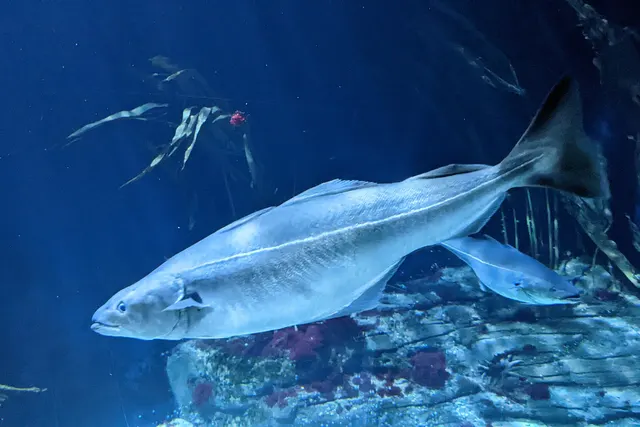 SaitheRegular local target8 placesSkinningrove jetty, Port Mulgrave, Scarborough Marine Drive, Scarborough South Bay pier and 4 moreOver bay, jetty, pier, promenadeAround Jan–Mar, Jun–Dec
 Ballan wrasseRegular local target4 placesFiley Brigg, Flamborough Head and the North Landing, Bridlington North Pier, Cloughton WykeOver headland, ledge, pier, rock markAround May–Oct
 PollackRegular local target4 placesCloughton Wyke, Scarborough South Bay pier, Bridlington North Pier, Whitby piersOver pier, rock markAround May–Oct
 Atlantic mackerelSeasonal7 placesFiley Brigg, Scarborough Marine Drive, Scarborough South Bay pier, Bridlington North Pier and 3 moreOver jetty, ledge, pier, promenade, rock markAround Jun–Sept
 WhitingSeasonal6 placesRunswick Bay, Robin Hood's Bay, Cayton Bay, Whitby piers and 2 moreOver bay, jetty, pierAround Jan–Feb, Nov–Dec
Also documented from the shore: European flounder · European sea bass · Dab · Small-spotted catshark
What these strengths mean
- Regular local target
- Fishing sources describe this as a normal local target here, not merely as caught.
- Seasonal
- Well supported, and concentrated in part of the year rather than spread through it.
- How breadth is counted
- A fish documented at six marks is shown as six marks: breadth never raises the strength on its own. A fishery account describes the fishing; a recorded catch reports one specific catch. How evidence is weighed.
How people fish here
6 methods are recorded on the places documented here, counted from the records themselves rather than from what is practised in the country. Each opens a full guide to the technique.
Ledgering
Recorded at 17 places here, over bay, pier, beach, headland.
Fishing a bait on the bottom held by a weight, with no float — the simplest way to fish at distance, in depth, or in wind.
Documented on the same ground: Atlantic cod, Ballan wrasse, Pollack, Saithe, Atlantic mackerel, Dab.
Float fishing
Recorded at 11 places here, over pier, bay, rock mark, cove.
Suspending a bait at a controlled depth beneath a buoyant indicator — the most visual, most controllable and most widely applicable method in angling.
Documented on the same ground: Atlantic cod, Ballan wrasse, Pollack, Atlantic mackerel, Dab, European flounder.
Spinning
Recorded at 6 places here, over rock mark, bay, cove, ledge.
Casting an artificial lure and retrieving it so that it moves like something alive — the most direct form of lure fishing.
Documented on the same ground: Atlantic cod, Ballan wrasse, Pollack, Atlantic mackerel, Dab, European flounder.
Surfcasting
Recorded at 2 places here, over jetty.
Casting heavy baited tackle from a beach into surf — a method defined by distance, by tide, and by reading water that all looks the same.
Documented on the same ground: Atlantic cod, Saithe, Atlantic mackerel, European flounder, Whiting.
Feathering and multi-lure traces
Recorded at 1 place here, over jetty.
A string of small lures on droppers, worked in the water column — how most people in Britain and Ireland catch their first sea fish, and the method most likely to catch far more than anybody intended.
Documented on the same ground: Saithe, Atlantic cod, Atlantic mackerel, European flounder, Whiting.
Kayak fishing
Recorded at 1 place here, over bay.
A platform rather than a technique: quiet, shallow-draught access to water no other craft reaches, bought at the price of exposure, and a discipline where the decision not to launch is part of the skill.
Documented on the same ground: Atlantic cod, Whiting, Saithe.
These are the methods documented at the places FishingHQ holds here. A species listed beside a method is documented on the same ground, which is not the same as being taken that way — where a source establishes the method a fish was caught on, it is stated on that place’s own page. All fishing methods.
The fishing year here
The months the records under this area actually name, tightest season first. This is “observed in these months” rather than a season: a species whose months nobody recorded is not listed, because a gap in the evidence is not a year-round fishery.
- Atlantic mackerelJune to September
- WhitingNovember to February
- DabJune to September
- Small-spotted catsharkJune to September
- Atlantic codOctober to March
- Ballan wrasseMay to October
- PollackMay to October
- European sea bassMay to October
- European flounderJanuary, February, June, July, August, September, November and December
- SaitheJune to March
What dominates
Rough-ground shore fishing from the scars and cliff ledges in the north — heavy ledgering with rotten-bottom rigs, and lure and float fishing for wrasse and pollack over the kelp. Clean-beach surfcasting along the Holderness coast and out to Spurn, weighted hard to autumn and winter. Small-boat and charter fishing out of the harbour towns to wreck and rough ground offshore, and to the codling grounds. Pier and harbour-wall fishing, which is where a great deal of this coast's fishing is actually done. Estuary bass, flounder and mullet fishing in the Humber and its creeks.
The water available
Wave-cut rock scars and kelp forest; Jurassic cliff and gully systems; a hard chalk headland with caves, stacks and deep water close in; rapidly eroding boulder-clay cliffs; long shallow-gradient sand and shingle beaches; a growing sand and shingle spit; a very large, turbid, strongly tidal estuary with mudflat, sandflat and saltmarsh; and offshore wreck and mixed ground on the shallow North Sea shelf.
How the rules are structured
Recreational sea angling in England is not licensed as freshwater angling is, but a substantial framework applies. Minimum conservation reference sizes and species-specific measures — bass measures in particular have changed repeatedly in recent years — are set nationally. Inshore byelaws are made by the Inshore Fisheries and Conservation Authority for the district and differ along this coast. Flamborough Head and much of the coast carries conservation designations for its cliffs, seabird colonies and marine habitats, and those designations constrain access, vehicles and collection independently of any fishing rule. The Humber carries its own protections and its own navigation and port controls. Bait collection on the estuary flats is separately regulated in places. FishingHQ does not state what any current rule is.
Who to ask
- The relevant Inshore Fisheries and Conservation Authority for the district, which makes and enforces inshore byelaws including those on bait collection.
- The Marine Management Organisation, for national recreational sea fishing measures in English waters.
- Natural England and the site management body, where a marine or coastal designation affects access, vehicles or collection.
- The harbour authority or commissioners at each port, where fishing is from harbour structures or small craft are launched.
- The statutory harbour authority for the Humber, for navigation and access on the estuary.
- The Maritime and Coastguard Agency and the RNLI, for safety guidance on this coast.
Words you will meet
- Scar
- A wave-cut rock platform running out from the foot of the cliff and exposed at low water. Scars are the defining shore-fishing ground of the northern half of this coast, and they are also the reason people are cut off on it: the platform floods from the seaward side and from behind at the same time.
- Codling
- A small cod, and on this coast the word carries a fishery rather than only a size. The autumn and winter codling run over rough ground is what the northern half of the coast is known for, and it is a fishery that has declined substantially within living memory.
- Rotten bottom
- A deliberately weak link between the lead and the rest of the rig, so that a lead jammed in the rock breaks free and the fish and the trace are recovered. Over the scars it is the difference between fishing the ground and losing tackle into it every cast.
- Coloured water
- Sediment-laden water after a sea has been running. On this coast, and particularly south of Flamborough where the cliffs are clay, a blow puts a great deal of material into suspension and it is generally the condition that produces the fishing rather than the one that spoils it.
Conditions and hazards
The northern half of this coast presents the two classic rock-coast mechanisms and both have killed people here. Wave-cut scars flood from the seaward side and from the landward side at once, so the way back closes before the platform covers, and a person concentrating on the fishing discovers it late. Cliff ledges and gully edges are wet, weeded and slippery, and a swell that has been comfortably below a platform for an hour arrives well above it in a set. The southern half is more dangerous than it looks for a different reason: boulder-clay cliffs are actively failing, they collapse without warning and are worst after rain, and sitting at the base of one out of the wind is the natural thing to do and the wrong one. Across the whole coast the North Sea is cold enough for most of the year that cold water shock, not swimming ability, decides what happens on immersion, and most of the fishing is done in autumn and winter, often at night. The Humber runs a strong tide over soft mud with commercial traffic in the channel, and mud that carried weight on the way out will not on the way back. A buoyancy aid worn rather than carried, not fishing alone, and a means of calling for help on the person rather than in a bag are the measures that address all of it.
Flamborough Head, and why one headland makes two coasts
Almost everything a visiting angler needs to know about this coast follows from one piece of geology, and it is worth understanding rather than memorising.
THE HEADLAND IS CHALK AND IT SURVIVES. Chalk is normally a soft rock that produces low, fast-retreating cliffs. The chalk here is harder and better cemented than the chalk of southern England, so it stands as a promontory several kilometres out into the North Sea while the softer material either side of it goes. That single fact organises the coast.
IT INTERRUPTS THE SEDIMENT. Longshore drift on this coast runs broadly southward. The headland blocks it, so material eroded from the north does not reach the south, and material eroded from the Holderness cliffs south of it is not replaced from above. That is one reason the southern coast is losing so fast: it is being drawn down without being fed.
IT FORCES THE TIDE. A stream running along a coast and meeting a promontory accelerates around it. That produces overfalls and rough water off the point, scour around its base, and — the part that matters to fishing — a persistent concentration of moving water and food that holds fish close to the headland when the open coast either side is quiet.
AND IT PUTS DEEP WATER AGAINST THE ROCK. Where the softer coast to the south shelves for a mile before it reaches anything, the headland drops away close in. That single change is why the north of this coast can be fished from the shore for species the south of it cannot.
WHAT CHANGES ACROSS IT, IN ORDER. North: rock scars, kelp, gullies, boulder ground, wrasse, codling over rough ground, pollack and coalfish, conger in the deep holes, and shore marks that can reach genuinely deep water. South: flat sand, almost no hard structure, a clean-beach fishery of codling, whiting, dab and flounder in winter and bass, smoothhound and rays in summer, and a very different set of rigs and leads to fish it with.
THE PRACTICAL CONSEQUENCE is that 'the Yorkshire coast' is not one plan. Tackle that is right for a scar is wrong for Holderness and the reverse, and the tide state that makes one work has no bearing on the other.
Backed by research — why, and the sources (4)
Supported by peer-reviewed research or fisheries science. The sources are listed and can be checked.
- Cefas science, advice and data on marine and freshwater environments — Centre for Environment, Fisheries and Aquaculture Science (Government fisheries body)Relied on for: Marine environmental science for UK shelf seas, including the physical characterisation of sediment, coastal process and the monitoring programmes that describe them.States this directlyCitation checked — the work exists and is described correctly
- ICES Advice on fishing opportunities, catch and effort — International Council for the Exploration of the Sea (Scientific institute)Relied on for: Ecoregion description, stock distribution and the hydrography of the sea areas assessed.States this directlyCitation checked — the work exists and is described correctly
- JNCC species and habitat conservation advice — Joint Nature Conservation Committee (Conservation authority)Relied on for: Designation, habitat description and conservation status of the marine, coastal and freshwater habitats named.States this directlyCitation checked — the work exists and is described correctly
- The Fishes of the British Isles and North-West Europe — Macmillan, 1969 (Reference work)Relied on for: Distribution, habitat association and biology of the fishes of the British Isles named here.States this directlyCitation checked — the work exists and is described correctly
A coast being deleted, and the spit that is made of it
The Holderness coast is retreating faster than any other coastline in Europe, and the material it loses builds something at the end of it. Both halves of that matter to anybody fishing here.
THE MATERIAL HAS ALMOST NO RESISTANCE. Holderness is boulder clay — an unsorted mass of clay, sand and stones dumped by ice — sitting on chalk that is mostly below sea level. Waves do not have to abrade it; they undercut it and it slumps. Rain saturates it and it slumps without any waves at all. Cliff faces here are frequently raw, unvegetated and freshly collapsed.
THE LOSS IS MEASURED IN METRES A YEAR, not centimetres, and it is documented over centuries: a long list of medieval villages named in the Domesday survey are now some distance offshore. Sea defences protect particular towns and, by holding the coast in one place, accelerate the loss immediately downdrift of them.
SPURN POINT IS THE OUTPUT. The eroded material moves south and accumulates at the mouth of the Humber as a long, narrow sand and shingle spit. It is not a stable landform: it grows, it is breached in surges, and it has been re-formed repeatedly. In one recent surge it was cut through and the road along it destroyed, and it has been managed as a tidal island since.
WHAT THIS MEANS FOR FISHING IT. Beach features on this coast — bars, gutters, scour holes — are not durable and may not survive a single winter. Access points and parking are withdrawn permanently when the land they are on goes. Local intelligence more than a season or two old is a hypothesis rather than a fact, which is a different relationship with local knowledge from the one a rock coast has. And the cliffs are not shelter: they are the failure plane.
THE HUMBER AT THE END OF IT is the other consequence. A vast quantity of fine sediment enters the estuary from this coast, which is a large part of why the Humber is so turbid, and turbidity is why it is a nursery: fine sediment carries food and poor visibility hides small fish.
Backed by research — why, and the sources (4)
Supported by peer-reviewed research or fisheries science. The sources are listed and can be checked.
- Cefas science, advice and data on marine and freshwater environments — Centre for Environment, Fisheries and Aquaculture Science (Government fisheries body)Relied on for: Marine environmental science for UK shelf seas, including the physical characterisation of sediment, coastal process and the monitoring programmes that describe them.States this directlyCitation checked — the work exists and is described correctly
- ICES Advice on fishing opportunities, catch and effort — International Council for the Exploration of the Sea (Scientific institute)Relied on for: Ecoregion description, stock distribution and the hydrography of the sea areas assessed.States this directlyCitation checked — the work exists and is described correctly
- JNCC species and habitat conservation advice — Joint Nature Conservation Committee (Conservation authority)Relied on for: Designation, habitat description and conservation status of the marine, coastal and freshwater habitats named.States this directlyCitation checked — the work exists and is described correctly
- The Fishes of the British Isles and North-West Europe — Macmillan, 1969 (Reference work)Relied on for: Distribution, habitat association and biology of the fishes of the British Isles named here.States this directlyCitation checked — the work exists and is described correctly
The codling coast, and what happened to it
Yorkshire's shore fishing reputation was built on a winter codling fishery over rough ground, and being honest about its present state is more useful than repeating its reputation.
THE SEASON IS A TEMPERATURE. Cod move inshore as the shallow North Sea cools through autumn, and the timing follows water temperature rather than the calendar. A warm autumn delays it. Anglers on this coast have watched the reliable opening of that season move later and become less certain over decades, and that is a measurable change rather than nostalgia.
ROUGH WEATHER IS THE TRIGGER WITHIN THE SEASON. A sea that has been running lifts worm, crab and shellfish out of the ground and holds them in suspension; the fish come in to it. The productive session is generally on a dropping sea rather than at the height of it, and flat calm clear water in December is usually poor.
THE STOCK PICTURE IS NOT COMFORTABLE. North Sea cod has been under sustained management concern and recovery effort for decades. The decline in the shore fishery is not an artefact of anglers fishing worse or of the fish becoming cleverer. What may be retained, and at what size, is a matter for the responsible authority and it changes, which is why this page does not state it.
WHAT IS ACTUALLY THERE NOW, THROUGH A YEAR. Winter on the open ground: whiting and dab in numbers, codling in fewer numbers than the reputation implies, flounder in the estuary and its approaches. Spring: the rough ground begins to fish for wrasse as the water warms, and thornback and other rays appear over the cleaner ground. Summer: bass along the whole coast and strongly into the Humber, smoothhound over the clean ground on crab, mackerel inshore in settled warm spells, pollack and coalfish over the kelp and around the headland. Autumn: the best of the year on most of it, as the water is still warm and the weather has begun to move.
AND THE NORTH AND THE SOUTH RUN DIFFERENT CALENDARS. The rough ground in the north holds resident fish — wrasse, pollack, conger — through the warm months, so it has a summer fishery that the clean southern beaches largely do not. The southern beaches, in exchange, are far better through the winter when the rock is unfishable in any real sea.
What experienced anglers do — why, and the sources (4)
Widely and independently recommended by experienced anglers and specialist sources. This is real angling knowledge, not proof: controlled evidence for it is limited, and FishingHQ records it as convention rather than as a demonstrated effect.
- Fishers' Craft and Lettered Art: Tracts on Fishing from the End of the Middle Ages — University of Toronto Press, 1997 (Scientific literature)Relied on for: That fishing traditions develop around the water and fish available to them, and the historical method of reading such traditions.States this directlyCitation checked — the work exists and is described correctly
- General angling website restatements of established technique — Various (Credible secondary source)Relied on for: Widely restated descriptions of regional angling practice, recorded as practitioner consensus rather than as scholarship.Background and mechanism onlyCitation checked — the work exists and is described correctly
- Cefas science, advice and data on marine and freshwater environments — Centre for Environment, Fisheries and Aquaculture Science (Government fisheries body)Relied on for: Marine environmental science for UK shelf seas, including the physical characterisation of sediment, coastal process and the monitoring programmes that describe them.States this directlyCitation checked — the work exists and is described correctly
- ICES Advice on fishing opportunities, catch and effort — International Council for the Exploration of the Sea (Scientific institute)Relied on for: Ecoregion description, stock distribution and the hydrography of the sea areas assessed.States this directlyCitation checked — the work exists and is described correctly
Fishing a scar, and the way it catches people out
The wave-cut rock platforms of the northern half of this coast are the best shore ground on it and the reason it has a rescue history. The two facts are the same fact.
WHAT A SCAR IS. A flat shelf of rock cut by wave action at around the level of the tide, running out from the foot of the cliff, exposed at low water and covered at high. Its surface is fissured into gullies, holed with pools, and generally weeded, and its outer edge drops into deeper water and kelp. That edge is the fishing.
WHY IT HOLDS FISH. A gully or a hole full of water at low tide holds crab, prawn, small wrasse and blennies through the ebb, and the flood brings predators onto the platform to work them. Kelp on the outer edge holds wrasse and pollack permanently. Broken ground beyond it holds conger and, in season, codling.
HOW IT FLOODS. This is the part to understand before going out on one. A scar does not fill like a bath from the outside in. Water comes over the outer edge and it also runs up the gullies behind the platform and fills the low ground between the scar and the cliff. So the route back closes before the platform you are standing on covers, and it closes out of sight behind you while you are facing the sea.
WHAT ADDRESSES IT. Walk the route out and note where the low ground is. Fix a time to leave by the tide rather than by the fishing. Do not go out onto a scar on a rising tide at all unless the exit is above the high-water line for the whole session. Watch the sea for a full set of waves before committing to any position — the swell that has been comfortably below a ledge for twenty minutes arrives above it in a set, and that mechanism, rather than falling in, is how most rock anglers end up in the water.
AND WEAR THE BUOYANCY AID. Cold water shock takes breathing control within seconds in North Sea temperatures, and a person who is gasping cannot swim, cannot climb out onto weeded rock and cannot call for help. A means of calling for help belongs on the person and not in the bag on the rock.
What experienced anglers do — why, and the sources (4)
Widely and independently recommended by experienced anglers and specialist sources. This is real angling knowledge, not proof: controlled evidence for it is limited, and FishingHQ records it as convention rather than as a demonstrated effect.
- Rock fishing safety and the declared lifejacket areas of New South Wales — NSW Department of Primary Industries and Surf Life Saving NSW (Water-safety or diver-training authority)Relied on for: Rock-platform fishing hazards, the mechanism by which anglers are swept, and the measures that address it including buoyancy aids and observation before committing to a platform.States this directlyCitation checked — the work exists and is described correctly
- RNLI water safety guidance: cold water shock and Float to Live — Royal National Lifeboat Institution (Water-safety or diver-training authority)Relied on for: Cold water shock, immersion response and the advice to carry a means of calling for help on the person.States this directlyPassage read and verified
- Fishers' Craft and Lettered Art: Tracts on Fishing from the End of the Middle Ages — University of Toronto Press, 1997 (Scientific literature)Relied on for: That fishing traditions develop around the water and fish available to them, and the historical method of reading such traditions.States this directlyCitation checked — the work exists and is described correctly
- General angling website restatements of established technique — Various (Credible secondary source)Relied on for: Widely restated descriptions of regional angling practice, recorded as practitioner consensus rather than as scholarship.Background and mechanism onlyCitation checked — the work exists and is described correctly
Two coasts under one name, with opposite dangers
The Yorkshire coast is treated as one place and is physically two, and the hazard on each is not merely different from the other but close to its inverse.
NORTH OF FILEY IT IS HARD ROCK. Cliffs, wave-cut scars running out from their base, and deep water close in. The danger is the sea reaching a position that looked dry, and it does that in two ways. A rock scar floods from its seaward edge AND from the low ground behind it at the same time, so the route back closes while the platform is still dry and while the angler is facing out to sea. And swell arrives in sets: a ledge that has been comfortably clear for twenty minutes is not evidence about the next wave, because the largest wave in a set is substantially larger than the average and the set is what takes people off.
SOUTH OF FLAMBOROUGH IT IS SOFT CLAY. Holderness is among the fastest-eroding coastlines in Europe, and boulder-clay cliffs do not weather gradually; they slump, without warning, onto whatever is at their base. Saturated clay after prolonged rain is the condition to avoid, and the cliff edge above is undercut for the same reason. Nothing about this coast rewards sheltering under a cliff or setting up at its foot.
THE HUMBER IS A THIRD THING AGAIN. Strong tidal streams over extensive soft mudflats with a commercial navigation channel running through. Mud that bears weight on the ebb may not on the return, the flats fill from behind, and shipping in the channel cannot manoeuvre around a person or a small craft.
COLD RUNS UNDERNEATH ALL THREE, AND SO DOES THE FISHING CULTURE. This fishery is weighted to autumn and winter and frequently to night, which is when the North Sea is coldest and when nobody sees an entry. Cold water shock removes breathing control within seconds, before cold has had any effect on the muscles at all, which is why competent swimmers drown close to shore.
WHAT ACTUALLY HELPS is knowing which of the three coasts you are on, walking the exit before fishing a scar and setting a leaving time from the tide, watching the sea for a full set before committing to any rock position and choosing one with a way UP rather than only a way to stand, staying off and away from clay cliffs entirely, wearing a buoyancy aid rather than carrying one, not fishing alone at night, and carrying a means of calling for help on the person rather than in a bag at the top of the beach.
Official guidance — why, and the sources (3)
Stated by a fisheries authority, scientific institute or recognised angling body. Authoritative, but summarising rather than demonstrating.
- Rock fishing safety and the declared lifejacket areas of New South Wales — NSW Department of Primary Industries and Surf Life Saving NSW (Water-safety or diver-training authority)Relied on for: Rock-platform fishing hazards, the mechanism by which anglers are swept from platforms by sets rather than by average conditions, and the measures that address it including buoyancy aids and observing the sea before committing to a position.States this directlyCitation checked — the work exists and is described correctly
- RNLI water safety guidance: cold water shock and Float to Live — Royal National Lifeboat Institution (Water-safety or diver-training authority)Relied on for: Cold water shock and the immersion response, tidal cut-off, and water-safety guidance for shore anglers and small-craft users.States this directlyPassage read and verified
- Cefas science, advice and data on marine and freshwater environments — Centre for Environment, Fisheries and Aquaculture Science (Government fisheries body)Relied on for: Marine environmental science for UK shelf seas, including tidal range, coastal process, sediment characterisation and the monitoring programmes that describe them.States this directlyCitation checked — the work exists and is described correctly
Some of what lives here
Fish recorded here that FishingHQ holds a reviewed photograph of. It is not a complete list of what The Yorkshire coast holds, and it is not a prediction that you will catch any of them — it is a way in to the ones we can show you.
- Atlantic codA large, heavily-built demersal predator of the North Atlantic, and the species whose commercial history is the standard example of stock collapse.
The U.S. Food and Drug Administration, Public domain, via Wikimedia Commons
- WhitingA small, abundant, silver gadoid of European coasts, a mainstay of winter shore fishing and distinguished by a dark spot at the pectoral fin base.
rmjb — CC BY, via iNaturalist
- Ballan wrasseA long-lived rocky-ground resident that begins life female and may change sex — and the species that turned rock marks into a lure fishery.
Diego Delso — CC BY-SA 4.0, via Wikimedia Commons
- PollackA fast gadoid that hunts up off reefs and wrecks and takes a lure on the drop — and the sea fish most likely to convert a bait angler to lure fishing.
Wilhelm Thomas Fiege — CC BY-SA 4.0, via Wikimedia Commons
 Conger eelA very large scaleless eel of wrecks, rock and harbour walls, reaching three metres, and among the most powerful and most genuinely dangerous fish to handle in European seas.
Holger Krisp — CC BY 3.0, via Wikimedia Commons
 European sea bassA fast, predatory inshore fish that hunts in broken water and surf, and one of the most closely managed recreational species in European seas.
Julien Renoult — CC BY 4.0, via Wikimedia Commons
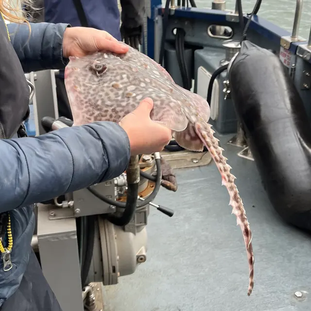 Thornback rayThe commonest European ray, covered in thorn-like bucklers, laying horny egg cases known as mermaid's purses, and requiring careful handling on release.
Ella McCausland — CC BY, via iNaturalist
 European flounderThe flatfish that runs up rivers — a tolerant, estuarine right-eyed flounder with bony tubercles along its fin bases and a habit of turning up in fresh water.
nbasargin — CC BY, via iNaturalist
Places within this area
Publicly documented fishing geography. FishingHQ describes what the ground is; it does not say whether you may fish it, and every one of these sends that question to the body that holds the answer. Browse every place in this part of the world.
Who to ask before fishing any of these
FishingHQ does not know the current access position here. Shore angling in England is not rod-licensed, but access rights, landowner permission, local authority and harbour byelaws, national and inshore fisheries measures, and site designations all apply and all change. Check the current position with the relevant inshore fisheries and conservation authority, the harbour or local authority, and the landowner before going.
FishingHQ does not know the current access position here. Shore angling in England is not rod-licensed, but access rights, landowner permission, local authority and harbour byelaws, national and inshore fisheries measures, and site designations all apply and all change. Check the current position with the relevant inshore fisheries and conservation authority, the harbour or local authority, and the landowner before going. This water is tidal and transitional, so the freshwater regime may also apply above the tidal limit: FishingHQ does not know the current access position here. Freshwater rod fishing in England requires a current rod licence AND separate permission from whoever controls the fishing, which is frequently a club, riparian owner or navigation authority rather than a public body. Close seasons, byelaws and local rules apply and change. Check with the Environment Agency and with the controlling club or owner before going.
Filey Brigg
Ledge · Salt water
A natural rock reef of calcareous grit running roughly a kilometre out to sea from the end of Carr Naze, with a flat scar top, deep gullies along both flanks and heavy kelp. One of the most distinctive pieces of shore-fishing ground on the English east coast because it puts an angler a kilometre offshore on foot.
Wholly exposed. The Brigg is a low reef surrounded by open North Sea and there is no lee anywhere on it; a swell from any northerly or easterly quarter breaks across the whole structure.
Particular to this ground: tides and being cut off, cliffs and rock platforms, cold water shock.
Particular to this water: This ground carries conservation designations that constrain access, vehicles, bait collection and disturbance independently of any fishing rule.
Flamborough Head and the North Landing
Headland · Salt water
A chalk headland — the only chalk sea cliff in northern England — projecting six kilometres into the North Sea, with wave-cut chalk platforms, caves, stacks and boulder aprons beneath cliffs of up to a hundred metres. The chalk gives clean white ground and unusually clear water for the east coast.
The headland divides two coasts with different weather. The north face is exposed to northerlies and sheltered from the south; the south face is the reverse. That is the single most useful practical fact about the place.
Particular to this ground: cliffs and rock platforms, cliffs and rock platforms, tides and being cut off.
Severe hazards of The Yorkshire coast apply here: cold water shock.
Particular to this water: This ground carries conservation designations that constrain access, vehicles, bait collection and disturbance independently of any fishing rule.
Spurn Point
Headland · Brackish water
A five-kilometre sand and shingle spit curling west into the mouth of the Humber, breached and reshaped by storms and functionally an island at high water since 2013. Clean sand on the seaward side, mud and sand flats inside, and the Binks — a shifting shingle and sand bank — off the end.
The seaward side takes the full southern North Sea; the Humber side is sheltered from everything except a westerly blowing down the estuary against the ebb.
Particular to this ground: tides and being cut off, cold water shock, boat traffic and being seen.
Severe hazards of The Yorkshire coast apply here: cliffs and rock platforms.
Particular to this water: This ground carries conservation designations that constrain access, vehicles, bait collection and disturbance independently of any fishing rule.
Staithes
Cove · Salt water
A narrow beck mouth cut into Jurassic shale and ironstone, with steep rock scars running out on both sides of the harbour and boulder ground beneath the cliffs.
Severe hazards of The Yorkshire coast apply here: tides and being cut off, cliffs and rock platforms, cold water shock.
Runswick Bay
Bay · Salt water
A sheltered north-facing sand bay held between two shale headlands, with extensive alum-shale scars at both ends and one of the few genuine lees on this coast in a south-westerly.
Severe hazards of The Yorkshire coast apply here: tides and being cut off, cliffs and rock platforms, cold water shock.
Robin Hood's Bay
Bay · Salt water
A great arc of wave-cut shale scars uncovering hundreds of metres at low water, ribbed into concentric arcs by the eroded flank of a dome — the most extensive rock platform on the Yorkshire coast.
Particular to this ground: tides and being cut off.
Severe hazards of The Yorkshire coast apply here: cliffs and rock platforms, cold water shock.
Ravenscar and the Peak rocks
Rock mark · Salt water
Boulder-strewn shale ground beneath a two-hundred-metre cliff, reached by a long steep descent, with heavy kelp and broken rock giving way to sand well offshore.
Severe hazards of The Yorkshire coast apply here: tides and being cut off, cliffs and rock platforms, cold water shock.
Scarborough Marine Drive
Promenade · Salt water
A high sea wall carried round the sandstone headland between Scarborough's two bays, standing over broken rock and kelp with sand a short way out.
Severe hazards of The Yorkshire coast apply here: tides and being cut off, cliffs and rock platforms, cold water shock.
9 more places in this area
Scarborough South Bay pier
Pier · Salt water
The stone harbour arms of a working fishing port, enclosing a sand-floored basin with the castle headland's rock ground immediately outside.
Severe hazards of The Yorkshire coast apply here: tides and being cut off, cliffs and rock platforms, cold water shock.
Cayton Bay
Bay · Salt water
A landslipped bay where soft glacial till slumps over Jurassic clay, giving broken mixed ground, boulder runs and patches of clean sand beneath an unstable wooded cliff.
Severe hazards of The Yorkshire coast apply here: tides and being cut off, cliffs and rock platforms, cold water shock.
Bridlington North Pier
Pier · Salt water
The northern arm of a harbour sitting exactly on the geological hinge of the coast, with chalk ground to the north and the soft clay of Holderness beginning immediately south.
Severe hazards of The Yorkshire coast apply here: tides and being cut off, cliffs and rock platforms, cold water shock.
Hornsea
Beach · Salt water
Steep sand and shingle over soft boulder clay on the fastest-eroding coast in Europe, where the beach is fed continuously by the cliff behind it and the ground offshore is soft and featureless.
Severe hazards of The Yorkshire coast apply here: tides and being cut off, cliffs and rock platforms, cold water shock.
Withernsea
Beach · Salt water
A defended clay coast where groynes and revetment hold a narrow sand and shingle strip against erosion, with soft ground and strong longshore drift running south towards Spurn.
Severe hazards of The Yorkshire coast apply here: tides and being cut off, cliffs and rock platforms, cold water shock.
Whitby piers
Pier · Salt water
The two stone piers running out either side of the Esk mouth, with the harbour channel between them and mixed ground beyond. Structure on both faces and enough water at the ends to fish without distance, which is what separates a pier mark from the beaches either side of it.
Open to the north-east, which is the quarter this coast takes its weather from, and the piers are unfishable in the sea that brings the cod.
Particular to this ground: cold water shock, slips, trips and falls.
Severe hazards of The Yorkshire coast apply here: tides and being cut off, cliffs and rock platforms.
Particular to this water: This is an owned and operated structure. Whether angling is allowed on it, when, from where and on what terms is the operator's decision, is frequently seasonal, and changes without notice.
Cloughton Wyke
Rock mark · Salt water
Rough rock north of Scarborough with deep water close in and a long walk to reach it. Broken ground throughout, which decides the tackle before anything else does: heavy gear and a weak link, on the assumption that leads will be lost.
Open to the north-east with no shelter, and rough ground taking the sea directly.
Particular to this ground: tides and being cut off, cold water shock, cliffs and rock platforms.
Particular to this water: This ground carries conservation designations that constrain access, vehicles, bait collection and disturbance independently of any fishing rule.
Skinningrove jetty
Jetty · Salt water
The stub of the old ironstone jetty at the Kilton Beck mouth, with slag and mine waste making up much of the foreshore and rough ground either side. A hard, artificial shore under high cliffs.
Open north-east into the North Sea below the highest cliffs in England.
Particular to this ground: cliffs and rock platforms, cold water shock.
Severe hazards of The Yorkshire coast apply here: tides and being cut off.
Port Mulgrave
Jetty · Salt water
The ruined harbour of a Victorian ironstone port under the cliffs, reached only by a steep path down the undercliff, with the broken pier arms and boulder ground below. Deep water and heavy rough ground, in the dark, at the bottom of a climb.
Open north into the North Sea below high cliffs.
Particular to this ground: cliffs and rock platforms, cold water shock, cliffs and rock platforms.
Severe hazards of The Yorkshire coast apply here: tides and being cut off.
Safety
Tides and being cut off — Can cause serious injury or death
Wave-cut rock scars flood from the seaward edge and from behind at the same time, so the route back across the low ground between the platform and the cliff closes while the platform is still dry and while the angler is facing the sea.
What reduces it: Walk the exit before fishing and note the low ground. Set a leaving time from the tide rather than from the fishing. Do not go out onto a scar on a rising tide unless the exit stays above water for the whole session.
Worse when:
- Spring tides, when the platform covers faster and further.
- In the dark, when the low ground behind cannot be seen filling.
Cliffs and rock platforms — Can cause serious injury or death
On the northern rock coast, a swell that has been below a ledge for twenty minutes arrives above it in a set and takes a person off it. On the southern clay coast, boulder-clay cliffs collapse without warning onto whatever is at their base.
What reduces it: Watch the sea for a full set before committing to any rock position, and choose a position with a way up rather than only a way to stand. Never shelter, sit or set up beneath a clay cliff, and keep back from the cliff edge above, which is undercut.
Worse when:
- Long-period swell, which arrives in sets far larger than the average.
- After heavy or prolonged rain, when saturated boulder clay slumps.
Cold water shock — Can cause serious injury or death
The North Sea here is cold for most of the year and this fishery is weighted to autumn and winter, frequently at night. Immersion produces an involuntary gasp and loss of breathing control within seconds, which removes the ability to swim or to climb out.
What reduces it: Wear a buoyancy aid rather than carry one, do not fish alone, carry a means of calling for help on the person, and tell somebody the mark and the return time.
Drowning and immersion — Can cause injury needing treatment
The Humber runs a strong tidal stream over extensive soft mudflats with commercial traffic in the channel. Mud that carries weight on the ebb will not on the return, and the flats fill from behind as well as from the front.
What reduces it: Know the state of the tide and the exit before going onto the flats, leave by a set time rather than when the fishing slows, and keep well clear of the navigation channel.
Check the rules before you fish
Fishing laws, bylaws, access rules, seasons, bait restrictions and permitted methods vary by location and can change. Check the current rules from the relevant authority and the water you intend to fish before fishing.
Check with:
- Current national or regional law for where you are fishing
- Current local bylaws
- The relevant fisheries authority
- The landowner, club or fishery whose water it is
- Any restrictions specific to the species or the method you intend to use
Where to go next
What swims here
- Atlantic codThe autumn and winter inshore movement onto the rough ground and the open beaches of this coast is the fishery Yorkshire is known for. The association is with cooling water and disturbed seas rather than with a month, and the abundance is a fraction of what it was.
- Ballan wrasseResident on the kelp and boulder ground of the wave-cut scars north of Flamborough and around the headland itself, through the warmer months. The clean southern beaches hold none, which is the clearest single expression of what the headland separates.
- Conger eelIn the deeper holes and broken ground of the northern scars and around wreck offshore, rather than on the clean southern coast which offers nothing for it to lie in.
- DabOver the clean sand of the Holderness beaches and the cleaner ground between the northern scars, through autumn and winter.
- European flounderThroughout the Humber and its creeks and out onto the adjacent beaches. The turbid, food-rich estuary is exactly the habitat, and flounder are present through the year where cod are not.
- European sea bassAlong the whole coast in the warmer months and strongly into the Humber, which is a significant nursery. This is near the northern edge of the species' consistent range on the English east coast.
- PollackOver the kelp edges and gully ground of the northern rock coast and around the deep water off the chalk headland.
- Starry smooth-houndOver the clean sand and mixed ground of the southern half of the coast in summer, where the crab it feeds on is abundant.
2 more
- Thornback ray Fish
- Whiting Fish
How this compares
- The Norfolk and Suffolk sandbank coastTwo soft, fast-eroding English coasts of glacial till fed by southward drift, with quite different offshore arrangements: East Anglia's fishing is organised by a field of sandbanks, Yorkshire's southern half has none.
- The north-east England coastThe two halves of the English North Sea rock coast. North-east England is hard rock throughout; Yorkshire is hard rock only until the chalk headland, and then it is not rock at all. Reading them together shows what the headland actually does.
Environment and conservation
Sources and evidence
- Cefas science, advice and data on marine and freshwater environments — Centre for Environment, Fisheries and Aquaculture Science (Government fisheries body)Relied on for: Marine environmental science for UK shelf seas, including the physical characterisation of sediment, coastal process and the monitoring programmes that describe them.States this directlyCitation checked — the work exists and is described correctly
- ICES Advice on fishing opportunities, catch and effort — International Council for the Exploration of the Sea (Scientific institute)Relied on for: Ecoregion description, stock distribution and the hydrography of the sea areas assessed.States this directlyCitation checked — the work exists and is described correctly
- JNCC species and habitat conservation advice — Joint Nature Conservation Committee (Conservation authority)Relied on for: Designation, habitat description and conservation status of the marine, coastal and freshwater habitats named.States this directlyCitation checked — the work exists and is described correctly
- The Fishes of the British Isles and North-West Europe — Macmillan, 1969 (Reference work)Relied on for: Distribution, habitat association and biology of the fishes of the British Isles named here.States this directlyCitation checked — the work exists and is described correctly
- RNLI water safety guidance: cold water shock and Float to Live — Royal National Lifeboat Institution (Water-safety or diver-training authority)Relied on for: Cold water shock and the immersion response, tidal cut-off, and water-safety guidance for shore anglers and small-craft users.States this directlyPassage read and verified
- Met Office shipping forecast, inshore waters forecast and marine warnings — Met Office, United Kingdom (Government fisheries body)Relied on for: That inshore waters forecasts, sea state and swell are the operative inputs for shore and small-craft decisions in these waters.States this directlyCitation checked — the work exists and is described correctly
Why the 14 connections on this page are here, and the sources
What swims here
Backed by research — 10 connections
Supported by peer-reviewed research or fisheries science. The sources are listed and can be checked.
Atlantic cod
A claim that a place contains the ground, water and seasonal conditions the species is associated with. It is a distributional statement about the world, it rests on the regional reference literature, and it deliberately asserts nothing about access, permission or catch.
- The Fishes of the British Isles and North-West Europe — Macmillan, 1969 (Reference work)Relied on for: Distribution and habitat association of the marine, estuarine and freshwater fishes of the British Isles, including which coasts and ground types a species occupies.States this directlyCitation checked — the work exists and is described correctly
- FishBase: a global information system on fishes — Froese, R. and D. Pauly, eds. — FishBase Consortium (Scientific institute)Relied on for: Recorded distribution, depth range and habitat association for the species named.States this directlyPassage read and verified
Ballan wrasse
A claim that a place contains the ground, water and seasonal conditions the species is associated with. It is a distributional statement about the world, it rests on the regional reference literature, and it deliberately asserts nothing about access, permission or catch.
- The Fishes of the British Isles and North-West Europe — Macmillan, 1969 (Reference work)Relied on for: Distribution and habitat association of the marine, estuarine and freshwater fishes of the British Isles, including which coasts and ground types a species occupies.States this directlyCitation checked — the work exists and is described correctly
- FishBase: a global information system on fishes — Froese, R. and D. Pauly, eds. — FishBase Consortium (Scientific institute)Relied on for: Recorded distribution, depth range and habitat association for the species named.States this directlyPassage read and verified
Conger eel
A claim that a place contains the ground, water and seasonal conditions the species is associated with. It is a distributional statement about the world, it rests on the regional reference literature, and it deliberately asserts nothing about access, permission or catch.
- The Fishes of the British Isles and North-West Europe — Macmillan, 1969 (Reference work)Relied on for: Distribution and habitat association of the marine, estuarine and freshwater fishes of the British Isles, including which coasts and ground types a species occupies.States this directlyCitation checked — the work exists and is described correctly
- FishBase: a global information system on fishes — Froese, R. and D. Pauly, eds. — FishBase Consortium (Scientific institute)Relied on for: Recorded distribution, depth range and habitat association for the species named.States this directlyPassage read and verified
Dab
A claim that a place contains the ground, water and seasonal conditions the species is associated with. It is a distributional statement about the world, it rests on the regional reference literature, and it deliberately asserts nothing about access, permission or catch.
- The Fishes of the British Isles and North-West Europe — Macmillan, 1969 (Reference work)Relied on for: Distribution and habitat association of the marine, estuarine and freshwater fishes of the British Isles, including which coasts and ground types a species occupies.States this directlyCitation checked — the work exists and is described correctly
- FishBase: a global information system on fishes — Froese, R. and D. Pauly, eds. — FishBase Consortium (Scientific institute)Relied on for: Recorded distribution, depth range and habitat association for the species named.States this directlyPassage read and verified
European flounder
A claim that a place contains the ground, water and seasonal conditions the species is associated with. It is a distributional statement about the world, it rests on the regional reference literature, and it deliberately asserts nothing about access, permission or catch.
- The Fishes of the British Isles and North-West Europe — Macmillan, 1969 (Reference work)Relied on for: Distribution and habitat association of the marine, estuarine and freshwater fishes of the British Isles, including which coasts and ground types a species occupies.States this directlyCitation checked — the work exists and is described correctly
- FishBase: a global information system on fishes — Froese, R. and D. Pauly, eds. — FishBase Consortium (Scientific institute)Relied on for: Recorded distribution, depth range and habitat association for the species named.States this directlyPassage read and verified
European sea bass
A claim that a place contains the ground, water and seasonal conditions the species is associated with. It is a distributional statement about the world, it rests on the regional reference literature, and it deliberately asserts nothing about access, permission or catch.
- The Fishes of the British Isles and North-West Europe — Macmillan, 1969 (Reference work)Relied on for: Distribution and habitat association of the marine, estuarine and freshwater fishes of the British Isles, including which coasts and ground types a species occupies.States this directlyCitation checked — the work exists and is described correctly
- FishBase: a global information system on fishes — Froese, R. and D. Pauly, eds. — FishBase Consortium (Scientific institute)Relied on for: Recorded distribution, depth range and habitat association for the species named.States this directlyPassage read and verified
Pollack
A claim that a place contains the ground, water and seasonal conditions the species is associated with. It is a distributional statement about the world, it rests on the regional reference literature, and it deliberately asserts nothing about access, permission or catch.
- The Fishes of the British Isles and North-West Europe — Macmillan, 1969 (Reference work)Relied on for: Distribution and habitat association of the marine, estuarine and freshwater fishes of the British Isles, including which coasts and ground types a species occupies.States this directlyCitation checked — the work exists and is described correctly
- FishBase: a global information system on fishes — Froese, R. and D. Pauly, eds. — FishBase Consortium (Scientific institute)Relied on for: Recorded distribution, depth range and habitat association for the species named.States this directlyPassage read and verified
Starry smooth-hound
A claim that a place contains the ground, water and seasonal conditions the species is associated with. It is a distributional statement about the world, it rests on the regional reference literature, and it deliberately asserts nothing about access, permission or catch.
- The Fishes of the British Isles and North-West Europe — Macmillan, 1969 (Reference work)Relied on for: Distribution and habitat association of the marine, estuarine and freshwater fishes of the British Isles, including which coasts and ground types a species occupies.States this directlyCitation checked — the work exists and is described correctly
- FishBase: a global information system on fishes — Froese, R. and D. Pauly, eds. — FishBase Consortium (Scientific institute)Relied on for: Recorded distribution, depth range and habitat association for the species named.States this directlyPassage read and verified
Thornback ray
A claim that a place contains the ground, water and seasonal conditions the species is associated with. It is a distributional statement about the world, it rests on the regional reference literature, and it deliberately asserts nothing about access, permission or catch.
- The Fishes of the British Isles and North-West Europe — Macmillan, 1969 (Reference work)Relied on for: Distribution and habitat association of the marine, estuarine and freshwater fishes of the British Isles, including which coasts and ground types a species occupies.States this directlyCitation checked — the work exists and is described correctly
- FishBase: a global information system on fishes — Froese, R. and D. Pauly, eds. — FishBase Consortium (Scientific institute)Relied on for: Recorded distribution, depth range and habitat association for the species named.States this directlyPassage read and verified
Whiting
A claim that a place contains the ground, water and seasonal conditions the species is associated with. It is a distributional statement about the world, it rests on the regional reference literature, and it deliberately asserts nothing about access, permission or catch.
- The Fishes of the British Isles and North-West Europe — Macmillan, 1969 (Reference work)Relied on for: Distribution and habitat association of the marine, estuarine and freshwater fishes of the British Isles, including which coasts and ground types a species occupies.States this directlyCitation checked — the work exists and is described correctly
- FishBase: a global information system on fishes — Froese, R. and D. Pauly, eds. — FishBase Consortium (Scientific institute)Relied on for: Recorded distribution, depth range and habitat association for the species named.States this directlyPassage read and verified
How people fish here
What experienced anglers do — 1 connection
Widely and independently recommended by experienced anglers and specialist sources. This is real angling knowledge, not proof: controlled evidence for it is limited, and FishingHQ records it as convention rather than as a demonstrated effect.
Sea fishing
A claim about angling convention rather than about the world: that this place sits within this branch of fishing, which drives the information architecture as well as the page. It rests on independent practitioner description.
- General angling website restatements of established technique — Various (Credible secondary source)Relied on for: Widely restated descriptions of which practices are conventionally used in the waters named, recorded as practitioner consensus rather than as scholarship.Background and mechanism onlyCitation checked — the work exists and is described correctly
- Sea Angler — Bauer Media (Specialist angling publication)Relied on for: Long-running published description of British sea angling practice by region and by ground type.FishingHQ's interpretation of what it saysCitation checked — the work exists and is described correctly
How this compares
What experienced anglers do — 2 connections
Widely and independently recommended by experienced anglers and specialist sources. This is real angling knowledge, not proof: controlled evidence for it is limited, and FishingHQ records it as convention rather than as a demonstrated effect.
The Norfolk and Suffolk sandbank coast
A claim that two places are worth reading against one another, because a reader choosing between them or generalising from one to the other needs to know how the underlying process differs.
- General angling website restatements of established technique — Various (Credible secondary source)Relied on for: Widely restated descriptions of which practices are conventionally used in the waters named, recorded as practitioner consensus rather than as scholarship.Background and mechanism onlyCitation checked — the work exists and is described correctly
- Sea Angler — Bauer Media (Specialist angling publication)Relied on for: Long-running published description of British sea angling practice by region and by ground type.FishingHQ's interpretation of what it saysCitation checked — the work exists and is described correctly
The north-east England coast
A claim that two places are worth reading against one another, because a reader choosing between them or generalising from one to the other needs to know how the underlying process differs.
- General angling website restatements of established technique — Various (Credible secondary source)Relied on for: Widely restated descriptions of which practices are conventionally used in the waters named, recorded as practitioner consensus rather than as scholarship.Background and mechanism onlyCitation checked — the work exists and is described correctly
- Sea Angler — Bauer Media (Specialist angling publication)Relied on for: Long-running published description of British sea angling practice by region and by ground type.FishingHQ's interpretation of what it saysCitation checked — the work exists and is described correctly
Environment and conservation
Backed by research — 1 connection
Supported by peer-reviewed research or fisheries science. The sources are listed and can be checked.
Fish stocks and sustainability
A claim that a place raises a particular environmental question, resting on the scientific and conservation literature for the system rather than on angling practice.
- JNCC species and habitat conservation advice — Joint Nature Conservation Committee (Conservation authority)Relied on for: Habitat classification and description for the intertidal, coastal and freshwater habitats named, and the species characteristically associated with them.States this directlyCitation checked — the work exists and is described correctly
- Cefas science, advice and data on marine and freshwater environments — Centre for Environment, Fisheries and Aquaculture Science (Government fisheries body)Relied on for: Characterisation of UK inshore sediment, intertidal habitat and the shellfish beds associated with them.States this directlyCitation checked — the work exists and is described correctly
How FishingHQ labels evidence is explained in the evidence policy.