The north-east England coast
Fishing regions · Last reviewed 2026-08-15
Hard rock scars alternating with sand bays down the cold western edge of the North Sea — a coast where the ground changes every few hundred metres and the fishery changes with it.
Safety: cliffs and rock platforms — can cause serious injury or death. 7 more points apply here.
Being listed here is not permission to fish. What that meansClose
Access, fishing rights, seasons, licences, local bylaws and permitted methods vary and can change. Check current access, permission, local regulations, closures and restrictions before you travel or fish. FishingHQ describes what the ground is and names who holds the answer; it does not hold the answer itself.
Find the authority for a jurisdiction · What FishingHQ does and does not cover
The coast from the Humber north to the Tweed is a coast-tier case because its geology alternates at a scale a shore angler can walk, and every alternation changes the fishing.
THE STRUCTURE IS HARD ROCK INTERRUPTED BY SOFT MATERIAL. Limestone, sandstone and shale form headlands, wave-cut platforms and the flat reefs known locally as scars, which run out from the shore and dry over a low spring tide. Between and behind them sit bays floored with sand, and stretches of soft glacial cliff that erode fast and feed those bays. The result is a coast that is not one coast: rough ground, clean ground and mixed ground alternate over short distances, and the species and the tactics change with them.
SCARS ARE THE DEFINING FEATURE. A wave-cut platform covered in kelp, weed and gullies is superb ground for cod, wrasse, coalfish and conger, and it is very hard on terminal tackle. It also dries out and floods on a schedule, so the marks on it are only accessible for part of the tide and only on some tides at all.
THE WATER IS COLD AND THE FISHERY IS A NORTHERN ONE. This is the western edge of a shallow northern sea, and the species assemblage reflects it: cod through the colder months, coalfish, pollack and wrasse on the rough ground, mackerel in summer, plaice and dab on the clean ground, and increasingly bass at the southern end of the coast as water temperatures have risen.
THE INDUSTRIAL HISTORY IS PHYSICALLY PRESENT. This coast carried coal mining, shipbuilding and heavy industry, and it fished commercially from small harbours throughout. Colliery waste was tipped directly onto some beaches for a century and the recovery of those beaches since is visible and recent. Wrecks are abundant offshore. That history shows up in the ground, in the harbours the fishing is done from, and in a shore angling culture that is among the oldest and most organised in Britain.
AND THE FISHERY HAS CHANGED IN LIVING MEMORY. The winter cod fishing that defined this coast for generations is much reduced, and anglers who fished it forty years ago are describing a genuinely different fishery rather than remembering a better one.
What fishing here is like
A cold, exposed, north-facing to east-facing coast of alternating hard rock and soft sediment. Wave-cut rock platforms and reefs run out from headlands; sand and shingle bays sit between them; soft glacial and shale cliffs erode between the harder outcrops. Numerous small working and former fishing harbours punctuate the coast. Water is generally clearer than the southern North Sea but cold year-round, and exposure to easterly weather is direct and unbuffered.
What you can target here
One entry per fish, grouped by how you would be fishing — because the answer is a different one from the rocks and from a boat. Each entry says how strongly the sources support it and how much evidence sits behind it. These are documented catches, not a forecast, and none of it is a statement that you may fish any particular ground.
From the shore · 14
 Atlantic codRegular local target30 placesTynemouth North Pier, Hartlepool Headland, Seahouses harbour, Craster and Cullernose Point and 26 moreOver bay, beach, breakwater, harbour wall, headland, island, pier, promenade, river reach, rock markAround Jan–Mar, Sept–Dec
 European flounderRegular local target22 placesAmble and the Coquet estuary, Newbiggin Bay, Sunderland Roker Pier, Seaham and 18 moreOver bay, beach, breakwater, estuary, island, pier, promenade, river reach, rock markAround Jan–Feb, Apr–Sept, Nov–Dec
 WhitingRegular local target21 placesNewbiggin Bay, Blyth South Harbour breakwater, South Shields and the Tyne piers, Sunderland Roker Pier and 17 moreOver bay, beach, breakwater, island, pier, promenade, rock markAround Jan–Feb, Nov–Dec
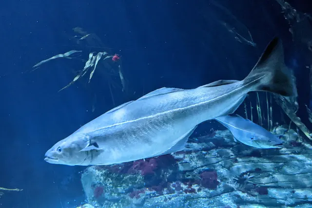 SaitheRegular local target15 placesTynemouth North Pier, Craster and Cullernose Point, Druridge Bay, Whitburn and Souter and 11 moreOver bay, beach, island, pier, river reach, rock markAround Jun–Sept
- DabRegular local target7 placesSeaham, Spittal and Goswick, Horden beach, Tynemouth North Pier and 3 moreOver beach, pier, promenadeAround Jan–Feb, Apr–Sept, Nov–Dec
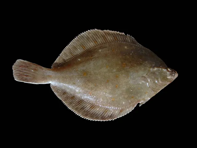 European plaiceRegular local target4 placesSeahouses harbour, South Shields and the Tyne piers, Tynemouth North Pier, Horden beachOver beach, harbour wall, pierAround Apr–Sept
Also documented from the shore: European sea bass · Pollack · Ballan wrasse · Atlantic mackerel · Common sole · Conger eel · Small-spotted catshark · Thornback ray
What these strengths mean
- Regular local target
- Fishing sources describe this as a normal local target here, not merely as caught.
- Seasonal
- Well supported, and concentrated in part of the year rather than spread through it.
- Recorded here
- At least one credible public account of this species being caught here. That is all it means.
- How breadth is counted
- A fish documented at six marks is shown as six marks: breadth never raises the strength on its own. A fishery account describes the fishing; a recorded catch reports one specific catch. How evidence is weighed.
How people fish here
6 methods are recorded on the places documented here, counted from the records themselves rather than from what is practised in the country. Each opens a full guide to the technique.
Ledgering
Recorded at 35 places here, over beach, rock mark, pier, bay.
Fishing a bait on the bottom held by a weight, with no float — the simplest way to fish at distance, in depth, or in wind.
Documented on the same ground: Atlantic cod, Dab, European flounder, European plaice, Saithe, Whiting.
Spinning
Recorded at 16 places here, over rock mark, bay, beach, headland.
Casting an artificial lure and retrieving it so that it moves like something alive — the most direct form of lure fishing.
Documented on the same ground: Atlantic cod, European flounder, Saithe, Atlantic mackerel, Ballan wrasse, Dab.
Float fishing
Recorded at 15 places here, over rock mark, pier, headland, bay.
Suspending a bait at a controlled depth beneath a buoyant indicator — the most visual, most controllable and most widely applicable method in angling.
Documented on the same ground: Atlantic cod, European flounder, European plaice, Saithe, Whiting, Atlantic mackerel.
Surfcasting
Recorded at 10 places here, over beach, rock mark, bay, pier.
Casting heavy baited tackle from a beach into surf — a method defined by distance, by tide, and by reading water that all looks the same.
Documented on the same ground: Atlantic cod, Dab, European flounder, Saithe, European sea bass, Pollack.
Kayak fishing
Recorded at 3 places here, over estuary, bay.
A platform rather than a technique: quiet, shallow-draught access to water no other craft reaches, bought at the price of exposure, and a discipline where the decision not to launch is part of the skill.
Documented on the same ground: European flounder.
Feathering and multi-lure traces
Recorded at 2 places here, over bay, rock mark.
A string of small lures on droppers, worked in the water column — how most people in Britain and Ireland catch their first sea fish, and the method most likely to catch far more than anybody intended.
Documented on the same ground: Atlantic cod, Atlantic mackerel, Ballan wrasse, Pollack, Saithe.
These are the methods documented at the places FishingHQ holds here. A species listed beside a method is documented on the same ground, which is not the same as being taken that way — where a source establishes the method a fish was caught on, it is stated on that place’s own page. All fishing methods.
The fishing year here
The months the records under this area actually name, tightest season first. This is “observed in these months” rather than a season: a species whose months nobody recorded is not listed, because a gap in the evidence is not a year-round fishery.
- WhitingNovember to February
- SaitheJune to September
- European sea bassJune to September
- PollackJune to September
- Ballan wrasseJune to September
- Atlantic mackerelJune to September
- European plaiceApril to September
- Atlantic codSeptember to March
- European flounderJanuary, February, April, May, June, July, August, September, November and December
- DabJanuary, February, April, May, June, July, August, September, November and December
What dominates
Shore ledgering from rock scars and beaches, which is the dominant practice and has a long organised club tradition here. Float fishing and light rock fishing for wrasse, coalfish and pollack over the platforms. Charter and small-boat fishing to offshore wrecks and reefs, which is substantial. Lure fishing for bass at the southern end and for pollack and coalfish over rough ground. Kayak fishing from the sheltered bays and harbours on settled days, constrained by exposure and by cold water. Bait collection on the intertidal scars and estuarine flats.
The water available
Wave-cut rock platforms and drying reefs with kelp, gullies and weed; hard headlands with deep water close in; sand and shingle bays between them; soft eroding glacial and shale cliffs; small harbours with piers and breakwaters; river estuaries entering the sea through industrial and post-industrial ground; and offshore reef, mixed ground and an unusually high density of wrecks.
How the rules are structured
Recreational sea angling in England is not licensed as freshwater angling is, but minimum conservation reference sizes, national bass measures that have changed repeatedly, and byelaws made by the local inshore fisheries and conservation authority all apply, and the byelaws differ between districts along this coast. Several stretches carry conservation designations affecting habitats, access and collection. Harbour authorities set their own rules for fishing from piers and structures, and those rules change. Bait collection on intertidal scars is regulated in places. FishingHQ does not state what any current rule is.
Who to ask
- The relevant Inshore Fisheries and Conservation Authority for the district, which makes and enforces inshore byelaws including those on bait collection.
- The Marine Management Organisation, for national recreational sea fishing measures in English waters.
- The harbour authority or commissioners, for fishing from piers, breakwaters and harbour structures, where permission is a local matter and changes.
- Natural England and the relevant protected site body, where a designation affects access or collection.
- The Maritime and Coastguard Agency and the RNLI, for safety guidance on this coast.
Words you will meet
- Scar
- A flat wave-cut rock platform or reef running out from the shore, exposed at low water. The characteristic ground of this coast: excellent for rough-ground species, expensive in terminal tackle, and accessible only for part of the tide.
- Gully
- A channel cut into a rock platform that retains water as the tide falls and channels it as the tide runs. Fish use gullies to move onto and off the platform, which is why they hold fish disproportionately.
- Snag ground
- Rough bottom that costs tackle. On this coast it is where the fish are, which is why rotten-bottom arrangements and weak links to the lead are standard practice rather than a refinement.
- Coaly
- Coalfish, particularly the small inshore fish that dominate rough-ground and harbour catches. Abundant, willing, and frequently the fish a beginner catches first on this coast.
Conditions and hazards
The rock platforms that make this coast are also what make it dangerous, and the mechanism is being swept rather than falling. A flat scar with an apparently modest sea running is a place where a larger set arrives across ground with no shelter and no high point, and a person on it is standing at sea level with water on three sides. Platforms are weed-covered and extremely slippery, and the gullies that make them fish are trip hazards filling with water. Access to many of them is across or down soft eroding cliff, which is unstable and worse after rain. The tide floods the platform from seaward and from behind through the gullies, so the route back may be cut before the platform itself is covered. Water is cold enough year-round for cold water shock to incapacitate a competent swimmer, and much of this fishing is done at night in winter. Sea fret — dense cold sea fog that arrives quickly on easterly airflow — removes visibility on a coast where the route off a platform depends on seeing it. A buoyancy aid worn, never fishing a platform alone, watching a mark for a full set cycle before committing to it, fixing the exit and the time to leave before starting, and treating a rising sea or arriving fog as a reason to go rather than to move up are what address the actual mechanism.
Rough, clean and mixed: why this coast changes every few hundred metres
The single most useful thing to understand here is that the ground type changes on a scale you can walk, and the ground type decides everything else.
ROUGH GROUND IS ROCK, KELP AND GULLY. It holds cod, coalfish, pollack, wrasse, conger and rockling, and it destroys terminal tackle. It fishes best with a rig designed to be lost cheaply — a weak link to the lead, so a snagged lead breaks away and the rest of the rig and the fish come back. Anybody fishing rough ground without that arrangement is simply losing more.
CLEAN GROUND IS SAND. It holds flatfish, whiting, dab and, in the right conditions, bass and rays, and it takes finer traces and lighter leads. It is fished for distance far more than rough ground is.
MIXED GROUND IS THE INTERESTING ONE. The margin where sand meets rock concentrates food and holds predators from both communities, and on this coast that margin is everywhere because the geology alternates so frequently. Finding it is the skill, and it is done at low water on foot rather than by casting blind.
THE TIDE DECIDES WHICH GROUND YOU CAN USE. Scars dry on a low spring and are covered on a neap high, so a mark may only be fishable for a couple of hours around a particular state of a particular tide. That constraint is much tighter than on a sand coast and is the reason local knowledge here is knowledge about timing rather than about location.
AND THE SWELL DECIDES WHETHER YOU SHOULD. A platform that is workable in a flat sea is not in a metre of swell, and the difference between the two is not visible from the car park. Watching the mark through several wave sets before walking out onto it is the standard local discipline and it exists because people have been killed skipping it.
What experienced anglers do — why, and the sources (4)
Widely and independently recommended by experienced anglers and specialist sources. This is real angling knowledge, not proof: controlled evidence for it is limited, and FishingHQ records it as convention rather than as a demonstrated effect.
- Fishers' Craft and Lettered Art: Tracts on Fishing from the End of the Middle Ages — University of Toronto Press, 1997 (Scientific literature)Relied on for: That fishing traditions develop around the water and fish available to them, and the historical method of reading such traditions.States this directlyCitation checked — the work exists and is described correctly
- General angling website restatements of established technique — Various (Credible secondary source)Relied on for: Widely restated descriptions of regional angling practice, recorded as practitioner consensus rather than as scholarship.Background and mechanism onlyCitation checked — the work exists and is described correctly
- FishBase: a global information system on fishes — Froese, R. and D. Pauly, eds. — FishBase Consortium (Scientific institute)Relied on for: Distribution, habitat association and thermal tolerance of the species named as characteristic of these waters.States this directlyPassage read and verified
- JNCC species and habitat conservation advice — Joint Nature Conservation Committee (Conservation authority)Relied on for: Designation, habitat description and conservation status of the marine and coastal habitats named.States this directlyCitation checked — the work exists and is described correctly
A working coast: harbours, wrecks and an industrial inheritance
The north-east's fishing culture is shaped by the fact that this was a working coast before it was a recreational one, and the inheritance is physical.
THE HARBOURS ARE SMALL, OLD AND NUMEROUS. They were built for commercial fishing and for coal, and most still work in some form. They give shelter, launching, charter access and — where the authority permits it, which is a local and changeable matter — pier and breakwater fishing that is among the most accessible sea angling in Britain. A harbour wall is where a great many people on this coast catch their first fish.
THE WRECK DENSITY OFFSHORE IS EXCEPTIONAL. Heavy shipping, two world wars and a hostile coast have left a great many wrecks within reach of a day boat. Wrecks concentrate cod, ling, coalfish and pollack, and wreck fishing is a distinct discipline here rather than an occasional novelty.
THE INDUSTRIAL DAMAGE WAS REAL AND THE RECOVERY IS RECENT. Colliery spoil was tipped directly onto some beaches for the better part of a century, and those beaches were effectively dead. The recovery since the collieries closed has been substantial and is still in progress, and it is one of the clearest examples in Britain of a coastal ecosystem returning once the pressure stops. An angler fishing those beaches now is fishing ground that was industrial waste within living memory.
AND THE CLUB TRADITION IS STRONG. Organised shore angling — clubs, open competitions, a body of shared local practice — is deeply established here and is a genuine source of knowledge about the coast. It is also practitioner knowledge rather than scientific knowledge, and this page treats it as such.
What experienced anglers do — why, and the sources (2)
Widely and independently recommended by experienced anglers and specialist sources. This is real angling knowledge, not proof: controlled evidence for it is limited, and FishingHQ records it as convention rather than as a demonstrated effect.
- Fishers' Craft and Lettered Art: Tracts on Fishing from the End of the Middle Ages — University of Toronto Press, 1997 (Scientific literature)Relied on for: That fishing traditions develop around the water and fish available to them, and the historical method of reading such traditions.States this directlyCitation checked — the work exists and is described correctly
- General angling website restatements of established technique — Various (Credible secondary source)Relied on for: Widely restated descriptions of regional angling practice, recorded as practitioner consensus rather than as scholarship.Background and mechanism onlyCitation checked — the work exists and is described correctly
The fret is not a fourth hazard, it is what makes the other three lethal
This coast carries the two classic rock-coast dangers, and it carries a third thing that is not really a danger of its own — it is a multiplier that removes the answer to both of the others.
THE FIRST TWO ARE FAMILIAR. A wave-cut scar is flat rock at sea level with water on three sides and no high ground on it, so a bigger set does not give a person somewhere to go; and the same scar floods from the seaward edge and from behind through the gullies at the same time, so the way back closes while the platform is still dry. Both of those are answered by seeing. Watch the sea for a full set cycle before committing. Watch the low ground behind you for water in the gullies. Know where the exit is and look at it.
SEA FRET REMOVES SEEING. Dense cold fog forms over the North Sea and comes in on an easterly airflow, it arrives quickly, and it arrives in otherwise fine settled weather — this is not bad-weather fog, and nothing in the general forecast necessarily announces it. Visibility can go from kilometres to a few metres while a person is standing on rock a few hundred metres from the cliff foot.
AND THEN BOTH ANSWERS ARE GONE AT ONCE. The set cannot be watched for, because it cannot be seen coming. The gully behind cannot be checked, because it cannot be seen filling. And the route off — which on this coast is frequently a specific line across broken rock, up a specific gully, at a specific point — cannot be found by looking for it. A person who was managing three known hazards competently is now managing none of them.
THE FISHERY MAKES THIS WORSE RATHER THAN BETTER. The best of this coast's shore fishing is autumn and winter, much of it at night, a great deal of it on rock, and there is a long organised club tradition of doing exactly that. Night already removes most of the seeing; fret removes the light as well, and a head torch in dense fog illuminates the fog.
WHAT ACTUALLY HELPS is deciding the exit route before the light or the visibility goes, and physically walking it. Note a compass bearing off the platform, or set a waypoint, and carry something that will give it back — a phone with an offline map is enough and a bag left at the cliff foot is not. Treat arriving fog as a reason to leave the platform immediately rather than a reason to wait it out on it, because the tide does not pause while visibility recovers. Wear a buoyancy aid rather than carry one, do not fish a scar alone, and carry the means of calling for help on your person.
AND THE WATER UNDERNEATH ALL OF IT IS COLD IN EVERY MONTH. Immersion in this sea produces an involuntary gasp and loss of breathing control within seconds, which is what decides the outcome rather than any swimming ability afterwards. Check the current inshore waters forecast and the tide before going, and treat a forecast easterly with a warm airmass over cold water as the fret setup that it is.
Official guidance — why, and the sources (3)
Stated by a fisheries authority, scientific institute or recognised angling body. Authoritative, but summarising rather than demonstrating.
- Rock fishing safety and the declared lifejacket areas of New South Wales — NSW Department of Primary Industries and Surf Life Saving NSW (Water-safety or diver-training authority)Relied on for: Rock-platform fishing hazards, the mechanism by which anglers are swept from platforms by sets rather than by average conditions, and the measures that address it including buoyancy aids and observing the sea before committing to a position.States this directlyCitation checked — the work exists and is described correctly
- RNLI water safety guidance: cold water shock and Float to Live — Royal National Lifeboat Institution (Water-safety or diver-training authority)Relied on for: Cold water shock and the immersion response, tidal cut-off, and water-safety guidance for shore anglers and small-craft users.States this directlyPassage read and verified
- Met Office shipping forecast, inshore waters forecast and marine warnings — Met Office, United Kingdom (Government fisheries body)Relied on for: That inshore waters forecasts, sea state, swell and wind are the operative inputs for shore and small-craft decisions, and the spatial resolution at which those forecasts are issued.States this directlyCitation checked — the work exists and is described correctly
Some of what lives here
Fish recorded here that FishingHQ holds a reviewed photograph of. It is not a complete list of what The north-east England coast holds, and it is not a prediction that you will catch any of them — it is a way in to the ones we can show you.
- Atlantic codA large, heavily-built demersal predator of the North Atlantic, and the species whose commercial history is the standard example of stock collapse.
The U.S. Food and Drug Administration, Public domain, via Wikimedia Commons
- SaitheA fast, hard-fighting shoaling gadoid of northern rock and wreck — routinely confused with pollack, and a completely different fish once you know the lateral line.
Wilhelm Thomas Fiege — CC BY-SA 4.0, via Wikimedia Commons
 PollackA fast gadoid that hunts up off reefs and wrecks and takes a lure on the drop — and the sea fish most likely to convert a bait angler to lure fishing.
Wilhelm Thomas Fiege — CC BY-SA 4.0, via Wikimedia Commons
 Ballan wrasseA long-lived rocky-ground resident that begins life female and may change sex — and the species that turned rock marks into a lure fishery.
Diego Delso — CC BY-SA 4.0, via Wikimedia Commons
 Conger eelA very large scaleless eel of wrecks, rock and harbour walls, reaching three metres, and among the most powerful and most genuinely dangerous fish to handle in European seas.
Holger Krisp — CC BY 3.0, via Wikimedia Commons
- European plaiceA right-eyed flatfish with orange spots and a remarkable lifespan, and the representative flatfish for a body plan nothing else on FishingHQ shares.
Hans Hillewaert — CC BY-SA 4.0, via Wikimedia Commons
 Atlantic mackerelA fast, schooling, obligate-swimming pelagic fish that arrives inshore in summer in enormous numbers, and the species most sea anglers catch first.
Hans Hillewaert — CC BY-SA 4.0, via Wikimedia Commons
Places within this area
Publicly documented fishing geography. FishingHQ describes what the ground is; it does not say whether you may fish it, and every one of these sends that question to the body that holds the answer. Browse every place in this part of the world.
Who to ask before fishing any of these
FishingHQ does not know the current access position here. Shore angling in England is not rod-licensed, but access rights, landowner permission, local authority and harbour byelaws, national and inshore fisheries measures, and site designations all apply and all change. Check the current position with the relevant inshore fisheries and conservation authority, the harbour or local authority, and the landowner before going.
FishingHQ does not know the current access position here. Shore angling in England is not rod-licensed, but access rights, landowner permission, local authority and harbour byelaws, national and inshore fisheries measures, and site designations all apply and all change. Check the current position with the relevant inshore fisheries and conservation authority, the harbour or local authority, and the landowner before going. This water is tidal and transitional, so the freshwater regime may also apply above the tidal limit: FishingHQ does not know the current access position here. Freshwater rod fishing in England requires a current rod licence AND separate permission from whoever controls the fishing, which is frequently a club, riparian owner or navigation authority rather than a public body. Close seasons, byelaws and local rules apply and change. Check with the Environment Agency and with the controlling club or owner before going.
Holy Island and the Lindisfarne causeway
Island · Salt water
A low sandstone and dune island separated from the Northumberland mainland by two miles of drying sand and mudflat, with a metalled causeway across it. Hard rock and boulder on the north and east shores, clean sand elsewhere, and vast intertidal flats to the south and west.
The north and east faces take the full North Sea fetch and receive swell from the north and east with no shelter at all. The southern flats are almost entirely sheltered, which is what makes them a nursery and a bird ground rather than a fishery.
Particular to this ground: tides and being cut off, cold water shock.
Severe hazards of The north-east England coast apply here: cliffs and rock platforms.
Particular to this water: This ground carries conservation designations that constrain access, vehicles, bait collection and disturbance independently of any fishing rule.
Tynemouth North Pier
Pier · Salt water
A massive stone breakwater running east from the north side of the Tyne mouth, with a rock and boulder apron along its outer face and dredged deep water in the river entrance inside it.
Fully exposed on the outer face to everything from north through east, and sheltered on the harbour side. The structure exists precisely because this river mouth is dangerous in an easterly, and it takes green water over the top in a heavy sea.
Particular to this ground: cold water shock, slips, trips and falls.
Severe hazards of The north-east England coast apply here: cliffs and rock platforms, tides and being cut off.
Particular to this water: This is an owned and operated structure. Whether angling is allowed on it, when, from where and on what terms is the operator's decision, is frequently seasonal, and changes without notice.
Hartlepool Headland
Headland · Salt water
A limestone promontory projecting east into the North Sea, ringed by rough broken rock, scars and gullies, with small sand beaches tucked either side and a heavily engineered harbour arm to the south.
Exposed from north through south-east. The rock takes swell directly and the ground is genuinely rough — snagging is a feature of the place rather than a misfortune.
Particular to this ground: cliffs and rock platforms, cold water shock.
Severe hazards of The north-east England coast apply here: tides and being cut off.
Bamburgh and Budle Bay
Beach · Salt water
Clean sand beach beneath the dolerite crag the castle stands on, with the Whin Sill outcropping as low reef at either end and the drying sand and mud of Budle Bay behind the northern point.
Severe hazards of The north-east England coast apply here: cliffs and rock platforms, tides and being cut off, cold water shock.
Seahouses harbour
Harbour wall · Salt water
A small working harbour with stone piers over clean sand, sheltered behind the Farne Islands' reef platform which breaks the worst of the swell a mile offshore.
Severe hazards of The north-east England coast apply here: cliffs and rock platforms, tides and being cut off, cold water shock.
Beadnell Bay
Bay · Salt water
A wide crescent of clean sand between two dolerite points, with a limestone reef running out from the southern horn and the only west-facing harbour on the English east coast at its northern end.
Severe hazards of The north-east England coast apply here: cliffs and rock platforms, tides and being cut off, cold water shock.
Craster and Cullernose Point
Rock mark · Salt water
Columnar dolerite of the Whin Sill forming a low cliff and a jointed rock platform, with deep gullies between the columns and kelp over broken ground immediately offshore.
Severe hazards of The north-east England coast apply here: cliffs and rock platforms, tides and being cut off, cold water shock.
Boulmer
Rock mark · Salt water
A low sandstone and limestone scar coast with a shallow rock-fringed haven, weed-covered gullies and clean sand patches between the scars.
Severe hazards of The north-east England coast apply here: cliffs and rock platforms, tides and being cut off, cold water shock.
29 more places in this area
Amble and the Coquet estuary
Estuary · Brackish water
A small piered river mouth over sand and mud, with Coquet Island's low sandstone reef a mile offshore and a drying inner harbour behind the training walls.
Severe hazards of The north-east England coast apply here: cliffs and rock platforms, tides and being cut off, cold water shock.
Druridge Bay
Beach · Salt water
Eleven kilometres of gently shelving clean sand backed by dunes and by the flooded workings of former opencast coal, with no rock anywhere along it and a bar running the length of the surf zone.
Severe hazards of The north-east England coast apply here: cliffs and rock platforms, tides and being cut off, cold water shock.
Newbiggin Bay
Bay · Salt water
A shallow sand bay between two low sandstone points, notable for having been artificially renourished with imported sand and for the offshore breakwater that now shelters it.
Severe hazards of The north-east England coast apply here: cliffs and rock platforms, tides and being cut off, cold water shock.
Blyth South Harbour breakwater
Breakwater · Salt water
A long stone and concrete arm enclosing a working river mouth, with deep dredged water inside and rock armour over clean sand outside.
Severe hazards of The north-east England coast apply here: cliffs and rock platforms, tides and being cut off, cold water shock.
St Mary's Island, Whitley Bay
Island · Salt water
A small limestone island reached by a concrete causeway that covers on the flood, with a wave-cut platform, rock pools and a low reef running north from it.
Particular to this ground: tides and being cut off.
Severe hazards of The north-east England coast apply here: cliffs and rock platforms, cold water shock.
South Shields and the Tyne piers
Pier · Salt water
The southern of the two great stone arms enclosing the Tyne entrance, with dredged deep water in the river mouth inside and rock armour over sand outside.
Severe hazards of The north-east England coast apply here: cliffs and rock platforms, tides and being cut off, cold water shock.
Whitburn and Souter
Rock mark · Salt water
Magnesian limestone cliffs and a broken rock platform with stacks and caves, the hardest ground between the Tyne and the Wear and unusually clear water for this coast.
Severe hazards of The north-east England coast apply here: cliffs and rock platforms, tides and being cut off, cold water shock.
Sunderland Roker Pier
Pier · Salt water
A curving stone breakwater with a lighthouse at its head, enclosing the Wear entrance over mixed sand and rock armour.
Severe hazards of The north-east England coast apply here: cliffs and rock platforms, tides and being cut off, cold water shock.
Seaham
Beach · Salt water
A shingle and sand shore over magnesian limestone, still carrying the coarse black spoil of a century of colliery tipping which gives this coast its distinctive dark beaches and hard bottom.
Severe hazards of The north-east England coast apply here: cliffs and rock platforms, tides and being cut off, cold water shock.
Redcar
Beach · Salt water
A long sand beach interrupted by Redcar Rocks, a hard dolomite scar drying well out at low water, with the Tees estuary and its industrial channel immediately to the west.
Severe hazards of The north-east England coast apply here: cliffs and rock platforms, tides and being cut off, cold water shock.
Saltburn
Beach · Salt water
Sand over a shale platform beneath the highest cliffs on the English east coast, with the pier standing on the transition between the soft Holderness-fed sand to the south-east and the hard Jurassic ground north-west.
Severe hazards of The north-east England coast apply here: cliffs and rock platforms, tides and being cut off, cold water shock.
The Tees estuary
Estuary · Brackish water
A heavily engineered river mouth between training walls, with reclaimed industrial land on both banks, extensive intertidal mud at Seal Sands and one of the most closely monitored water-quality recoveries in England.
Severe hazards of The north-east England coast apply here: cliffs and rock platforms, tides and being cut off, cold water shock.
South Gare
Breakwater · Salt water
A three-kilometre breakwater built of slag from the Teesside furnaces, running north across the Tees mouth with deep dredged channel inside and boulder armour over sand outside.
Severe hazards of The north-east England coast apply here: cliffs and rock platforms, tides and being cut off, cold water shock.
Spittal and Goswick
Beach · Salt water
Sand running south from the Tweed mouth past Spittal to the Goswick flats, with the river's channel at one end and low rock scars showing through the sand along the way. Clean ground with hard patches, and the Tweed colouring it after rain.
Open east and north-east into the North Sea.
Particular to this ground: cold water shock.
Severe hazards of The north-east England coast apply here: cliffs and rock platforms, tides and being cut off.
The Needle's Eye
Rock mark · Salt water
A pierced sandstone stack and the ledges around it on the cliff coast south of Berwick, with deep water below the rock and no beach beneath it. Summer ground: it is a lure mark rather than a bait one.
Open east into the North Sea from a cliff coast.
Particular to this ground: cliffs and rock platforms, cold water shock.
Severe hazards of The north-east England coast apply here: tides and being cut off.
North Sunderland Point
Headland · Salt water
The whinstone point north of Seahouses harbour, with hard dolerite ledges stepping into deep water and the Farne Islands offshore. Rough ground and the tidal stream between the shore and the islands running past it.
Open east and north-east, with the Farnes breaking the worst of it.
Particular to this ground: cliffs and rock platforms, cold water shock.
Severe hazards of The north-east England coast apply here: tides and being cut off.
Embleton Bay
Bay · Salt water
A crescent of clean sand between the Dunstanburgh whinstone at its south end and Newton Point at its north, with reef running out from both horns and dune behind. Sand in the middle, hard rock at the ends.
Open east and north-east into the North Sea.
Particular to this ground: cold water shock.
Severe hazards of The north-east England coast apply here: cliffs and rock platforms, tides and being cut off.
Dunstanburgh Castle rocks
Rock mark · Salt water
The whinstone sill the castle stands on, with columnar dolerite dropping straight into deep water below the walls and boulder ground at its foot. A mile's walk from either end and no shelter on it.
Fully open east and north-east; the sill takes the sea head-on.
Particular to this ground: cliffs and rock platforms, cold water shock.
Severe hazards of The north-east England coast apply here: tides and being cut off.
Cresswell Carrs
Rock mark · Salt water
Low rock scars — carrs — running out from the shore at the north end of Druridge Bay, with clean sand between them that holds razorfish. Rougher and heavier ground to the north; the razor beds are the reason a storm improves it.
Open east and north-east with nothing in front of it.
Particular to this ground: cliffs and rock platforms, tides and being cut off, cold water shock.
Snab Point
Headland · Salt water
A low rock point at the south end of the Cresswell scars, with broken ground off it and the sand of Druridge Bay running north. The corner that separates the rough ground from the beach.
Open east into the North Sea.
Particular to this ground: cliffs and rock platforms.
Severe hazards of The north-east England coast apply here: tides and being cut off, cold water shock.
The tidal Tyne
River reach · Brackish water
The dredged tidal river from the Newcastle quaysides down through Hebburn and Jarrow to the piers, with hard quay walls, old staith timbers and rubble along both banks and a deep central channel. Urban river ground: structure everywhere and no beach anywhere.
Sheltered the whole length of it; the weather that matters is what the river is doing.
Particular to this ground: cold water shock.
Severe hazards of The north-east England coast apply here: cliffs and rock platforms, tides and being cut off.
Marsden Bay and Camel Island
Bay · Salt water
A magnesian limestone bay of stacks, arches and caves below high cliffs, with sand between the rock and Camel Island standing off the shore at its north end. Hard white rock and clean sand in the same bay.
Open east into the North Sea below cliffs.
Particular to this ground: cliffs and rock platforms, tides and being cut off, cold water shock.
Hendon promenade
Promenade · Salt water
The sea wall and promenade south of Sunderland docks, over a foreshore of sand with limestone rubble and old ballast at the wall's foot. Hard standing on a shore that is otherwise beach.
Open east into the North Sea.
Severe hazards of The north-east England coast apply here: cliffs and rock platforms, tides and being cut off, cold water shock.
The Ryhope marks
Rock mark · Salt water
Limestone scars and the old colliery rubble below the Ryhope denes, with named ledges — the Target, the Manholes — separated by gullies of sand. Rough ground made rougher by what the pit put on it.
Open east into the North Sea.
Particular to this ground: cliffs and rock platforms, cold water shock.
Severe hazards of The north-east England coast apply here: tides and being cut off.
Chemical Beach and the Stack
Beach · Salt water
A beach of sea-coal, limestone shingle and industrial waste south of Seaham, with a limestone stack standing off it and hard scars under the sand. The name is literal: this shore was built by what the works and the pits tipped over the cliff.
Open east into the North Sea.
Particular to this ground: cliffs and rock platforms, cold water shock.
Severe hazards of The north-east England coast apply here: tides and being cut off.
Horden beach
Beach · Salt water
A Durham colliery beach of black sand and sea-coal below the denes, gradually cleaning since the pits shut, with limestone scars showing through at low water. Steeper than it looks and holding more hard ground than the sand suggests.
Open east into the North Sea.
Particular to this ground: cold water shock.
Severe hazards of The north-east England coast apply here: cliffs and rock platforms, tides and being cut off.
Crimdon beach
Beach · Salt water
Sand and dune at the Crimdon Dene mouth, running south towards Hartlepool, with a little burn cutting the beach and cleaner sand than the colliery shore north of it. Open, uniform ground with a stream through it.
Open east into the North Sea.
Severe hazards of The north-east England coast apply here: cliffs and rock platforms, tides and being cut off, cold water shock.
Steetley Pier and Parton
Pier · Salt water
The skeleton of the old magnesite works pier north of Hartlepool, standing off a shore of limestone scar and shingle. A ruin rather than a structure to walk out on, and the ground around its legs is what is fished.
Open east and north-east into the North Sea.
Particular to this ground: cold water shock, slips, trips and falls.
Severe hazards of The north-east England coast apply here: cliffs and rock platforms, tides and being cut off.
Seaton Carew
Beach · Salt water
A long flat sand beach between Hartlepool and the Tees mouth, backed by a promenade and dune, with the Tees channel and the works of Teesport at its southern end. Clean uniform sand with the estuary's influence at one end of it.
Open east into the North Sea.
Severe hazards of The north-east England coast apply here: cliffs and rock platforms, tides and being cut off, cold water shock.
Safety
Cliffs and rock platforms — Can cause serious injury or death
A wave-cut platform gives an angler nowhere to go. A larger set arrives across flat weed-covered rock at sea level, with water on three sides, and a person knocked down slides on kelp into a gully or off the edge into cold water. Sets are irregular and a platform that has been dry for twenty minutes is not evidence about the next wave.
What reduces it: Watch the mark through several full wave-set cycles before walking out onto it. Wear a buoyancy aid. Do not fish a platform alone. Fix the exit and the time to leave before starting, and treat a rising sea as a reason to leave rather than to move back a few metres.
Worse when:
- Long-period ground swell arriving with little local wind, which produces far larger sets than the conditions suggest.
- Wet kelp, which offers effectively no grip.
- Darkness, when a set cannot be seen coming.
Tides and being cut off — Can cause serious injury or death
Scars flood from seaward and simultaneously from behind, as water rises through the gullies that cut them. The route back to the shore may be under water while the platform is still dry, which is the reverse of what somebody watching the sea in front of them expects.
What reduces it: Work out the return route and the time it is lost before going out, not after. Set a leaving time against the tide rather than against the fishing, and treat rising water in a gully behind you as the signal to go immediately.
Cold water shock — Can cause serious injury or death
North Sea water on this coast is cold year-round, and immersion produces an involuntary gasp and loss of breathing control within seconds. Much of the fishing is winter night fishing from rock, alone.
What reduces it: A buoyancy aid worn rather than carried, not fishing alone, a means of calling for help carried on the person, and telling somebody the mark and the return time.
Weather and lightning — Can cause injury needing treatment
Sea fret — dense cold sea fog carried in on easterly airflow — arrives quickly and removes visibility on a coast where getting off a platform depends on seeing the route. It can form in otherwise fine settled weather.
What reduces it: Treat arriving fog as a reason to leave a platform immediately rather than to wait it out. Carry a light and a compass or a phone with an offline map, and know the exit bearing before visibility goes.
Precautions that always apply here
- Wear a buoyancy aid or lifejacket. Cold water incapacitates strong swimmers within a minute, long before swimming ability matters.
- Check the tide before you go and know your exit route. Being cut off is the commonest way a shore session becomes a rescue.
- Tell somebody where you are going and when you expect to be back.
- Carry a charged phone in a waterproof case, or another means of calling for help.
Further safety reading
- Rock platform and cliff safety — A wave-cut platform gives an angler nowhere to go: a larger set arrives across flat weed-covered rock at sea level with water on three sides. Watching a mark through several full set cycles before committing to it is the standing local discipline, and it exists because people have been killed skipping it.
- Tides and being cut off — Scars flood from seaward and simultaneously from behind through the gullies that cut them, so the route back may be under water while the platform is still dry — the reverse of what somebody watching the sea in front of them expects.
Check the rules before you fish
Fishing laws, bylaws, access rules, seasons, bait restrictions and permitted methods vary by location and can change. Check the current rules from the relevant authority and the water you intend to fish before fishing.
Check with:
- Current national or regional law for where you are fishing
- Current local bylaws
- The relevant fisheries authority
- The landowner, club or fishery whose water it is
- Any restrictions specific to the species or the method you intend to use
Where to go next
What swims here
- Atlantic codThe species this coast's shore fishing was built around, associated with the rock scars, kelp gullies and mixed ground rather than with clean sand. The fishery is substantially reduced from its historical level and anglers who fished it decades ago are describing a genuinely different one.
- Atlantic mackerelA summer visitor to this coast, taken from piers, platforms and boats when water temperature brings shoals inshore. Availability is a temperature and bait question rather than a calendar one.
- Ballan wrasseA resident of the kelp-covered wave-cut platforms and boulder ground, strongly associated with the gullies that cut them and largely absent from the clean sand bays between.
- Conger eelAssociated with the broken rock of the scars, harbour structure and the unusually high density of offshore wrecks on this coast.
- European plaiceOccupies the clean sand of the bays between the rock outcrops, which is the other half of a coast whose ground alternates over short distances.
- PollackAssociated with the kelp and reef of the rock platforms and with offshore wreck and rough ground, holding in and above structure rather than on clean bottom.
- SaitheAbundant over the rough ground, harbours and piers of this coast, and frequently the first fish anybody catches here. Small inshore fish dominate the shore catch.
Local knowledge
How this compares
- The Moray FirthTwo cold North Sea coasts of hard rock and small harbours with near-identical shore practice, separated by the presence or absence of major salmon rivers — which is what turns one into a migratory corridor with its own regulatory layer and leaves the other a pure sea fishery.
- The Yorkshire coastThe two halves of the English North Sea rock coast. North-east England is hard rock throughout; Yorkshire is hard rock only until the chalk headland, and then it is not rock at all. Reading them together shows what the headland actually does.
Sources and evidence
- Cefas science, advice and data on marine and freshwater environments — Centre for Environment, Fisheries and Aquaculture Science (Government fisheries body)Relied on for: Marine environmental science for UK shelf seas, including the physical characterisation of sediment, coastal process and the monitoring programmes that describe them.States this directlyCitation checked — the work exists and is described correctly
- ICES Advice on fishing opportunities, catch and effort — International Council for the Exploration of the Sea (Scientific institute)Relied on for: Ecoregion description, stock distribution and the hydrography of the sea areas assessed.States this directlyCitation checked — the work exists and is described correctly
- FishBase: a global information system on fishes — Froese, R. and D. Pauly, eds. — FishBase Consortium (Scientific institute)Relied on for: Distribution, habitat association and thermal tolerance of the species named as characteristic of these waters.States this directlyPassage read and verified
- JNCC species and habitat conservation advice — Joint Nature Conservation Committee (Conservation authority)Relied on for: Designation, habitat description and conservation status of the marine and coastal habitats named.States this directlyCitation checked — the work exists and is described correctly
- Fishers' Craft and Lettered Art: Tracts on Fishing from the End of the Middle Ages — University of Toronto Press, 1997 (Scientific literature)Relied on for: That fishing traditions develop around the water and fish available to them, and the historical method of reading such traditions.States this directlyCitation checked — the work exists and is described correctly
- General angling website restatements of established technique — Various (Credible secondary source)Relied on for: Widely restated descriptions of regional angling practice, recorded as practitioner consensus rather than as scholarship.Background and mechanism onlyCitation checked — the work exists and is described correctly
Why the 13 connections on this page are here, and the sources
What swims here
Backed by research — 7 connections
Supported by peer-reviewed research or fisheries science. The sources are listed and can be checked.
Atlantic cod
A claim that a place contains the ground and conditions the species is associated with. It is a distributional statement about the world, it rests on the regional reference literature, and it deliberately asserts nothing about access, permission or catch.
- The Fishes of the British Isles and North-West Europe — Macmillan, 1969 (Reference work)Relied on for: Distribution and habitat association of the marine and estuarine fishes of the British Isles, including which coasts and ground types a species occupies.States this directlyCitation checked — the work exists and is described correctly
- FishBase: a global information system on fishes — Froese, R. and D. Pauly, eds. — FishBase Consortium (Scientific institute)Relied on for: Recorded distribution, depth range and habitat association for the species named.States this directlyPassage read and verified
Atlantic mackerel
A claim that a place contains the ground and conditions the species is associated with. It is a distributional statement about the world, it rests on the regional reference literature, and it deliberately asserts nothing about access, permission or catch.
- The Fishes of the British Isles and North-West Europe — Macmillan, 1969 (Reference work)Relied on for: Distribution and habitat association of the marine and estuarine fishes of the British Isles, including which coasts and ground types a species occupies.States this directlyCitation checked — the work exists and is described correctly
- FishBase: a global information system on fishes — Froese, R. and D. Pauly, eds. — FishBase Consortium (Scientific institute)Relied on for: Recorded distribution, depth range and habitat association for the species named.States this directlyPassage read and verified
Ballan wrasse
A claim that a place contains the ground and conditions the species is associated with. It is a distributional statement about the world, it rests on the regional reference literature, and it deliberately asserts nothing about access, permission or catch.
- The Fishes of the British Isles and North-West Europe — Macmillan, 1969 (Reference work)Relied on for: Distribution and habitat association of the marine and estuarine fishes of the British Isles, including which coasts and ground types a species occupies.States this directlyCitation checked — the work exists and is described correctly
- FishBase: a global information system on fishes — Froese, R. and D. Pauly, eds. — FishBase Consortium (Scientific institute)Relied on for: Recorded distribution, depth range and habitat association for the species named.States this directlyPassage read and verified
Conger eel
A claim that a place contains the ground and conditions the species is associated with. It is a distributional statement about the world, it rests on the regional reference literature, and it deliberately asserts nothing about access, permission or catch.
- The Fishes of the British Isles and North-West Europe — Macmillan, 1969 (Reference work)Relied on for: Distribution and habitat association of the marine and estuarine fishes of the British Isles, including which coasts and ground types a species occupies.States this directlyCitation checked — the work exists and is described correctly
- FishBase: a global information system on fishes — Froese, R. and D. Pauly, eds. — FishBase Consortium (Scientific institute)Relied on for: Recorded distribution, depth range and habitat association for the species named.States this directlyPassage read and verified
European plaice
A claim that a place contains the ground and conditions the species is associated with. It is a distributional statement about the world, it rests on the regional reference literature, and it deliberately asserts nothing about access, permission or catch.
- The Fishes of the British Isles and North-West Europe — Macmillan, 1969 (Reference work)Relied on for: Distribution and habitat association of the marine and estuarine fishes of the British Isles, including which coasts and ground types a species occupies.States this directlyCitation checked — the work exists and is described correctly
- FishBase: a global information system on fishes — Froese, R. and D. Pauly, eds. — FishBase Consortium (Scientific institute)Relied on for: Recorded distribution, depth range and habitat association for the species named.States this directlyPassage read and verified
Pollack
A claim that a place contains the ground and conditions the species is associated with. It is a distributional statement about the world, it rests on the regional reference literature, and it deliberately asserts nothing about access, permission or catch.
- The Fishes of the British Isles and North-West Europe — Macmillan, 1969 (Reference work)Relied on for: Distribution and habitat association of the marine and estuarine fishes of the British Isles, including which coasts and ground types a species occupies.States this directlyCitation checked — the work exists and is described correctly
- FishBase: a global information system on fishes — Froese, R. and D. Pauly, eds. — FishBase Consortium (Scientific institute)Relied on for: Recorded distribution, depth range and habitat association for the species named.States this directlyPassage read and verified
Saithe
A claim that a place contains the ground and conditions the species is associated with. It is a distributional statement about the world, it rests on the regional reference literature, and it deliberately asserts nothing about access, permission or catch.
- The Fishes of the British Isles and North-West Europe — Macmillan, 1969 (Reference work)Relied on for: Distribution and habitat association of the marine and estuarine fishes of the British Isles, including which coasts and ground types a species occupies.States this directlyCitation checked — the work exists and is described correctly
- FishBase: a global information system on fishes — Froese, R. and D. Pauly, eds. — FishBase Consortium (Scientific institute)Relied on for: Recorded distribution, depth range and habitat association for the species named.States this directlyPassage read and verified
How people fish here
What experienced anglers do — 1 connection
Widely and independently recommended by experienced anglers and specialist sources. This is real angling knowledge, not proof: controlled evidence for it is limited, and FishingHQ records it as convention rather than as a demonstrated effect.
Sea fishing
A statement about which body of practice dominates in a place, established across a periodical tradition and a historical one rather than measured.
- Sea Angler — Bauer Media (Specialist angling publication)Relied on for: Long-running periodical coverage of British and Irish shore and boat angling, including which disciplines dominate on which coasts.States this directlyCitation checked — the work exists and is described correctly
- Fishers' Craft and Lettered Art: Tracts on Fishing from the End of the Middle Ages — University of Toronto Press, 1997 (Scientific literature)Relied on for: That fishing traditions develop around the water and fish available to them, and the method of reading such traditions.States this directlyCitation checked — the work exists and is described correctly
Local knowledge
Backed by research — 1 connection
Supported by peer-reviewed research or fisheries science. The sources are listed and can be checked.
Reading the tide
A link from a place to the physical mechanism that governs its fishing, which is a claim about coastal process or hydrography rather than about angling.
- ICES Advice on fishing opportunities, catch and effort — International Council for the Exploration of the Sea (Scientific institute)Relied on for: Ecoregion description, stock distribution and the hydrography of the sea areas named, including seasonal inshore movement.States this directlyCitation checked — the work exists and is described correctly
- Cefas science, advice and data on marine and freshwater environments — Centre for Environment, Fisheries and Aquaculture Science (Government fisheries body)Relied on for: Marine environmental science for UK shelf seas, including sediment character, coastal process and inshore monitoring.States this directlyCitation checked — the work exists and is described correctly
How this compares
What experienced anglers do — 2 connections
Widely and independently recommended by experienced anglers and specialist sources. This is real angling knowledge, not proof: controlled evidence for it is limited, and FishingHQ records it as convention rather than as a demonstrated effect.
The Moray Firth
A claim that two places are worth reading against one another, because a reader choosing between them or generalising from one to the other needs to know how the underlying process differs.
- General angling website restatements of established technique — Various (Credible secondary source)Relied on for: Widely restated descriptions of which practices are conventionally used in the waters named, recorded as practitioner consensus rather than as scholarship.Background and mechanism onlyCitation checked — the work exists and is described correctly
- Sea Angler — Bauer Media (Specialist angling publication)Relied on for: Long-running published description of British and Irish sea angling practice by region and by ground type.FishingHQ's interpretation of what it saysCitation checked — the work exists and is described correctly
The Yorkshire coast
A claim that two places are worth reading against one another, because a reader choosing between them or generalising from one to the other needs to know how the underlying process differs.
- General angling website restatements of established technique — Various (Credible secondary source)Relied on for: Widely restated descriptions of which practices are conventionally used in the waters named, recorded as practitioner consensus rather than as scholarship.Background and mechanism onlyCitation checked — the work exists and is described correctly
- Sea Angler — Bauer Media (Specialist angling publication)Relied on for: Long-running published description of British sea angling practice by region and by ground type.FishingHQ's interpretation of what it saysCitation checked — the work exists and is described correctly
Safety reading
Official guidance — 2 connections
Stated by a fisheries authority, scientific institute or recognised angling body. Authoritative, but summarising rather than demonstrating.
Rock platform and cliff safety
A statement that a place presents a particular hazard, resting on water-safety guidance issued by bodies with responsibility for it rather than on angling practice.
- RNLI water safety guidance: cold water shock and Float to Live — Royal National Lifeboat Institution (Water-safety or diver-training authority)Relied on for: Cold water shock, immersion response, tidal cut-off and water-safety guidance for shore anglers and small-craft users.States this directlyPassage read and verified
- Rock fishing safety and the declared lifejacket areas of New South Wales — NSW Department of Primary Industries and Surf Life Saving NSW (Water-safety or diver-training authority)Relied on for: Rock-platform hazards, the mechanism by which anglers are swept, and the measures that address it.States this directlyCitation checked — the work exists and is described correctly
Tides and being cut off
A statement that a place presents a particular hazard, resting on water-safety guidance issued by bodies with responsibility for it rather than on angling practice.
- RNLI water safety guidance: cold water shock and Float to Live — Royal National Lifeboat Institution (Water-safety or diver-training authority)Relied on for: Cold water shock, immersion response, tidal cut-off and water-safety guidance for shore anglers and small-craft users.States this directlyPassage read and verified
- Rock fishing safety and the declared lifejacket areas of New South Wales — NSW Department of Primary Industries and Surf Life Saving NSW (Water-safety or diver-training authority)Relied on for: Rock-platform hazards, the mechanism by which anglers are swept, and the measures that address it.States this directlyCitation checked — the work exists and is described correctly
How FishingHQ labels evidence is explained in the evidence policy.