Amble and the Coquet estuary
Estuary · Brackish water · in The north-east England coast
A small piered river mouth over sand and mud, with Coquet Island's low sandstone reef a mile offshore and a drying inner harbour behind the training walls.
Safety: cliffs and rock platforms — can cause serious injury or death. 2 more points apply here.
FishingHQ describes what this place is, not whether you may fish it. Access, permits and who to ask.
What you can catch here
Documented at this place, grouped by how you would be fishing, with how strongly the sources support each one. This is what has been written down, not a forecast, and being listed is never permission to fish.
From the shore · 3
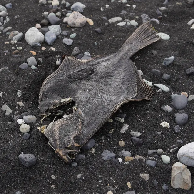 European flounderRegular local target1 placeAmble and the Coquet estuaryOver estuary
Photo: nbasargin, via iNaturalist, CC BY; resized and trimmed to fit
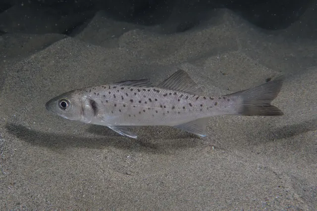 European sea bassRecorded here1 placeAmble and the Coquet estuaryOver estuary
Photo: Julien Renoult, via Wikimedia Commons, CC BY 4.0; resized and trimmed to fit
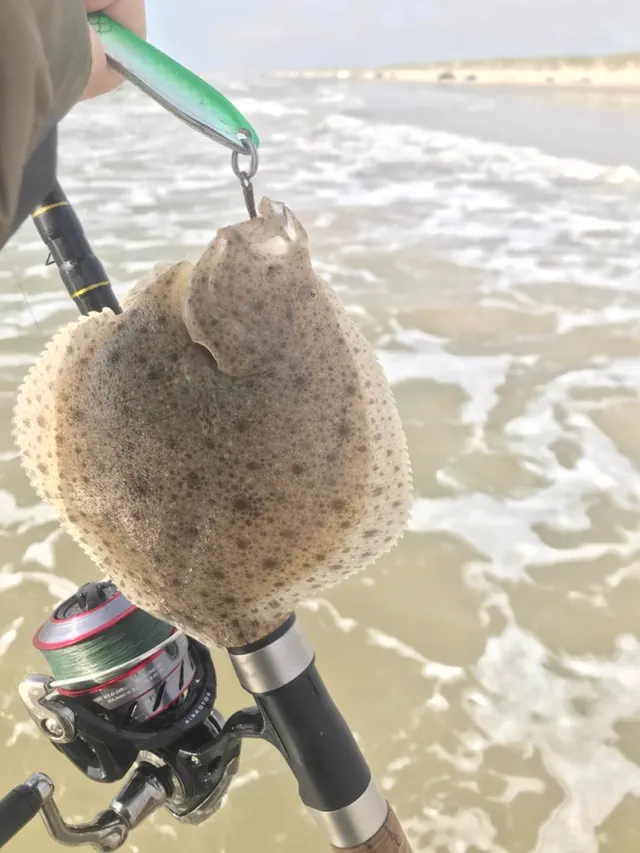 TurbotRecorded here1 placeAmble and the Coquet estuaryOver estuary
Photo: Jonas Holm Hald Therkildsen, via iNaturalist, CC0 1.0; resized and trimmed to fit

What these strengths mean
- Regular local target
- Fishing sources describe this as a normal local target here, not merely as caught.
- Recorded here
- At least one credible public account of this species being caught here. That is all it means.
- How breadth is counted
- A fish documented at six marks is shown as six marks: breadth never raises the strength on its own. A fishery account describes the fishing; a recorded catch reports one specific catch. How evidence is weighed.
Also associated with this ground
Recorded as present here without a documented method or strength behind them.
Recorded here, but not a species to target
These are recorded here, but they are not fish to take. Each is either assessed as Critically Endangered or protected by statute in this jurisdiction, and taking one may be prohibited outright — elsewhere every rod-caught fish must be returned. Read the species page and check the current rules with the authority before fishing.
Fish documented nearby, not here
Nothing below has been documented at Amble and the Coquet estuary itself. Each one has been documented at a named place on the same ground, and the places are listed with it. Treat this as what the water around here holds rather than as a catch list for this mark.
Widely documented on this ground
Documented at three or more neighbouring places, fished a way this place is also fished. That is a pattern about the ground rather than about any one mark, and it is the closest this site comes to saying you will probably meet a fish somewhere nothing has been written about.
From the shore
- Atlantic cod — documented at Tynemouth North Pier; Seahouses harbour; Craster and Cullernose Point (+19 more)
- Whiting — documented at Newbiggin Bay; Blyth South Harbour breakwater; South Shields and the Tyne piers (+11 more)
- Saithe — documented at Tynemouth North Pier; Craster and Cullernose Point; Druridge Bay (+10 more)
- Dab — documented at Seaham; Spittal and Goswick; Tynemouth North Pier (+2 more)
- European plaice — documented at Seahouses harbour; South Shields and the Tyne piers; Tynemouth North Pier
- Pollack — documented at Craster and Cullernose Point; Spittal and Goswick; The Needle's Eye (+7 more)
- Atlantic mackerel — documented at Craster and Cullernose Point; Embleton Bay; Dunstanburgh Castle rocks (+1 more)
- Ballan wrasse — documented at Craster and Cullernose Point; North Sunderland Point; Embleton Bay (+1 more)
Also documented at neighbouring places
One or two accounts each, on the ground around here. Enough to know the fish is caught in these waters; not enough to say anything about this place.
From the shore
- Common sole — documented at Tynemouth North Pier
- Conger eel — documented at Craster and Cullernose Point
Also named for this place
A guide to this coast names these fish in its own entry for Amble and the Coquet estuary. They are recorded against the coast's account, with the entry's words kept as the evidence, and are not yet part of this place's own profile above.
Caught in this area
Documented being caught in this area, without being described as something people set out for.
- Atlantic cod — from the shore · December to February · named for this place by the source
- Atlantic mackerel — from the shore · June to August · named for this place by the source
- Dab — from the shore · Amble and the Coquet estuary, South Shields and the Tyne piers, Whitburn and Souter, Sunderland Roker Pier, South Gare only · named for this place by the source
- Whiting — from the shore · December to February · named for this place by the source
Where this comes from
- Atlantic cod — caught in this area. Documented being caught in this area by 2 sources, without being described as a main target.
- British Sea Fishing: north-east England and Yorkshire shore marks — British Sea Fishing
- British Sea Fishing: north-east England shore marks, read entry by entry — British Sea Fishing
- Atlantic mackerel — caught in this area. Documented being caught in this area by 2 sources, without being described as a main target.
- British Sea Fishing: north-east England and Yorkshire shore marks — British Sea Fishing
- British Sea Fishing: north-east England shore marks, read entry by entry — British Sea Fishing
- Dab — caught in this area. Documented being caught in this area by 1 source, without being described as a main target.
- British Sea Fishing: north-east England shore marks, read entry by entry — British Sea Fishing
- Whiting — caught in this area. Documented being caught in this area by 3 sources, without being described as a main target.
- British Sea Fishing: north-east England and Yorkshire shore marks — British Sea Fishing
- British Sea Fishing: the ray, smooth-hound, whiting and flatfish entries — British Sea Fishing
- British Sea Fishing: north-east England shore marks, read entry by entry — British Sea Fishing
None of this says you may fish anywhere or take anything: licences, protected species, minimum sizes and closed areas are set by the local authority. How evidence is weighed.
How people fish it
Practised here: Sea fishing.
Methods the sources name for this ground. Each one is explained in full on its own page.
Kayak fishing is the exception: it is listed for this ground and no kayak source has been read for it. Take it as somewhere a kayak might be used, not as something a source reports.
- Ledgering
Fishing a bait on the bottom held by a weight, with no float — the simplest way to fish at distance, in depth, or in wind.
- Spinning
Casting an artificial lure and retrieving it so that it moves like something alive — the most direct form of lure fishing.
- Kayak fishing
A platform rather than a technique: quiet, shallow-draught access to water no other craft reaches, bought at the price of exposure, and a discipline where the decision not to launch is part of the skill.
Baits and lures for these fish
The baits and lures each of the fish above is commonly taken on, from that fish’s own page. This is what works for the fish, not a report of what people use on this particular water — local knowledge and the conditions on the day still decide.
Baits
- Peeler crab — for European flounder, European sea bass
- Ragworm — for European flounder, European sea bass
- Sand eel — for European sea bass, Turbot
- Crab and shellfish — for European sea bass
- Fish strip and cut bait — for Turbot
Lures
- Jerkbaits — for European sea bass
- Metal jigs — for European sea bass
- Soft plastics — for European sea bass
- Streamers — for European sea bass
- Surface lures — for European sea bass
How to catch them: Flounder fishing · Bass fishing
The ground and the water
- The ground
- A small piered river mouth over sand and mud, with Coquet Island's low sandstone reef a mile offshore and a drying inner harbour behind the training walls.
Safety
Cliffs and rock platforms — Can cause serious injury or death
A wave-cut platform gives an angler nowhere to go. A larger set arrives across flat weed-covered rock at sea level, with water on three sides, and a person knocked down slides on kelp into a gully or off the edge into cold water. Sets are irregular and a platform that has been dry for twenty minutes is not evidence about the next wave.
What reduces it: Watch the mark through several full wave-set cycles before walking out onto it. Wear a buoyancy aid. Do not fish a platform alone. Fix the exit and the time to leave before starting, and treat a rising sea as a reason to leave rather than to move back a few metres.
Worse when:
- Long-period ground swell arriving with little local wind, which produces far larger sets than the conditions suggest.
- Wet kelp, which offers effectively no grip.
- Darkness, when a set cannot be seen coming.
Tides and being cut off — Can cause serious injury or death
Scars flood from seaward and simultaneously from behind, as water rises through the gullies that cut them. The route back to the shore may be under water while the platform is still dry, which is the reverse of what somebody watching the sea in front of them expects.
What reduces it: Work out the return route and the time it is lost before going out, not after. Set a leaving time against the tide rather than against the fishing, and treat rising water in a gully behind you as the signal to go immediately.
Cold water shock — Can cause serious injury or death
North Sea water on this coast is cold year-round, and immersion produces an involuntary gasp and loss of breathing control within seconds. Much of the fishing is winter night fishing from rock, alone.
What reduces it: A buoyancy aid worn rather than carried, not fishing alone, a means of calling for help carried on the person, and telling somebody the mark and the return time.
Rules and access
FishingHQ does not know the current access position here. Shore angling in England is not rod-licensed, but access rights, landowner permission, local authority and harbour byelaws, national and inshore fisheries measures, and site designations all apply and all change. Check the current position with the relevant inshore fisheries and conservation authority, the harbour or local authority, and the landowner before going. This water is tidal and transitional, so the freshwater regime may also apply above the tidal limit: FishingHQ does not know the current access position here. Freshwater rod fishing in England requires a current rod licence AND separate permission from whoever controls the fishing, which is frequently a club, riparian owner or navigation authority rather than a public body. Close seasons, byelaws and local rules apply and change. Check with the Environment Agency and with the controlling club or owner before going.
Who holds the answer:
- The Inshore Fisheries and Conservation Authority for the district, which makes and enforces inshore byelaws.
- The Marine Management Organisation, for national recreational sea fishing measures in English waters.
- The local authority and, where one exists, the harbour authority, for access, byelaws and shellfish classification.
- The Environment Agency, for rod licensing, close seasons and fisheries byelaws in England.
- The club, association, riparian owner or navigation authority that controls the fishing.
- The relevant Inshore Fisheries and Conservation Authority for the district, which makes and enforces inshore byelaws including those on bait collection.
- The harbour authority or commissioners, for fishing from piers, breakwaters and harbour structures, where permission is a local matter and changes.
- Natural England and the relevant protected site body, where a designation affects access or collection.
- The Maritime and Coastguard Agency and the RNLI, for safety guidance on this coast.
Nearby fishing
Other publicly documented places within about 40 km, by distance. Positions are approximate public geography and are never exact marks.
- Druridge Bay — 5–10 km · Beach
- Boulmer — 5–10 km · Rock mark
- Cresswell Carrs — 10–25 km · Rock mark
- Snab Point — 10–25 km · Headland
- Craster and Cullernose Point — 10–25 km · Rock mark
- Dunstanburgh Castle rocks — 10–25 km · Rock mark
- Newbiggin Bay — 10–25 km · Bay
- Embleton Bay — 10–25 km · Bay
Sources for this place
- JNCC species and habitat conservation advice — Joint Nature Conservation Committee (Conservation authority)Relied on for: Description, designation and habitat characterisation of the named coastal and marine features of the United Kingdom, and the species characteristically associated with them.States this directlyCitation checked — the work exists and is described correctly
- Cefas science, advice and data on marine and freshwater environments — Centre for Environment, Fisheries and Aquaculture Science (Government fisheries body)Relied on for: Marine environmental science for UK shelf seas: sediment characterisation, estuarine process, shellfish bed distribution, tidal range and the monitoring that describes them.States this directlyCitation checked — the work exists and is described correctly
- Sea Angler — Bauer Media (Specialist angling publication)Relied on for: Long-running published description of British sea angling practice by region, ground type and named mark.FishingHQ's interpretation of what it saysCitation checked — the work exists and is described correctly
- General angling website restatements of established technique — Various (Credible secondary source)Relied on for: Widely restated public descriptions of which places are conventionally fished and how, recorded as practitioner consensus rather than as scholarship, and not relied on for access, permission or any current rule.Background and mechanism onlyCitation checked — the work exists and is described correctly
- British Sea Fishing: north-east England and Yorkshire shore marks — British Sea Fishing (Credible secondary source)Relied on for: The shore species the guide's own entry for this mark names, with the seasons, baits and methods it gives for them.States this directlyPassage read and verified
How FishingHQ labels evidence is explained in the evidence policy. Last reviewed 2026-08-16.