Cardigan Bay and the sarnau
Fishing regions · Last reviewed 2026-08-16
A great open bay in the west of Wales with glacial moraine reefs running kilometres out to sea and drying at low water — a ground type with no analogue anywhere else in these islands — and the largest bottlenose dolphin population in Britain.
Safety: boat safety — can cause serious injury or death. 3 more points apply here.
Being listed here is not permission to fish. What that meansClose
Access, fishing rights, seasons, licences, local bylaws and permitted methods vary and can change. Check current access, permission, local regulations, closures and restrictions before you travel or fish. FishingHQ describes what the ground is and names who holds the answer; it does not hold the answer itself.
Find the authority for a jurisdiction · What FishingHQ does and does not cover
Cardigan Bay is the enormous westward-facing bight between the Llŷn peninsula in the north and Pembrokeshire in the south, and it had no record on FishingHQ despite being roughly 150 km of coast and one of the most distinctive pieces of sea ground in Britain.
THE SARNAU ARE THE REASON THIS PAGE EXISTS. Three long ridges of boulder and cobble run from the coast out into the bay — Sarn Badrig the largest, extending many kilometres — standing proud of the seabed and drying at their inshore ends on the biggest low tides. They are glacial moraines: the debris dumped along the flanks of ice streams that flowed down this coast, left standing when the ice melted and the sea rose around them.
NOTHING ELSE IN BRITAIN OR IRELAND IS BUILT LIKE THIS. A moraine reef is not bedrock and it is not a sandbank. It is an unsorted mass of boulder, cobble and gravel, several kilometres long, a few hundred metres wide, standing several metres above the mud and sand around it, in the middle of an otherwise soft bay. That produces hard substrate a long way offshore where there should be none, enormous quantities of interstitial habitat for crustaceans and small fish, tidal acceleration over and around a linear obstruction, and — for anybody afloat — a navigational hazard of the first order.
THE REST OF THE BAY IS SOFT. Sand and mud offshore, long sand and shingle beaches on the Ceredigion coast, low cliffs of glacial till and shale, several small estuaries — the Dyfi, the Mawddach, the Teifi — and a handful of harbours. The Llŷn peninsula at the north end is hard rock and behaves like Pembrokeshire.
THE DOLPHINS ARE A GENUINE FEATURE. The bay holds the largest bottlenose dolphin population in Britain, resident and closely studied, and it is designated for them. That has practical consequences for small-craft behaviour and it is a real indicator of the bay's productivity.
AND THE ESTUARIES ARE THE OTHER HALF OF THE FISHING. The Dyfi, Mawddach and Teifi carry sewin — the Welsh sea trout — and salmon, and the coastal margin around their mouths is a distinct fishery in its own right. The Teifi is also one of the last homes of the coracle, which is not folklore here but a licensed working net fishery within living memory.
What fishing here is like
A very large west-facing bay with a predominantly soft bed of sand and mud, interrupted by three long linear boulder-and-cobble moraine reefs — the sarnau — running many kilometres offshore and drying at their inshore ends on the largest tides. The coast is long sand and shingle beach backed by low glacial till and shale cliff along Ceredigion, hard rock at the Llŷn peninsula in the north, and a series of small estuaries between. Water is Atlantic-influenced, moderately clear, cold year-round, and the bay is fully exposed to westerly weather with a long fetch across the Irish Sea.
What you can target here
One entry per fish, grouped by how you would be fishing — because the answer is a different one from the rocks and from a boat. Each entry says how strongly the sources support it and how much evidence sits behind it. These are documented catches, not a forecast, and none of it is a statement that you may fish any particular ground.
From the shore · 17
 European sea bassRegular local target9 placesAberporth, Aberaeron, Borth, Porth Ysgaden and 5 moreOver beach, cove, harbour wall, reef, rock mark, surf beachAround Apr–Oct
 European flounderRegular local target5 placesPwllheli, Criccieth, Aberaeron, Borth and 1 moreOver beach, harbour wall, surf beach
 Ballan wrasseRegular local target4 placesAberporth, Aberaeron, Porth Ysgaden, CricciethOver beach, rock markAround May–Oct
 PollackRegular local target4 placesSarn Badrig, Aberdaron, Aberaeron, Porth YsgadenOver beach, cove, reef, rock mark
- DabRegular local target3 placesBorth, Aberporth, AberaeronOver beach, rock mark, surf beach
- Bull hussRegular local target2 placesTrefor pier, AberporthOver pier, rock mark
Also documented from the shore: Conger eel · European plaice · Atlantic mackerel · Thornback ray · Starry smooth-hound · Garfish · Tope · Whiting · Small-spotted catshark · Thick-lipped grey mullet · Turbot
What these strengths mean
- Regular local target
- Fishing sources describe this as a normal local target here, not merely as caught.
- Seasonal
- Well supported, and concentrated in part of the year rather than spread through it.
- Recorded here
- At least one credible public account of this species being caught here. That is all it means.
- How breadth is counted
- A fish documented at six marks is shown as six marks: breadth never raises the strength on its own. A fishery account describes the fishing; a recorded catch reports one specific catch. How evidence is weighed.
How people fish here
6 methods are recorded on the places documented here, counted from the records themselves rather than from what is practised in the country. Each opens a full guide to the technique.
Ledgering
Recorded at 15 places here, over estuary, beach, harbour wall, cove.
Fishing a bait on the bottom held by a weight, with no float — the simplest way to fish at distance, in depth, or in wind.
Documented on the same ground: Ballan wrasse, Bull huss, Conger eel, Dab, European flounder, European plaice.
Spinning
Recorded at 11 places here, over estuary, beach, rock mark, cove.
Casting an artificial lure and retrieving it so that it moves like something alive — the most direct form of lure fishing.
Documented on the same ground: Ballan wrasse, Bull huss, Conger eel, European flounder, European plaice, European sea bass.
Float fishing
Recorded at 8 places here, over beach, rock mark, cove, harbour wall.
Suspending a bait at a controlled depth beneath a buoyant indicator — the most visual, most controllable and most widely applicable method in angling.
Documented on the same ground: Ballan wrasse, Bull huss, Conger eel, European flounder, European plaice, European sea bass.
Kayak fishing
Recorded at 8 places here, over estuary, harbour wall, cove, reef.
A platform rather than a technique: quiet, shallow-draught access to water no other craft reaches, bought at the price of exposure, and a discipline where the decision not to launch is part of the skill.
Documented on the same ground: European flounder, Pollack, Atlantic mackerel, European sea bass, Starry smooth-hound, Thornback ray.
Surfcasting
Recorded at 2 places here, over beach, surf beach.
Casting heavy baited tackle from a beach into surf — a method defined by distance, by tide, and by reading water that all looks the same.
Documented on the same ground: Dab, European flounder, European sea bass, Atlantic mackerel, Tope, Thornback ray.
Light rock fishing
Recorded at 1 place here, over rock mark.
Ultralight lure fishing from the shore with tackle rated in single grams — a discipline that catches the fish everybody else steps over, and one FishingHQ held every component of and had never named.
Documented on the same ground: Ballan wrasse, European sea bass, Pollack, Atlantic mackerel.
These are the methods documented at the places FishingHQ holds here. A species listed beside a method is documented on the same ground, which is not the same as being taken that way — where a source establishes the method a fish was caught on, it is stated on that place’s own page. All fishing methods.
The fishing year here
The months the records under this area actually name, tightest season first. This is “observed in these months” rather than a season: a species whose months nobody recorded is not listed, because a gap in the evidence is not a year-round fishery.
- Atlantic mackerelJune to September
- GarfishJune to September
- WhitingNovember to February
- Starry smooth-houndMay to September
- Ballan wrasseMay to October
- Thornback rayMay to October
- European plaiceApril to September
- TopeMay to October
- European sea bassApril to October
What dominates
Beach and estuary shore fishing along the Ceredigion coast, which is the dominant practice, with bass, flatfish, ray and dogfish over clean ground. Rock and ledge fishing at the Llŷn end and around the harder headlands. Small-boat and charter fishing over the sarnau and the offshore ground, which is where the bay's distinctive fishing is and which is planned around the reefs rather than merely near them. Lure fishing for bass along the beaches and around the estuary mouths. Sea trout and salmon fishing in the estuaries and the coastal margin, which is a substantial Welsh tradition. Shore gathering where classification and rules permit.
The water available
Long linear glacial moraine reefs of boulder and cobble standing above a soft seabed and drying inshore; extensive sand and mud offshore; long sand and shingle beaches; low eroding glacial till and shale cliffs; several small estuaries with sand bars, saltmarsh and brackish transitions; hard rock coast, reef and kelp at the northern peninsula; and small harbours and piers throughout.
How the rules are structured
Wales operates its own fisheries framework, administered separately from England since devolution, and an angler who assumes the English position will be wrong about several things. Sea angling requires no licence, but conservation measures, minimum sizes and species-specific rules apply, and Welsh measures have diverged from English ones in places. Freshwater and migratory fishing require a rod licence from the Welsh environment body, and separate permission from the fishery owner or association. Salmon and sea trout are subject to specific and changing controls including mandatory catch-and-release provisions, which have been contentious here. Large parts of the bay carry conservation designation including for its bottlenose dolphins, its reefs and its estuaries, which constrain activity, disturbance and collection independently of any fishing rule. Shellfish harvesting areas are classified for food safety. FishingHQ does not state what any current rule is.
Who to ask
- Natural Resources Wales, which administers rod licensing, freshwater and migratory fisheries, and conservation designations in Wales.
- The Welsh Government, for sea fisheries measures and marine policy in Welsh waters.
- The fishery owner, estate or angling association, for permission to fish freshwater and migratory beats.
- The relevant site management bodies, where a marine or coastal designation affects access, disturbance or collection.
- The harbour authority at each port, for access to and fishing from harbour structures.
- The local authority and the Food Standards Agency framework, for shellfish harvesting area classification.
Words you will meet
- Sarn
- Welsh for a causeway. The sarnau of Cardigan Bay are the long boulder ridges running out into the sea; the word reflects a folk explanation of them as drowned roads, and the geological explanation — glacial moraine — is more recent and more interesting.
- Sewin
- The Welsh name for sea trout, and in Wales it names a fishery rather than only a fish. Sewin fishing is done at night in summer on the rivers running into this bay, it has its own tackle, its own etiquette and its own literature, and it is quite distinct from salmon fishing.
- Coracle
- A small round one-person boat of hide or canvas over a wicker frame, worked in pairs with a net between them. On the Teifi and one or two other Welsh rivers it survived as a licensed commercial net fishery into modern times rather than as a museum piece.
Conditions and hazards
The sarnau are the bay's signature hazard as well as its signature feature: linear boulder ridges standing several metres above the surrounding bed, extending kilometres offshore, drying at their inshore ends and covered further out, and lying directly across the natural line of travel along the coast. They have wrecked a great many vessels and they remain a serious navigational hazard to small craft, particularly because the tidal stream accelerates over and around them and produces broken water on the shallow crest. Ashore, the Ceredigion cliffs are glacial till and shale that collapse without warning and are worst after rain, so the base of a cliff is not shelter. The bay is fully exposed to westerly weather with a long Irish Sea fetch, and a rising westerly puts a substantial sea onto the beaches with no shelter anywhere along them. The estuary bars break in a swell and are dangerous to small craft on the ebb. Rip currents occur on the surf beaches. Water is cold year-round and cold water shock decides immersions in any month, and much of the sewin fishing is done at night in rivers that rise fast in spate.
The sarnau: what a glacial moraine does when the sea rises over it
There is nothing else quite like the sarnau in British or Irish waters, and understanding what they are explains both the fishing over them and the wrecks on them.
WHAT MADE THEM. During the last glaciation, ice streams flowed down this coast and out into what is now the bay. Along the flanks and snouts of a glacier, debris accumulates in ridges — unsorted boulder, cobble, gravel and clay carried in the ice and dumped where it melts. When the ice retreated and sea level rose, the sea flooded the low ground between those ridges and left the ridges themselves standing as linear reefs.
WHAT THEY PHYSICALLY ARE. Long, narrow, roughly straight banks of loose boulder and cobble, several metres proud of the sand and mud around them, running many kilometres out from the coast. The largest, Sarn Badrig, extends far enough offshore to be a significant obstruction. Their inshore ends dry on the biggest low tides, which is why they were once explained as drowned causeways.
WHY THAT MATTERS BIOLOGICALLY. In an otherwise soft bay, a moraine reef is the only hard substrate for a long way, and it is not merely hard — it is a mass of loose boulder with enormous quantities of gaps and interstices in it. That is habitat for crustaceans, for small fish, for the whole food chain that a sand bed cannot support. Kelp and weed grow on the shallower crest where light reaches it. And the tidal stream, meeting a linear obstruction across its path, accelerates over and around it and scours the ends and the flanks.
SO THE FISHING OVER THEM IS DIFFERENT FROM THE FISHING EITHER SIDE. Wrasse, pollack and conger on the reef itself, which are rough-ground species a long way from any rock coast. Bass working the scour and the edges. Ray and flatfish on the clean ground adjacent. Crab and lobster in the boulder, which supports a creel fishery. In a soft bay, all of the rough-ground fishing is concentrated onto three narrow strips, and knowing where they are is most of what boat fishing here consists of.
AND THEY ARE A HAZARD OF THE FIRST ORDER. A shallow boulder ridge lying across the line a vessel would naturally take along the coast, with broken water over it in any sea and a stream running across it, has an extensive wreck record and remains a serious matter for small craft. Charted position and a working knowledge of the state of tide are not optional here.
Backed by research — why, and the sources (4)
Supported by peer-reviewed research or fisheries science. The sources are listed and can be checked.
- Cefas science, advice and data on marine and freshwater environments — Centre for Environment, Fisheries and Aquaculture Science (Government fisheries body)Relied on for: Marine environmental science for UK shelf seas, including tidal range and stream, sediment characterisation, coastal process and the monitoring programmes that describe them.States this directlyCitation checked — the work exists and is described correctly
- ICES Advice on fishing opportunities, catch and effort — International Council for the Exploration of the Sea (Scientific institute)Relied on for: Ecoregion description, stock distribution and the hydrography of the sea areas assessed.States this directlyCitation checked — the work exists and is described correctly
- JNCC species and habitat conservation advice — Joint Nature Conservation Committee (Conservation authority)Relied on for: Designation, habitat description and conservation status of the marine and coastal habitats named, and the species characteristically associated with them.States this directlyCitation checked — the work exists and is described correctly
- The Fishes of the British Isles and North-West Europe — Macmillan, 1969 (Reference work)Relied on for: Distribution, habitat association and biology of the fishes of the British Isles and north-west Europe named here.States this directlyCitation checked — the work exists and is described correctly
Sewin, coracles and a night fishery with its own literature
The rivers entering this bay carry a fishery that is genuinely Welsh rather than a regional variant of an English one, and it is worth understanding on its own terms.
SEWIN IS SEA TROUT, AND THE NAME MATTERS. In Wales sea trout are not treated as a lesser salmon or as a brown trout that went to sea; they are a fishery with their own tackle, their own hours, their own flies and their own substantial literature. The Dyfi, the Mawddach, the Teifi and the smaller rivers of this coast are among the best sewin rivers anywhere.
IT IS A NIGHT FISHERY AND THAT IS THE WHOLE DISCIPLINE. Sewin lie up in deep water through the day and move and feed after dark, so the fishing starts when most fishing stops. Everything follows from that: the water is walked and learned in daylight before it is fished in the dark, the casting is done by feel over ground that has been memorised, the flies are larger and more visible in silhouette than a daytime trout fly, and the etiquette about noise and light on the bank is strict because a disturbed pool stays disturbed.
THE SEASON RUNS ON WATER. Fish enter on a spate and run through the summer, so the fishing is organised around river height rather than around a date, and a dry summer is a poor one however good the intentions.
THE CORACLE IS THE OTHER TRADITION AND IT IS NOT A MUSEUM PIECE. A small round one-person boat of hide or canvas over a wicker frame, light enough to carry on the back, worked in pairs with a net stretched between them and drifted down a pool. On the Teifi and one or two other Welsh rivers this survived as a licensed commercial net fishery into modern times, with the licences hereditary in practice and steadily reduced by regulation. It is one of the last genuinely pre-industrial fishing methods to have been practised commercially in these islands.
AND THE CONSERVATION POSITION IS DIFFICULT AND WORTH STATING PLAINLY. Salmon and sea trout stocks on these rivers have declined substantially, controls have tightened including mandatory catch-and-release provisions, and those measures have been argued about hard locally — by the rod fishery, by the netsmen and by the authority. FishingHQ does not state what the current rules are, because they change and because they differ between rivers. What it does say is that the current position is the only one worth having, and that it comes from Natural Resources Wales and the fishery concerned rather than from any account written before this year.
THE COASTAL MARGIN IS PART OF THE SAME FISHERY. Sea trout spend their marine life close to home, so the beaches, estuary mouths and rocky margins of this bay hold them, and shore fishing for sewin in salt water is a genuine local practice rather than an accident.
What experienced anglers do — why, and the sources (4)
Widely and independently recommended by experienced anglers and specialist sources. This is real angling knowledge, not proof: controlled evidence for it is limited, and FishingHQ records it as convention rather than as a demonstrated effect.
- Fishers' Craft and Lettered Art: Tracts on Fishing from the End of the Middle Ages — University of Toronto Press, 1997 (Scientific literature)Relied on for: That fishing traditions develop around the water and fish available to them, and the historical method of reading such traditions.Background and mechanism onlyCitation checked — the work exists and is described correctly
- General angling website restatements of established technique — Various (Credible secondary source)Relied on for: Widely restated descriptions of regional angling practice, recorded as practitioner consensus rather than as scholarship.Background and mechanism onlyCitation checked — the work exists and is described correctly
- Sea Angler — Bauer Media (Specialist angling publication)Relied on for: Long-running published description of British and Irish sea angling practice by region and by ground type.FishingHQ's interpretation of what it saysCitation checked — the work exists and is described correctly
- General angling website restatements of established technique — Various (Credible secondary source)Relied on for: Widely restated descriptions of which practices are conventionally used in the waters named, recorded as practitioner consensus rather than as scholarship.Background and mechanism onlyCitation checked — the work exists and is described correctly
A reef where the chart says nothing, and cliffs that are not shelter
This bay's hazards are unusual in that the biggest one is a piece of ground rather than a state of the sea, and it lies directly across the route anybody would naturally take.
THE SARNAU ARE A NAVIGATIONAL HAZARD OF THE FIRST ORDER. A boulder ridge several metres proud of the seabed, running many kilometres offshore, drying at its inshore end and covered by a variable depth further out, lying across the line of travel along the coast. In flat calm at high water it is invisible. In a sea it produces broken water over the crest. And the tidal stream accelerates across it, so the water above is disturbed in a way that does not look like a reef to somebody who is not expecting one.
WHICH IS WHY THE WRECK RECORD ON THEM IS LONG. This is not a historical curiosity — the ridge is still there and it is still doing it. Charted position, the state of the tide and a genuine margin are the only answers, and a passage planned by eye along the coast is a passage planned into a reef.
THE CLIFFS BEHIND THE BEACHES ARE THE SECOND HAZARD AND THEY ARE NOT SHELTER. Much of the Ceredigion coast is glacial till and shale rather than hard rock. Till does not weather gradually; it slumps, without warning, worst after rain and worst where the face is bare and freshly exposed. Sitting at the foot of a cliff out of a westerly on a cold beach is the natural thing to do and the wrong one, and the ground above the face is undercut.
THE EXPOSURE IS THE THIRD. This bay faces west with a long fetch across the Irish Sea and no shelter anywhere along the Ceredigion beaches. A rising westerly puts a substantial sea onto them quickly, rip currents form where surf breaks, and there is nowhere to move to. Read the swell and the wind together, and treat a forecast westerly as a reason to fish the north or south ends where the rock gives some lee.
THE ESTUARY BARS ARE THE FOURTH AND THEY ARE A SMALL-CRAFT KILLER. Where a river meets the sea over a shallow sand bar, an ebbing river flow running into an incoming swell produces steep breaking water across the only way in or out. It is workable on a flood or at slack and a different place on a big ebb with a sea running, and the sequence that catches people is out through a benign bar and back through a lethal one.
AND THE SEWIN FISHERY ADDS ITS OWN. Wading a Welsh spate river at night, in water that rises fast from rain in hills that cannot be seen from the bank, is a genuine hazard and it is done deliberately in the dark. Wade with a fastened belt and a staff, do not wade water you have not walked in daylight, and get out at the first sign of rising level or colouring.
COLD WATER RUNS UNDER ALL OF IT in every month. Wear a buoyancy aid rather than carry one, tell somebody the plan and the return time, and check the current forecast, tide and river levels before going.
Official guidance — why, and the sources (4)
Stated by a fisheries authority, scientific institute or recognised angling body. Authoritative, but summarising rather than demonstrating.
- RNLI water safety guidance: cold water shock and Float to Live — Royal National Lifeboat Institution (Water-safety or diver-training authority)Relied on for: Cold water shock and the immersion response, tidal cut-off, and water-safety guidance for shore anglers and small-craft users.States this directlyPassage read and verified
- Met Office shipping forecast, inshore waters forecast and marine warnings — Met Office, United Kingdom (Government fisheries body)Relied on for: That inshore waters forecasts, sea state and swell are the operative inputs for shore and small-craft decisions in these waters.States this directlyCitation checked — the work exists and is described correctly
- Cefas science, advice and data on marine and freshwater environments — Centre for Environment, Fisheries and Aquaculture Science (Government fisheries body)Relied on for: Marine environmental science for UK shelf seas, including tidal range and stream, sediment characterisation, coastal process and the monitoring programmes that describe them.States this directlyCitation checked — the work exists and is described correctly
- ICES Advice on fishing opportunities, catch and effort — International Council for the Exploration of the Sea (Scientific institute)Relied on for: Ecoregion description, stock distribution and the hydrography of the sea areas assessed.States this directlyCitation checked — the work exists and is described correctly
Some of what lives here
Fish recorded here that FishingHQ holds a reviewed photograph of. It is not a complete list of what Cardigan Bay and the sarnau holds, and it is not a prediction that you will catch any of them — it is a way in to the ones we can show you.
- European sea bassA fast, predatory inshore fish that hunts in broken water and surf, and one of the most closely managed recreational species in European seas.
Julien Renoult — CC BY 4.0, via Wikimedia Commons
- Ballan wrasseA long-lived rocky-ground resident that begins life female and may change sex — and the species that turned rock marks into a lure fishery.
Diego Delso — CC BY-SA 4.0, via Wikimedia Commons
- PollackA fast gadoid that hunts up off reefs and wrecks and takes a lure on the drop — and the sea fish most likely to convert a bait angler to lure fishing.
Wilhelm Thomas Fiege — CC BY-SA 4.0, via Wikimedia Commons
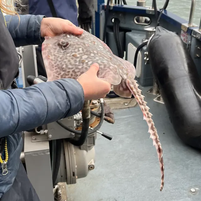 Thornback rayThe commonest European ray, covered in thorn-like bucklers, laying horny egg cases known as mermaid's purses, and requiring careful handling on release.
Ella McCausland — CC BY, via iNaturalist
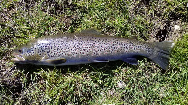 Brown troutA single, extraordinarily plastic species that appears as a tiny hill-stream fish, a deep-bodied loch trout and a silver sea-run migrant — all the same animal.
Robermix, CC0, via Wikimedia Commons
Places within this area
Publicly documented fishing geography. FishingHQ describes what the ground is; it does not say whether you may fish it, and every one of these sends that question to the body that holds the answer. Browse every place in this part of the world.
Who to ask before fishing any of these
FishingHQ does not know the current access position here. Shore angling in Wales is not rod-licensed, but access rights, landowner permission, local authority and harbour byelaws, national and inshore fisheries measures, and site designations all apply and all change. Check the current position with Natural Resources Wales, the harbour or local authority, and the landowner before going.
FishingHQ does not know the current access position here. Shore angling in Wales is not rod-licensed, but access rights, landowner permission, local authority and harbour byelaws, national and inshore fisheries measures, and site designations all apply and all change. Check the current position with Natural Resources Wales, the harbour or local authority, and the landowner before going. This water is tidal and transitional, so the freshwater regime may also apply above the tidal limit: FishingHQ does not know the current access position here. Freshwater rod fishing in Wales requires a current rod licence AND separate permission from whoever controls the fishing, which is frequently a club, riparian owner or navigation authority rather than a public body. Close seasons, byelaws and local rules apply and change. Check with Natural Resources Wales and with the controlling club or owner before going.
Sarn Badrig
Reef · Salt water
A glacial moraine ridge running some twenty kilometres south-west into Cardigan Bay from the Llŷn coast, built of boulder, cobble and gravel left by an ice lobe. It dries in places at low water and continues as a submerged reef far offshore. There is nothing else like the sarnau anywhere in Britain.
Fully open to Cardigan Bay's western fetch. The reef breaks swell along its length, which is exactly what makes it a navigation hazard of long standing.
Particular to this ground: boat safety, tides and being cut off, cold water shock.
Severe hazards of Cardigan Bay and the sarnau apply here: cliffs and rock platforms.
Particular to this water: This ground carries conservation designations that constrain access, vehicles, bait collection and disturbance independently of any fishing rule.
Trefor pier
Pier · Salt water
A granite quarry pier on the north Llŷn coast beneath the Yr Eifl scree slopes, standing in deep water over boulder and rock with steep ground close in.
Severe hazards of Cardigan Bay and the sarnau apply here: boat safety, cliffs and rock platforms, cold water shock.
Aberdaron
Cove · Salt water
A sand and shingle cove at the tip of the Llŷn, between rocky headlands, looking out at the tidal stream running through Bardsey Sound.
Severe hazards of Cardigan Bay and the sarnau apply here: boat safety, cliffs and rock platforms, cold water shock.
Pwllheli
Harbour wall · Salt water
A drying sand harbour behind a shingle spit on the south Llŷn, with training walls, a fast entrance channel and extensive clean sand outside.
Severe hazards of Cardigan Bay and the sarnau apply here: boat safety, cliffs and rock platforms, cold water shock.
Criccieth
Beach · Salt water
Steep shingle over sand beneath a castle crag of volcanic rock, with rock ledges either side of the headland and the shallow water of Tremadog Bay outside.
Severe hazards of Cardigan Bay and the sarnau apply here: boat safety, cliffs and rock platforms, cold water shock.
Porthmadog and the Glaslyn estuary
Estuary · Brackish water
A drying sand estuary behind the Cob embankment, with a narrow shifting entrance across Bar Mouth and extensive intertidal sand and marsh inside.
Severe hazards of Cardigan Bay and the sarnau apply here: boat safety, cliffs and rock platforms, cold water shock.
Barmouth and the Mawddach estuary
Estuary · Brackish water
A steep-sided drowned valley of clean sand and gravel below the Cadair Idris range, with a bar at the mouth and unusually clear water for a British estuary.
Severe hazards of Cardigan Bay and the sarnau apply here: boat safety, cliffs and rock platforms, cold water shock.
Aberdyfi and the Dyfi estuary
Estuary · Brackish water
A large drying sand estuary behind a dune spit, with a shifting bar, extensive saltmarsh and one of the most closely studied sediment systems in Wales.
Severe hazards of Cardigan Bay and the sarnau apply here: boat safety, cliffs and rock platforms, cold water shock.
8 more places in this area
Aberystwyth
Promenade · Salt water
A shingle and sand shore beneath a promenade, between two rocky headlands of folded Silurian mudstone, with a harbour at the Rheidol mouth to the south.
Severe hazards of Cardigan Bay and the sarnau apply here: boat safety, cliffs and rock platforms, cold water shock.
New Quay
Harbour wall · Salt water
A stone pier sheltering a small sand bay on the only substantially north-facing stretch of the Cardigan Bay coast, over sand with reef at both headlands.
Severe hazards of Cardigan Bay and the sarnau apply here: boat safety, cliffs and rock platforms, cold water shock.
Cardigan and the Teifi estuary
Estuary · Brackish water
A narrow drowned valley entered over a shifting sand bar, with rock ledges at the mouth, sand and mud inside, and a substantial migratory fish run.
Severe hazards of Cardigan Bay and the sarnau apply here: boat safety, cliffs and rock platforms, cold water shock.
Aberporth
Rock mark · Salt water
Two small beaches divided by a rocky point, with ledges either side running out over a bottom that is a mixture of rock and sand. The mixture is the mark: clean ground for flatfish within a cast of rough ground for wrasse and conger.
Open north-west into Cardigan Bay.
Particular to this ground: cliffs and rock platforms, tides and being cut off.
Severe hazards of Cardigan Bay and the sarnau apply here: boat safety, cold water shock.
Aberaeron
Beach · Salt water
A small shingle-and-sand town beach either side of the harbour mouth, with rock marks at both ends of it. Mixed ground fished for flatfish and bass off the beach and for conger and pollack off the rock.
Open west into Cardigan Bay.
Severe hazards of Cardigan Bay and the sarnau apply here: boat safety, cliffs and rock platforms, cold water shock.
Borth
Surf beach · Salt water
A long pebble-and-sand storm beach running north from the Dyfi's south shore, backed by a shingle ridge and with the drowned forest showing on the lowest tides. Clean ground with a steep upper bank and a flat lower foreshore.
Open west into Cardigan Bay, and it takes the full weather.
Severe hazards of Cardigan Bay and the sarnau apply here: boat safety, cliffs and rock platforms, cold water shock.
Morfa Nefyn
Beach · Salt water
Two miles of soft sand on the north coast of the Llŷn, broken by rocky outcrops and pebble patches, curving round to Porth Dinllaen at its west end. Sheltered from the south-westerly by the whole peninsula, which is why it fishes when the south coast does not.
Open north; sheltered from the prevailing south-westerly by the peninsula, which is the whole logic of fishing the Llŷn.
Severe hazards of Cardigan Bay and the sarnau apply here: boat safety, cliffs and rock platforms, cold water shock.
Porth Ysgaden
Rock mark · Salt water
A small rocky inlet on the exposed north-west Llŷn used for launching small boats, with low broken rock either side of the cove and kelp in the gullies. Close-range ground rather than a casting mark.
Open north-west with nothing in front of it.
Particular to this ground: cliffs and rock platforms.
Severe hazards of Cardigan Bay and the sarnau apply here: boat safety, cold water shock.
Safety
Boat safety — Can cause serious injury or death
The sarnau are boulder ridges standing several metres above the seabed and running many kilometres offshore, lying across the natural line of travel along the coast. They dry inshore, are covered by variable depth further out, and the tidal stream accelerates across them producing broken water.
What reduces it: Navigate by charted position rather than by eye, know the state of tide over the ridge, allow a genuine margin, and never assume a passage along this coast is clear water.
Worse when:
- In any sea, when the crest breaks and the surrounding water is disturbed.
- On a low spring tide, when the covering depth is least.
Cliffs and rock platforms — Can cause serious injury or death
Much of the Ceredigion coast is cliff of glacial till and shale, which slumps without warning rather than weathering gradually. Sheltering at the foot of one from a westerly places a person directly beneath the failure, and the ground above is undercut.
What reduces it: Do not shelter, sit or set up beneath a soft cliff at any time, keep back from the edge above, and use the open beach and dress for it instead.
Worse when:
- After heavy or prolonged rain, when saturated till slumps.
- Where the face is bare and freshly exposed rather than vegetated.
Cold water shock — Can cause serious injury or death
Water in the bay and in the rivers running into it is cold for most of the year. Immersion produces an involuntary gasp and loss of breathing control within seconds, and much of the sewin fishing is done at night.
What reduces it: Wear a buoyancy aid rather than carry one, wade with a fastened belt and a staff, do not fish or wade alone at night, and carry a means of calling for help on the person.
Moving water and currents — Can cause injury needing treatment
The estuary bars break when an ebbing river flow meets incoming swell over shallow ground, and the spate rivers rise quickly from rain in hills that cannot be seen from the bank.
What reduces it: Cross bars on a flood or at slack rather than a big ebb with a sea running, plan the return against the tide, and get out of a rising or colouring river at the first sign rather than the second.
Further safety reading
- Boat safety for anglers — The sarnau are boulder ridges standing several metres above the seabed and running kilometres offshore across the natural line of travel along the coast, with a long wreck record and broken water over the crest in any sea.
Check the rules before you fish
Fishing laws, bylaws, access rules, seasons, bait restrictions and permitted methods vary by location and can change. Check the current rules from the relevant authority and the water you intend to fish before fishing.
Check with:
- Current national or regional law for where you are fishing
- Current local bylaws
- The relevant fisheries authority
- The landowner, club or fishery whose water it is
- Any restrictions specific to the species or the method you intend to use
Where to go next
What swims here
- Ballan wrasseOn the sarnau themselves and around the hard rock of the Llŷn end. The moraine reefs are the only hard substrate for a long way in an otherwise soft bay, which concentrates rough-ground species onto three narrow strips.
- Brown troutAs sewin — sea trout — in the Dyfi, Mawddach and Teifi and along the coastal margin around their mouths. Sea trout stay close to home at sea, so this bay is their marine habitat rather than a corridor.
- European lobsterIn the interstices of the boulder and cobble of the sarnau, which supply the gaps and cover the species needs and support a creel fishery over ground that would otherwise be featureless sand.
- European sea bassAlong the Ceredigion beaches, around the estuary mouths and over the scour at the ends and flanks of the sarnau, where the moraine reefs interrupt the stream and concentrate food.
- PollackOver the weeded crests and flanks of the sarnau and around the hard headlands, which is rough-ground fishing a long way from any rock coast.
- Thornback rayOver the clean sand and mud adjacent to the reefs and along the open beaches, which is the bay's characteristic soft-ground fishery.
How this compares
Environment and conservation
Sources and evidence
- Cefas science, advice and data on marine and freshwater environments — Centre for Environment, Fisheries and Aquaculture Science (Government fisheries body)Relied on for: Marine environmental science for UK shelf seas, including tidal range and stream, sediment characterisation, coastal process and the monitoring programmes that describe them.States this directlyCitation checked — the work exists and is described correctly
- ICES Advice on fishing opportunities, catch and effort — International Council for the Exploration of the Sea (Scientific institute)Relied on for: Ecoregion description, stock distribution and the hydrography of the sea areas assessed.States this directlyCitation checked — the work exists and is described correctly
- JNCC species and habitat conservation advice — Joint Nature Conservation Committee (Conservation authority)Relied on for: Designation, habitat description and conservation status of the marine and coastal habitats named, and the species characteristically associated with them.States this directlyCitation checked — the work exists and is described correctly
- The Fishes of the British Isles and North-West Europe — Macmillan, 1969 (Reference work)Relied on for: Distribution, habitat association and biology of the fishes of the British Isles and north-west Europe named here.States this directlyCitation checked — the work exists and is described correctly
- RNLI water safety guidance: cold water shock and Float to Live — Royal National Lifeboat Institution (Water-safety or diver-training authority)Relied on for: Cold water shock and the immersion response, tidal cut-off, and water-safety guidance for shore anglers and small-craft users.States this directlyPassage read and verified
- Met Office shipping forecast, inshore waters forecast and marine warnings — Met Office, United Kingdom (Government fisheries body)Relied on for: That inshore waters forecasts, sea state and swell are the operative inputs for shore and small-craft decisions in these waters.States this directlyCitation checked — the work exists and is described correctly
Why the 11 connections on this page are here, and the sources
What swims here
Backed by research — 6 connections
Supported by peer-reviewed research or fisheries science. The sources are listed and can be checked.
Ballan wrasse
A claim that a place contains the ground, water and seasonal conditions the species is associated with. It is a distributional statement about the world, it rests on the regional reference literature, and it deliberately asserts nothing about access, permission or catch.
- The Fishes of the British Isles and North-West Europe — Macmillan, 1969 (Reference work)Relied on for: Distribution and habitat association of the marine, estuarine and freshwater fishes of the British Isles, including which coasts, estuaries and ground types a species occupies.States this directlyCitation checked — the work exists and is described correctly
- FishBase: a global information system on fishes — Froese, R. and D. Pauly, eds. — FishBase Consortium (Scientific institute)Relied on for: Recorded distribution, depth range and habitat association for the species named.States this directlyPassage read and verified
Brown trout
A claim that a place contains the ground, water and seasonal conditions the species is associated with. It is a distributional statement about the world, it rests on the regional reference literature, and it deliberately asserts nothing about access, permission or catch.
- Freshwater Fishes of the British Isles — HarperCollins (New Naturalist 75), 1992 (Reference work)Relied on for: Distribution, ecology and conservation status of the freshwater fishes of the British Isles, including in artificial and modified waters.States this directlyCitation checked — the work exists and is described correctly
- Environment Agency fisheries management, byelaws and rod licensing information — Environment Agency (Government fisheries body)Relied on for: Fisheries monitoring, water quality and species distribution in English rivers, canals and still waters.States this directlyCitation checked — the work exists and is described correctly
European lobster
A claim that a place contains the ground, water and seasonal conditions the species is associated with. It is a distributional statement about the world, it rests on the regional reference literature, and it deliberately asserts nothing about access, permission or catch.
- JNCC species and habitat conservation advice — Joint Nature Conservation Committee (Conservation authority)Relied on for: Habitat classification and description for the intertidal, coastal, estuarine and freshwater habitats named, and the species characteristically associated with them.States this directlyCitation checked — the work exists and is described correctly
- Cefas science, advice and data on marine and freshwater environments — Centre for Environment, Fisheries and Aquaculture Science (Government fisheries body)Relied on for: Characterisation of UK inshore sediment, intertidal habitat, estuarine process and the shellfish beds associated with them.States this directlyCitation checked — the work exists and is described correctly
European sea bass
A claim that a place contains the ground, water and seasonal conditions the species is associated with. It is a distributional statement about the world, it rests on the regional reference literature, and it deliberately asserts nothing about access, permission or catch.
- The Fishes of the British Isles and North-West Europe — Macmillan, 1969 (Reference work)Relied on for: Distribution and habitat association of the marine, estuarine and freshwater fishes of the British Isles, including which coasts, estuaries and ground types a species occupies.States this directlyCitation checked — the work exists and is described correctly
- FishBase: a global information system on fishes — Froese, R. and D. Pauly, eds. — FishBase Consortium (Scientific institute)Relied on for: Recorded distribution, depth range and habitat association for the species named.States this directlyPassage read and verified
Pollack
A claim that a place contains the ground, water and seasonal conditions the species is associated with. It is a distributional statement about the world, it rests on the regional reference literature, and it deliberately asserts nothing about access, permission or catch.
- The Fishes of the British Isles and North-West Europe — Macmillan, 1969 (Reference work)Relied on for: Distribution and habitat association of the marine, estuarine and freshwater fishes of the British Isles, including which coasts, estuaries and ground types a species occupies.States this directlyCitation checked — the work exists and is described correctly
- FishBase: a global information system on fishes — Froese, R. and D. Pauly, eds. — FishBase Consortium (Scientific institute)Relied on for: Recorded distribution, depth range and habitat association for the species named.States this directlyPassage read and verified
Thornback ray
A claim that a place contains the ground, water and seasonal conditions the species is associated with. It is a distributional statement about the world, it rests on the regional reference literature, and it deliberately asserts nothing about access, permission or catch.
- The Fishes of the British Isles and North-West Europe — Macmillan, 1969 (Reference work)Relied on for: Distribution and habitat association of the marine, estuarine and freshwater fishes of the British Isles, including which coasts, estuaries and ground types a species occupies.States this directlyCitation checked — the work exists and is described correctly
- FishBase: a global information system on fishes — Froese, R. and D. Pauly, eds. — FishBase Consortium (Scientific institute)Relied on for: Recorded distribution, depth range and habitat association for the species named.States this directlyPassage read and verified
How people fish here
What experienced anglers do — 2 connections
Widely and independently recommended by experienced anglers and specialist sources. This is real angling knowledge, not proof: controlled evidence for it is limited, and FishingHQ records it as convention rather than as a demonstrated effect.
Fly fishing
A claim about angling convention rather than about the world: that this place sits within this branch of fishing, which drives the information architecture as well as the page. It rests on independent practitioner description.
- General angling website restatements of established technique — Various (Credible secondary source)Relied on for: Widely restated descriptions of which practices are conventionally used in the waters named, recorded as practitioner consensus rather than as scholarship.Background and mechanism onlyCitation checked — the work exists and is described correctly
- Sea Angler — Bauer Media (Specialist angling publication)Relied on for: Long-running published description of British and Irish sea angling practice by region and by ground type.FishingHQ's interpretation of what it saysCitation checked — the work exists and is described correctly
Sea fishing
A claim about angling convention rather than about the world: that this place sits within this branch of fishing, which drives the information architecture as well as the page. It rests on independent practitioner description.
- General angling website restatements of established technique — Various (Credible secondary source)Relied on for: Widely restated descriptions of which practices are conventionally used in the waters named, recorded as practitioner consensus rather than as scholarship.Background and mechanism onlyCitation checked — the work exists and is described correctly
- Sea Angler — Bauer Media (Specialist angling publication)Relied on for: Long-running published description of British and Irish sea angling practice by region and by ground type.FishingHQ's interpretation of what it saysCitation checked — the work exists and is described correctly
How this compares
What experienced anglers do — 1 connection
Widely and independently recommended by experienced anglers and specialist sources. This is real angling knowledge, not proof: controlled evidence for it is limited, and FishingHQ records it as convention rather than as a demonstrated effect.
The Norfolk and Suffolk sandbank coast
A claim that two places are worth reading against one another, because a reader choosing between them or generalising from one to the other needs to know how the underlying process differs.
- General angling website restatements of established technique — Various (Credible secondary source)Relied on for: Widely restated descriptions of which practices are conventionally used in the waters named, recorded as practitioner consensus rather than as scholarship.Background and mechanism onlyCitation checked — the work exists and is described correctly
- Sea Angler — Bauer Media (Specialist angling publication)Relied on for: Long-running published description of British and Irish sea angling practice by region and by ground type.FishingHQ's interpretation of what it saysCitation checked — the work exists and is described correctly
Safety reading
Official guidance — 1 connection
Stated by a fisheries authority, scientific institute or recognised angling body. Authoritative, but summarising rather than demonstrating.
Boat safety for anglers
A claim that a place presents a particular hazard strongly enough that the reader should be sent to the page dealing with it in full, rather than left with the short warning on the place itself.
- RNLI water safety guidance: cold water shock and Float to Live — Royal National Lifeboat Institution (Water-safety or diver-training authority)Relied on for: Cold water shock and the immersion response, tidal cut-off, and water-safety guidance for shore anglers and small-craft users.States this directlyPassage read and verified
Environment and conservation
Backed by research — 1 connection
Supported by peer-reviewed research or fisheries science. The sources are listed and can be checked.
Marine protected areas and spearfishing
A claim that a place raises a particular environmental question, resting on the scientific and conservation literature for the system rather than on angling practice.
- JNCC species and habitat conservation advice — Joint Nature Conservation Committee (Conservation authority)Relied on for: Habitat classification and description for the intertidal, coastal, estuarine and freshwater habitats named, and the species characteristically associated with them.States this directlyCitation checked — the work exists and is described correctly
- Cefas science, advice and data on marine and freshwater environments — Centre for Environment, Fisheries and Aquaculture Science (Government fisheries body)Relied on for: Characterisation of UK inshore sediment, intertidal habitat, estuarine process and the shellfish beds associated with them.States this directlyCitation checked — the work exists and is described correctly
How FishingHQ labels evidence is explained in the evidence policy.