Strangford Lough and the Ards coast
Fishing regions · Last reviewed 2026-08-16
A large, shallow, island-strewn sea lough fed through a narrows that runs one of the strongest and most reliable tidal streams in Europe — reliable enough that a commercial tidal turbine was tested in it.
Safety: moving water and currents — can cause serious injury or death. 3 more points apply here.
Being listed here is not permission to fish. What that meansClose
Access, fishing rights, seasons, licences, local bylaws and permitted methods vary and can change. Check current access, permission, local regulations, closures and restrictions before you travel or fish. FishingHQ describes what the ground is and names who holds the answer; it does not hold the answer itself.
Find the authority for a jurisdiction · What FishingHQ does and does not cover
Strangford Lough is a system-tier record because it is a mechanism rather than a shoreline: a very large body of sea water connected to the Irish Sea through a single narrow channel, so the whole exchange of the lough passes through one gap four times a day.
THE NARROWS ARE THE DEFINING FEATURE. The channel between the lough and the open sea is a few hundred metres wide and several kilometres long, and something in the order of four hundred million cubic metres of water moves through it on each tide. The result is a tidal stream among the fastest in these islands, running with extraordinary regularity, and one of the very few places anywhere where a full-scale grid-connected tidal turbine has been installed and run. That is not a decorative fact; it is the clearest available measurement of what this water does.
THE LOUGH ITSELF IS THE OPPOSITE. Above the narrows the water opens into a broad, shallow basin studded with hundreds of small islands — drumlins, drowned when the sea rose after the last glaciation, which is why they are all the same rounded shape and all lie in the same direction. Between them are shallow channels, extensive intertidal mudflat, eelgrass and some of the richest marine biological diversity in these islands. It is designated for that at every level available.
THE ARDS COAST OUTSIDE is a different animal again: an open, rocky, kelp-fringed east-facing coast running up towards Belfast Lough, exposed to the Irish Sea, with reefs, low cliffs and a series of small harbours.
SO THE SYSTEM HOLDS THREE FISHERIES. A tidal-race fishery in and around the narrows, where the water does the work and the timing is everything. A shallow, sheltered, soft-ground fishery inside the lough. And an exposed rock-coast fishery outside it.
AND IT IS NORTHERN IRELAND'S BEST-KNOWN SEA ANGLING WATER, historically for the common skate fishery of the deep holes off the narrows — a fishery now conducted entirely on catch-and-release terms where it is conducted at all — and currently for tope, spurdog, pollack and a strong general mixed fishery. The Irish Sea's stocks have changed enormously within living memory, and this lough is one of the places that change is most visible.
What fishing here is like
A very large, shallow, almost enclosed sea lough connected to the Irish Sea by a single narrow channel through which the whole tidal exchange passes, producing one of the fastest and most regular tidal streams in these islands. Inside, the lough is broad and shallow, studded with hundreds of rounded drowned drumlin islands, with extensive intertidal mudflat, eelgrass, boulder reef and deep holes scoured by the stream. Outside, the Ards coast is an open, rocky, kelp-fringed east-facing shore exposed to the Irish Sea. Water is cold year-round and clear by Irish Sea standards.
What you can target here
One entry per fish, grouped by how you would be fishing — because the answer is a different one from the rocks and from a boat. Each entry says how strongly the sources support it and how much evidence sits behind it. These are documented catches, not a forecast, and none of it is a statement that you may fish any particular ground.
From the shore · 6
 Ballan wrasseRegular local target1 placeThe Strangford narrowsOver tidal raceAround May–Oct
 PollackRegular local target1 placeThe Strangford narrowsOver tidal raceAround May–Oct
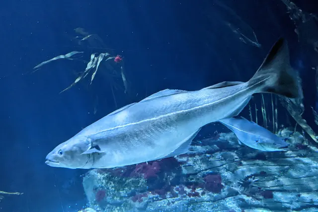 SaitheRegular local target1 placeThe Strangford narrowsOver tidal race
 Atlantic mackerelSeasonal1 placeThe Strangford narrowsOver tidal raceAround Jun–Sept
 Thick-lipped grey mulletSeasonal1 placeThe Strangford narrowsOver tidal raceAround Jun–Sept
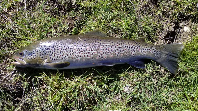 Brown troutRecorded here1 placeThe Strangford narrowsOver tidal race
What these strengths mean
- Regular local target
- Fishing sources describe this as a normal local target here, not merely as caught.
- Seasonal
- Well supported, and concentrated in part of the year rather than spread through it.
- Recorded here
- At least one credible public account of this species being caught here. That is all it means.
- How breadth is counted
- A fish documented at six marks is shown as six marks: breadth never raises the strength on its own. A fishery account describes the fishing; a recorded catch reports one specific catch. How evidence is weighed.
How people fish here
5 methods are recorded on the places documented here, counted from the records themselves rather than from what is practised in the country. Each opens a full guide to the technique.
Float fishing
Recorded at 2 places here, over river reach, tidal race.
Suspending a bait at a controlled depth beneath a buoyant indicator — the most visual, most controllable and most widely applicable method in angling.
Documented on the same ground: Ballan wrasse, Pollack, Saithe, Atlantic mackerel, Thick-lipped grey mullet, Brown trout.
Spinning
Recorded at 2 places here, over river reach, tidal race.
Casting an artificial lure and retrieving it so that it moves like something alive — the most direct form of lure fishing.
Documented on the same ground: Ballan wrasse, Pollack, Saithe, Atlantic mackerel, Thick-lipped grey mullet, Brown trout.
Deadbaiting
Recorded at 1 place here, over river reach.
Presenting a dead fish as bait for predators — a method that works because scavenging is normal predator behaviour, not an exception.
Jigging
Recorded at 1 place here, over tidal race.
Working a weighted lure with a rising-and-falling motion, usually vertically, so it behaves like a wounded or fleeing baitfish.
Documented on the same ground: Ballan wrasse, Pollack, Saithe, Atlantic mackerel, Thick-lipped grey mullet, Brown trout.
Kayak fishing
Recorded at 1 place here, over tidal race.
A platform rather than a technique: quiet, shallow-draught access to water no other craft reaches, bought at the price of exposure, and a discipline where the decision not to launch is part of the skill.
Documented on the same ground: Ballan wrasse, Pollack, Saithe, Atlantic mackerel, Thick-lipped grey mullet, Brown trout.
These are the methods documented at the places FishingHQ holds here. A species listed beside a method is documented on the same ground, which is not the same as being taken that way — where a source establishes the method a fish was caught on, it is stated on that place’s own page. All fishing methods.
The fishing year here
The months the records under this area actually name, tightest season first. This is “observed in these months” rather than a season: a species whose months nobody recorded is not listed, because a gap in the evidence is not a year-round fishery.
- Atlantic mackerelJune to September
- Thick-lipped grey mulletJune to September
- Ballan wrasseMay to October
- PollackMay to October
What dominates
Small-boat and charter fishing in the lough and around the narrows, which is what this water is known for and which is entirely organised around the tide. Shore fishing from rock, pier and shingle along the Ards coast and at the narrows. Lure and float fishing for pollack, coalfish and wrasse over the boulder reef and kelp. Flatfish and general bottom fishing over the soft ground inside the lough. Kayak fishing in the sheltered inner lough, with the strong caveat that the narrows are not kayak water on a running tide at any level of skill. Diving, which is well established here because of the biological richness and the clarity. Creeling and shore gathering, subject to classification and rules.
The water available
A high-energy tidal narrows with overfalls, boils and scoured deep holes; a large shallow sheltered basin with hundreds of drumlin islands and shallow channels between them; extensive intertidal mudflat, sandflat and eelgrass; boulder reef and horse-mussel beds of exceptional biological richness; open rocky kelp-fringed coast outside the lough; and small harbours and piers along both.
How the rules are structured
Northern Ireland has its own fisheries framework and it is NOT the England and Wales one — an angler who assumes otherwise will be wrong about several things. Sea angling requires no licence, but national and EU-derived conservation measures, minimum sizes and species-specific rules apply and are administered by the Northern Ireland department responsible for fisheries. Freshwater and migratory fishing require both a rod licence and a separate permit, and the licensing bodies differ between parts of the country, which catches visitors constantly. Strangford Lough carries the densest stack of conservation designations of any marine site in Northern Ireland, covering its habitats, its horse-mussel beds, its birds and its seals, and those designations constrain anchoring, access, collection and disturbance independently of any fishing rule. Shellfish harvesting areas are classified for food safety. Common skate is a protected species subject to specific rules. FishingHQ does not state what any current rule is.
Who to ask
- The Northern Ireland department responsible for agriculture, environment and rural affairs, which administers sea fisheries measures and marine conservation here.
- The Loughs Agency or the Northern Ireland licensing body as applicable, for rod licensing and permits on freshwater and migratory fisheries, which differ by area.
- The Northern Ireland Environment Agency and the site management bodies, where a marine designation affects anchoring, access, collection or disturbance.
- The harbour authority at each port, for access to and fishing from harbour structures.
- The local district council and the Food Standards Agency framework, for shellfish harvesting area classification.
Words you will meet
- The Narrows
- The single channel connecting the lough to the Irish Sea, a few hundred metres wide and several kilometres long, through which the entire tidal exchange of the lough passes. Local timing, fishing and navigation are all organised around what the Narrows are doing.
- Pladdy
- A low rocky islet or reef in Strangford Lough that covers at high water and dries at low. The pladdies are the lough's structure, they are numerous, many are unmarked, and they are the principal hazard to a boat inside the lough.
- Drumlin
- A rounded hill of glacial till. Strangford's hundreds of islands are drowned drumlins, which is why they all share a shape and an alignment, and why the lough's bed is the same landscape continuing under water.
Conditions and hazards
The tidal stream is the dominant hazard and its regularity makes it more dangerous rather than less, because it is always there. Through the narrows the stream runs faster than any small craft can make ground against, producing overfalls, boils and standing water that form and disperse on the clock rather than with the weather — the same piece of water is flat and lethal at different hours of the same day. A craft that entered the acceleration is going where the water goes. Inside the lough the hazard changes completely: hundreds of unmarked or barely marked rocky pladdies lie just below the surface, invisible in a ripple, and striking one at speed is the characteristic boat accident here. The lough is shallow and large enough to raise a steep sea quickly in wind. Outside on the Ards coast it is an ordinary exposed rock coast with Irish Sea swell arriving in sets on kelp-covered ledges. Water is cold year-round throughout, so cold water shock rather than swimming ability decides an immersion in any month, and the extensive intertidal mud inside the lough fills from the channels outward with ground that will not carry weight on the return.
Four hundred million cubic metres through one gap, four times a day
Strangford is the clearest demonstration in these islands of what happens when a very large body of sea water is given only one small door.
THE ARITHMETIC IS THE WHOLE STORY. A broad, shallow lough covering a large area has to fill and empty twice a day through a channel a few hundred metres wide. The volume involved is enormous — on the order of hundreds of millions of cubic metres per tide — and it all has to pass through the same gap in about six hours. The consequence is a stream running at speeds that put it among the fastest in Europe, with overfalls, boils and eddies where it meets the sides, the sill and the water going the other way.
THE REGULARITY IS WHAT MAKES IT REMARKABLE. Wind-driven currents are unpredictable; this is not. The stream turns on the tidal clock, it runs to broadly the same strength on the same states, and it does so whatever the weather is doing. That reliability is why a full-scale grid-connected tidal turbine was installed and operated here — an engineering decision made on measurements rather than reputation, and the best available external verification of what this water is.
WHAT IT DOES FOR THE FISHING. A hard stream through a constriction concentrates food, disorients prey and scours deep holes on the bends and at the exits. Those holes are the historic ground of the lough's most famous fishery. Pollack, coalfish, mackerel and wrasse hold in the slacker water on the edges of the stream and feed on what it delivers. The fishing is not spread over the tide — it is concentrated into specific parts of specific states, and an angler who has not planned around that has planned around nothing.
AND THE SKATE FISHERY IS THE HISTORICAL WEIGHT. The deep scoured holes here held common skate, an enormous, slow-growing, late-maturing elasmobranch, and the lough was among the best-known places in these islands to catch one. Common skate has since become one of the clearest examples anywhere of a species fished to a fraction of its range: it is protected, its retention is prohibited, and where it is fished for at all it is on strict catch-and-release terms with specific handling requirements. That change happened inside a single angling generation and this water is where it is most visible.
THE SAFE VERSION OF ALL OF THIS is that the timing here is not a preference. Local knowledge about when the stream turns at a specific place, rather than at a distant standard port, is the operative information, and it is the first thing to obtain.
Backed by research — why, and the sources (4)
Supported by peer-reviewed research or fisheries science. The sources are listed and can be checked.
- Cefas science, advice and data on marine and freshwater environments — Centre for Environment, Fisheries and Aquaculture Science (Government fisheries body)Relied on for: Marine environmental science for UK shelf seas, including tidal range and stream, sediment characterisation, coastal process and the monitoring programmes that describe them.States this directlyCitation checked — the work exists and is described correctly
- ICES Advice on fishing opportunities, catch and effort — International Council for the Exploration of the Sea (Scientific institute)Relied on for: Ecoregion description, stock distribution and the hydrography of the sea areas assessed.States this directlyCitation checked — the work exists and is described correctly
- JNCC species and habitat conservation advice — Joint Nature Conservation Committee (Conservation authority)Relied on for: Designation, habitat description and conservation status of the marine and coastal habitats named, and the species characteristically associated with them.States this directlyCitation checked — the work exists and is described correctly
- The Fishes of the British Isles and North-West Europe — Macmillan, 1969 (Reference work)Relied on for: Distribution, habitat association and biology of the fishes of the British Isles and north-west Europe named here.States this directlyCitation checked — the work exists and is described correctly
A drowned drumlin field, and why it is the richest sea bed in Ireland
Above the narrows the lough is a landscape that used to be dry, and the shape of that landscape explains why this is one of the most biologically important marine sites in these islands.
DRUMLINS ARE GLACIAL. An ice sheet moving over soft ground moulds it into long rounded hills all aligned with the direction of flow. County Down has a classic drumlin field, and when sea level rose after the last glaciation the sea flooded the low ground between them. The islands in the lough are the tops of those hills, which is why there are hundreds of them, why they are all the same rounded shape, and why they all point the same way. The bed of the lough is the same landscape continuing under water.
WHAT THAT GIVES BIOLOGICALLY IS VARIETY IN A SMALL SPACE. Shallow sheltered mud between the drumlins. Scoured hard ground where channels run between them. Boulder and cobble on the island flanks. Extensive intertidal flat and eelgrass in the bays. And in places, horse-mussel beds — dense biogenic reef built by the animals themselves, which supports a great deal else and which is slow to form and easily damaged.
THE RESULT IS AN EXCEPTIONAL SPECIES LIST for a temperate sea lough, and the density of conservation designation to match. That has direct consequences for anglers and divers: anchoring restrictions exist in places to protect the reef, collection is constrained, and disturbance rules apply around the seal haul-outs. Those constraints are not incidental bureaucracy layered onto a fishing venue; they are the reason there is anything here worth fishing over.
WHAT AN ANGLER ACTUALLY MEETS. Pollack and coalfish over the boulder and kelp, particularly around the islands where the stream runs. Ballan wrasse on the same ground through the warmer months. Mackerel through the summer in the narrows and the outer lough. Flatfish over the soft ground inside — dab, plaice and flounder. Tope and spurdog in the deeper water, which are the modern boat fishery. Thornback ray over the mixed ground. And a general mixed bag that reflects an Irish Sea whose composition has changed substantially in fifty years.
THE HONEST NOTE. The Irish Sea's round-fish stocks are much reduced from their historical state, and the lough's angling reputation was built when they were not. What is there now is worth fishing for on its own terms rather than as a disappointing version of an older account.
Backed by research — why, and the sources (4)
Supported by peer-reviewed research or fisheries science. The sources are listed and can be checked.
- JNCC species and habitat conservation advice — Joint Nature Conservation Committee (Conservation authority)Relied on for: Designation, habitat description and conservation status of the marine and coastal habitats named, and the species characteristically associated with them.States this directlyCitation checked — the work exists and is described correctly
- The Fishes of the British Isles and North-West Europe — Macmillan, 1969 (Reference work)Relied on for: Distribution, habitat association and biology of the fishes of the British Isles and north-west Europe named here.States this directlyCitation checked — the work exists and is described correctly
- Cefas science, advice and data on marine and freshwater environments — Centre for Environment, Fisheries and Aquaculture Science (Government fisheries body)Relied on for: Marine environmental science for UK shelf seas, including tidal range and stream, sediment characterisation, coastal process and the monitoring programmes that describe them.States this directlyCitation checked — the work exists and is described correctly
- ICES Advice on fishing opportunities, catch and effort — International Council for the Exploration of the Sea (Scientific institute)Relied on for: Ecoregion description, stock distribution and the hydrography of the sea areas assessed.States this directlyCitation checked — the work exists and is described correctly
A stream that runs to a clock, and a lough full of rocks you cannot see
This system carries two entirely different serious hazards a few kilometres apart, and neither of them is weather.
THE NARROWS ARE THE FIRST, AND THEIR REGULARITY IS THE TRAP. A stream this strong is not an occasional event to be waited out; it is there four times a day, every day, whatever the sky is doing. So the same piece of water is genuinely benign and genuinely dangerous at different hours of the same afternoon, and a passage made comfortably on the slack is not evidence about the return an hour and a half later. That specific misreading — treating an earlier crossing as information about a later one — is how this water catches people.
WHAT THE STREAM ACTUALLY DOES. It runs faster than a kayak can paddle or a small outboard can push against, so a craft that enters the acceleration is committed to wherever the water goes. It produces overfalls, boils and sharp shear lines where it meets the sides and the sill, and a shear line pushes hard on one side of a hull and not the other, which spins a small boat. Wind against the stream stands the whole thing up into short steep breaking water out of proportion to the wind strength.
SO THE PLANNING ORDER IS TIDE FIRST. Get the timing for the Narrows themselves rather than for a standard port elsewhere, plan the return as carefully as the outward passage, and treat visible overfalls as a boundary with a wide margin because their position moves through the cycle.
INSIDE THE LOUGH THE HAZARD INVERTS. There is no stream to speak of in much of it and the danger is the bottom: hundreds of pladdies — low rocky islets and reefs — many of them unmarked, many of them just covered, and all of them invisible once there is a ripple on the water. Striking one at speed is the characteristic boat accident here. In flat calm a covered rock shows as a slick; in the chop that makes the fishing it does not. Keep to known passages, go slowly on unfamiliar water, and take local knowledge seriously — it is held by people rather than published.
THE LOUGH IS ALSO LARGE AND SHALLOW, which means it raises a steep short sea quickly in wind, and conditions in the open middle can be quite different from what they look like from a sheltered bay.
OUTSIDE ON THE ARDS COAST it is an ordinary exposed rock coast with Irish Sea swell arriving in sets onto kelp-covered ledges. Watch a full set before committing, choose a position with a way up, and wear a buoyancy aid.
AND THE WATER IS COLD IN EVERY MONTH throughout the system. Immersion produces the gasp response and loss of breathing control within seconds, which is what decides the outcome. The intertidal mud inside the lough fills from the channels outward and will not carry weight on the way back. Wear the buoyancy aid rather than carrying it, carry the means of calling for help on the person, and check the current tidal predictions for the Narrows before going.
Official guidance — why, and the sources (4)
Stated by a fisheries authority, scientific institute or recognised angling body. Authoritative, but summarising rather than demonstrating.
- RNLI water safety guidance: cold water shock and Float to Live — Royal National Lifeboat Institution (Water-safety or diver-training authority)Relied on for: Cold water shock and the immersion response, tidal cut-off, and water-safety guidance for shore anglers and small-craft users.States this directlyPassage read and verified
- Met Office shipping forecast, inshore waters forecast and marine warnings — Met Office, United Kingdom (Government fisheries body)Relied on for: That inshore waters forecasts, sea state and swell are the operative inputs for shore and small-craft decisions in these waters.States this directlyCitation checked — the work exists and is described correctly
- Cefas science, advice and data on marine and freshwater environments — Centre for Environment, Fisheries and Aquaculture Science (Government fisheries body)Relied on for: Marine environmental science for UK shelf seas, including tidal range and stream, sediment characterisation, coastal process and the monitoring programmes that describe them.States this directlyCitation checked — the work exists and is described correctly
- ICES Advice on fishing opportunities, catch and effort — International Council for the Exploration of the Sea (Scientific institute)Relied on for: Ecoregion description, stock distribution and the hydrography of the sea areas assessed.States this directlyCitation checked — the work exists and is described correctly
Some of what lives here
Fish recorded here that FishingHQ holds a reviewed photograph of. It is not a complete list of what Strangford Lough and the Ards coast holds, and it is not a prediction that you will catch any of them — it is a way in to the ones we can show you.
- PollackA fast gadoid that hunts up off reefs and wrecks and takes a lure on the drop — and the sea fish most likely to convert a bait angler to lure fishing.
Wilhelm Thomas Fiege — CC BY-SA 4.0, via Wikimedia Commons
- SaitheA fast, hard-fighting shoaling gadoid of northern rock and wreck — routinely confused with pollack, and a completely different fish once you know the lateral line.
Wilhelm Thomas Fiege — CC BY-SA 4.0, via Wikimedia Commons
- Ballan wrasseA long-lived rocky-ground resident that begins life female and may change sex — and the species that turned rock marks into a lure fishery.
Diego Delso — CC BY-SA 4.0, via Wikimedia Commons
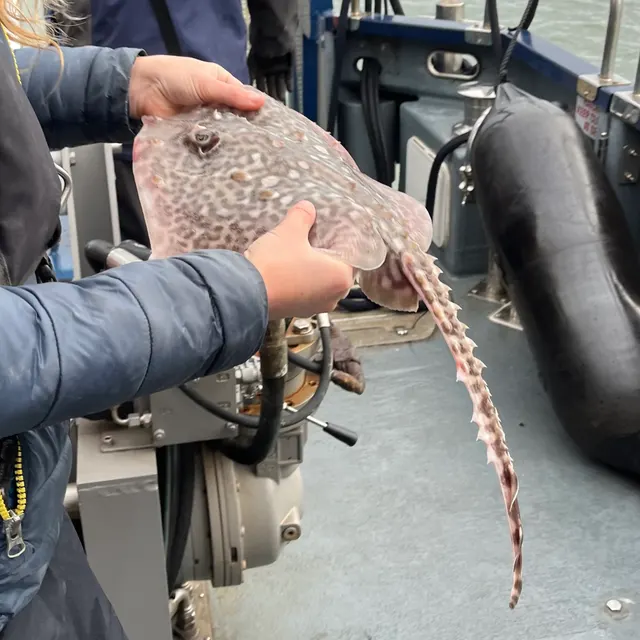 Thornback rayThe commonest European ray, covered in thorn-like bucklers, laying horny egg cases known as mermaid's purses, and requiring careful handling on release.
Ella McCausland — CC BY, via iNaturalist
- Atlantic mackerelA fast, schooling, obligate-swimming pelagic fish that arrives inshore in summer in enormous numbers, and the species most sea anglers catch first.
Hans Hillewaert — CC BY-SA 4.0, via Wikimedia Commons
Places within this area
Publicly documented fishing geography. FishingHQ describes what the ground is; it does not say whether you may fish it, and every one of these sends that question to the body that holds the answer. Browse every place in this part of the world.
Who to ask before fishing any of these
FishingHQ does not know the current access position here. Sea angling access in Northern Ireland is governed by landowner permission, harbour and council byelaws, and fisheries and conservation measures, all of which change. Check the current position with the Department of Agriculture, Environment and Rural Affairs, the harbour or council, and the landowner before going.
FishingHQ does not know the current access position here. Sea angling access in Northern Ireland is governed by landowner permission, harbour and council byelaws, and fisheries and conservation measures, all of which change. Check the current position with the Department of Agriculture, Environment and Rural Affairs, the harbour or council, and the landowner before going. This water is tidal and transitional, so the freshwater regime may also apply above the tidal limit: FishingHQ does not know the current access position here. Angling in Northern Ireland generally requires both a rod licence from the relevant fisheries body and a separate permit for the water, and the two are issued by different bodies. Rules, seasons and permit arrangements change. Check with the Department of Agriculture, Environment and Rural Affairs, the Loughs Agency where relevant, and the permit issuer before going.
The Strangford narrows
Tidal race · Salt water
An eight-kilometre channel a few hundred metres wide connecting Strangford Lough to the Irish Sea, with a rock and boulder bed, deep scoured holes and the Routen Wheel — a permanent whirlpool feature — partway along it.
Sheltered from swell; the danger here is entirely tidal. The lough behind it is one of the most sheltered large bodies of water in the British Isles.
Particular to this ground: moving water and currents, cold water shock.
Severe hazards of Strangford Lough and the Ards coast apply here: boat safety.
Particular to this water: This ground carries conservation designations that constrain access, vehicles, bait collection and disturbance independently of any fishing rule.
The Quoile
River reach · Brackish water
A river impounded behind a tidal barrage at the head of Strangford Lough, converting a tidal estuary into a freshwater pondage with a distinctive transitional ecology.
Severe hazards of Strangford Lough and the Ards coast apply here: moving water and currents, boat safety, cold water shock.
Safety
Moving water and currents — Can cause serious injury or death
The entire tidal exchange of a very large lough passes through one narrow channel, producing a stream faster than any small craft can make ground against, with overfalls, boils and sharp shear lines. A craft that enters the acceleration goes where the water goes.
What reduces it: Get the timing for the Narrows themselves rather than a distant standard port, plan the return as carefully as the outward passage, never enter with wind against stream, and treat visible overfalls as a boundary with a wide margin.
Worse when:
- On spring tides, when the stream runs hardest and the overfalls are largest.
- With wind against the stream, which stands the race up into steep breaking water.
Boat safety — Can cause serious injury or death
The lough is strewn with hundreds of rocky pladdies, many unmarked and many just covered. They show as a slick in flat calm and are invisible in the ripple that makes the fishing, and striking one at speed can hole or capsize a boat.
What reduces it: Keep to known passages, go slowly on unfamiliar water, take local knowledge of the safe routes before travelling at speed, and treat a chop as a reason to slow down rather than to press on.
Cold water shock — Can cause serious injury or death
Water throughout the system is cold in every month. Immersion produces an involuntary gasp and loss of breathing control within seconds, which decides the outcome rather than any swimming afterwards.
What reduces it: Wear a buoyancy aid rather than carry one, do not go out alone, carry a means of calling for help on the person, and dress for the water rather than the day.
Tides and being cut off — Can cause injury needing treatment
Extensive intertidal mud and sand inside the lough fills from the channels outward rather than from the sea inward, and ground that carried weight on the way out will not on the way back.
What reduces it: Know the state of the tide and the exit before going onto any flat, set a leaving time from the tide rather than from the fishing, and do not go out onto soft ground alone.
Further safety reading
- Boat safety for anglers — A stream through the narrows that no small craft can make ground against, and a lough interior strewn with unmarked pladdies that are invisible in the ripple that makes the fishing.
Check the rules before you fish
Fishing laws, bylaws, access rules, seasons, bait restrictions and permitted methods vary by location and can change. Check the current rules from the relevant authority and the water you intend to fish before fishing.
Check with:
- Current national or regional law for where you are fishing
- Current local bylaws
- The relevant fisheries authority
- The landowner, club or fishery whose water it is
- Any restrictions specific to the species or the method you intend to use
Where to go next
What swims here
- Atlantic mackerelThrough the summer in the narrows and the outer lough, where the tidal stream concentrates food and the fish with it.
- Ballan wrasseOn the boulder and kelp ground of the island shores and the Ards coast through the warmer months.
- DabOver the soft and mixed ground of the lough's shallower basins, alongside plaice and flounder, which is the general bottom fishery inside the narrows.
- PollackOver the boulder reef and kelp around the islands and in the narrows, holding in the slack water on the edges of the stream and feeding on what it delivers.
- SaitheAround the narrows, the pladdies and the harbour structures, in numbers, and the fish most casual shore sessions on this lough encounter.
- Thornback rayOver the mixed and softer ground inside the lough, principally through the warmer months.
How this compares
Environment and conservation
- Fish stocks and sustainabilityThe deep scoured holes here held common skate and the lough was among the best-known places in these islands to catch one. That species is now protected, its retention prohibited, and the change happened inside a single angling generation.
- Marine protected areas and spearfishingThis lough carries the densest stack of conservation designations of any marine site in Northern Ireland, covering its horse-mussel reef, its habitats, its birds and its seals, and those designations constrain anchoring, access, collection and disturbance independently of any fishing rule.
Sources and evidence
- Cefas science, advice and data on marine and freshwater environments — Centre for Environment, Fisheries and Aquaculture Science (Government fisheries body)Relied on for: Marine environmental science for UK shelf seas, including tidal range and stream, sediment characterisation, coastal process and the monitoring programmes that describe them.States this directlyCitation checked — the work exists and is described correctly
- ICES Advice on fishing opportunities, catch and effort — International Council for the Exploration of the Sea (Scientific institute)Relied on for: Ecoregion description, stock distribution and the hydrography of the sea areas assessed.States this directlyCitation checked — the work exists and is described correctly
- JNCC species and habitat conservation advice — Joint Nature Conservation Committee (Conservation authority)Relied on for: Designation, habitat description and conservation status of the marine and coastal habitats named, and the species characteristically associated with them.States this directlyCitation checked — the work exists and is described correctly
- The Fishes of the British Isles and North-West Europe — Macmillan, 1969 (Reference work)Relied on for: Distribution, habitat association and biology of the fishes of the British Isles and north-west Europe named here.States this directlyCitation checked — the work exists and is described correctly
- RNLI water safety guidance: cold water shock and Float to Live — Royal National Lifeboat Institution (Water-safety or diver-training authority)Relied on for: Cold water shock and the immersion response, tidal cut-off, and water-safety guidance for shore anglers and small-craft users.States this directlyPassage read and verified
- Met Office shipping forecast, inshore waters forecast and marine warnings — Met Office, United Kingdom (Government fisheries body)Relied on for: That inshore waters forecasts, sea state and swell are the operative inputs for shore and small-craft decisions in these waters.States this directlyCitation checked — the work exists and is described correctly
Why the 12 connections on this page are here, and the sources
What swims here
Backed by research — 6 connections
Supported by peer-reviewed research or fisheries science. The sources are listed and can be checked.
Atlantic mackerel
A claim that a place contains the ground, water and seasonal conditions the species is associated with. It is a distributional statement about the world, it rests on the regional reference literature, and it deliberately asserts nothing about access, permission or catch.
- The Fishes of the British Isles and North-West Europe — Macmillan, 1969 (Reference work)Relied on for: Distribution and habitat association of the marine, estuarine and freshwater fishes of the British Isles, including which coasts, estuaries and ground types a species occupies.States this directlyCitation checked — the work exists and is described correctly
- FishBase: a global information system on fishes — Froese, R. and D. Pauly, eds. — FishBase Consortium (Scientific institute)Relied on for: Recorded distribution, depth range and habitat association for the species named.States this directlyPassage read and verified
Ballan wrasse
A claim that a place contains the ground, water and seasonal conditions the species is associated with. It is a distributional statement about the world, it rests on the regional reference literature, and it deliberately asserts nothing about access, permission or catch.
- The Fishes of the British Isles and North-West Europe — Macmillan, 1969 (Reference work)Relied on for: Distribution and habitat association of the marine, estuarine and freshwater fishes of the British Isles, including which coasts, estuaries and ground types a species occupies.States this directlyCitation checked — the work exists and is described correctly
- FishBase: a global information system on fishes — Froese, R. and D. Pauly, eds. — FishBase Consortium (Scientific institute)Relied on for: Recorded distribution, depth range and habitat association for the species named.States this directlyPassage read and verified
Dab
A claim that a place contains the ground, water and seasonal conditions the species is associated with. It is a distributional statement about the world, it rests on the regional reference literature, and it deliberately asserts nothing about access, permission or catch.
- The Fishes of the British Isles and North-West Europe — Macmillan, 1969 (Reference work)Relied on for: Distribution and habitat association of the marine, estuarine and freshwater fishes of the British Isles, including which coasts, estuaries and ground types a species occupies.States this directlyCitation checked — the work exists and is described correctly
- FishBase: a global information system on fishes — Froese, R. and D. Pauly, eds. — FishBase Consortium (Scientific institute)Relied on for: Recorded distribution, depth range and habitat association for the species named.States this directlyPassage read and verified
Pollack
A claim that a place contains the ground, water and seasonal conditions the species is associated with. It is a distributional statement about the world, it rests on the regional reference literature, and it deliberately asserts nothing about access, permission or catch.
- The Fishes of the British Isles and North-West Europe — Macmillan, 1969 (Reference work)Relied on for: Distribution and habitat association of the marine, estuarine and freshwater fishes of the British Isles, including which coasts, estuaries and ground types a species occupies.States this directlyCitation checked — the work exists and is described correctly
- FishBase: a global information system on fishes — Froese, R. and D. Pauly, eds. — FishBase Consortium (Scientific institute)Relied on for: Recorded distribution, depth range and habitat association for the species named.States this directlyPassage read and verified
Saithe
A claim that a place contains the ground, water and seasonal conditions the species is associated with. It is a distributional statement about the world, it rests on the regional reference literature, and it deliberately asserts nothing about access, permission or catch.
- The Fishes of the British Isles and North-West Europe — Macmillan, 1969 (Reference work)Relied on for: Distribution and habitat association of the marine, estuarine and freshwater fishes of the British Isles, including which coasts, estuaries and ground types a species occupies.States this directlyCitation checked — the work exists and is described correctly
- FishBase: a global information system on fishes — Froese, R. and D. Pauly, eds. — FishBase Consortium (Scientific institute)Relied on for: Recorded distribution, depth range and habitat association for the species named.States this directlyPassage read and verified
Thornback ray
A claim that a place contains the ground, water and seasonal conditions the species is associated with. It is a distributional statement about the world, it rests on the regional reference literature, and it deliberately asserts nothing about access, permission or catch.
- The Fishes of the British Isles and North-West Europe — Macmillan, 1969 (Reference work)Relied on for: Distribution and habitat association of the marine, estuarine and freshwater fishes of the British Isles, including which coasts, estuaries and ground types a species occupies.States this directlyCitation checked — the work exists and is described correctly
- FishBase: a global information system on fishes — Froese, R. and D. Pauly, eds. — FishBase Consortium (Scientific institute)Relied on for: Recorded distribution, depth range and habitat association for the species named.States this directlyPassage read and verified
How people fish here
What experienced anglers do — 2 connections
Widely and independently recommended by experienced anglers and specialist sources. This is real angling knowledge, not proof: controlled evidence for it is limited, and FishingHQ records it as convention rather than as a demonstrated effect.
Freediving for spearfishing
A claim about angling convention rather than about the world: that this place sits within this branch of fishing, which drives the information architecture as well as the page. It rests on independent practitioner description.
- General angling website restatements of established technique — Various (Credible secondary source)Relied on for: Widely restated descriptions of which practices are conventionally used in the waters named, recorded as practitioner consensus rather than as scholarship.Background and mechanism onlyCitation checked — the work exists and is described correctly
- Sea Angler — Bauer Media (Specialist angling publication)Relied on for: Long-running published description of British and Irish sea angling practice by region and by ground type.FishingHQ's interpretation of what it saysCitation checked — the work exists and is described correctly
Sea fishing
A claim about angling convention rather than about the world: that this place sits within this branch of fishing, which drives the information architecture as well as the page. It rests on independent practitioner description.
- General angling website restatements of established technique — Various (Credible secondary source)Relied on for: Widely restated descriptions of which practices are conventionally used in the waters named, recorded as practitioner consensus rather than as scholarship.Background and mechanism onlyCitation checked — the work exists and is described correctly
- Sea Angler — Bauer Media (Specialist angling publication)Relied on for: Long-running published description of British and Irish sea angling practice by region and by ground type.FishingHQ's interpretation of what it saysCitation checked — the work exists and is described correctly
How this compares
What experienced anglers do — 1 connection
Widely and independently recommended by experienced anglers and specialist sources. This is real angling knowledge, not proof: controlled evidence for it is limited, and FishingHQ records it as convention rather than as a demonstrated effect.
The Firth of Clyde
A claim that two places are worth reading against one another, because a reader choosing between them or generalising from one to the other needs to know how the underlying process differs.
- General angling website restatements of established technique — Various (Credible secondary source)Relied on for: Widely restated descriptions of which practices are conventionally used in the waters named, recorded as practitioner consensus rather than as scholarship.Background and mechanism onlyCitation checked — the work exists and is described correctly
- Sea Angler — Bauer Media (Specialist angling publication)Relied on for: Long-running published description of British and Irish sea angling practice by region and by ground type.FishingHQ's interpretation of what it saysCitation checked — the work exists and is described correctly
Safety reading
Official guidance — 1 connection
Stated by a fisheries authority, scientific institute or recognised angling body. Authoritative, but summarising rather than demonstrating.
Boat safety for anglers
A claim that a place presents a particular hazard strongly enough that the reader should be sent to the page dealing with it in full, rather than left with the short warning on the place itself.
- RNLI water safety guidance: cold water shock and Float to Live — Royal National Lifeboat Institution (Water-safety or diver-training authority)Relied on for: Cold water shock and the immersion response, tidal cut-off, and water-safety guidance for shore anglers and small-craft users.States this directlyPassage read and verified
Environment and conservation
Backed by research — 2 connections
Supported by peer-reviewed research or fisheries science. The sources are listed and can be checked.
Fish stocks and sustainability
A claim that a place raises a particular environmental question, resting on the scientific and conservation literature for the system rather than on angling practice.
- JNCC species and habitat conservation advice — Joint Nature Conservation Committee (Conservation authority)Relied on for: Habitat classification and description for the intertidal, coastal, estuarine and freshwater habitats named, and the species characteristically associated with them.States this directlyCitation checked — the work exists and is described correctly
- Cefas science, advice and data on marine and freshwater environments — Centre for Environment, Fisheries and Aquaculture Science (Government fisheries body)Relied on for: Characterisation of UK inshore sediment, intertidal habitat, estuarine process and the shellfish beds associated with them.States this directlyCitation checked — the work exists and is described correctly
Marine protected areas and spearfishing
A claim that a place raises a particular environmental question, resting on the scientific and conservation literature for the system rather than on angling practice.
- JNCC species and habitat conservation advice — Joint Nature Conservation Committee (Conservation authority)Relied on for: Habitat classification and description for the intertidal, coastal, estuarine and freshwater habitats named, and the species characteristically associated with them.States this directlyCitation checked — the work exists and is described correctly
- Cefas science, advice and data on marine and freshwater environments — Centre for Environment, Fisheries and Aquaculture Science (Government fisheries body)Relied on for: Characterisation of UK inshore sediment, intertidal habitat, estuarine process and the shellfish beds associated with them.States this directlyCitation checked — the work exists and is described correctly
How FishingHQ labels evidence is explained in the evidence policy.