The Purbeck coast and Poole Bay
Fishing regions · Last reviewed 2026-08-28
A limestone coast of ledges and a sheltered bay behind it, so an angler can fish full Channel exposure and near-flat water within the same few miles depending on which side of the Head they choose.
Safety: cliffs and rock platforms — can cause serious injury or death. 6 more points apply here.
Fishing here at a glance
- Ways to fish
- From the shore
- Plan a trip
- When is best · Baits and lures to bring · Open the trip planner
- Rules and access
- Who sets the rules here — being listed is never permission to fish.
Not documented here yet: tackle shops, charters or guides.
Being listed here is not permission to fish. What that meansClose
Access, fishing rights, seasons, licences, local bylaws and permitted methods vary and can change. Check current access, permission, local regulations, closures and restrictions before you travel or fish. FishingHQ describes what the ground is and names who holds the answer; it does not hold the answer itself.
Find the authority for a jurisdiction · What FishingHQ does and does not cover
The Isle of Purbeck is not an island and it is the most abruptly divided piece of coast in southern England.
THE SOUTH SIDE IS LEDGE AND CLIFF. From Kimmeridge west of St Alban's Head round to Durlston, the coast is Purbeck and Portland limestone cut into wave-cut platforms with deep water at their edge — Kimmeridge Ledges, Dancing Ledge, the Head itself. These are reached by a descent from a cliff path, they face the open Channel, and they are the ground that gives Dorset its rough-ground species: wrasse, conger, bull huss, pollack and the rays over the cleaner patches between.
THE NORTH SIDE IS A SHELTERED BAY. Round Peveril Point the coast turns north and the character changes completely: Swanage Bay, Studland, the Poole Harbour entrance and the long Bournemouth shore, all facing east and north-east into Poole Bay, with sand rather than rock and shelter from the prevailing south-westerly. Bass, flatfish, smoothhound, bream and mullet, and a pier fishery.
SO THE WIND DECIDES WHICH COAST YOU FISH. A hard south-westerly closes every ledge on the south side and leaves Poole Bay workable; an easterly does the reverse. That is not a general observation about the weather — it is the single most useful thing to know about fishing Purbeck, and it is only true because the coast turns through ninety degrees at one point.
AND THE HARBOUR ENTRANCE IS ITS OWN THING. Poole Harbour is one of the largest natural harbours in the world and it empties through a gap a few hundred metres wide, so the run through the entrance at Sandbanks is a tidal race in everything but name and holds fish accordingly.
What fishing here is like
Two coasts meeting at a right angle. The south side is limestone ledge and cliff facing the open Channel — rough ground, deep water close in, and a descent to every mark. The north side is Poole Bay: sand, shelter, a great natural harbour with a narrow entrance, and a pier and beach fishery. The species and the tackle differ completely between them and so does the weather that closes them.
Pressure is high — this is a heavily populated and heavily visited coast — and much of it carries conservation designation, with Kimmeridge in particular long associated with marine reserve work.
What you can target here
One entry per fish, grouped by how you would be fishing — because the answer is a different one from the rocks and from a boat. Each entry says how strongly the sources support it and how much evidence sits behind it. These are documented catches, not a forecast, and none of it is a statement that you may fish any particular ground.
From the shore · 17
 European sea bassRegular local target6 placesPoole Harbour entrance and Sandbanks, Studland Bay, Dancing Ledge, St Alban's Head and 2 moreOver bay, headland, ledge, pier, tidal channelAround May–Oct
Photo: Julien Renoult, via Wikimedia Commons, CC BY 4.0; resized and trimmed to fit
 Ballan wrasseRegular local target5 placesSwanage Pier, Bournemouth Pier, Dancing Ledge, St Alban's Head and 1 moreOver headland, ledge, pierAround May–Oct
Photo: Diego Delso, via Wikimedia Commons, CC BY-SA 4.0; resized and trimmed to fit
 Conger eelRegular local target3 placesPeveril Point, Dancing Ledge, St Alban's HeadOver headland, ledge
Photo: Holger Krisp, via Wikimedia Commons, CC BY 3.0; resized and trimmed to fit
 European flounderRegular local target3 placesPoole Harbour entrance and Sandbanks, Studland Bay, Bournemouth PierOver bay, pier, tidal channelAround Jan–Mar, Oct–Dec
Photo: nbasargin, via iNaturalist, CC BY; resized and trimmed to fit
 PollackRegular local target3 placesSt Alban's Head, Dancing Ledge, Swanage PierOver headland, ledge, pierAround Jun–Sept
Photo: Wilhelm Thomas Fiege, via Wikimedia Commons, CC BY-SA 4.0; resized and trimmed to fit
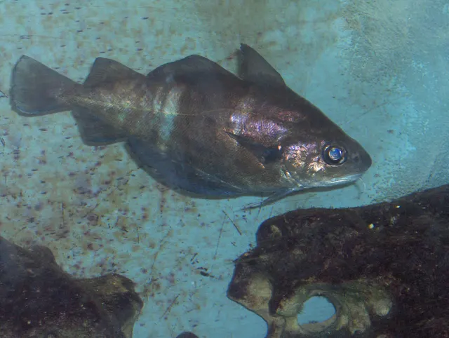 PoutingRegular local target2 placesBournemouth Pier, Swanage PierOver pier
Photo: Georges Jansoone JoJan, via Wikimedia Commons, CC BY-SA 3.0; resized

,_isla_de_Mouro,_Santander,_Espa%C3%B1a,_2019-08-15,_DD_55.jpg)

.jpg)

Also documented from the shore: Bull huss · Common sole · Edible crab · European lobster · Atlantic mackerel · Garfish · Whiting · Small-spotted catshark · Thornback ray · European plaice · Starry smooth-hound
What these strengths mean
- Regular local target
- Fishing sources describe this as a normal local target here, not merely as caught.
- Seasonal
- Well supported, and concentrated in part of the year rather than spread through it.
- Recorded here
- At least one credible public account of this species being caught here. That is all it means.
- How breadth is counted
- A fish documented at six marks is shown as six marks: breadth never raises the strength on its own. A fishery account describes the fishing; a recorded catch reports one specific catch. How evidence is weighed.
How people fish here
6 methods are recorded on the places documented here, counted from those places themselves rather than from what is practised in the country. Each opens a full guide to the technique.
Ledgering
Recorded at 7 places here, over headland, pier, bay, ledge.
Fishing a bait on the bottom held by a weight, with no float — the simplest way to fish at distance, in depth, or in wind.
Documented on the same ground: Ballan wrasse, Bull huss, Common sole, Conger eel, European flounder, European sea bass.
Float fishing
Recorded at 6 places here, over headland, ledge, pier.
Suspending a bait at a controlled depth beneath a buoyant indicator — the most visual, most controllable and most widely applicable method in angling.
Documented on the same ground: Ballan wrasse, Bull huss, Common sole, Conger eel, Edible crab, European lobster.
Spinning
Recorded at 6 places here, over headland, ledge, bay, tidal channel.
Casting an artificial lure and retrieving it so that it moves like something alive — the most direct form of lure fishing.
Documented on the same ground: Ballan wrasse, Bull huss, Conger eel, Edible crab, European flounder, European lobster.
Feathering and multi-lure traces
Recorded at 2 places here, over ledge, pier.
A string of small lures on droppers, worked in the water column — how most people in Britain and Ireland catch their first sea fish, and the method most likely to catch far more than anybody intended.
Documented on the same ground: Ballan wrasse, Common sole, Conger eel, European sea bass, Pouting, Atlantic mackerel.
Kayak fishing
Recorded at 1 place here, over tidal channel.
A platform rather than a technique: quiet, shallow-draught access to water no other craft reaches, bought at the price of exposure, and a discipline where the decision not to launch is part of the skill.
Documented on the same ground: European flounder, European sea bass.
Surfcasting
Recorded at 1 place here, over bay.
Casting heavy baited tackle from a beach into surf — a method defined by distance, by tide, and by reading water that all looks the same.
Documented on the same ground: European flounder, European sea bass.
These are the methods documented at the places FishingHQ holds here. A species listed beside a method is documented on the same ground, which is not the same as being taken that way — where a source establishes the method a fish was caught on, it is stated on that place’s own page. All fishing methods.
Baits and lures for these fish
The methods, baits and lures each of the fish above is commonly taken on, from that fish’s own page. This is what works for the fish, not a report of what people use on this particular water — local knowledge and the conditions on the day still decide.
Methods
- Drift fishing — for Pollack, Small-spotted catshark, European plaice
- Saltwater fly fishing — for European sea bass, Pollack, Garfish
- Recreational potting — for Edible crab, European lobster
- Crabbing with a line and a drop net — for Edible crab
- Deadbaiting — for Conger eel
- Drop shotting — for Ballan wrasse
- Freediving for lobster — for European lobster
- Jigging — for Pollack
Also: Popping and stickbaiting · Trolling
Baits
- Ragworm — for European sea bass, Ballan wrasse, European flounder, Pollack and 2 more
- Fish strip and cut bait — for Conger eel, Bull huss, Small-spotted catshark, Thornback ray
- Crab and shellfish — for European sea bass, Ballan wrasse, Starry smooth-hound
- Peeler crab — for European sea bass, European flounder, Starry smooth-hound
- Squid and cuttlefish — for Conger eel, Bull huss, Small-spotted catshark
- Lugworm — for Whiting, European plaice
- Sand eel — for European sea bass, Pollack
- Sea deadbaits — for Bull huss, Small-spotted catshark
Also: Prawns and shrimp
Lures
- Metal jigs — for European sea bass, Pollack, Atlantic mackerel
- Soft plastics — for European sea bass, Ballan wrasse, Pollack
- Jerkbaits — for European sea bass
- Jigs and jig heads — for Pollack
- Spinners — for Atlantic mackerel
- Streamers — for European sea bass
- Surface lures — for European sea bass
The fishing year here
The months the places and accounts under this area actually name, tightest season first. This is “observed in these months” rather than a season: a species whose months nobody recorded is not listed, because a gap in the evidence is not a year-round fishery.
- Atlantic mackerelJune to September
- PollackJune to September
- GarfishJune to September
- European lobsterJune to September
- WhitingNovember to February
- European sea bassMay to October
- Ballan wrasseMay to October
- European flounderOctober to March
What dominates
Rock and ledge fishing on the south side for wrasse, conger, bull huss and pollack, with light rock fishing a growing part of it. Bass lure fishing over the ledges and along the harbour entrance. Beach and surf fishing in Poole Bay and at Studland for bass, flatfish and smoothhound. Pier fishing at Swanage and Bournemouth. Small-boat and charter fishing out of Poole and Swanage over the banks and the wrecks. Mullet fishing in the harbour and around the piers, which has a specialist following here.
The water available
Purbeck and Portland limestone wave-cut platforms and ledges with deep water at their outer edge, backed by cliff. Kelp and rough ground below them. A sheltered sandy bay on the north side with shallow shelving beaches. One of the world's largest natural harbours discharging through a narrow entrance, with a strong tidal run and extensive intertidal flats, eelgrass and channels inside it. Chalk and clay cliffs at the eastern end. Offshore, banks and a heavy concentration of wreck.
How the rules are structured
English inshore sea fishing is administered by the Inshore Fisheries and Conservation Authority for the district, with national measures alongside, and bass in particular carries measures that have changed repeatedly. Piers and harbour structures are operational infrastructure whose access is a matter for the operator rather than a public right. Conservation designation is extensive on this coast and constrains collection and access in places independently of any fisheries measure. FishingHQ does not state what any current rule is: measures, designations and local byelaws change, and the answer differs by species and by stretch of coast.
Who to ask
- The relevant Inshore Fisheries and Conservation Authority for the district, which makes and enforces inshore byelaws including those on bait collection.
- The Marine Management Organisation, for national recreational sea fishing measures in English waters.
- The harbour authority or commissioners, for fishing from piers, breakwaters and harbour structures, where permission is a local matter and changes.
- Natural England and the relevant protected site body, where a designation affects access or collection.
- The Maritime and Coastguard Agency and the RNLI, for safety guidance on this coast.
Words you will meet
- Ledge
- A wave-cut limestone platform at the foot of a cliff, fished from its outer edge. On this coast the word is part of the mark name — Kimmeridge Ledges, Dancing Ledge — and it always implies a descent and a tide-dependent exit.
- The Run
- A narrow tidal channel with a hard stream through it. Used here for the Poole Harbour entrance at Sandbanks and, along the coast, for Mudeford Run at Christchurch.
Conditions and hazards
The ledges are the hazard and they are a serious one. Every south-side mark involves a descent from a cliff path onto a wet sloping limestone platform with deep water at its edge, and the exit is a climb. A swell that builds during a session turns a comfortable stance into a trap, and a person in the water at the foot of a cliff cannot be reached from the land.
Cold water is the second, and it is under-rated on a south-coast holiday shore: sea temperatures here stay low well into summer, and cold-water shock incapacitates in under a minute regardless of how well anybody swims.
Poole Bay is gentler but the harbour entrance is not. The stream through the Sandbanks gap runs hard, it is busy with commercial and leisure traffic, and it is not water to be in.
Some of what lives here
Fish recorded here that FishingHQ holds a reviewed photograph of. It is not a complete list of what The Purbeck coast and Poole Bay holds, and it is not a prediction that you will catch any of them — it is a way in to the ones we can show you.
- European sea bassA fast, predatory inshore fish that hunts in broken water and surf, and one of the most closely managed recreational species in European seas.
Photo: Julien Renoult, via Wikimedia Commons, CC BY 4.0; resized and trimmed to fit
- Ballan wrasseA long-lived rocky-ground resident that begins life female and may change sex — and the species that turned rock marks into a lure fishery.
Photo: Diego Delso, via Wikimedia Commons, CC BY-SA 4.0; resized and trimmed to fit
Places within this area
Publicly documented fishing geography. FishingHQ describes what the ground is; it does not say whether you may fish it, and every one of these sends that question to the body that holds the answer. Browse every place in this part of the world.
Who to ask before fishing any of these
FishingHQ does not know the current access position here. Shore angling in England is not rod-licensed, but access rights, landowner permission, local authority and harbour byelaws, national and inshore fisheries measures, and site designations all apply and all change. Check the current position with the relevant inshore fisheries and conservation authority, the harbour or local authority, and the landowner before going.
Kimmeridge Ledges
Ledge · Salt water
Flat shelves of Kimmeridge Clay and limestone running out from a shallow bay beneath dark shale cliffs, forming a series of parallel ledges separated by gullies. Distinctively flat, dark, slippery rock with dense weed and a rich, sheltered reef community.
South-facing and open to the Channel, but the bay itself is comparatively sheltered and the ledges break the swell before it reaches the shore.
Particular to this ground: slips, trips and falls, tides and being cut off, cold water shock.
Severe hazards of The Purbeck coast and Poole Bay apply here: cliffs and rock platforms.
Particular to this water: This ground carries conservation designations that constrain access, vehicles, bait collection and disturbance independently of any fishing rule.
Poole Harbour entrance and Sandbanks
Tidal channel · Salt water
The mouth of one of the largest natural harbours in the world, constricted to a few hundred metres between sand spits, scoured deep, with a double high water and a stream that runs for far longer on the ebb than the flood.
Severe hazards of The Purbeck coast and Poole Bay apply here: cliffs and rock platforms, cold water shock, tides and being cut off.
Swanage Pier
Pier · Salt water
A timber pleasure pier in a sheltered east-facing bay under the Purbeck chalk, standing over clean sand and weed with limestone ledges at both ends of the bay.
Severe hazards of The Purbeck coast and Poole Bay apply here: cliffs and rock platforms, cold water shock, tides and being cut off.
Bournemouth Pier
Pier · Salt water
A pier running out over flat clean sand in the middle of Poole Bay, with no rough ground for miles either side and the water shallow all the way to the end. Depth by walking rather than by casting.
Open south into Poole Bay; the bay itself is sheltered by the Purbeck ridge and the Island.
Severe hazards of The Purbeck coast and Poole Bay apply here: cliffs and rock platforms, cold water shock, tides and being cut off.
Particular to this water: This is an owned and operated structure. Whether angling is allowed on it, when, from where and on what terms is the operator's decision, is frequently seasonal, and changes without notice.
Studland Bay
Bay · Salt water
A shallow sandy bay behind Handfast Point, floored with sand and one of the largest seagrass beds on the English south coast, with the Poole Harbour entrance at its western end. Warm, shallow, sheltered water over eelgrass.
Sheltered from the prevailing south-westerly by the Purbeck headland; open north-east.
Severe hazards of The Purbeck coast and Poole Bay apply here: cliffs and rock platforms, cold water shock, tides and being cut off.
Particular to this water: The seagrass beds in this bay are a designated marine protected feature with their own management measures, including restrictions on anchoring, which are set by the authorities rather than described here.
Peveril Point
Headland · Salt water
A low reef of upturned Purbeck limestone beds running out from the south side of Swanage Bay, uncovering as a line of jagged ledges with a tide race over the end. Shallow, sharp and awkward, with the race doing the work.
Open east and south-east; the point itself shelters Swanage Bay from the south.
Particular to this ground: cliffs and rock platforms, tides and being cut off.
Severe hazards of The Purbeck coast and Poole Bay apply here: cold water shock.
Dancing Ledge
Ledge · Salt water
A flat quarried limestone shelf at sea level below the Purbeck cliffs, with the old quarry pool cut into it and deep water immediately off the edge. Reached by a walk down from the clifftop and by nothing else.
Open south into the Channel with the cliff behind and no shelter on the ledge itself.
Particular to this ground: cliffs and rock platforms, cold water shock, cliffs and rock platforms.
Severe hazards of The Purbeck coast and Poole Bay apply here: tides and being cut off.
St Alban's Head
Headland · Salt water
The highest headland on the Purbeck coast, with a stepped quarried undercliff below it, boulder ground at the foot and a tide race running off the point. A long steep descent and a longer climb out.
Open south and west into the Channel from the highest ground on the coast.
Particular to this ground: cliffs and rock platforms, cold water shock, cliffs and rock platforms.
Severe hazards of The Purbeck coast and Poole Bay apply here: tides and being cut off.
Said of this area as a whole
These are statements other people have published about fishing here, summarised and attributed. Where one is a catch, it is that angler’s own report of one day; a recommendation is not a catch, and neither is a forecast.
Getting there, as described
Dorset Council states that the Environment Agency owns the fishing rights on the tidal Frome and Piddle from Wareham down to the posts marking the entrance to Poole Harbour, and that permits come from the Agency. The page is undated, so the Agency is the body to ask about what applies now.
The body responsible for the place: Dorset Council.
Said of named places here that have no page of their own
Statements other people have published about fishing at these places, summarised and attributed. They are not catch records, a recommendation is not a forecast, and none of them says whether you may fish there or how to reach it safely.
Poole Harbour entrance and Sandbanks
Getting there, as described
The regional guide describes the harbour as a bass nursery area in which fish should be returned. The nursery area's boundaries, dates and rules are set in regulation and are the fisheries authority's to state.
Fish named: European sea bass.
A published angling guide: British Sea Fishing.
Safety
Cliffs and rock platforms — Can cause serious injury or death
Low limestone and shale ledges reached by a descent from a cliff top, fished from a platform that is wet, sloping seaward and lower than it looks from above. A sea that was manageable on arrival can put water across the whole platform, and the way back up is a climb rather than a walk.
What reduces it: Look at the state of the sea from the top before committing to the descent, and look at the forecast for the whole session rather than for the hour. Know where the exit is and how long it takes. Do not fish a ledge alone. Wear a buoyancy aid: a person in the water at the foot of a cliff cannot be reached quickly from the land.
Worse when:
- A rising swell during the session, so the descent was safe and the ascent is not
- Wet weed and algae on the platform, which are as slippery as ice on limestone
- A big spring tide, which reaches ledges that a neap leaves dry
Cold water shock — Can cause serious injury or death
Sea temperatures around these coasts stay low enough for most of the year that sudden immersion causes involuntary gasping and rapid loss of useful movement in the hands and arms. Swimming ability makes very little difference to the outcome in the first minute, which is the minute that decides it.
What reduces it: Wear a buoyancy aid on any rock, pier or harbour mark, not only on a boat. If you go in, float on your back and let the gasping pass before trying to do anything. Get out and get warm quickly — the danger continues after the water.
Worse when:
- Spring and early summer, when the air feels warm and the sea has not caught up
- Fishing alone, where nobody raises the alarm
- Heavy clothing and waders, which make self-rescue much harder
Tides and being cut off — Can cause serious injury or death
Ledges, sandbanks and beach sections reached at low water and cut off by a flooding tide that comes in behind rather than towards. The route back disappears before the standing ground does, which is why people are caught out on ground that is still dry.
What reduces it: Work out the time of the tide before going, not after arriving. Identify the point at which the way back closes and set an alarm for it. Never rely on being able to wade a channel that was walkable an hour earlier.
Worse when:
- Big spring tides, which flood faster and reach further
- Onshore wind and low pressure, which raise the water above the predicted height
- Fog or darkness, which remove the visual cues people navigate back by
Precautions that always apply here
- Wear a buoyancy aid or lifejacket. Cold water incapacitates strong swimmers within a minute, long before swimming ability matters.
- Check the tide before you go and know your exit route. Being cut off is the commonest way a shore session becomes a rescue.
- Tell somebody where you are going and when you expect to be back.
- Carry a charged phone in a waterproof case, or another means of calling for help.
Check the rules before you fish
Fishing laws, bylaws, access rules, seasons, bait restrictions and permitted methods vary by location and can change. Check the current rules from the relevant authority and the water you intend to fish before fishing.
Check with:
- Current national or regional law for where you are fishing
- Current local bylaws
- The relevant fisheries authority
- The landowner, club or fishery whose water it is
- Any restrictions specific to the species or the method you intend to use
Where to go next
What swims here
- Ballan wrassePurbeck and Portland limestone cut into wave-cut platforms with kelp and broken ground at their edge is the species' habitat exactly, and the ledges are where a shore angler reaches it.
- European sea bassBoth halves of this coast suit it for opposite reasons: the limestone ledges on the south side put deep water and broken ground within a cast, and the Poole Harbour entrance concentrates prey through a narrow gap on every tide. Bass are a hydraulics fish and this coast supplies two different kinds of it.
More fishing regions
Not related to this page — just the rest of the section. There is little else joined to this subject yet, and a short page should still lead somewhere.
Sources and evidence
- General angling website restatements of established technique — Various (Credible secondary source)Relied on for: Widely restated descriptions of the Dorset shore marks, their ground and the species reported from them, recorded as consensus rather than as scholarship.Background and mechanism onlyCitation checked — the work exists and is described correctly
Why the 2 connections on this page are here, and the sources
What swims here
Backed by research — 2 connections
Supported by peer-reviewed research or fisheries science. The sources are listed and can be checked.
Ballan wrasse
A claim that a coast or region contains the ground and conditions this species is associated with. It is a distributional statement about the world, it rests on the reference literature and on the institute that surveyed it, and it deliberately asserts nothing about access, permission or catch.
- The Fishes of the British Isles and North-West Europe — Macmillan, 1969 (Reference work)Relied on for: Distribution and habitat association of the marine fishes of the British Isles and north-west Europe, including which coasts and ground types a species occupies.States this directlyCitation checked — the work exists and is described correctly
- FishBase: a global information system on fishes — Froese, R. and D. Pauly, eds. — FishBase Consortium (Scientific institute)Relied on for: Recorded distribution, depth range and habitat association for the species named.States this directlyPassage read and verified
European sea bass
A claim that a coast or region contains the ground and conditions this species is associated with. It is a distributional statement about the world, it rests on the reference literature and on the institute that surveyed it, and it deliberately asserts nothing about access, permission or catch.
- The Fishes of the British Isles and North-West Europe — Macmillan, 1969 (Reference work)Relied on for: Distribution and habitat association of the marine fishes of the British Isles and north-west Europe, including which coasts and ground types a species occupies.States this directlyCitation checked — the work exists and is described correctly
- FishBase: a global information system on fishes — Froese, R. and D. Pauly, eds. — FishBase Consortium (Scientific institute)Relied on for: Recorded distribution, depth range and habitat association for the species named.States this directlyPassage read and verified
How FishingHQ labels evidence is explained in the evidence policy.