Outer Hebrides
Fishing regions · Last reviewed 2026-08-12
A long Atlantic-facing chain with the machair shell-sand coast on one side and a rock-and-loch landscape on the other, and some of the clearest inshore water in Britain.
Safety: cliffs and rock platforms — can cause serious injury or death. 6 more points apply here.
Being listed here is not permission to fish. What that meansClose
Access, fishing rights, seasons, licences, local bylaws and permitted methods vary and can change. Check current access, permission, local regulations, closures and restrictions before you travel or fish. FishingHQ describes what the ground is and names who holds the answer; it does not hold the answer itself.
Find the authority for a jurisdiction · What FishingHQ does and does not cover
The Outer Hebrides run for roughly a hundred and thirty miles along the Atlantic edge of Scotland, and the chain is markedly asymmetric. The west coast faces the open Atlantic and is fringed with white shell-sand beaches backed by machair — a fertile, lime-rich grassland formed from wind-blown shell sand and found almost nowhere else. The east coast is rock, sea loch and skerry, sheltered by the islands themselves.
That asymmetry is the fishing. A single day can offer surf beach on one side and sheltered rock and loch on the other, and the choice between them is made on wind direction rather than on preference. Very few places in Britain offer that within so short a distance.
The water is exceptionally clear. Shell sand, low nutrient input, no significant industry and little river sediment produce inshore visibility that surprises visitors, and it has two practical consequences: sight-based methods work unusually well, and fish see tackle unusually well too.
The islands are also a freshwater fishery of international standing. The interior is a scatter of thousands of lochs holding brown trout, with sea trout and salmon running the short river systems, and the machair lochs in particular are lime-rich and productive in a way most Scottish hill lochs are not.
The fish community inshore is northern and clean-ground: pollack, saithe, cod, mackerel, wrasse and flatfish, with skates and rays on deeper mixed ground and a historic commercial fishery for shellfish that remains significant.
What fishing here is like
A long, exposed, sparsely populated Atlantic chain with an unusually clean and clear inshore sea, offering surf beach and sheltered rock within a few miles of each other and a freshwater loch fishery of genuine international standing alongside. The defining practical fact is the wind: with an Atlantic-facing west coast and a sheltered east, there is nearly always a fishable side, and choosing it correctly is the local skill.
The culture is crofting and sea-working rather than sport-fishing, with a long tradition of taking fish and shellfish for the table, and a Gaelic-speaking community whose place names carry a great deal of the geography.
What you can target here
One entry per fish, grouped by how you would be fishing — because the answer is a different one from the rocks and from a boat. Each entry says how strongly the sources support it and how much evidence sits behind it. These are documented catches, not a forecast, and none of it is a statement that you may fish any particular ground.
From the shore · 7
 PollackRegular local target3 placesEoropie beach, Griminish Pier, Kallin HarbourOver harbour wall, pier, surf beachAround Jun–Sept
 European flounderRegular local target2 placesEoropie beach, The South Uist machair beachesOver surf beach
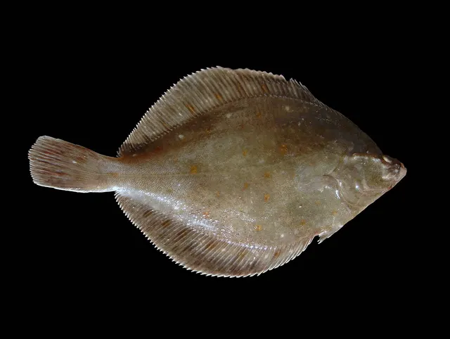 European plaiceRegular local target2 placesEoropie beach, The South Uist machair beachesOver surf beach
 Atlantic mackerelSeasonal3 placesEoropie beach, Griminish Pier, Kallin HarbourOver harbour wall, pier, surf beachAround Jun–Sept
 European sea bassSeasonal1 placeThe South Uist machair beachesOver surf beachAround Jun–Sept
 Thick-lipped grey mulletSeasonal1 placeThe South Uist machair beachesOver surf beachAround Jun–Sept
Also documented from the shore: Turbot
What these strengths mean
- Regular local target
- Fishing sources describe this as a normal local target here, not merely as caught.
- Seasonal
- Well supported, and concentrated in part of the year rather than spread through it.
- Recorded here
- At least one credible public account of this species being caught here. That is all it means.
- How breadth is counted
- A fish documented at six marks is shown as six marks: breadth never raises the strength on its own. A fishery account describes the fishing; a recorded catch reports one specific catch. How evidence is weighed.
How people fish here
7 methods are recorded on the places documented here, counted from the records themselves rather than from what is practised in the country. Each opens a full guide to the technique.
Spinning
Recorded at 7 places here, over harbour wall, surf beach, pier, sea loch.
Casting an artificial lure and retrieving it so that it moves like something alive — the most direct form of lure fishing.
Documented on the same ground: European flounder, European plaice, Pollack, Atlantic mackerel, European sea bass, Thick-lipped grey mullet.
Float fishing
Recorded at 6 places here, over harbour wall, beach, pier, sea loch.
Suspending a bait at a controlled depth beneath a buoyant indicator — the most visual, most controllable and most widely applicable method in angling.
Documented on the same ground: Atlantic mackerel, Pollack.
Kayak fishing
Recorded at 4 places here, over beach, harbour wall, sea loch, sound or strait.
A platform rather than a technique: quiet, shallow-draught access to water no other craft reaches, bought at the price of exposure, and a discipline where the decision not to launch is part of the skill.
Jigging
Recorded at 3 places here, over harbour wall, sea loch, sound or strait.
Working a weighted lure with a rising-and-falling motion, usually vertically, so it behaves like a wounded or fleeing baitfish.
Ledgering
Recorded at 3 places here, over surf beach, beach.
Fishing a bait on the bottom held by a weight, with no float — the simplest way to fish at distance, in depth, or in wind.
Documented on the same ground: European flounder, European plaice, Pollack, Atlantic mackerel, European sea bass, Thick-lipped grey mullet.
Feathering and multi-lure traces
Recorded at 2 places here, over harbour wall, pier.
A string of small lures on droppers, worked in the water column — how most people in Britain and Ireland catch their first sea fish, and the method most likely to catch far more than anybody intended.
Documented on the same ground: Atlantic mackerel, Pollack.
Surfcasting
Recorded at 2 places here, over surf beach.
Casting heavy baited tackle from a beach into surf — a method defined by distance, by tide, and by reading water that all looks the same.
Documented on the same ground: European flounder, European plaice, Pollack, Atlantic mackerel, European sea bass, Thick-lipped grey mullet.
These are the methods documented at the places FishingHQ holds here. A species listed beside a method is documented on the same ground, which is not the same as being taken that way — where a source establishes the method a fish was caught on, it is stated on that place’s own page. All fishing methods.
The fishing year here
The months the records under this area actually name, tightest season first. This is “observed in these months” rather than a season: a species whose months nobody recorded is not listed, because a gap in the evidence is not a year-round fishery.
- PollackJune to September
- Atlantic mackerelJune to September
- European sea bassJune to September
- Thick-lipped grey mulletJune to September
What dominates
Shore fishing from surf beach on the west and from rock and skerry on the east. Small-boat fishing in the sea lochs and sheltered sounds. Brown trout fishing on the machair and hill lochs, which is the fishery the islands are best known for internationally, with sea trout and salmon on the short river systems. Shellfish and crustacean gathering and creel fishing, both traditional and commercial. Spearfishing is possible but constrained by cold water and exposure.
The water available
White shell-sand surf beaches backed by machair on the entire Atlantic-facing west coast. Rock, skerry, sea loch and sheltered sound on the east. Extensive kelp on hard ground. Thousands of freshwater lochs across the interior, the machair ones lime-rich and productive, the hill ones acid and less so. Short, spate-driven river systems connecting them to the sea.
How the rules are structured
Sea angling from the shore in Scotland requires no rod licence, which is a framework difference from England and Wales rather than an absence of rules — minimum sizes, protected areas, shellfish classification and crustacean regulations all apply. Freshwater fishing is a permit fishery: the lochs and rivers are owned or managed by estates, angling clubs and community bodies, and permission is obtained locally and is genuinely required. Shellfish gathering is subject to harvesting-area classification and closure on public health grounds, administered separately from fisheries rules. Establish all of this locally and currently. FishingHQ does not state what any current rule is, and nothing in this page is a statement of what is permitted today.
Who to ask
- The Scottish fisheries and marine authorities, for sea fisheries rules, sizes and protected areas
- The relevant estate, angling club or community body, for freshwater permits — which are required and are obtained locally
- The local authority environmental health service, for shellfish harvesting classification and closures
- Local clubs and tackle shops, which in a sparsely populated island chain are the practical route to current access information
Words you will meet
- Machair
- The lime-rich, shell-sand grassland behind the Atlantic beaches, found in quantity almost nowhere outside the Hebrides and western Ireland. Machair lochs are productive in a way ordinary Scottish hill lochs are not, and the word describes the whole coastal system.
- Skerry
- A small rocky island or reef, frequently awash. Skerries structure the sheltered eastern coast and are both productive ground and a navigation hazard.
- Sea loch
- A long sheltered marine inlet. Sea lochs on the east coast provide fishable water in conditions that make the Atlantic side impossible.
- Spate
- A river in flood after rain. The island rivers are short and spate-driven, so salmon and sea trout run in response to rainfall rather than on a calendar.
Conditions and hazards
The Atlantic coast takes full ocean swell with nothing between it and North America, and the surf beaches that make the west coast attractive are the same beaches where rip currents and heavy shore dumps occur. Swell arrives from distant weather with no local warning.
The islands are exposed and the weather changes quickly. Mobile coverage is good in settled areas and unreliable on much of the coast and in the interior, so a means of calling for help should not be assumed to work everywhere.
Water temperature is low year-round and immersion is serious in any month. Distances between settlements are substantial and help is not close on much of the coast, which raises the consequence of any incident.
The interior loch fishing puts people a long way from a road, frequently alone, on ground with no shelter.
Crofting, Gaelic and a fishing life that was never only fishing
The Outer Hebrides' fishing culture is inseparable from crofting, and understanding that explains its shape.
THE CROFT AND THE BOAT WERE ONE LIVELIHOOD. A croft on machair or peat could not support a household alone, and neither could a small boat; the two together could. That combination produced a population with general competence on the water rather than a separate fishing class, and it is why fishing knowledge here is domestic rather than professional in character.
GAELIC IS A LIVING LANGUAGE HERE and it carries the fishing vocabulary. Place names, ground names and fish names in Gaelic encode a great deal of practical information about where things are and what they are like, and the loss of that language would take real knowledge with it.
THE SABBATH IS STILL OBSERVED in much of the islands, and it is a practical fact for a visiting angler as well as a cultural one. Planning a week without accounting for it is a common visitor mistake.
THE TROUT AND SALMON FISHERIES ARE ESTATE-BASED IN PART, with the machair lochs and the salmon systems historically attached to sporting estates, and community land ownership across substantial parts of the islands has changed how some of that is administered.
SEA ANGLING IS INFORMAL AND EXCELLENT. Small-boat and shore fishing for pollack, cod, mackerel and ray, from a coast with very little pressure on it, is an everyday activity rather than an organised sport.
AND THE ISOLATION IS A CULTURAL FACT AS WELL AS A GEOGRAPHIC ONE. Weather closes ferries, distances are long, and self-reliance is assumed of visitors as much as of residents.
What experienced anglers do — why, and the sources (2)
Widely and independently recommended by experienced anglers and specialist sources. This is real angling knowledge, not proof: controlled evidence for it is limited, and FishingHQ records it as convention rather than as a demonstrated effect.
- General angling website restatements of established technique — Various (Credible secondary source)Relied on for: Widely restated practice associating this discipline or technique with this place, recorded as practitioner consensus rather than as tested fact.Background and mechanism onlyCitation checked — the work exists and is described correctly
- Fishers' Craft and Lettered Art: Tracts on Fishing from the End of the Middle Ages — University of Toronto Press, 1997 (Scientific literature)Relied on for: That fishing traditions develop around the water and fish available to them, and the historical method of reading such traditions from their documentary record.States this directlyCitation checked — the work exists and is described correctly
Machair loch, sea loch and Atlantic shore
The Outer Hebrides support three distinct fisheries and the geology sorts them cleanly.
MACHAIR LOCH FLY FISHING IS THE ISLANDS' SPECIALITY. On the Atlantic side, shell sand blown inland has created machair — a calcareous grassland — and the lochs sitting in it are alkaline, fertile and shallow, quite unlike the acid peat lochs on the eastern side of the same islands. They hold wild brown trout in numbers and condition, and traditional loch-style fly fishing from a drifting boat is the method.
THE PEAT LOCHS ARE THE OTHER FRESHWATER, and they are honest about being different: acid, dark, low in productivity, holding smaller trout in larger numbers. They are fished with the same methods for a different experience.
SEA TROUT AND SALMON FISHING works the systems that connect loch chains to the sea, and the west coast sea trout fishery has real quality where the runs remain.
SEA LOCH BOAT FISHING on the eastern, sheltered side works deep water in narrow inlets for pollack, cod and ray.
ATLANTIC SHORE FISHING on the western beaches and rock is exposed, physically demanding and lightly pressured, with bass at the northern edge of their range and a general shore fishery for ray, dogfish and flatfish over clean sand.
SHELLFISH CREELING IS THE COMMERCIAL MAINSTAY, for lobster, crab and prawns, worked from small boats out of a large number of small harbours.
AND THE ASYMMETRY IS THE ORGANISING PRINCIPLE. West side: Atlantic, exposed, shell sand, fertile lochs. East side: sheltered, rocky, peat, sea lochs. The same island offers two different fishing weeks depending which coast the wind allows.
What experienced anglers do — why, and the sources (2)
Widely and independently recommended by experienced anglers and specialist sources. This is real angling knowledge, not proof: controlled evidence for it is limited, and FishingHQ records it as convention rather than as a demonstrated effect.
- General angling website restatements of established technique — Various (Credible secondary source)Relied on for: Widely restated practice associating this discipline or technique with this place, recorded as practitioner consensus rather than as tested fact.Background and mechanism onlyCitation checked — the work exists and is described correctly
- Fishers' Craft and Lettered Art: Tracts on Fishing from the End of the Middle Ages — University of Toronto Press, 1997 (Scientific literature)Relied on for: That fishing traditions develop around the water and fish available to them, and the historical method of reading such traditions from their documentary record.States this directlyCitation checked — the work exists and is described correctly
Wild trout, sea trout and a sea that is lightly fished
The species picture here is dominated by salmonids in fresh water and by a general Atlantic shore and inshore fauna in salt.
WILD BROWN TROUT ARE THE FRESHWATER FISHERY and they come in two distinct qualities. Machair loch fish grow well on the alkaline productive water and reach good sizes; peat loch fish are smaller, more numerous and darker. Both are genuinely wild and self-sustaining, which is increasingly rare.
SEA TROUT RUN THE CONNECTED SYSTEMS, and where the runs remain they support a quality fishery in the loch chains and estuaries. Sea trout populations across the west of Scotland have had a difficult recent history and honest accounts say so rather than repeating a historic reputation.
ATLANTIC SALMON RUN A NUMBER OF THE ISLAND SYSTEMS, in smaller numbers than the mainland rivers, and are fished under the Scottish conservation framework.
ARCTIC CHAR OCCUR IN SOME OF THE DEEPER LOCHS, as a relict population at the southern edge of their range, and they are a genuine curiosity of the islands' fresh water.
POLLACK, COD, LING AND COALFISH occupy the rocky ground and sea lochs, and pollack in particular are abundant over the kelp and rock of the sheltered eastern coast.
THORNBACK RAY, SPURDOG AND FLATFISH work the cleaner ground, and mackerel arrive inshore in the warmer months.
EUROPEAN LOBSTER, BROWN CRAB AND LANGOUSTINE are the commercial catch and are also the reason the inshore seabed here matters economically.
AND THE COAST IS LIGHTLY FISHED RECREATIONALLY, which is the single most attractive fact about it: a shore fishery with genuine quality and almost no pressure is unusual anywhere in Britain.
Backed by research — why, and the sources (2)
Supported by peer-reviewed research or fisheries science. The sources are listed and can be checked.
- The Fishes of the British Isles and North-West Europe — Macmillan, 1969 (Reference work)Relied on for: Distribution, habitat association, depth and ground preference of fishes in British and north-west European waters.States this directlyCitation checked — the work exists and is described correctly
- FishBase: a global information system on fishes — Froese, R. and D. Pauly, eds. — FishBase Consortium (Scientific institute)Relied on for: Distribution, habitat association and depth range recorded for the species.Background and mechanism onlyPassage read and verified
Machair, loch and the Gaelic names for ground
The vocabulary here is Gaelic and Norse in layers, and several words name things a visitor will otherwise misread.
MACHAIR NAMES THE CALCAREOUS GRASSLAND behind the Atlantic beaches, formed from wind-blown shell sand. It is not simply a dune or a meadow: it is a specific and internationally rare habitat, and its chemistry is what makes the lochs sitting in it productive. A machair loch and a peat loch a few miles apart are different fisheries for this reason.
LOCH COVERS BOTH FRESH AND SALT WATER in Scottish usage, which catches out visitors. A sea loch is a fjord-like marine inlet; a freshwater loch is a lake. The word alone does not tell you which, and the local name usually does.
SGEIR NAMES A ROCK OR SKERRY, frequently one that covers and uncovers with the tide. Coastal place names are full of them and they are simultaneously fishing marks and navigational hazards.
CAOLAS NAMES A NARROW STRAIT OR KYLE between islands, where tidal flow concentrates. As everywhere on FishingHQ, flow through a narrows is a fishing feature.
TRAIGH NAMES A BEACH, and the Atlantic traighean of the west side are the shell-sand beaches that produce the machair and the shore fishing both.
CUDDY AND SAITHE NAME THE COALFISH at different life stages, as sillock and cuith do in Orkney, and the existence of stage-specific names is again a marker of how much the fish mattered as food.
AND MOST OF THE PRODUCTIVE GROUND HAS A GAELIC NAME rather than an English one, which means that reading a map here is a partial exercise and that local knowledge is held in a language a visitor probably does not speak.
What experienced anglers do — why, and the sources (2)
Widely and independently recommended by experienced anglers and specialist sources. This is real angling knowledge, not proof: controlled evidence for it is limited, and FishingHQ records it as convention rather than as a demonstrated effect.
- General angling website restatements of established technique — Various (Credible secondary source)Relied on for: Widely restated practice associating this discipline or technique with this place, recorded as practitioner consensus rather than as tested fact.Background and mechanism onlyCitation checked — the work exists and is described correctly
- Fishers' Craft and Lettered Art: Tracts on Fishing from the End of the Middle Ages — University of Toronto Press, 1997 (Scientific literature)Relied on for: That fishing traditions develop around the water and fish available to them, and the historical method of reading such traditions from their documentary record.States this directlyCitation checked — the work exists and is described correctly
Clearance, kelp, herring and community ownership
The Outer Hebrides' fishing history is bound up with land history in a way that is unusual and consequential.
THE KELP INDUSTRY WAS THE FIRST INDUSTRIAL USE OF THE SHORE. In the late eighteenth and early nineteenth centuries, seaweed was burned to produce alkali for glass and soap, and the industry supported a large population on the coast. Its collapse when cheaper sources appeared left communities that had been settled on the shore for that purpose with no economy.
THE CLEARANCES FOLLOWED, and people were moved to coastal townships or emigrated. The resulting settlement pattern — crofting townships on the shore, on land too poor to farm alone — is why a fishing-and-crofting livelihood became the norm.
THE HERRING FISHERY WAS THE NINETEENTH-CENTURY EMPLOYER, with the islands supplying boats and crews and, particularly, the women who gutted and packed the catch following the fishery round the coast. Its collapse removed that.
THE SEA TROUT AND SALMON FISHERIES were substantially estate assets, let for sport, and the relationship between estate sporting rights and crofting communities is a long-running theme in the islands' history.
COMMUNITY LAND OWNERSHIP IS THE MODERN CHAPTER. Substantial areas of the islands are now in community ownership following buyouts, which has changed who administers some fishing rights and how revenue from them is used. It is one of the more significant land reform developments in Britain and it directly affects fisheries access.
AND THE SHELLFISH FISHERY IS THE CURRENT ECONOMY, worked from many small harbours, exporting live to European markets, and vulnerable to changes in that trade in ways that have nothing to do with the sea.
Official guidance — why, and the sources (2)
Stated by a fisheries authority, scientific institute or recognised angling body. Authoritative, but summarising rather than demonstrating.
- Fishers' Craft and Lettered Art: Tracts on Fishing from the End of the Middle Ages — University of Toronto Press, 1997 (Scientific literature)Relied on for: The historical development of fishing practice and its transmission, and the method of reading a fishing tradition from its documentary record.States this directlyCitation checked — the work exists and is described correctly
- Code of Conduct for Responsible Fisheries — Food and Agriculture Organization of the United Nations, Rome, 1995 (Standards body)Relied on for: Principles for fisheries management including the treatment of traditional, small-scale and shared fisheries, against which historical arrangements can be read.Background and mechanism onlyCitation checked — the work exists and is described correctly
No rod licence, but permission still matters
The regulatory position in the Outer Hebrides is Scottish, with island-specific features around access.
THERE IS NO ROD LICENCE FOR SEA ANGLING IN SCOTLAND, and none for brown trout either. What exists instead is a system in which the right to fish fresh water belongs to the owner of the fishery, so the practical question is permission rather than licensing.
PERMITS ARE ISSUED BY ESTATES, ANGLING ASSOCIATIONS AND COMMUNITY BODIES, and on these islands the mix includes community-owned land where the administration has changed within recent decades. The first question about any loch is who administers it.
SALMON AND SEA TROUT ARE SEPARATELY AND MORE TIGHTLY REGULATED, with a national conservation framework that assesses salmon stocks and can restrict killing on particular rivers, and with statutory seasons.
SEA FISHING IS SUBJECT TO NATIONAL AND EUROPEAN MEASURES on minimum sizes, prohibited species and gear, administered through the marine directorate, and to inshore fisheries arrangements involving regional groups.
SHELLFISH CARRY THEIR OWN REGIME: size limits, gear and licensing for commercial take, and a separate public health regime of sanitary classification and biotoxin monitoring for anything filter-feeding.
MARINE PROTECTED AREAS AND EUROPEAN HABITAT DESIGNATIONS cover significant areas of the islands' waters, including sea lochs and machair systems, and they constrain activity independently of fisheries rules.
AND FISHINGHQ DOES NOT STATE WHAT ANY OF THIS CURRENTLY PERMITS. Naming the estate, the association, the community body or the marine directorate is the durable answer.
Official guidance — why, and the sources (2)
Stated by a fisheries authority, scientific institute or recognised angling body. Authoritative, but summarising rather than demonstrating.
- Code of Conduct for Responsible Fisheries — Food and Agriculture Organization of the United Nations, Rome, 1995 (Standards body)Relied on for: Principles for the management of fisheries, including licensing, closed seasons, size limits and the treatment of small-scale and shared stocks.States this directlyCitation checked — the work exists and is described correctly
- Good Fish Guide — Marine Conservation Society (Conservation authority)Relied on for: Assessment of fisheries and the management measures applied to them, including the instruments used and their purpose.Background and mechanism onlyCitation checked — the work exists and is described correctly
Two coasts, machair sand and water you can see the bottom through
The Outer Hebrides are markedly asymmetric, and the asymmetry is the fishing.
THE WEST COAST faces the open Atlantic with nothing between it and North America. It is fringed almost continuously with white shell-sand beaches, and behind them lies machair — a fertile, lime-rich grassland formed from wind-blown shell sand, found in quantity almost nowhere outside these islands and western Ireland. The beaches are surf beaches in the full sense, and the swell reaching them is generated by weather thousands of miles away.
THE EAST COAST is rock, skerry and sea loch, sheltered by the islands themselves. It is a completely different proposition: sheltered water, complex ground, and fishable conditions when the west is unapproachable.
THE PRACTICAL CONSEQUENCE is the local skill. With an exposed side and a sheltered side a few miles apart, there is nearly always a fishable coast, and choosing it correctly on the day's wind is what separates a good visitor from a frustrated one. Very few places in Britain offer that within so short a distance.
THE WATER IS EXCEPTIONALLY CLEAR. Shell sand rather than silt, low nutrient input, almost no industry and little river sediment produce inshore visibility that genuinely surprises people. That has two consequences and they pull against each other: sight-based methods work unusually well, and the fish see tackle unusually well too.
AND THE INTERIOR IS WATER. The islands hold thousands of freshwater lochs — the machair ones lime-rich and productive in a way ordinary Scottish hill lochs are not, the peat ones acid and less so — connected to the sea by short, steep, spate-driven river systems. That freshwater fishery has an international reputation and it exists because of the same shell sand that built the beaches.
Backed by research — why, and the sources (2)
Supported by peer-reviewed research or fisheries science. The sources are listed and can be checked.
- General angling website restatements of established technique — Various (Credible secondary source)Relied on for: Widely restated local fishing character and practice for these waters, recorded as practitioner consensus rather than as tested fact.Background and mechanism onlyCitation checked — the work exists and is described correctly
- RNLI water safety guidance: cold water shock and Float to Live — Royal National Lifeboat Institution (Water-safety or diver-training authority)Relied on for: That tidal streams, swell from distant weather and cold-water immersion are the principal hazards to shore and small-craft users on exposed coasts.States this directlyPassage read and verified
Choosing a coast: what the wind decides here
In most places the weather decides whether to fish. Here it decides where, and that difference organises the whole fishing year.
THE RULE IS SIMPLE AND THE APPLICATION IS NOT. A westerly puts the Atlantic coast out of reach and makes the eastern sea lochs and skerries comfortable. An easterly does the reverse, and the west coast beaches become fishable surf rather than unapproachable swell. What complicates it is that swell and wind are not the same thing: a big Atlantic swell can be running onto the west coast in flat calm, generated by a depression that passed days ago and hundreds of miles away, and a visitor reading the wind forecast alone will misjudge it.
SO THE PRACTICAL PLANNING TOOL IS THE SWELL FORECAST, and the habit worth acquiring is checking it before deciding which side of the islands to drive to.
THROUGH THE YEAR. The sea fishery follows the ordinary northern pattern: mackerel and the summer species arrive as the water warms and leave as it cools, with the season shorter and later than in the south-west of Britain. Winter shore fishing is a cold, dark and often unapproachable proposition on the Atlantic side and remains possible in the sheltered east.
THE FRESHWATER SEASON is defined by rainfall rather than by date. The river systems are short and steep, so salmon and sea trout run in response to spate rather than on a calendar, and a dry spell holds fish in the sea while a wet week moves everything at once. Loch fishing for brown trout is less rainfall-dependent and is at its best through the long northern summer days, when the light lasts far into what would be night further south.
AND THE LIGHT IS PART OF THE SEASON. At this latitude the summer day is effectively unlimited and the winter one barely exists, which changes the shape of a session more than any tackle decision does.
Backed by research — why, and the sources (2)
Supported by peer-reviewed research or fisheries science. The sources are listed and can be checked.
- General angling website restatements of established technique — Various (Credible secondary source)Relied on for: Widely restated local fishing character and practice for these waters, recorded as practitioner consensus rather than as tested fact.Background and mechanism onlyCitation checked — the work exists and is described correctly
- RNLI water safety guidance: cold water shock and Float to Live — Royal National Lifeboat Institution (Water-safety or diver-training authority)Relied on for: That tidal streams, swell from distant weather and cold-water immersion are the principal hazards to shore and small-craft users on exposed coasts.States this directlyPassage read and verified
Ordinary hazards, and the arithmetic that comes after them
The individual dangers here are not exotic. Atlantic swell on the west, cold water in every month, wind, and a lot of walking. What is different is what happens in the hour after something goes wrong, and that changes which precautions are worth taking rather than merely how carefully to take them.
THE CONSEQUENCE MULTIPLIER IS DISTANCE. Settlements are far apart, roads are few and long, mobile coverage is reliable in inhabited areas and unreliable on much of the coast and across the interior, and a great deal of the fishing here is done alone — a person on a hill loch a long way from a road is a normal Hebridean fishing day, not an unusual one. An injury that would be inconvenient near a town becomes an overnight problem here, and an immersion that would be survivable with somebody watching is not necessarily survivable without.
SO THE PRECAUTIONS THAT MATTER MOST ARE THE ONES ABOUT BEING FOUND. Tell somebody the specific water and the expected return time — not the island, the water. Carry a means of calling for help that does not assume a phone signal, and carry it on the person rather than in a bag that will be somewhere else. Carry more insulation than the forecast justifies and something to eat, because the failure mode on open ground is a slow one: heat loss builds unnoticed, degrades judgement before it is recognised, and the person it is happening to is the last to know.
THE WEST COAST IS A SURF COAST AND SHOULD BE READ AS ONE. Those white shell-sand beaches take unobstructed ocean swell with nothing between them and North America. Where surf breaks on a beach, water has to return seaward, and it does so in concentrated channels — a rip is not a freak event, it is the plumbing of a working surf beach, and it will move a person offshore faster than they can walk back. A heavy shore dump on the steeper sections will also put somebody down in shallow water with the next one arriving. Neither of those is a swimming problem in cold water; both are a not-being-there problem.
AND THE CHOICE OF COAST IS THE LOCAL SKILL. The islands have an Atlantic-facing west and a sheltered east within a few miles of each other, so on almost any day one of them is fishable. Visitors treat this as a convenience and residents treat it as the decision: the correct response to a west coast that is running is not to fish it more carefully, it is to go to the other side. Reading the swell forecast — period as well as height — rather than the wind forecast is what makes that choice for you.
COLD WATER IS THE CONSTANT AND THE INTERIOR IS NOT EXEMPT. Loch water on this ground is cold in every month, and a person who goes in from a bank a long way from a road is in the same first thirty seconds of gasping and lost breathing control as anybody on the coast, with nobody to see it. Check the current forecast on the day, tell somebody the plan, and treat solitude as the hazard it is rather than as the reason to be here — which it also is.
Official guidance — why, and the sources (3)
Stated by a fisheries authority, scientific institute or recognised angling body. Authoritative, but summarising rather than demonstrating.
- RNLI water safety guidance: cold water shock and Float to Live — Royal National Lifeboat Institution (Water-safety or diver-training authority)Relied on for: Cold water shock and the immersion response, tidal cut-off, and water-safety guidance for shore anglers and small-craft users.States this directlyPassage read and verified
- United States Lifesaving Association public education on rip currents and the surf zone — United States Lifesaving Association (Water-safety or diver-training authority)Relied on for: Surf-zone hazards including rip currents, shore dump on steep beaches, and the public guidance on recognising and escaping them.States this directlyCitation checked — the work exists and is described correctly
- Met Office shipping forecast, inshore waters forecast and marine warnings — Met Office, United Kingdom (Government fisheries body)Relied on for: That inshore waters forecasts, sea state, swell and wind are the operative inputs for shore and small-craft decisions, and the spatial resolution at which those forecasts are issued.States this directlyCitation checked — the work exists and is described correctly
Places within this area
Publicly documented fishing geography. FishingHQ describes what the ground is; it does not say whether you may fish it, and every one of these sends that question to the body that holds the answer. Browse every place in this part of the world.
Who to ask before fishing any of these
FishingHQ does not know the current access position here. Sea angling in Scotland is not rod-licensed, but access rights under the Scottish Outdoor Access Code carry responsibilities, and harbour, local authority, marine conservation and fisheries measures all apply and all change. Check the current position with the Marine Directorate, the harbour or local authority and the land manager before going.
Stornoway harbour
Harbour wall · Salt water
The largest harbour in the Outer Hebrides, a deep sheltered inlet in Lewisian gneiss with rock and kelp margins, mud in the inner basin and a working fishing fleet.
Severe hazards of Outer Hebrides apply here: cliffs and rock platforms, fishing alone.
The Sound of Harris
Sound or strait · Salt water
A shallow, reef-strewn channel separating Harris from North Uist, with white shell sand, a maze of skerries and strong tidal streams running through the passages between them.
Severe hazards of Outer Hebrides apply here: cliffs and rock platforms, fishing alone.
Luskentyre
Beach · Salt water
A vast white shell-sand beach and tidal flat on the Atlantic side of Harris, backed by machair, with gneiss reef at both ends and exceptionally clear shallow water over the sand.
Severe hazards of Outer Hebrides apply here: cliffs and rock platforms, fishing alone.
Loch Maddy
Sea loch · Salt water
An intricate sea loch on North Uist with an extraordinarily long shoreline for its area, containing dozens of islands, narrows and basins over gneiss and shell sand.
Severe hazards of Outer Hebrides apply here: cliffs and rock platforms, fishing alone.
Eoropie beach
Surf beach · Salt water
White shell sand at the very top of Lewis, backed by machair and open to the whole North Atlantic, with reef at both ends of the strand. Clean ground where the surf is almost never absent.
As exposed as anywhere in Britain: open north and west into the Atlantic with no land before Iceland.
Particular to this ground: cold water shock.
Severe hazards of Outer Hebrides apply here: cliffs and rock platforms, fishing alone.
Griminish Pier
Pier · Salt water
A small working pier on the exposed north-west corner of North Uist, with rock and kelp under it and the Sound of Harris beyond. Deep enough to fish off the end without a cast.
Open north-west into the Atlantic and the Sound of Harris.
Severe hazards of Outer Hebrides apply here: cliffs and rock platforms, fishing alone.
Particular to this water: This is an owned and operated structure. Whether angling is allowed on it, when, from where and on what terms is the operator's decision, is frequently seasonal, and changes without notice.
Kallin Harbour
Harbour wall · Salt water
The shellfish harbour on Grimsay in the Sound of Harris, with creel boats working out of it and rock, weed and shell ground all round the basin. A working harbour rather than a leisure one.
Sheltered inside the sound; the ground outside it is not.
Severe hazards of Outer Hebrides apply here: cliffs and rock platforms, fishing alone.
Particular to this water: This is an owned and operated structure. Whether angling is allowed on it, when, from where and on what terms is the operator's decision, is frequently seasonal, and changes without notice.
The South Uist machair beaches
Surf beach · Salt water
Twenty miles of unbroken white shell sand down the Atlantic side of South Uist, backed by machair and freshwater lochs and with almost no rock on the whole length of it. As uniform a surf beach as exists in Britain.
Fully open west into the Atlantic for the whole twenty miles.
Particular to this ground: cold water shock.
Severe hazards of Outer Hebrides apply here: cliffs and rock platforms, fishing alone.
Safety
Cliffs and rock platforms — Can cause serious injury or death
The Atlantic-facing coast takes unobstructed ocean swell. Rock platforms and exposed headlands are reached by waves generated by weather thousands of miles away and invisible locally.
What reduces it: Check swell rather than wind. Observe an exposed mark for a sustained period before committing. Fish the sheltered eastern side when the west is running — the choice of coast is the local skill.
Fishing alone — Can cause serious injury or death
Sparse population, long distances between settlements, unreliable mobile coverage on much of the coast and interior, and a great deal of fishing done alone a long way from a road.
What reduces it: Tell somebody your plan and expected return. Do not assume mobile coverage; carry an alternative means of calling for help where it matters. Allow for the fact that help is not close.
Hypothermia — Can cause injury needing treatment
Cold water year-round and exposed, windy ground with no shelter. Heat loss builds unnoticed and degrades judgement before it is recognised.
What reduces it: Dress for the water and for wind rather than for air temperature. Carry more insulation than the forecast suggests, and food.
Precautions that always apply here
- Check the tide before you go and know your exit route. Being cut off is the commonest way a shore session becomes a rescue.
- Tell somebody where you are going and when you expect to be back.
- Carry a charged phone in a waterproof case, or another means of calling for help.
- Do not wade alone. Judge depth and flow from the bank first, and turn back sooner than feels necessary.
Further safety reading
- Rock platform and cliff safety — An Atlantic-facing coast with nothing between it and North America, where swell arrives from weather that is nowhere in sight.
Check the rules before you fish
Fishing laws, bylaws, access rules, seasons, bait restrictions and permitted methods vary by location and can change. Check the current rules from the relevant authority and the water you intend to fish before fishing.
Check with:
- Current national or regional law for where you are fishing
- Current local bylaws
- The relevant fisheries authority
- The landowner, club or fishery whose water it is
- Any restrictions specific to the species or the method you intend to use
Where to go next
How this compares
- ScotlandThe machair lochs of the Outer Hebrides are the fertile exception to Scotland's generally nutrient-poor freshwater, and they grow trout accordingly.
- Skye and the Inner HebridesThe Outer Hebrides are exposed on both sides with machair lochs and Atlantic coast; the Inner Hebrides are defined by deep sheltered sea lochs cutting inland. The contrast explains why the fishing differs so much over a short distance.
Rules and access
More fishing regions
Not related to this page — just the rest of the section. There is little else joined to this subject yet, and a short page should still lead somewhere.
Sources and evidence
- FishBase: a global information system on fishes — Froese, R. and D. Pauly, eds. — FishBase Consortium (Scientific institute)Relied on for: Distribution and habitat association of the species named as characteristic of these waters.Background and mechanism onlyPassage read and verified
- General angling website restatements of established technique — Various (Credible secondary source)Relied on for: Widely restated practice and local fishing character for these waters, recorded as practitioner consensus rather than as tested fact.Background and mechanism onlyCitation checked — the work exists and is described correctly
Why the 5 connections on this page are here, and the sources
How people fish here
What experienced anglers do — 1 connection
Widely and independently recommended by experienced anglers and specialist sources. This is real angling knowledge, not proof: controlled evidence for it is limited, and FishingHQ records it as convention rather than as a demonstrated effect.
Sea fishing
Placing the island chain in the discipline its fishing belongs to.
- Sea Angler — Bauer Media (Specialist angling publication)Relied on for: Shore and boat practice in north-west European sea angling for the species and method described, presented across multiple independent contributors.States this directlyCitation checked — the work exists and is described correctly
- General angling website restatements of established technique — Various (Credible secondary source)Relied on for: Widely restated practice connecting this species to this method, recorded as practitioner consensus rather than as tested fact.Background and mechanism onlyCitation checked — the work exists and is described correctly
How this compares
What experienced anglers do — 2 connections
Widely and independently recommended by experienced anglers and specialist sources. This is real angling knowledge, not proof: controlled evidence for it is limited, and FishingHQ records it as convention rather than as a demonstrated effect.
Scotland
Two places a reader would reasonably weigh against one another, joined where the comparison teaches something about both. It is also how the larger geography is linked to what sits inside it.
- General angling website restatements of established technique — Various (Credible secondary source)Relied on for: Widely restated angling practice and belief, recorded as practitioner consensus rather than as tested fact.Background and mechanism onlyCitation checked — the work exists and is described correctly
- Angling Trust guidance for anglers — Angling Trust (Angling or fisheries organisation)Relied on for: Guidance for anglers on participation, licensing structure, access arrangements and getting started.Background and mechanism onlyCitation checked — the work exists and is described correctly
Skye and the Inner Hebrides
Two places a reader would reasonably weigh against one another, joined where the comparison teaches something about both.
- General angling website restatements of established technique — Various (Credible secondary source)Relied on for: Widely restated practice associating this discipline with this place, recorded as practitioner consensus rather than as tested fact.Background and mechanism onlyCitation checked — the work exists and is described correctly
- Fishers' Craft and Lettered Art: Tracts on Fishing from the End of the Middle Ages — University of Toronto Press, 1997 (Scientific literature)Relied on for: That fishing traditions develop around the water and fish available to them, and the historical method of reading such traditions.States this directlyCitation checked — the work exists and is described correctly
Safety reading
Official guidance — 1 connection
Stated by a fisheries authority, scientific institute or recognised angling body. Authoritative, but summarising rather than demonstrating.
Rock platform and cliff safety
The hazard that defines this coast.
- RNLI water safety guidance: cold water shock and Float to Live — Royal National Lifeboat Institution (Water-safety or diver-training authority)Relied on for: That swell generated by distant weather reaches exposed coasts without local warning and is a principal cause of shore-fishing fatalities.States this directlyPassage read and verified
Rules and access
Official guidance — 1 connection
Stated by a fisheries authority, scientific institute or recognised angling body. Authoritative, but summarising rather than demonstrating.
Licences and permission
Two different permission frameworks operating on the same islands.
- Code of Conduct for Responsible Fisheries — Food and Agriculture Organization of the United Nations, Rome, 1995 (Standards body)Relied on for: That licensing, permits, size limits and protected areas are standard instruments of fisheries management, and that they are set at national and sub-national level.Background and mechanism onlyCitation checked — the work exists and is described correctly
How FishingHQ labels evidence is explained in the evidence policy.