Weymouth Stone Pier
Breakwater · Salt water · in Weymouth Bay
The stone arm on the southern side of the harbour entrance, with sheltered harbour water on the inside and distinctly rougher ground outside it. The two faces of the same structure fish as two marks.
Safety: cold water shock — can cause serious injury or death (general advice, not specific to this place). 3 more points apply here.
FishingHQ describes what this place is, not whether you may fish it. Access, permits and who to ask.
What you can catch here
Documented at this place, grouped by how you would be fishing, with how strongly the sources support each one. This is what has been written down, not a forecast, and being listed is never permission to fish.
From the shore · 9
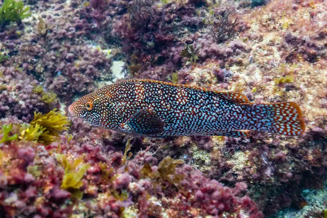 Ballan wrasseRegular local target1 placeWeymouth Stone PierOver breakwaterAround May–Oct
Photo: Diego Delso, via Wikimedia Commons, CC BY-SA 4.0; resized and trimmed to fit; shared under the same licence
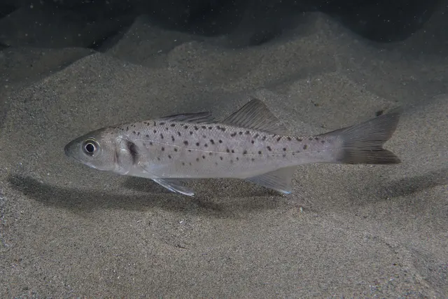 European sea bassRegular local target1 placeWeymouth Stone PierOver breakwaterAround May–Oct
Photo: Julien Renoult, via Wikimedia Commons, CC BY 4.0; resized and trimmed to fit
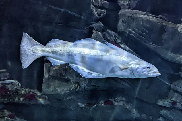 PollackRegular local target1 placeWeymouth Stone PierOver breakwaterAround May–Oct
Photo: Wilhelm Thomas Fiege, via Wikimedia Commons, CC BY-SA 4.0; resized and trimmed to fit; shared under the same licence
- European squidSeasonal1 placeWeymouth Stone PierOver breakwaterAround Jan–Feb, Oct–Dec
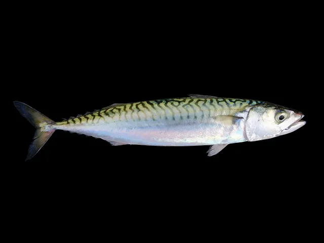 Atlantic mackerelRecorded here1 placeWeymouth Stone PierOver breakwater
Photo: Hans Hillewaert, via Wikimedia Commons, CC BY-SA 4.0; resized; shared under the same licence
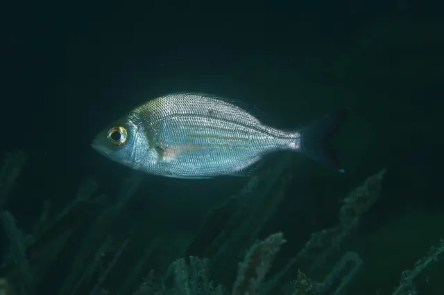 Black seabreamRecorded here1 placeWeymouth Stone PierOver breakwater
Photo: Julien Renoult, via iNaturalist, CC BY; resized and trimmed to fit
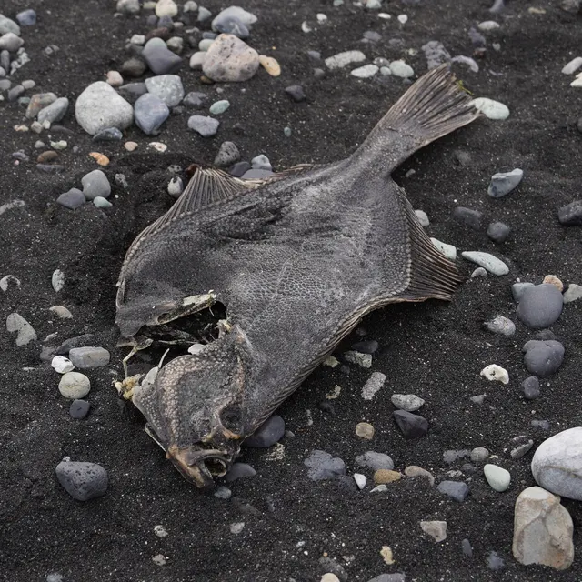 European flounderRecorded here1 placeWeymouth Stone PierOver breakwater
Photo: nbasargin, via iNaturalist, CC BY; resized and trimmed to fit
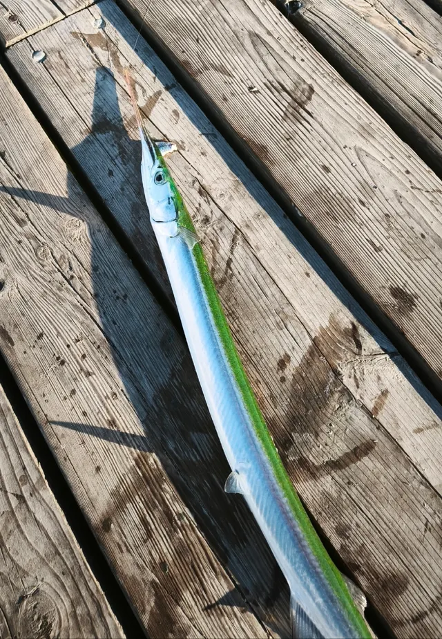 GarfishRecorded here1 placeWeymouth Stone PierOver breakwater
Photo: Dmitry Pietrow, via iNaturalist, CC BY; resized and trimmed to fit


Also documented from the shore: Small-spotted catshark
What these strengths mean
- Regular local target
- Fishing sources describe this as a normal local target here, not merely as caught.
- Seasonal
- Well supported, and concentrated in part of the year rather than spread through it.
- Recorded here
- At least one credible public account of this species being caught here. That is all it means.
- How breadth is counted
- A fish documented at six marks is shown as six marks: breadth never raises the strength on its own. A fishery account describes the fishing; a recorded catch reports one specific catch. How evidence is weighed.
Also associated with this ground
Recorded as present here without a documented method or strength behind them.
Fish documented nearby, not here
Nothing below has been documented at Weymouth Stone Pier itself. Each one has been documented at a named place on the same ground, and the places are listed with it. Treat this as what the water around here holds rather than as a catch list for this mark.
Also documented at neighbouring places
One or two accounts each, on the ground around here. Enough to know the fish is caught in these waters; not enough to say anything about this place.
From the shore
- Bull huss — documented at Ringstead Bay
- Conger eel — documented at Ringstead Bay
- Gilthead bream — documented at Preston Beach
- Thick-lipped grey mullet — documented at Weymouth Harbour
- Whiting — documented at Preston Beach; Ringstead Bay
- Common sole — documented at Preston Beach
- European plaice — documented at Preston Beach
- Starry smooth-hound — documented at Preston Beach
- Thornback ray — documented at Ringstead Bay
- Dab — documented at Preston Beach
How people fish it
Practised here: Sea fishing.
Methods the sources name for this ground. Each one is explained in full on its own page.
- Float fishing
Suspending a bait at a controlled depth beneath a buoyant indicator — the most visual, most controllable and most widely applicable method in angling.
- Spinning
Casting an artificial lure and retrieving it so that it moves like something alive — the most direct form of lure fishing.
- Ledgering
Fishing a bait on the bottom held by a weight, with no float — the simplest way to fish at distance, in depth, or in wind.
- Eging
Jigging for squid and cuttlefish with a barbed, weighted lure worked in lifts and pauses — a Japanese discipline with its own tackle, vocabulary and competitive scene.
Baits and lures for these fish
The baits and lures each of the fish above is commonly taken on, from that fish’s own page. This is what works for the fish, not a report of what people use on this particular water — local knowledge and the conditions on the day still decide.
Baits
- Ragworm — for Ballan wrasse, European sea bass, Pollack, Black seabream and 2 more
- Peeler crab — for Ballan wrasse, European sea bass, European flounder
- Sand eel — for European sea bass, Pollack, Garfish
- Crab and shellfish — for Ballan wrasse, European sea bass
- Fish strip and cut bait — for Garfish, Small-spotted catshark
- Squid and cuttlefish — for Black seabream, Small-spotted catshark
- Lugworm — for European flounder
- Prawns and shrimp — for Ballan wrasse
Also: Sea deadbaits
Lures
- Metal jigs — for European sea bass, Pollack, Atlantic mackerel
- Soft plastics — for Ballan wrasse, European sea bass, Pollack
- Spinners — for Atlantic mackerel, Garfish
- Jerkbaits — for European sea bass
- Jigs and jig heads — for Pollack
- Squid jigs — for European squid
- Streamers — for European sea bass
- Surface lures — for European sea bass
How to catch them: Ballan wrasse fishing · Bass fishing · Pollack fishing · Mackerel fishing · Flounder fishing · Garfish fishing · Dogfish (small-spotted catshark) fishing
Rods, reels and rigs for them: Ballan wrasse · European sea bass · Pollack · Atlantic mackerel · European flounder · Garfish
What guides and anglers say
These are statements other people have published about fishing here, summarised and attributed. Where one is a catch, it is that angler’s own report of one day; a recommendation is not a catch, and neither is a forecast.
The ground, as described
The regional guide describes cleaner ground on the harbour side of the pier and rougher ground to seaward, and says the pier is busy enough in summer that early morning or night is the time to fish it.
A published angling guide: British Sea Fishing.
The ground and the water
- The ground
- The stone arm on the southern side of the harbour entrance, with sheltered harbour water on the inside and distinctly rougher ground outside it. The two faces of the same structure fish as two marks.
- Exposure
- The outside face takes weather from the east and south; the inside face is harbour water and stays fishable when the outside does not.
- Depth
- Deeper and rougher outside than in, which is the whole reason the two faces hold different fish.
- Tide and flow
- The harbour stream runs past the head of it, and the Portland double tide applies.
Not to be confused with Weymouth Pleasure Pier or Weymouth Harbour, which are separate places on different ground.
Getting there
What public sources describe, last checked 2026-10-19. Car parks fill, services change and a path existing is not a path anybody may use — none of this is a guarantee of availability and none of it is permission to be anywhere.
- Getting to it
- The Stone Pier projects from the Nothe, on the southern side of Weymouth's harbour entrance; Visit Dorset gives its position as by the café on Barrack Road, DT4 8DZ. The Nothe Fort's visitor page describes a walk of about 20 minutes from Weymouth station along the seafront and harbour, and buses stopping at Boot Hill, about ten minutes' walk through Nothe Gardens. Dorset Council, which owns the harbour, said in July 2026 that the 500-metre pier stays open while its railings are repaired in sections, with temporary fencing where corrosion posed an immediate risk.
Parking
Nothe Gardens car parks, Barrack Road, Weymouth, DT4 8UF
Public car park · Charged
Three council pay-and-display car parks, charging 8am to 6pm, with nine disabled bays, as the Nothe Fort's page gives them.
Where this access information comes from
- Visit Dorset: Time and Tide, Weymouth sculpture trail — Visit Dorset (Credible secondary source)Relied on for: The pier projecting from the Nothe, by the café on Barrack Road.States this directlyPassage read and verified
- Nothe Fort: find us — Weymouth Civic Society (Nothe Fort) (Credible secondary source)Relied on for: The Nothe Gardens car parks, charges and hours, disabled bays, bus and walk.States this directlyPassage read and verified
- Dorset Council: Weymouth's Stone Pier undergoes upgrade ahead of peak summer season — Dorset Council, 2026 (Local authority, harbour or protected-area body)Relied on for: The pier's length, its ownership, and that it stays open during the works.States this directlyPassage read and verified
Through the year
Wrasse and pollack over the rough through the warmer months, mackerel, garfish and squid in the summer and autumn, flounder in the harbour water through the colder half.
The months the sources attach to each species here. Where a species carries no season it is listed underneath rather than assumed to run through the year.
| Species | J | F | M | A | M | J | J | A | S | O | N | D |
|---|---|---|---|---|---|---|---|---|---|---|---|---|
| Ballan wrasse — regular local target, recorded in May, June, July, August, September, October. | ||||||||||||
| European sea bass — regular local target, recorded in May, June, July, August, September, October. | ||||||||||||
| Pollack — regular local target, recorded in May, June, July, August, September, October. | ||||||||||||
| European squid — seasonal, recorded in October, November, December, January, February. |
Recorded here with no season stated: Atlantic mackerel, Black seabream, European flounder, Garfish, Small-spotted catshark.
Safety
Cold water shock — Can cause serious injury or death
General safety for this kind of ground, not a finding about this place.
UK coastal and inland water is cold enough for most of the year to trigger the involuntary gasp and the loss of swimming ability that decides most immersion deaths, and it does so within the first minute, long before hypothermia is relevant.
What reduces it: Wear a buoyancy aid rather than carry one, carry a means of calling for help on the person rather than in a bag, and plan on the assumption that an unplanned entry into the water is survivable only if somebody knows immediately.
Moving water and currents — Can cause serious injury or death
General safety for this kind of ground, not a finding about this place.
Tidal streams through narrow water run hard enough to overwhelm a small boat and to make a person in the water uncatchable. Overfalls stand up where the stream meets wind or shoaling ground, and the transition from workable to dangerous happens over minutes rather than hours as the tide turns.
What reduces it: Do not take a small boat into a race without knowing the times of slack water for that specific gate. Wear flotation. Fish from the shore where the ground allows it rather than from a boat that has to hold position in the stream.
Worse when:
- Wind against tide, which stands the water up into steep breaking overfalls
- Springs, when the stream runs at its hardest
- An engine failure, where a drift becomes a race transit with no way out of it
Boat traffic and being seen — Can cause injury needing treatment
An active harbour mouth with commercial, charter and leisure traffic passing close to the structures anglers stand on, and a line across a fairway is a hazard to both.
What reduces it: Watch the channel before casting, keep terminal tackle out of the fairway, and give way to traffic rather than expecting it to give way to a line.
Slips, trips and falls — Can cause injury needing treatment
A stone arm with an unguarded outer face, wet and weeded at the waterline, above deeper water than the inside suggests.
What reduces it: Stay back from the outer edge, treat wet stone as the hazard rather than the sea state, and do not fish the outside face alone in a swell.
Rules and access
Particular to this water: Under the harbour authority's General Directions 2024, rods may not be cast into the Inner Harbour entrance from 1 April to 30 September, no gear may be cast where it could obstruct vessels, and fish waste may not be thrown into the harbour. The directions do not say where angling is allowed on the walls or piers. This is an owned and operated structure. Whether angling is allowed on it, when, from where and on what terms is the operator's decision, is frequently seasonal, and changes without notice.
Beyond what is stated above, FishingHQ does not know the current access position here. Shore angling in England is not rod-licensed, but access rights, landowner permission, local authority and harbour byelaws, national and inshore fisheries measures, and site designations all apply and all change. Check the current position with the relevant inshore fisheries and conservation authority, the harbour or local authority, and the landowner before going.
Who holds the answer:
- The Inshore Fisheries and Conservation Authority for the district, which makes and enforces inshore byelaws.
- The Marine Management Organisation, for national recreational sea fishing measures in English waters.
- The local authority and, where one exists, the harbour authority, for access, byelaws and shellfish classification.
- The relevant Inshore Fisheries and Conservation Authority for the district, which makes and enforces inshore byelaws including those on bait collection.
- The harbour authority or commissioners, for fishing from piers, breakwaters and harbour structures, where permission is a local matter and changes.
- Natural England and the relevant protected site body, where a designation affects access or collection.
- The Maritime and Coastguard Agency and the RNLI, for safety guidance on this coast.
Nearby fishing
Other publicly documented places within about 40 km, by distance. Positions are approximate public geography and are never exact marks.
- Weymouth Pleasure Pier — under 2 km · Pier
- Weymouth Harbour — under 2 km · Harbour wall
- Ferrybridge and the Chesil Beach centre — under 2 km · Beach section
- Preston Beach — 2–5 km · Beach
- Chesil Cove — 2–5 km · Beach section
- Ringstead Bay — 5–10 km · Bay
- Portland Bill and Pulpit Rock — 10–25 km · Headland
- Abbotsbury beach — 10–25 km · Beach section
Sources for this place
- Sea Angler — Bauer Media (Specialist angling publication)Relied on for: Long-running published description of British sea angling practice by region, ground type and named mark.FishingHQ's interpretation of what it saysCitation checked — the work exists and is described correctly
- General angling website restatements of established technique — Various (Credible secondary source)Relied on for: Widely restated public descriptions of which places are conventionally fished and how, recorded as practitioner consensus rather than as scholarship, and not relied on for access, permission or any current rule.Background and mechanism onlyCitation checked — the work exists and is described correctly
- Dorset Council: Weymouth Harbour General Directions 2024 — Dorset Council, as harbour authority for Weymouth, 2024 (Local authority, harbour or protected-area body)Relied on for: The summer ban on casting into the Inner Harbour entrance, the obstruction rule and the waste rule.States this directlyPassage read and verified
- British Sea Fishing: south coast and south-west England shore marks — British Sea Fishing (Credible secondary source)Relied on for: The shore species the guide's own entry for this mark names, and the baits and methods it gives for them.States this directlyPassage read and verified
How FishingHQ labels evidence is explained in the evidence policy. Last reviewed 2026-08-16.
Something wrong or out of date?
If something on this page has changed, email us from your own account using the link that fits, with a link to where you saw the change if you can. Every report is checked by a person before anything is changed, and a report never appears on the site by itself. Please don’t send exact private marks.
Before you go
- Fish documented here
- 9 at this place itself. See them.
- Getting there
- Described from public sources, last checked 2026-10-19. Getting there.
- Rules particular to this water
- Under the harbour authority's General Directions 2024, rods may not be cast into the Inner Harbour entrance from 1 April to 30 September, no gear may be cast where it could obstruct vessels, and fish waste may not be thrown into the harbour. The directions do not say where angling is allowed on the walls or piers. From the body that sets it: Dorset Council, as harbour authority for Weymouth, read 2026-10-18; the rule is dated 2024. Applies to: Weymouth Harbour, under its harbour authority.
- This is an owned and operated structure. Whether angling is allowed on it, when, from where and on what terms is the operator's decision, is frequently seasonal, and changes without notice. General caution, not a rule of this water.
Nothing here is watched for change. Sources and who to ask.
- Hazards particular to this place
- 3 recorded. Safety.
Check before you travel
- Whether you may fish here, and whether a licence or permit is needed — start with the Inshore Fisheries and Conservation Authority for the district.
- The tide times and the forecast for the day you go.
- Anything recorded here was true when it was read; it is not watched for change.