Weymouth Pleasure Pier
Pier · Salt water · in Weymouth Bay
The seaward pier at the mouth of Weymouth harbour, a walkable structure standing in mixed ground with the harbour channel on one side and open bay on the other. Fish hold tight to the piles and the wall rather than out in front of it.
Safety: cold water shock — can cause serious injury or death. 2 more points apply here.
FishingHQ describes what this place is, not whether you may fish it. Access, permits and who to ask.
What you can catch here
Documented at this place, grouped by how you would be fishing, with how strongly the sources support each one. This is what has been written down, not a forecast, and being listed is never permission to fish.
From the shore · 6
 PollackRegular local target1 placeWeymouth Pleasure PierOver pierAround May–Oct
- European squidSeasonal1 place · 1 fishery account · 1 sourceWeymouth Pleasure PierOver pierSources name Eging with Squid jigsAround Jan–Feb, Oct–DecObserved October 2025
 Atlantic mackerelSeasonal1 placeWeymouth Pleasure PierOver pierAround Jun–Sept
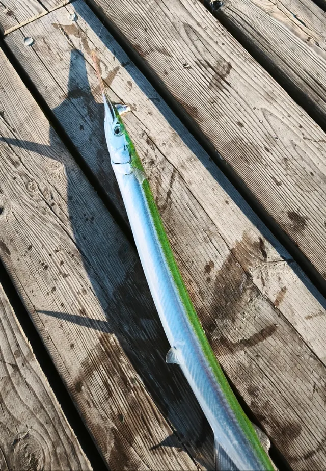 GarfishSeasonal1 placeWeymouth Pleasure PierOver pierAround Jun–Sept
 Ballan wrasseRecorded here1 placeWeymouth Pleasure PierOver pier
 European sea bassRecorded here1 placeWeymouth Pleasure PierOver pier
What these strengths mean
- Regular local target
- Fishing sources describe this as a normal local target here, not merely as caught.
- Seasonal
- Well supported, and concentrated in part of the year rather than spread through it.
- Recorded here
- At least one credible public account of this species being caught here. That is all it means.
- How breadth is counted
- A fish documented at six marks is shown as six marks: breadth never raises the strength on its own. A fishery account describes the fishing; a recorded catch reports one specific catch. How evidence is weighed.
Also associated with this ground
Recorded as present here without a documented method or strength behind them.
Fish documented nearby, not here
Nothing below has been documented at Weymouth Pleasure Pier itself. Each one has been documented at a named place on the same ground, and the places are listed with it. Treat this as what the water around here holds rather than as a catch list for this mark.
Widely documented on this ground
Documented at three or more neighbouring places, fished a way this place is also fished. That is a pattern about the ground rather than about any one mark, and it is the closest this site comes to saying you will probably meet a fish somewhere nothing has been written about.
From the shore
- European flounder — documented at Preston Beach; Weymouth Harbour; Weymouth Stone Pier
Also documented at neighbouring places
One or two accounts each, on the ground around here. Enough to know the fish is caught in these waters; not enough to say anything about this place.
From the shore
- Bull huss — documented at Ringstead Bay
- Conger eel — documented at Ringstead Bay
- Gilthead bream — documented at Preston Beach
- Thick-lipped grey mullet — documented at Weymouth Harbour
- Whiting — documented at Preston Beach; Ringstead Bay
- Common sole — documented at Preston Beach
- European plaice — documented at Preston Beach
- Starry smooth-hound — documented at Preston Beach
- Thornback ray — documented at Ringstead Bay
- Black seabream — documented at Weymouth Stone Pier
- Dab — documented at Preston Beach
How people fish it
Practised here: Sea fishing.
Methods the sources name for this ground. Each one is explained in full on its own page.
- Float fishing
Suspending a bait at a controlled depth beneath a buoyant indicator — the most visual, most controllable and most widely applicable method in angling.
- Spinning
Casting an artificial lure and retrieving it so that it moves like something alive — the most direct form of lure fishing.
- Ledgering
Fishing a bait on the bottom held by a weight, with no float — the simplest way to fish at distance, in depth, or in wind.
- Eging
Jigging for squid and cuttlefish with a barbed, weighted lure worked in lifts and pauses — a Japanese discipline with its own tackle, vocabulary and competitive scene.
The ground and the water
- The ground
- The seaward pier at the mouth of Weymouth harbour, a walkable structure standing in mixed ground with the harbour channel on one side and open bay on the other. Fish hold tight to the piles and the wall rather than out in front of it.
- Exposure
- Open to the bay and to easterly weather, and sheltered from the prevailing south-westerly by the Isle of Portland.
- Depth
- Enough water against the structure to fish close in. The source's own advice is that long casting is not needed here.
- Tide and flow
- The harbour empties and fills past the pier head, and the Portland double tide applies along this whole coast.
Not to be confused with Weymouth Stone Pier or Weymouth Harbour, which are separate records for different ground.
Through the year
Mackerel, garfish and squid from summer into autumn; wrasse and pollack over the warmer months; pouting and dogfish through the colder ones.
The months the sources attach to each species here. Where a species carries no season it is listed underneath rather than assumed to run through the year.
| Species | J | F | M | A | M | J | J | A | S | O | N | D |
|---|---|---|---|---|---|---|---|---|---|---|---|---|
| Pollack — regular local target, recorded in May, June, July, August, September, October. | ||||||||||||
| Atlantic mackerel — seasonal, recorded in June, July, August, September. | ||||||||||||
| European squid — seasonal, recorded in October, November, December, January, February. | ||||||||||||
| Garfish — seasonal, recorded in June, July, August, September. |
Recorded here with no season stated: Ballan wrasse, European sea bass.
Safety
Cold water shock — Can cause serious injury or death
UK coastal and inland water is cold enough for most of the year to trigger the involuntary gasp and the loss of swimming ability that decides most immersion deaths, and it does so within the first minute, long before hypothermia is relevant.
What reduces it: Wear a buoyancy aid rather than carry one, carry a means of calling for help on the person rather than in a bag, and plan on the assumption that an unplanned entry into the water is survivable only if somebody knows immediately.
Moving water and currents — Can cause serious injury or death
Tidal streams through narrow water run hard enough to overwhelm a small boat and to make a person in the water uncatchable. Overfalls stand up where the stream meets wind or shoaling ground, and the transition from workable to dangerous happens over minutes rather than hours as the tide turns.
What reduces it: Do not take a small boat into a race without knowing the times of slack water for that specific gate. Wear flotation. Fish from the shore where the ground allows it rather than from a boat that has to hold position in the stream.
Worse when:
- Wind against tide, which stands the water up into steep breaking overfalls
- Springs, when the stream runs at its hardest
- An engine failure, where a drift becomes a race transit with no way out of it
Boat traffic and being seen — Can cause injury needing treatment
An active harbour mouth with commercial, charter and leisure traffic passing close to the structures anglers stand on, and a line across a fairway is a hazard to both.
What reduces it: Watch the channel before casting, keep terminal tackle out of the fairway, and give way to traffic rather than expecting it to give way to a line.
Rules and access
FishingHQ does not know the current access position here. Shore angling in England is not rod-licensed, but access rights, landowner permission, local authority and harbour byelaws, national and inshore fisheries measures, and site designations all apply and all change. Check the current position with the relevant inshore fisheries and conservation authority, the harbour or local authority, and the landowner before going.
Particular to this water: This is an owned and operated structure. Whether angling is allowed on it, when, from where and on what terms is the operator's decision, is frequently seasonal, and changes without notice.
Who holds the answer:
- The Inshore Fisheries and Conservation Authority for the district, which makes and enforces inshore byelaws.
- The Marine Management Organisation, for national recreational sea fishing measures in English waters.
- The local authority and, where one exists, the harbour authority, for access, byelaws and shellfish classification.
- The relevant Inshore Fisheries and Conservation Authority for the district, which makes and enforces inshore byelaws including those on bait collection.
- The harbour authority or commissioners, for fishing from piers, breakwaters and harbour structures, where permission is a local matter and changes.
- Natural England and the relevant protected site body, where a designation affects access or collection.
- The Maritime and Coastguard Agency and the RNLI, for safety guidance on this coast.
Nearby fishing
Other publicly documented places within about 40 km, by distance. Positions are approximate public geography and are never exact marks.
- Weymouth Stone Pier — under 2 km · Breakwater
- Weymouth Harbour — under 2 km · Harbour wall
- Preston Beach — 2–5 km · Beach
- Ferrybridge and the Chesil Beach centre — 2–5 km · Beach section
- Chesil Cove — 5–10 km · Beach section
- Ringstead Bay — 5–10 km · Bay
- Portland Bill and Pulpit Rock — 10–25 km · Headland
- Abbotsbury beach — 10–25 km · Beach section
Sources for this place
- Sea Angler — Bauer Media (Specialist angling publication)Relied on for: Long-running published description of British sea angling practice by region, ground type and named mark.FishingHQ's interpretation of what it saysCitation checked — the work exists and is described correctly
- General angling website restatements of established technique — Various (Credible secondary source)Relied on for: Widely restated public descriptions of which places are conventionally fished and how, recorded as practitioner consensus rather than as scholarship, and not relied on for access, permission or any current rule.Background and mechanism onlyCitation checked — the work exists and is described correctly
How FishingHQ labels evidence is explained in the evidence policy. Last reviewed 2026-08-16.