The Bay of Biscay
Fishing regions · Last reviewed 2026-08-13
A wide shelf, a very abrupt canyon-cut edge, and a fetch open to the whole North Atlantic. Those three facts explain the tuna, the swell and the fisheries of two countries.
Safety: moving water and currents — can cause serious injury or death.
Being listed here is not permission to fish. What that meansClose
Access, fishing rights, seasons, licences, local bylaws and permitted methods vary and can change. Check current access, permission, local regulations, closures and restrictions before you travel or fish. FishingHQ describes what the ground is and names who holds the answer; it does not hold the answer itself.
Find the authority for a jurisdiction · What FishingHQ does and does not cover
The Bay of Biscay is a system-tier case because a small number of physical facts about the shape of the seabed and the exposure of the coast explain almost everything about fishing on both of its shores.
THE SHELF IS WIDE IN THE NORTH AND ALMOST ABSENT IN THE SOUTH. Off Brittany and the western approaches the continental shelf extends a long way offshore in relatively shallow water. Along the northern Spanish coast it narrows dramatically — in places deep water lies within a few kilometres of the beach. That single asymmetry means the same bay offers a broad, shallow, trawlable shelf fishery at one end and a deep-water fishery reachable from a small boat at the other.
THE SHELF EDGE IS CUT BY SUBMARINE CANYONS, and they are the productive feature. Canyons channel deep water upslope and generate mixing and localised upwelling, bringing nutrients into the lit surface layer where they drive production. That production supports the small pelagic fish — anchovy, sardine, mackerel, horse mackerel — which in turn support the large predators. The Cap Breton canyon, which runs close inshore off the south-eastern corner of the bay, is the best-known example of deep water arriving almost at the coast.
WHICH IS WHY THE TUNA ARE THERE. Albacore and bluefin move into the bay seasonally to feed on those small pelagic concentrations, and the historical Basque, Breton and Cantabrian tuna fisheries — pole and line, and live bait — exist because a large predator was reliably findable within reach of a working port. The recent re-establishment of recreational bluefin fisheries in these waters follows stock recovery rather than any local change.
AND THE FETCH EXPLAINS THE SWELL. The bay is open to the west and south-west across the whole North Atlantic, so Atlantic depressions tracking east deliver long-period ground swell into a bay that narrows and shallows toward its corner. Swell arriving from a storm days away and a thousand miles distant, into shoaling water, with no local wind to explain it, is the defining hazard of this coast and the reason its surf beaches are what they are. The same physics that produced a world-renowned surfing coast produces the conditions that kill shore anglers.
THE RIVERS MATTER TOO. The Loire, Gironde, Adour and the Cantabrian rivers deliver freshwater plumes, nutrients and migratory fish — and they are the systems through which salmon, sea trout, shad, lamprey and the critically endangered European eel move. The estuaries are nursery habitat for a substantial share of the bay's fish.
What fishing here is like
Two very different coasts around one body of water. The French side is long, low and sandy for hundreds of kilometres with a broad shelf offshore; the Spanish side is steep, rocky and indented with deep water close in. Both are exposed to Atlantic swell. The fishing ranges from surf beach angling for bass and sole on the Landes coast, through rock and harbour fishing on the Cantabrian shore, to offshore fisheries for tuna, and it includes an important estuarine and migratory-fish element in the great river mouths.
What you can target here
One entry per fish, grouped by how you would be fishing — because the answer is a different one from the rocks and from a boat. Each entry says how strongly the sources support it and how much evidence sits behind it. These are documented catches, not a forecast, and none of it is a statement that you may fish any particular ground.
From the shore · 6
 European sea bassCharacteristic of this water1 placeThe Bassin d'ArcachonOver bayAround May–Nov
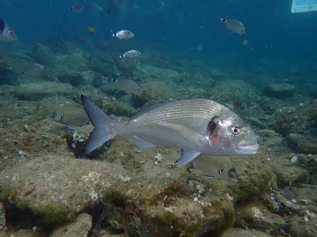 Gilthead breamCharacteristic of this water1 placeThe Bassin d'ArcachonOver bayAround May–Nov
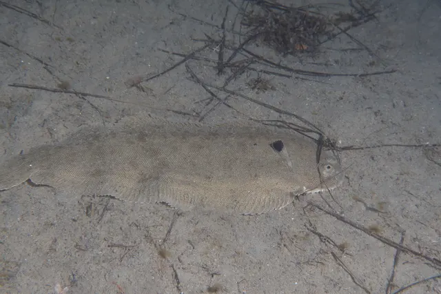 Common soleRegular local target1 placeThe Bassin d'ArcachonOver bay
- MeagreSeasonal1 placeThe Bassin d'ArcachonOver bayAround Jun–Sept
- Native oysterRecorded here1 placeThe Bassin d'ArcachonOver bay
 Thick-lipped grey mulletRecorded here1 placeThe Bassin d'ArcachonOver bay
From a boat · 3
What these strengths mean
- Characteristic of this water
- This water is strongly identified with this species by the sources that cover it.
- Regular local target
- Fishing sources describe this as a normal local target here, not merely as caught.
- Seasonal
- Well supported, and concentrated in part of the year rather than spread through it.
- Recorded here
- At least one credible public account of this species being caught here. That is all it means.
- How breadth is counted
- A fish documented at six marks is shown as six marks: breadth never raises the strength on its own. A fishery account describes the fishing; a recorded catch reports one specific catch. How evidence is weighed.
How people fish here
4 methods are recorded on the places documented here, counted from the records themselves rather than from what is practised in the country. Each opens a full guide to the technique.
Kayak fishing
Recorded at 1 place here, over bay.
A platform rather than a technique: quiet, shallow-draught access to water no other craft reaches, bought at the price of exposure, and a discipline where the decision not to launch is part of the skill.
Documented on the same ground: European sea bass, Gilthead bream, Common sole, Meagre, Native oyster, Thick-lipped grey mullet.
Ledgering
Recorded at 1 place here, over bay.
Fishing a bait on the bottom held by a weight, with no float — the simplest way to fish at distance, in depth, or in wind.
Documented on the same ground: European sea bass, Gilthead bream, Common sole, Meagre, Native oyster, Thick-lipped grey mullet.
Spinning
Recorded at 1 place here, over bay.
Casting an artificial lure and retrieving it so that it moves like something alive — the most direct form of lure fishing.
Documented on the same ground: European sea bass, Gilthead bream, Common sole, Meagre, Native oyster, Thick-lipped grey mullet.
Surfcasting
Recorded at 1 place here, over bay.
Casting heavy baited tackle from a beach into surf — a method defined by distance, by tide, and by reading water that all looks the same.
Documented on the same ground: European sea bass, Gilthead bream, Common sole, Meagre, Native oyster, Thick-lipped grey mullet.
These are the methods documented at the places FishingHQ holds here. A species listed beside a method is documented on the same ground, which is not the same as being taken that way — where a source establishes the method a fish was caught on, it is stated on that place’s own page. All fishing methods.
The fishing year here
The months the records under this area actually name, tightest season first. This is “observed in these months” rather than a season: a species whose months nobody recorded is not listed, because a gap in the evidence is not a year-round fishery.
- MeagreJune to September
- European sea bassMay to November
- Gilthead breamMay to November
What dominates
Surfcasting on the long sandy beaches of the French coast, principally for bass, sole, flatfish and rays. Rock and shore fishing on the Cantabrian and Basque coasts, where deep water close in changes the species available. Small-boat and charter fishing over the shelf and, in the south, over deep water reachable in a short run. Offshore trolling and lure fishing for tuna. A strong shellfish-gathering and shore-collecting tradition on both coasts. Spearfishing is well established on the rocky Spanish shore and is separately regulated.
The water available
Long dissipative sand beaches with bar-and-trough systems on the French coast; steep rocky shore, cliff and boulder ground on the Cantabrian coast; large estuaries and tidal river systems including the Loire, Gironde and Adour; a broad continental shelf in the north; submarine canyons cutting the shelf edge, with the Cap Breton canyon reaching close inshore; and open Atlantic water beyond.
How the rules are structured
Two national frameworks — French and Spanish — plus European Union instruments, plus substantial regional devolution on the Spanish side, where the Basque Country, Cantabria, Asturias and Galicia each administer their own recreational sea fishing arrangements. Recreational sea fishing licensing, permitted gear, size and bag limits, spearfishing rules and shellfish gathering are all handled at different levels in the two countries and differ between adjacent Spanish autonomous communities. Bluefin tuna is separately and tightly controlled under international arrangements. All of it changes, and FishingHQ does not state what any current rule is.
Who to ask
- The French maritime affairs administration and the relevant préfecture maritime, for recreational sea fishing on the French coast.
- The autonomous community government — Basque Country, Cantabria, Asturias, Galicia — for recreational sea fishing licensing on the Spanish coast.
- The Spanish national fisheries administration for matters reserved to it, including offshore waters and highly migratory species.
- ICCAT and the national authorities implementing it, for bluefin tuna and other highly migratory species.
- ICES, for stock assessment and scientific advice on the Biscay stocks.
- The relevant river basin authority for migratory species in the Loire, Gironde, Adour and Cantabrian river systems.
Words you will meet
- Baïne
- A temporary pool or lagoon that forms between the beach and a sandbar on the French Atlantic coast, draining seaward through a channel as the tide falls. The channel is a rip current, and baïnes are the specific and well-documented drowning hazard of the Landes and Gironde beaches.
- Cap Breton canyon
- A submarine canyon in the south-eastern corner of the bay that brings very deep water unusually close to shore, and the physical reason deep-water species are accessible from small ports there.
- Pêche à pied
- Gathering shellfish and other shore animals on foot at low tide. A long-established and culturally significant practice on the French coast, regulated by species, size, quantity, season and area, and subject to health classification of the ground.
- Bonito del norte
- The Cantabrian name for albacore, and the fish around which the summer pole-and-line tuna fishery of the Basque and Cantabrian ports has historically been built.
Conditions and hazards
Atlantic ground swell is the dominant hazard and the one visitors most consistently underestimate, because it is generated by weather that is nowhere near the coast. A calm, windless, sunny day can carry a large long-period swell that breaks heavily on shoaling ground, and nothing in the local conditions gives warning of it. On the sandy French coast, baïnes generate powerful and persistent rip currents in what looks like benign water, and they are a documented cause of drowning. On the rocky Spanish coast the hazard is being swept from a low rock platform by a set wave larger than those preceding it. Water temperature is cool enough that immersion is serious for most of the year, and the tidal range on the French coast is large, which cuts people off on beaches and sand bars that looked continuous. A swell forecast rather than a wind forecast is the operative document here.
Why a canyon makes a fishery
The most transferable piece of intelligence in this page is the relationship between submarine topography and productivity, because it explains fisheries all over the world and it is at its clearest here.
THE OPEN OCEAN'S SURFACE IS NUTRIENT-POOR. Sunlight penetrates only the upper layer, so photosynthesis can only happen there, and the nutrients that photosynthesis consumes sink out of it continuously as material dies and falls. Deep water is nutrient-rich and dark; surface water is lit and impoverished. Production is limited by whatever brings the two together.
A CANYON IS A MECHANISM FOR BRINGING THEM TOGETHER. Where a submarine canyon cuts into the shelf edge, currents flowing along the slope are deflected and forced upward, and internal waves break against the canyon walls. Both processes drive mixing and localised upwelling, delivering deep nutrients into the lit layer.
AND A FOOD CHAIN ASSEMBLES ON TOP OF IT. Phytoplankton bloom where the nutrients arrive; zooplankton graze them; small pelagic fish — anchovy, sardine, sprat, horse mackerel — concentrate on the zooplankton; and large predators concentrate on the small pelagics. The whole structure is anchored to a piece of seabed topography that never moves, which is why particular canyons and shelf edges have reputations that persist across generations.
THE BAY OF BISCAY IS A GOOD TEACHER because the effect is unusually accessible. The Cap Breton canyon brings that machinery close enough inshore that a small boat from a coastal port can reach water that would normally require a long offshore passage, and the tuna fisheries of the Basque and Cantabrian coasts were built on precisely that accident of geology.
THE GENERAL LESSON FOR A READER is that offshore fishing is not conducted at random over a featureless surface. It is conducted at physical discontinuities — canyons, shelf edges, seamounts, fronts where water masses meet — and those are the marine equivalent of structure on a reef. Understanding that turns a chart into a map of where production happens.
Backed by research — why, and the sources (2)
Supported by peer-reviewed research or fisheries science. The sources are listed and can be checked.
- Cefas science, advice and data on marine and freshwater environments — Centre for Environment, Fisheries and Aquaculture Science (Government fisheries body)Relied on for: Marine and freshwater environmental science, including the physical characterisation of shelf seas and the monitoring programmes that describe them.States this directlyCitation checked — the work exists and is described correctly
- ICES Advice on fishing opportunities, catch and effort — International Council for the Exploration of the Sea (Scientific institute)Relied on for: Ecoregion description, stock distribution and the hydrography of the area assessed.States this directlyCitation checked — the work exists and is described correctly
The swell that arrives from nowhere
The single most important safety fact about the Bay of Biscay is that its most dangerous condition is not generated locally and gives no local warning.
SWELL AND WIND WAVES ARE DIFFERENT THINGS. Wind waves are short, steep, disorganised and generated by the wind you can feel. Swell is what remains after waves leave the area that generated them: it sorts itself by wavelength as it travels, arriving as long, low, regular, organised undulations that may have crossed a thousand miles of ocean from a storm days earlier. It carries a great deal of energy and it looks like almost nothing in deep water.
WHAT SHOALING WATER DOES TO IT. As a long swell moves into shallowing water it slows, shortens and steepens, and the energy that was distributed through a deep column is concentrated into a shorter, taller wave that eventually breaks. A swell that was imperceptible offshore breaks heavily on a bar, a reef or a steep beach. The bay's geometry — open to the North Atlantic, narrowing and shallowing toward its south-eastern corner — funnels and concentrates that arriving energy.
SO THE DANGEROUS DAY LOOKS CALM. Sunny, windless, flat inshore, with a long swell running that produces a set of much larger breaking waves every few minutes. Anglers on rock platforms are swept off by a set wave after an hour of ordinary conditions; anglers wading on a sandy beach are knocked over by one; and a boat crossing a bar meets it at the worst moment.
WHICH IS WHY THE SWELL FORECAST IS THE DOCUMENT THAT MATTERS on this coast, and why reading only a wind forecast is reading the wrong half. Wave height, period and direction together are what describe the hazard: a two-metre swell at a long period carries far more energy than a two-metre wind sea at a short one, and it is the period that most people ignore.
AND THE BAÏNES ARE THE SANDY-COAST VERSION OF THE SAME ENERGY. Water pushed over a bar by breaking waves has to return seaward, and it does so through the gap in the bar as a concentrated, fast, seaward-flowing channel. That is a rip current, it is strongest at particular states of tide, and on this coast it is a documented and recurring cause of death.
Official guidance — why, and the sources (2)
Stated by a fisheries authority, scientific institute or recognised angling body. Authoritative, but summarising rather than demonstrating.
- United States Lifesaving Association public education on rip currents and the surf zone — United States Lifesaving Association (Water-safety or diver-training authority)Relied on for: Surf zone hazards, rip current formation and behaviour, and public guidance on shore-break and steep-beach hazards.States this directlyCitation checked — the work exists and is described correctly
- RNLI water safety guidance: cold water shock and Float to Live — Royal National Lifeboat Institution (Water-safety or diver-training authority)Relied on for: Shore angling hazards including shingle shore-break, cold water shock and tidal cut-off, and the advice to carry a means of calling for help.States this directlyPassage read and verified
A shelf, a canyon system and the swell that arrives from nowhere
The Bay of Biscay is a system record because its physical structure explains a fishery spanning two countries, and the structure has three components.
THE SHELF IS BROAD IN THE NORTH AND NARROW IN THE SOUTH. Off Brittany and the French coast the continental shelf extends a long way; along the northern Spanish coast it narrows sharply, so deep water comes close to shore. The same bay therefore offers a broad shallow shelf fishery at one end and a deep-water one at the other.
THE SHELF EDGE IS CUT BY CANYONS. Submarine canyons incise the shelf break, and they do two things: they channel deep water up towards the surface, and they concentrate life along their rims. The canyon systems here are among the most pronounced in the north-east Atlantic and they are a major reason the bay supports the pelagic fishery it does.
THE BAY IS A SWELL TRAP. Open to the west and north-west with a very long Atlantic fetch, and shoaling towards a concave coastline, Biscay concentrates swell generated by North Atlantic depressions. Its reputation among mariners is earned: a Biscay swell arrives with no local weather to explain it and breaks heavily on a coast that shoals.
UPWELLING OCCURS ALONG THE SOUTHERN AND WESTERN MARGINS, seasonally, adding nutrients to a system that is otherwise supplied by shelf mixing and river input.
MAJOR RIVERS DISCHARGE INTO IT, and their plumes stratify the surface layer and deliver nutrients and juveniles to the shelf.
AND THE WHOLE THING IS A NURSERY. The shelf waters of the bay are spawning and nursery ground for stocks fished across the north-east Atlantic, which is why what happens here matters well beyond it.
Backed by research — why, and the sources (2)
Supported by peer-reviewed research or fisheries science. The sources are listed and can be checked.
- ICES Advice on fishing opportunities, catch and effort — International Council for the Exploration of the Sea (Scientific institute)Relied on for: Stock assessment, the environmental drivers of stock distribution and abundance, and the scientific basis for advice in the sea areas concerned.States this directlyCitation checked — the work exists and is described correctly
- FishBase: a global information system on fishes — Froese, R. and D. Pauly, eds. — FishBase Consortium (Scientific institute)Relied on for: Distribution, temperature tolerance, migratory behaviour and habitat association of the species concerned.Background and mechanism onlyPassage read and verified
Tuna, anchovy and the stocks the whole north-east Atlantic depends on
Biscay's species picture is dominated by pelagics and by the fact that this is nursery ground for a much larger area.
ALBACORE IS THE BAY'S SIGNATURE FISHERY. Summer-feeding albacore tuna move into Biscay in numbers and support a pole-and-line and trolling fishery of long standing on both the French and Spanish sides — one of the more selective tuna fisheries in Europe.
BLUEFIN TUNA PASS THROUGH AND FEED HERE, and the bay was historically a major bluefin ground; the stock's collapse and subsequent recovery under international management is one of the better-known fisheries stories in the Atlantic.
ANCHOVY IS THE STOCK THAT DEFINES THE BAY'S MANAGEMENT HISTORY. The Bay of Biscay anchovy fishery was closed entirely for several years in the twenty-first century after the stock collapsed, and its recovery and reopening under a management plan is a reference case in European fisheries. It is the clearest local demonstration that a closure can work.
SARDINE, MACKEREL AND HORSE MACKEREL make up the rest of the small pelagic biomass, and mackerel in particular use the bay heavily.
HAKE IS THE PRINCIPAL DEMERSAL FISHERY, and the northern hake stock's decline and rebuilding is another well-documented case.
SEA BASS SPAWN IN THE BAY, and the winter spawning aggregations there were the subject of a controversial pelagic pair-trawl fishery whose restriction was central to the bass measures that now govern angling across northern Europe.
AND THE SHORE AND INSHORE FAUNA IS THE ATLANTIC EUROPEAN ONE — bass, seabream, pollack, wrasse, conger, rays and flatfish — with the southern part of the bay showing an increasingly warm-temperate component as water temperatures have risen.
Backed by research — why, and the sources (2)
Supported by peer-reviewed research or fisheries science. The sources are listed and can be checked.
- The Fishes of the British Isles and North-West Europe — Macmillan, 1969 (Reference work)Relied on for: Distribution, habitat association, depth and ground preference of fishes in north-west European and eastern Atlantic waters.States this directlyCitation checked — the work exists and is described correctly
- FishBase: a global information system on fishes — Froese, R. and D. Pauly, eds. — FishBase Consortium (Scientific institute)Relied on for: Distribution, habitat association and depth range recorded for the species.Background and mechanism onlyPassage read and verified
Pole-and-line tuna, surfcasting and a very large recreational fleet
The disciplines around the Bay of Biscay span an industrial pelagic fishery and one of Europe's largest recreational sectors.
POLE-AND-LINE AND TROLLING FOR ALBACORE is the bay's distinctive commercial discipline. Summer tuna taken one at a time on poles or on trolled lines from small and medium vessels is a selective method with a long tradition on both coasts, and it survives alongside more industrial gears.
PURSE SEINING FOR SMALL PELAGICS is the volume fishery, and its management — particularly for anchovy — is where the bay's fisheries politics concentrate.
TRAWLING FOR HAKE AND DEMERSAL SPECIES works the shelf and the canyon edges.
RECREATIONAL BOAT FISHING IS ENORMOUS ON THE FRENCH SIDE. France has one of the largest recreational sea fishing populations in Europe, and small-boat fishing along the Biscay coast for bass, pollack, seabream and, offshore, tuna is a mass activity.
SURFCASTING ON THE LANDES BEACHES is a discipline in its own right. The long straight sand coast of south-western France produces a powerful surf and a genuine surfcasting culture, with heavy tackle and long rods, targeting bass, meagre, rays and flatfish.
ROCK AND SHORE FISHING ON THE BASQUE AND CANTABRIAN COAST works a completely different ground — steep rock, deep water, heavy swell — for bass, seabream and pelagics.
SPEARFISHING IS STRONG ON BOTH SIDES and is separately licensed in both countries.
AND SHELLFISH GATHERING — pêche à pied on the French side, marisqueo on the Spanish — is a mass participation activity on the intertidal, subject to its own rules.
What experienced anglers do — why, and the sources (2)
Widely and independently recommended by experienced anglers and specialist sources. This is real angling knowledge, not proof: controlled evidence for it is limited, and FishingHQ records it as convention rather than as a demonstrated effect.
- General angling website restatements of established technique — Various (Credible secondary source)Relied on for: Widely restated practice associating this discipline or technique with this place, recorded as practitioner consensus rather than as tested fact.Background and mechanism onlyCitation checked — the work exists and is described correctly
- Fishers' Craft and Lettered Art: Tracts on Fishing from the End of the Middle Ages — University of Toronto Press, 1997 (Scientific literature)Relied on for: That fishing traditions develop around the water and fish available to them, and the historical method of reading such traditions from their documentary record.States this directlyCitation checked — the work exists and is described correctly
A summer tuna season and a winter of Atlantic swell
The bay's year is organised around the arrival of warm water and the departure of settled weather.
SUMMER IS THE PELAGIC SEASON. Albacore move into the bay as surface water warms, tuna fishing runs through the warmer months, and the small pelagic fishery is at its most active. This is when the bay's distinctive fisheries operate.
AUTUMN IS THE BEST INSHORE PERIOD. Water is still warm, bass and seabream feed hard, the first swells stir the ground, and shore and small-boat fishing is at its most productive.
WINTER IS SWELL SEASON AND IT IS SEVERE. North Atlantic depressions send very large ground swell into a bay that concentrates it, and the exposed coasts become unfishable and dangerous for extended periods. Biscay's reputation is a winter reputation.
BASS SPAWN IN WINTER IN OFFSHORE AGGREGATIONS in and around the bay, which is a biological fact with a substantial management history attached: the vulnerability of a spawning aggregation to a targeted fishery is precisely why the bass measures of the last decade exist.
SPRING IS THE UPWELLING AND RECRUITMENT PERIOD along the southern margins, with anchovy spawning and the shelf's productivity building.
RIVER FLOW IS A SEASONAL DRIVER on the French side, where the major rivers discharge, changing salinity and turbidity in the coastal zone and moving estuarine species.
AND THE MIGRATORY SALMONIDS RUN THE BAY'S RIVERS on their own calendar, at the southern edge of the Atlantic salmon's range, in systems whose runs are much reduced from historic levels.
Backed by research — why, and the sources (2)
Supported by peer-reviewed research or fisheries science. The sources are listed and can be checked.
- NASCO conservation and management of North Atlantic salmon — North Atlantic Salmon Conservation Organization (Government fisheries body)Relied on for: Anadromous salmonid biology, run timing, freshwater habitat requirements and the management principles applied to them.States this directlyCitation checked — the work exists and is described correctly
- FishBase: a global information system on fishes — Froese, R. and D. Pauly, eds. — FishBase Consortium (Scientific institute)Relied on for: Distribution, habitat association, migratory behaviour and life history of the species concerned.Background and mechanism onlyPassage read and verified
Two countries, one shelf and a management story worth knowing
The bay is shared, and its governance is a good illustration of how European fisheries management actually works.
TWO MEMBER STATES AND A COMMON POLICY. France and Spain each administer their own waters and fleets, within the European common fisheries policy, which sets quotas, technical measures and the framework for shared stocks. Regional advisory structures give the industry and other interests a formal route into that process.
STOCK ADVICE COMES FROM AN INTERNATIONAL SCIENTIFIC BODY, and quota decisions are political choices made against it, which is the structure a reader needs in order to follow any European fisheries argument.
THE ANCHOVY CLOSURE IS THE CASE TO KNOW. When the Bay of Biscay anchovy stock collapsed, the fishery was closed entirely for several years, and it was subsequently reopened under a management plan when the stock recovered. It is one of the clearest European demonstrations that a hard closure can rebuild a stock, and it was economically painful.
THE BASS MEASURES CAME OUT OF THIS BAY. Restrictions on targeting spawning aggregations, minimum sizes, bag limits for recreational anglers and gear restrictions were introduced across northern Europe following advice on a declining stock, and recreational anglers on this coast and far beyond feel them directly.
RECREATIONAL SEA FISHING IS LICENSED IN SPAIN AND NOT IN FRANCE, which is a striking difference across a single bay and a good illustration of why the framework question is national even where the fish are shared.
SHELLFISH GATHERING CARRIES SEPARATE PUBLIC HEALTH CONTROLS on both coasts, and local rules on pêche à pied and marisqueo differ substantially.
AND FISHINGHQ DOES NOT STATE WHAT ANY OF THIS CURRENTLY PERMITS. Quotas here are revised annually and bass measures have changed almost yearly.
Official guidance — why, and the sources (2)
Stated by a fisheries authority, scientific institute or recognised angling body. Authoritative, but summarising rather than demonstrating.
- Code of Conduct for Responsible Fisheries — Food and Agriculture Organization of the United Nations, Rome, 1995 (Standards body)Relied on for: Principles for the management of fisheries, including licensing, closed seasons, size limits and the treatment of small-scale and shared stocks.States this directlyCitation checked — the work exists and is described correctly
- Good Fish Guide — Marine Conservation Society (Conservation authority)Relied on for: Assessment of fisheries and the management measures applied to them, including the instruments used and their purpose.Background and mechanism onlyCitation checked — the work exists and is described correctly
Shelf, canyon, plume: reading a sea area
The vocabulary of this bay is oceanographic and fisheries-scientific, because it is a sea area whose management is scientific.
SHELF AND SHELF BREAK NAME THE FUNDAMENTAL STRUCTURE. The continental shelf is the shallow submerged margin of the continent; the shelf break is where it drops away. Most of the bay's demersal fishing happens on the shelf and most of its pelagic fishing along and beyond the break.
SUBMARINE CANYON NAMES THE INCISIONS CUTTING THE SHELF BREAK. They channel deep water upward and concentrate life along their rims, and they are why particular positions along an otherwise featureless shelf edge fish consistently.
RIVER PLUME NAMES THE BODY OF FRESH OR BRACKISH WATER spreading over the sea surface from a river mouth. Plumes stratify the water column, carry nutrients and juveniles, and their edges are fishing features.
STOCK IS A MANAGEMENT UNIT RATHER THAN A BIOLOGICAL ONE, and understanding that distinction is essential to reading anything about this bay. A stock is the population unit assessed and managed; it may or may not correspond exactly to a biological population.
TOTAL ALLOWABLE CATCH NAMES THE QUOTA SET FOR A STOCK for a period, allocated between countries. It is the instrument every European fisheries argument is ultimately about.
SPAWNING AGGREGATION NAMES THE GATHERING OF ADULTS to reproduce, and here it names the specific bass behaviour whose exploitation drove a decade of management change.
AND PÊCHE À PIED — FISHING ON FOOT — NAMES THE FRENCH INTERTIDAL GATHERING TRADITION, a mass participation activity with no British equivalent in scale, and it is the term a visitor to the French side will meet first.
What experienced anglers do — why, and the sources (2)
Widely and independently recommended by experienced anglers and specialist sources. This is real angling knowledge, not proof: controlled evidence for it is limited, and FishingHQ records it as convention rather than as a demonstrated effect.
- General angling website restatements of established technique — Various (Credible secondary source)Relied on for: Widely restated practice associating this discipline or technique with this place, recorded as practitioner consensus rather than as tested fact.Background and mechanism onlyCitation checked — the work exists and is described correctly
- Fishers' Craft and Lettered Art: Tracts on Fishing from the End of the Middle Ages — University of Toronto Press, 1997 (Scientific literature)Relied on for: That fishing traditions develop around the water and fish available to them, and the historical method of reading such traditions from their documentary record.States this directlyCitation checked — the work exists and is described correctly
Basque whalers, cod fleets and a modern collapse and recovery
Biscay has one of the longest and best-documented fishing histories in the Atlantic, and it starts earlier than most.
THE BASQUE WHALE FISHERY IS THE OLDEST CHAPTER. Basque communities on both sides of the bay were hunting right whales from shore and then from vessels from the medieval period, and Basque whalers subsequently crossed the Atlantic to Newfoundland and Labrador. It is among the earliest documented commercial marine hunting industries in Europe.
THE COD FLEETS FOLLOWED. Basque and French vessels fished the Grand Banks for centuries, salting cod for the European market, and the bacalao and morue trades shaped the food cultures on both sides of the bay.
THE ANCHOVY AND SARDINE CANNING INDUSTRY built the modern coastal economy on both coasts, supported by the shelf's productivity.
THE ALBACORE POLE-AND-LINE FISHERY IS A CONTINUING TRADITION, and its survival alongside more efficient gears is a deliberate choice with a selectivity argument behind it.
THE ANCHOVY COLLAPSE AND CLOSURE IS THE MODERN EVENT. The stock's decline, the total closure of the fishery for several years, and its recovery and reopening under a management plan is the reference case in recent European fisheries history, and it is the reason the bay is cited in arguments about closures everywhere.
THE BASS STORY IS THE OTHER MODERN CHAPTER, in which a targeted fishery on winter spawning aggregations contributed to a decline that produced Europe-wide restrictions affecting recreational anglers a thousand kilometres away.
AND THE ERIKA AND PRESTIGE OIL SPILLS affected the bay's coasts within recent decades, with substantial consequences for inshore fisheries and for public attitudes to shipping in these waters.
Official guidance — why, and the sources (2)
Stated by a fisheries authority, scientific institute or recognised angling body. Authoritative, but summarising rather than demonstrating.
- Fishers' Craft and Lettered Art: Tracts on Fishing from the End of the Middle Ages — University of Toronto Press, 1997 (Scientific literature)Relied on for: The historical development of European fishing practice, its transmission and its documentary record, including medieval and early modern fisheries.States this directlyCitation checked — the work exists and is described correctly
- Code of Conduct for Responsible Fisheries — Food and Agriculture Organization of the United Nations, Rome, 1995 (Standards body)Relied on for: Principles for fisheries management including the treatment of traditional, small-scale and shared fisheries, against which historical arrangements can be read.Background and mechanism onlyCitation checked — the work exists and is described correctly
Two fishing cultures facing each other across one sea
Biscay is shared by two countries whose fishing cultures are genuinely different, and the contrast is instructive.
THE FRENCH SIDE IS A MASS RECREATIONAL CULTURE. France has one of Europe's largest populations of recreational sea anglers and an enormous small-boat sector, and the activity is treated as an ordinary leisure pursuit rather than a specialist one. Pêche à pied — gathering shellfish on foot at low water — is a family activity practised at very large scale on the Atlantic coast.
THE SPANISH SIDE IS A PROFESSIONAL AND LICENSED CULTURE. Recreational fishing is licensed by category, the professional inshore sector is organised through guilds, and the relationship between the two is more formally delineated.
THE BASQUE MARITIME IDENTITY SPANS BOTH SIDES and is distinct from either national one, with its own language, its own boat traditions, its own tuna fishery and a food culture built on cod, anchovy and tuna.
SURFING AND SURFCASTING SHARE THE LANDES COAST, and the long straight beaches of south-western France support both cultures in the same water with the usual mild friction.
THE TUNA FISHERY CARRIES REAL PRIDE on both sides, and the pole-and-line boats and their crews occupy a position in local esteem comparable to any craft fishery.
THE FOOD CULTURE IS PELAGIC. Anchovy, sardine, tuna and hake are central to the cuisines of both coasts in a way that reflects exactly what the shelf produces.
AND THE SEA'S REPUTATION IS SHARED. Biscay's name means rough weather to mariners across Europe, and the coastal cultures on both sides carry a respect for Atlantic swell that a visitor should adopt rather than test.
What experienced anglers do — why, and the sources (2)
Widely and independently recommended by experienced anglers and specialist sources. This is real angling knowledge, not proof: controlled evidence for it is limited, and FishingHQ records it as convention rather than as a demonstrated effect.
- General angling website restatements of established technique — Various (Credible secondary source)Relied on for: Widely restated practice associating this discipline or technique with this place, recorded as practitioner consensus rather than as tested fact.Background and mechanism onlyCitation checked — the work exists and is described correctly
- Fishers' Craft and Lettered Art: Tracts on Fishing from the End of the Middle Ages — University of Toronto Press, 1997 (Scientific literature)Relied on for: That fishing traditions develop around the water and fish available to them, and the historical method of reading such traditions from their documentary record.States this directlyCitation checked — the work exists and is described correctly
Some of what lives here
Fish recorded here that FishingHQ holds a reviewed photograph of. It is not a complete list of what The Bay of Biscay holds, and it is not a prediction that you will catch any of them — it is a way in to the ones we can show you.
- European sea bassA fast, predatory inshore fish that hunts in broken water and surf, and one of the most closely managed recreational species in European seas.
Julien Renoult — CC BY 4.0, via Wikimedia Commons
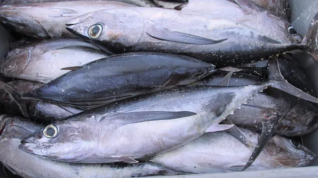 AlbacoreThe long-finned tuna of temperate open ocean — smaller and cooler-water than its relatives, with pectoral fins so long they are the identification.
Joachim Langeneck — CC BY-SA 4.0, via Wikimedia Commons
- Common soleA nocturnal, sand-dwelling flatfish with a rounded head and a small twisted mouth, and one of the most valuable food fish in European waters.
Julien Renoult — CC BY, via iNaturalist
- Gilthead breamThe Mediterranean's most prized sea bream, marked by a golden band between the eyes, with a jaw powerful enough to crush shellfish and a range now expanding northward.
jujurenoult — CC BY 4.0, via Wikimedia Commons
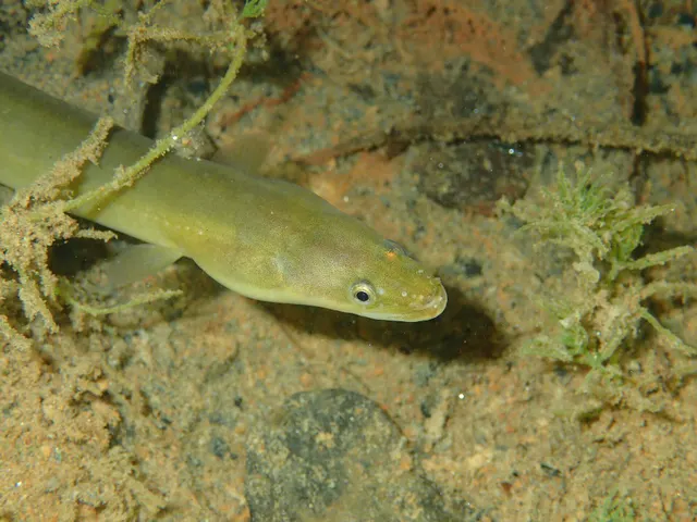 European eelA Critically Endangered fish that breeds in the Sargasso Sea, drifts to Europe as a transparent larva, lives decades in fresh water and returns once to spawn and die.
jujurenoult — CC BY 4.0, via Wikimedia Commons
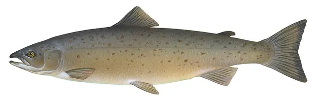 Atlantic salmonAn anadromous salmonid that migrates from its natal river to the North Atlantic and returns to spawn — and a species in serious, well-documented decline.
Knepp, Timothy, Public domain, via Wikimedia Commons
Places within this area
Publicly documented fishing geography. FishingHQ describes what the ground is; it does not say whether you may fish it, and every one of these sends that question to the body that holds the answer. Browse every place in this part of the world.
Who to ask before fishing any of these
FishingHQ does not know the current access position here. Recreational sea fishing in France is not generally licensed for shore angling, but national and European measures on species, sizes, quantities and gear apply, some species carry a declaration or marking requirement, and access to structures, beaches and shellfish grounds is governed locally. All of it changes. Check the current position with the maritime prefecture or the departmental directorate for the sea, and with the commune, before going. This water is tidal and transitional, so the freshwater regime may also apply above the tidal limit: FishingHQ does not know the current access position here. Inland fishing in France runs through membership: an angler joins an approved local fishing association, which is affiliated to a departmental federation, and pays the national levy alongside it — so the permission and the licence arrive together and are bought from the association rather than from a state counter. Waters, seasons, methods and reciprocity arrangements differ by department and change. Check with the departmental fishing federation and the local association before going.
The Bassin d'Arcachon
Bay · Brackish water
A large triangular tidal lagoon behind a sand spit on the Aquitaine coast, entered through a shifting channel between banks, with extensive drying sand and mud flats, oyster beds throughout, eelgrass meadows and deep scoured channels.
Sheltered inside, and the entrance between the banks is one of the more dangerous bar crossings on the French coast when swell meets the ebb.
Particular to this ground: tides and being cut off.
Severe hazards of The Bay of Biscay apply here: moving water and currents.
Particular to this water: Shellfish harvesting areas are classified for food safety and are opened and closed on monitoring results a gatherer cannot see. Neither cooking nor appearance removes a biotoxin. Check the current classification with the responsible authority before taking anything.
Safety
Moving water and currents — Can cause serious injury or death
Long-period Atlantic ground swell arrives independently of local wind, steepens over shoaling ground and breaks heavily in sets. People are swept from rock platforms and knocked over while wading on days that appear calm, and baïne rip currents on the sandy coast carry swimmers and waders seaward through gaps in offshore bars.
What reduces it: Read a swell forecast — height, period and direction — rather than only a wind forecast, and treat a long period as the warning it is. Watch a full set before committing to a rock platform or a wading position, never fish a low platform alone, and treat a windless sunny day with a running swell as a hazardous day rather than a safe one.
Worse when:
- Long-period swell from a distant Atlantic depression, which produces the largest sets with the least local warning.
- Shoaling ground — bars, reefs, steep beaches and the shallow south-eastern corner of the bay.
- Large spring tidal ranges on the French coast, which change the position of the break and cut off ground behind waders.
Further safety reading
- Rock platform and cliff safety — Long-period Atlantic ground swell arrives independently of local wind and breaks heavily on the Cantabrian rock platforms in sets, which is the characteristic accident on this coast.
- Tides and being cut off — Tidal range on the French coast is large, and beaches and sand bars that appeared continuous are separated by the flood.
- Wading safely — The baïnes of the French sandy coast generate powerful rip currents through gaps in offshore bars in water that looks benign, and they are a documented and recurring cause of drowning.
Check the rules before you fish
Fishing laws, bylaws, access rules, seasons, bait restrictions and permitted methods vary by location and can change. Check the current rules from the relevant authority and the water you intend to fish before fishing.
Check with:
- Current national or regional law for where you are fishing
- Current local bylaws
- The relevant fisheries authority
- The landowner, club or fishery whose water it is
- Any restrictions specific to the species or the method you intend to use
Where to go next
What swims here
- AlbacoreThe summer tuna of the Cantabrian and Basque ports, taken historically by pole and line and live bait over the shelf edge — the bonito del norte fishery.
- Atlantic bluefin tunaMoves into the bay seasonally to feed on concentrations of small pelagic fish generated at the shelf edge and over the canyons, which is the physical basis of the historical Basque and Cantabrian tuna fisheries.
- Atlantic salmonReturns to the rivers of the bay's rim, at the southern edge of the species' European range, where populations are small and locally distinct.
- Common soleUses the extensive clean sandy ground of the French coast, and supports both a commercial fishery and a shore night fishery over it.
- European anchovyA defining small pelagic of the bay, whose concentrations at the shelf edge and over the canyons are what the tuna come for and what the region's pelagic fisheries are built on.
- European eelGlass eels arrive on this coast and ascend the Loire, Gironde, Adour and the Cantabrian rivers, which historically supported one of the most significant elver fisheries in Europe and is now among the most tightly restricted.
- European sea bassPresent along both coasts, using the surf beaches of the French side and the rocky ground of the Cantabrian shore, and the principal recreational target of the bay's shore fisheries.
- Gilthead breamPresent along both coasts with juveniles using the estuaries and coastal lagoons of the bay before returning to more saline water as adults.
1 more
- Sea lamprey Fish
How this compares
- FranceThe bay's northern and eastern shores are French, and the swell, shelf and canyon structure the system page describes is what the French Atlantic coast is exposed to.
- PortugalPortugal lies south of the bay proper and shares the Iberian upwelling that drives its productivity, which is why the two coasts fish alike and are administered entirely differently.
Environment and conservation
Sources and evidence
- ICES Advice on fishing opportunities, catch and effort — International Council for the Exploration of the Sea (Scientific institute)Relied on for: Stock distribution, ecoregion boundaries and the physical description of the sea areas assessed, including salinity, depth and hydrography.States this directlyCitation checked — the work exists and is described correctly
- FishBase: a global information system on fishes — Froese, R. and D. Pauly, eds. — FishBase Consortium (Scientific institute)Relied on for: Distribution, salinity tolerance and habitat association of the species named as characteristic of these waters.States this directlyPassage read and verified
- Cefas science, advice and data on marine and freshwater environments — Centre for Environment, Fisheries and Aquaculture Science (Government fisheries body)Relied on for: Marine and freshwater environmental science, including the physical characterisation of shelf seas and the monitoring programmes that describe them.States this directlyCitation checked — the work exists and is described correctly
- ICES Advice on fishing opportunities, catch and effort — International Council for the Exploration of the Sea (Scientific institute)Relied on for: Ecoregion description, stock distribution and the hydrography of the area assessed.States this directlyCitation checked — the work exists and is described correctly
Why the 17 connections on this page are here, and the sources
What swims here
Backed by research — 9 connections
Supported by peer-reviewed research or fisheries science. The sources are listed and can be checked.
Albacore
Occurrence of the species in this system or along this coast: a statement about the animal's distribution, not a venue recommendation.
- FishBase: a global information system on fishes — Froese, R. and D. Pauly, eds. — FishBase Consortium (Scientific institute)Relied on for: Distribution, salinity tolerance and habitat association recorded for the species, including its occurrence in this system.States this directlyPassage read and verified
- The IUCN Red List of Threatened Species — International Union for Conservation of Nature (Conservation authority)Relied on for: Assessment and range description for the species, including the waters in which it occurs.Background and mechanism onlyCitation checked — the work exists and is described correctly
Atlantic bluefin tuna
Occurrence of the species in this system or along this coast: a statement about the animal's distribution, not a venue recommendation.
- FishBase: a global information system on fishes — Froese, R. and D. Pauly, eds. — FishBase Consortium (Scientific institute)Relied on for: Distribution, salinity tolerance and habitat association recorded for the species, including its occurrence in this system.States this directlyPassage read and verified
- The IUCN Red List of Threatened Species — International Union for Conservation of Nature (Conservation authority)Relied on for: Assessment and range description for the species, including the waters in which it occurs.Background and mechanism onlyCitation checked — the work exists and is described correctly
Atlantic salmon
Occurrence of the species in this system or along this coast: a statement about the animal's distribution, not a venue recommendation.
- Freshwater Fishes of the British Isles — HarperCollins (New Naturalist 75), 1992 (Reference work)Relied on for: Distribution and habitat association of European freshwater fishes, including their occurrence in brackish and coastal waters.States this directlyCitation checked — the work exists and is described correctly
- FishBase: a global information system on fishes — Froese, R. and D. Pauly, eds. — FishBase Consortium (Scientific institute)Relied on for: Salinity tolerance and distribution recorded for the species.States this directlyPassage read and verified
Common sole
Occurrence of the species in this system or along this coast: a statement about the animal's distribution, not a venue recommendation.
- The Fishes of the British Isles and North-West Europe — Macmillan, 1969 (Reference work)Relied on for: Distribution and habitat association of fishes in British and north-west European waters.States this directlyCitation checked — the work exists and is described correctly
- FishBase: a global information system on fishes — Froese, R. and D. Pauly, eds. — FishBase Consortium (Scientific institute)Relied on for: Distribution, depth range and habitat association recorded for the species.States this directlyPassage read and verified
European anchovy
Occurrence of the species in this system or along this coast: a statement about the animal's distribution, not a venue recommendation.
- The Fishes of the British Isles and North-West Europe — Macmillan, 1969 (Reference work)Relied on for: Distribution and habitat association of fishes in British and north-west European waters.States this directlyCitation checked — the work exists and is described correctly
- FishBase: a global information system on fishes — Froese, R. and D. Pauly, eds. — FishBase Consortium (Scientific institute)Relied on for: Distribution, depth range and habitat association recorded for the species.States this directlyPassage read and verified
European eel
Occurrence of the species in this system or along this coast: a statement about the animal's distribution, not a venue recommendation.
- Freshwater Fishes of the British Isles — HarperCollins (New Naturalist 75), 1992 (Reference work)Relied on for: Distribution and habitat association of European freshwater fishes, including their occurrence in brackish and coastal waters.States this directlyCitation checked — the work exists and is described correctly
- FishBase: a global information system on fishes — Froese, R. and D. Pauly, eds. — FishBase Consortium (Scientific institute)Relied on for: Salinity tolerance and distribution recorded for the species.States this directlyPassage read and verified
European sea bass
Occurrence of the species in this system or along this coast: a statement about the animal's distribution, not a venue recommendation.
- The Fishes of the British Isles and North-West Europe — Macmillan, 1969 (Reference work)Relied on for: Distribution and habitat association of fishes in British and north-west European waters.States this directlyCitation checked — the work exists and is described correctly
- FishBase: a global information system on fishes — Froese, R. and D. Pauly, eds. — FishBase Consortium (Scientific institute)Relied on for: Distribution, depth range and habitat association recorded for the species.States this directlyPassage read and verified
Gilthead bream
Occurrence of the species in this system or along this coast: a statement about the animal's distribution, not a venue recommendation.
- The Fishes of the British Isles and North-West Europe — Macmillan, 1969 (Reference work)Relied on for: Distribution and habitat association of fishes in British and north-west European waters.States this directlyCitation checked — the work exists and is described correctly
- FishBase: a global information system on fishes — Froese, R. and D. Pauly, eds. — FishBase Consortium (Scientific institute)Relied on for: Distribution, depth range and habitat association recorded for the species.States this directlyPassage read and verified
Sea lamprey
That the species occurs in these waters, drawn from distribution science. It is not a statement that anybody will encounter one.
- FishBase: a global information system on fishes — Froese, R. and D. Pauly, eds. — FishBase Consortium (Scientific institute)Relied on for: Distribution, environment and diadromous parasitic life history of Petromyzon marinus.States this directlyPassage read and verified
- Freshwater Fishes of the British Isles — HarperCollins (New Naturalist 75), 1992 (Reference work)Relied on for: The lampreys of the British Isles and north-west Europe: identification, the ammocoete larval phase, spawning behaviour and population status.States this directlyCitation checked — the work exists and is described correctly
How people fish here
What experienced anglers do — 2 connections
Widely and independently recommended by experienced anglers and specialist sources. This is real angling knowledge, not proof: controlled evidence for it is limited, and FishingHQ records it as convention rather than as a demonstrated effect.
Sea fishing
The discipline that dominates fishing in this place, recorded as established practice rather than as a ranking.
- General angling website restatements of established technique — Various (Credible secondary source)Relied on for: Widely restated practice associating this discipline with this coast or system, recorded as practitioner consensus rather than as tested fact.Background and mechanism onlyCitation checked — the work exists and is described correctly
- Fishers' Craft and Lettered Art: Tracts on Fishing from the End of the Middle Ages — University of Toronto Press, 1997 (Scientific literature)Relied on for: That fishing traditions develop around the water and fish available to them, and the historical method of reading such traditions.States this directlyCitation checked — the work exists and is described correctly
Spearfishing
The discipline that dominates fishing in this place, recorded as established practice rather than as a ranking.
- General angling website restatements of established technique — Various (Credible secondary source)Relied on for: Widely restated practice associating this discipline with this coast or system, recorded as practitioner consensus rather than as tested fact.Background and mechanism onlyCitation checked — the work exists and is described correctly
- Fishers' Craft and Lettered Art: Tracts on Fishing from the End of the Middle Ages — University of Toronto Press, 1997 (Scientific literature)Relied on for: That fishing traditions develop around the water and fish available to them, and the historical method of reading such traditions.States this directlyCitation checked — the work exists and is described correctly
How this compares
What experienced anglers do — 2 connections
Widely and independently recommended by experienced anglers and specialist sources. This is real angling knowledge, not proof: controlled evidence for it is limited, and FishingHQ records it as convention rather than as a demonstrated effect.
France
One of these areas contains the other, so the conditions described in the larger are the conditions the smaller inherits — which makes the comparison a matter of geography rather than of opinion.
- General angling website restatements of established technique — Various (Credible secondary source)Relied on for: Widely restated practice associating this discipline with this place, recorded as practitioner consensus rather than as tested fact.Background and mechanism onlyCitation checked — the work exists and is described correctly
- Fishers' Craft and Lettered Art: Tracts on Fishing from the End of the Middle Ages — University of Toronto Press, 1997 (Scientific literature)Relied on for: That fishing traditions develop around the water and fish available to them, and the historical method of reading such traditions.States this directlyCitation checked — the work exists and is described correctly
Portugal
One of these areas contains the other, so the conditions described in the larger are the conditions the smaller inherits — which makes the comparison a matter of geography rather than of opinion.
- General angling website restatements of established technique — Various (Credible secondary source)Relied on for: Widely restated practice associating this discipline with this place, recorded as practitioner consensus rather than as tested fact.Background and mechanism onlyCitation checked — the work exists and is described correctly
- Fishers' Craft and Lettered Art: Tracts on Fishing from the End of the Middle Ages — University of Toronto Press, 1997 (Scientific literature)Relied on for: That fishing traditions develop around the water and fish available to them, and the historical method of reading such traditions.States this directlyCitation checked — the work exists and is described correctly
Safety reading
Official guidance — 3 connections
Stated by a fisheries authority, scientific institute or recognised angling body. Authoritative, but summarising rather than demonstrating.
Rock platform and cliff safety
A hazard characteristic of this place, connected to the safety topic that explains the mechanism.
- United States Lifesaving Association public education on rip currents and the surf zone — United States Lifesaving Association (Water-safety or diver-training authority)Relied on for: Surf zone hazards, rip current formation, shore-break and steep-beach hazards, and public guidance on them.States this directlyCitation checked — the work exists and is described correctly
- RNLI water safety guidance: cold water shock and Float to Live — Royal National Lifeboat Institution (Water-safety or diver-training authority)Relied on for: Shore angling hazards including shore-break, cold water shock and being swept in.States this directlyPassage read and verified
Tides and being cut off
A hazard characteristic of this place, connected to the safety topic that explains the mechanism.
- RNLI water safety guidance: cold water shock and Float to Live — Royal National Lifeboat Institution (Water-safety or diver-training authority)Relied on for: Cold water shock and the immersion response, tidal cut-off, shore angling hazards and small-craft guidance.States this directlyPassage read and verified
- RoSPA water safety information and UK accidental drowning statistics — Royal Society for the Prevention of Accidents (Water-safety or diver-training authority)Relied on for: Accidental drowning statistics and the circumstances in which recreational water users are most often killed.States this directlyPassage read and verified
Wading safely
A hazard characteristic of this place, connected to the safety topic that explains the mechanism.
- United States Lifesaving Association public education on rip currents and the surf zone — United States Lifesaving Association (Water-safety or diver-training authority)Relied on for: Surf zone hazards, rip current formation, shore-break and steep-beach hazards, and public guidance on them.States this directlyCitation checked — the work exists and is described correctly
- RNLI water safety guidance: cold water shock and Float to Live — Royal National Lifeboat Institution (Water-safety or diver-training authority)Relied on for: Shore angling hazards including shore-break, cold water shock and being swept in.States this directlyPassage read and verified
Environment and conservation
Official guidance — 1 connection
Stated by a fisheries authority, scientific institute or recognised angling body. Authoritative, but summarising rather than demonstrating.
Fish stocks and sustainability
An environmental pressure operating in this system, recorded rather than adjudicated.
- ICES Advice on fishing opportunities, catch and effort — International Council for the Exploration of the Sea (Scientific institute)Relied on for: Stock status, environmental pressures and the scientific basis for advice in the sea area concerned.States this directlyCitation checked — the work exists and is described correctly
- Good Fish Guide — Marine Conservation Society (Conservation authority)Relied on for: Stock and method assessment and the conservation measures applied to the fisheries.Background and mechanism onlyCitation checked — the work exists and is described correctly
How FishingHQ labels evidence is explained in the evidence policy.