Budleigh Salterton
Beach · Salt water · in The Cornish and Devon coasts
A steep bank of large rounded quartzite pebbles at the Otter mouth, dropping quickly into deep water with no shallow margin at all. The pebbles are the famous part: they are the far-travelled cobbles that end up on Chesil.
Safety: cliffs and rock platforms — can cause serious injury or death. One more point applies here.
FishingHQ describes what this place is, not whether you may fish it. Access, permits and who to ask.
What you can catch here
Documented at this place, grouped by how you would be fishing, with how strongly the sources support each one. This is what has been written down, not a forecast, and being listed is never permission to fish.
From the shore · 9
- Bull hussRegular local target1 placeBudleigh SaltertonOver beach
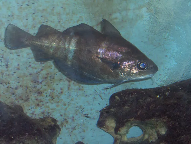 PoutingRegular local target1 placeBudleigh SaltertonOver beach
- Small-spotted catsharkRegular local target1 placeBudleigh SaltertonOver beach
 Atlantic mackerelSeasonal1 placeBudleigh SaltertonOver beachAround Jun–Sept
 Ballan wrasseRecorded here1 placeBudleigh SaltertonOver beach
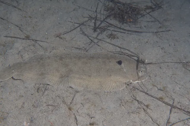 Common soleRecorded here1 placeBudleigh SaltertonOver beach
 Conger eelRecorded here1 placeBudleigh SaltertonOver beach
 PollackRecorded here1 placeBudleigh SaltertonOver beach
Also documented from the shore: Thick-lipped grey mullet
What these strengths mean
- Regular local target
- Fishing sources describe this as a normal local target here, not merely as caught.
- Seasonal
- Well supported, and concentrated in part of the year rather than spread through it.
- Recorded here
- At least one credible public account of this species being caught here. That is all it means.
- How breadth is counted
- A fish documented at six marks is shown as six marks: breadth never raises the strength on its own. A fishery account describes the fishing; a recorded catch reports one specific catch. How evidence is weighed.
Fish documented nearby, not here
Nothing below has been documented at Budleigh Salterton itself. Each one has been documented at a named place on the same ground, and the places are listed with it. Treat this as what the water around here holds rather than as a catch list for this mark.
Widely documented on this ground
Documented at three or more neighbouring places, fished a way this place is also fished. That is a pattern about the ground rather than about any one mark, and it is the closest this site comes to saying you will probably meet a fish somewhere nothing has been written about.
From the shore
- European sea bass — documented at Prawle Point; Bolt Head and the Salcombe rock; Seaton beach and the Axe mouth (+10 more)
- European flounder — documented at The Salcombe estuary; Exmouth and the Exe estuary; Teignmouth (+1 more)
- European plaice — documented at The Salcombe estuary; Seaton beach and the Axe mouth; Slapton Sands and Torcross (+2 more)
- Black seabream — documented at Hopes Nose; The Salcombe estuary; Seaton beach and the Axe mouth (+1 more)
- Garfish — documented at Babbacombe and Oddicombe; Hopes Nose; Brixham breakwater (+1 more)
Also documented at neighbouring places
One or two accounts each, on the ground around here. Enough to know the fish is caught in these waters; not enough to say anything about this place.
From the shore
- Whiting — documented at Babbacombe and Oddicombe; Hopes Nose
- Gilthead bream — documented at The Salcombe estuary; Slapton Sands and Torcross
- Atlantic cod — documented at Hopes Nose
- Striped red mullet — documented at Hopes Nose
- Thornback ray — documented at The Salcombe estuary
- Dab — documented at Seaton beach and the Axe mouth
- Turbot — documented at Bolt Head and the Salcombe rock
- Atlantic horse mackerel — documented at Brixham breakwater
- Starry smooth-hound — documented at Slapton Sands and Torcross
How people fish it
Practised here: Sea fishing.
Methods the sources name for this ground. Each one is explained in full on its own page.
- Surfcasting
Casting heavy baited tackle from a beach into surf — a method defined by distance, by tide, and by reading water that all looks the same.
- Ledgering
Fishing a bait on the bottom held by a weight, with no float — the simplest way to fish at distance, in depth, or in wind.
- Float fishing
Suspending a bait at a controlled depth beneath a buoyant indicator — the most visual, most controllable and most widely applicable method in angling.
Baits and lures for these fish
The baits and lures each of the fish above is commonly taken on, from that fish’s own page. This is what works for the fish, not a report of what people use on this particular water — local knowledge and the conditions on the day still decide.
Baits
- Fish strip and cut bait — for Bull huss, Small-spotted catshark, Conger eel, Thick-lipped grey mullet
- Ragworm — for Small-spotted catshark, Ballan wrasse, Pollack
- Squid and cuttlefish — for Bull huss, Small-spotted catshark, Conger eel
- Sea deadbaits — for Bull huss, Small-spotted catshark
- Bread — for Thick-lipped grey mullet
- Crab and shellfish — for Ballan wrasse
- Prawns and shrimp — for Ballan wrasse
- Sand eel — for Pollack
Lures
- Metal jigs — for Atlantic mackerel, Pollack
- Soft plastics — for Ballan wrasse, Pollack
- Jigs and jig heads — for Pollack
- Spinners — for Atlantic mackerel
The ground and the water
- The ground
- A steep bank of large rounded quartzite pebbles at the Otter mouth, dropping quickly into deep water with no shallow margin at all. The pebbles are the famous part: they are the far-travelled cobbles that end up on Chesil.
- Exposure
- Open south into Lyme Bay.
- Depth
- Steep-to: the pebble bank drops away and there is depth within a short cast.
Through the year
Mackerel in summer; dogfish and pouting through the year.
Safety
Cliffs and rock platforms — Can cause serious injury or death
Atlantic groundswell arrives from storms thousands of miles away, on days that are locally calm and sunny, and it comes in sets in which one wave runs far higher than the rest. Anglers are swept from rock platforms that had been dry for twenty minutes, into deep water with no shelf to climb out onto and frequently with a long, hard climb back to the access path.
What reduces it: Check the swell forecast rather than the wind forecast; watch any mark for a long period before committing, and assume the sets you have seen are not the largest; never fish rock alone; wear a buoyancy aid; and plan the exit for the sea state you might have rather than the one you arrived in.
Worse when:
- Any Atlantic swell forecast on the north coast, regardless of local wind
- Rising tide, which brings the sets progressively higher up the platform
- Descents that are hard to reverse, wet rock and weed, and darkness
- Stretches with no mobile coverage, where raising the alarm is not possible
Moving water and currents — Can cause serious injury or death
The north coast's surf beaches carry strong rip currents, which run seaward through gaps in the sandbars and can take a wading angler off their feet and out beyond the surf line faster than they can walk back.
What reduces it: Do not wade deep in surf; learn to identify the calmer, darker, less-breaking channels that mark a rip and stay out of them; and if caught, do not swim against it — swim across the current parallel to the beach until out of it.
Rules and access
FishingHQ does not know the current access position here. Shore angling in England is not rod-licensed, but access rights, landowner permission, local authority and harbour byelaws, national and inshore fisheries measures, and site designations all apply and all change. Check the current position with the relevant inshore fisheries and conservation authority, the harbour or local authority, and the landowner before going.
Who holds the answer:
- The Inshore Fisheries and Conservation Authority for the district, which makes and enforces inshore byelaws.
- The Marine Management Organisation, for national recreational sea fishing measures in English waters.
- The local authority and, where one exists, the harbour authority, for access, byelaws and shellfish classification.
- The national fisheries authority for England, for licensing of freshwater and migratory fishing and for fisheries enforcement
- The relevant inshore fisheries and conservation authority for the district, which sets and enforces local sea fisheries byelaws
- The body managing any marine protected area on the stretch concerned
- The local authority environmental health service, for shellfish classification and public health closures
- The harbour authority for working harbours and quays
- The relevant estuary or river management body, where an estuary carries its own arrangements
Nearby fishing
Other publicly documented places within about 40 km, by distance. Positions are approximate public geography and are never exact marks.
- Exmouth and the Exe estuary — 5–10 km · Estuary
- Sidmouth — 5–10 km · Beach
- Teignmouth — 10–25 km · Estuary mark
- Seaton beach and the Axe mouth — 10–25 km · Beach
- Babbacombe and Oddicombe — 10–25 km · Pier
- Hopes Nose — 10–25 km · Headland
- Torquay harbour — 10–25 km · Harbour wall
- Berry Head — 25–40 km · Headland
Sources for this place
- Sea Angler — Bauer Media (Specialist angling publication)Relied on for: Long-running published description of British sea angling practice by region, ground type and named mark.FishingHQ's interpretation of what it saysCitation checked — the work exists and is described correctly
- General angling website restatements of established technique — Various (Credible secondary source)Relied on for: Widely restated public descriptions of which places are conventionally fished and how, recorded as practitioner consensus rather than as scholarship, and not relied on for access, permission or any current rule.Background and mechanism onlyCitation checked — the work exists and is described correctly
- British Sea Fishing: south coast and south-west England shore marks — British Sea Fishing (Credible secondary source)Relied on for: Which species are fished for at each named shore mark on the English south and south-west coast, and in which season.States this directlyPassage read and verified
How FishingHQ labels evidence is explained in the evidence policy. Last reviewed 2026-08-16.