Victoria
Fishing regions · Last reviewed 2026-10-23
One state licence for the sea, the lakes and the rivers, a set of marine national parks where no fishing is allowed, and two big bays fished from public piers.
Fishing here at a glance
- Ways to fish
- From the shore · From a boat
- Plan a trip
- When is best · Baits and lures to bring · Open the trip planner · What the conditions mean
- Tide and weather
The official pages for this area’s readings. FishingHQ shows no live reading: check them for the day you go.
- Rules and access
- Who sets the rules here — being listed is never permission to fish.
Not documented here yet: tackle shops, charters or guides.
Being listed here is not permission to fish. What that meansClose
Access, fishing rights, seasons, licences, local bylaws and permitted methods vary and can change. Check current access, permission, local regulations, closures and restrictions before you travel or fish. FishingHQ describes what the ground is and names who holds the answer; it does not hold the answer itself.
Find the authority for a jurisdiction · What FishingHQ does and does not cover
Victoria is a state guide rather than a coast, because in Australia the state sets the fishing rules and the first question a visitor asks is the state's to answer.
ONE LICENCE COVERS EVERYTHING. The state's recreational fishing licence covers its marine waters, lakes and rivers alike, and it is valid only in Victoria. The Victorian Fisheries Authority issues it. The state lists who does not need one; everybody else does, whether they fish from a pier, a boat or a riverbank.
THE LICENCE IS NOT THE WHOLE ANSWER. Catch limits, size limits and closed seasons are set by the Victorian Fisheries Authority and published in its recreational fishing guide, and they change. Marine national parks and marine sanctuaries lie along the bays and the open coast, and fishing is prohibited in them from the shore and at sea. Whether a pier or jetty is open is its operator's decision. And on eleven stretches of ocean rock, from Cape Bridgewater to Kilcunda, a lifejacket must be worn.
SEA OR FRESH IS DECIDED AT THE MOUTH. Victoria counts a river as inland water from its mouth all the way to its source, so the lower reaches of a river, salty or not, are under the inland rules; the Gippsland Lakes, Lake Tyers, Wingan Inlet and the lower lake of Mallacoota Inlet count as marine. The agency draws the boundary on maps for several rivers.
THE TWO BAYS THE AGENCY DESCRIBES. Port Phillip and Western Port are described spot by spot: public piers and jetties with the fish it lists at each, the tides and methods it recommends, and the parking, toilets, shelters and ramps beside them. They differ. Port Phillip is a large bay closed to the ocean except at the Heads; Western Port is strongly tidal, with deep channels, and the agency warns of the current at San Remo.
WHAT THIS GUIDE DOES NOT COVER YET. The state's inland waters — its rivers, lakes and reservoirs — are under the same licence, but the agency's inland guides have not yet been read here, so no inland place is described.
What fishing here is like
A temperate state facing Bass Strait, with two large bays south of Melbourne — Port Phillip, closed to the ocean but for a narrow entrance, and Western Port, shallow, tidal and channelled around Phillip Island and French Island — and an exposed ocean coast either side of them. Inland, rivers, lakes and reservoirs under the same state licence.
What you can target here
One entry per fish, grouped by how you would be fishing — because the answer is a different one from the rocks and from a boat. Each entry says how strongly the sources support it and how much evidence sits behind it. These are documented catches, not a forecast, and none of it is a statement that you may fish any particular ground.
From the shore · 13
- Yellow-eye mulletRegular local target18 placesQueenscliff Pier, Werribee River mouth, Ferguson Street Pier, Mordialloc Pier and 14 moreOver bay, beach, bridge, estuary, estuary mark, jetty, pierAround Mar–Sept
- Silver trevallyRegular local target17 placesQueenscliff Pier, Cunningham Pier, Werribee River mouth, Ferguson Street Pier and 13 moreOver bay, estuary, estuary mark, jetty, pierAround Jan–May, Oct–Dec
- King George whitingRegular local target16 placesQueenscliff Pier, Cunningham Pier, Mordialloc Pier, Mornington Pier and 12 moreOver bay, beach, estuary mark, jetty, pierAround Jan–Apr, Nov–Dec
- Australasian snapperRegular local target10 placesCunningham Pier, Ferguson Street Pier, Mordialloc Pier, Mornington Pier and 6 moreOver bay, jetty, pierAround Jan–May, Oct–Dec
- Estuary perchRegular local target8 placesTooradin Inlet, Hopkins River estuary, The Blue Hole, Hopkins River, Hopkins Point Road bridge and 4 moreOver bridge, estuary, estuary mark, jetty
- Black breamRegular local target7 placesHopkins River estuary, The Blue Hole, Hopkins River, Hopkins Point Road bridge, Lyndoch platforms, Hopkins River and 3 moreOver bridge, estuary, estuary mark, jetty
Also documented from the shore: Dusky kob · Barracouta · Gummy shark · Elephant fish · Brown trout · Rainbow trout · Yellowtail kingfish
From a boat · 4
- Black breamRegular local target1 placeHopkins River estuaryOver estuary
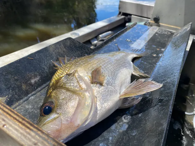 Estuary perchRegular local target1 placeHopkins River estuaryOver estuary
Photo: Bryce Watts-Parker, via iNaturalist, CC BY; resized
- Yellow-eye mulletRegular local target1 placeHopkins River estuaryOver estuary
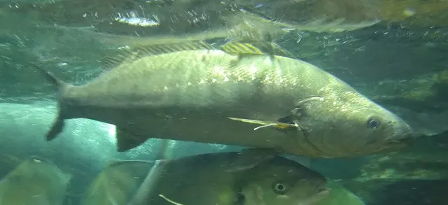 Dusky kobSeasonal1 placeHopkins River estuaryOver estuaryAround Jan–May, Sept–Dec
Photo: タウナギ, via Wikimedia Commons, CC BY-SA 4.0; resized and trimmed to fit; shared under the same licence

What these strengths mean
- Regular local target
- Fishing sources describe this as a normal local target here, not merely as caught.
- Seasonal
- Well supported, and concentrated in part of the year rather than spread through it.
- How breadth is counted
- A fish documented at six marks is shown as six marks: breadth never raises the strength on its own. A fishery account describes the fishing; a recorded catch reports one specific catch. How evidence is weighed.
How people fish here
5 methods are recorded on the places documented here, counted from those places themselves rather than from what is practised in the country. Each opens a full guide to the technique.
Ledgering
Recorded at 26 places here, over jetty, pier, estuary, bay.
Fishing a bait on the bottom held by a weight, with no float — the simplest way to fish at distance, in depth, or in wind.
Documented on the same ground: Australasian snapper, Barracouta, Black bream, Dusky kob, Elephant fish, Estuary perch.
Float fishing
Recorded at 12 places here, over pier, jetty, bay, estuary.
Suspending a bait at a controlled depth beneath a buoyant indicator — the most visual, most controllable and most widely applicable method in angling.
Documented on the same ground: Australasian snapper, Black bream, Dusky kob, Estuary perch, King George whiting, Silver trevally.
Eging
Recorded at 11 places here, over pier, jetty, bay.
Jigging for squid and cuttlefish with a barbed, weighted lure worked in lifts and pauses — a Japanese discipline with its own tackle, vocabulary and competitive scene.
Documented on the same ground: Australasian snapper, Barracouta, Elephant fish, Gummy shark, King George whiting, Silver trevally.
Spinning
Recorded at 11 places here, over pier, bay, estuary, jetty.
Casting an artificial lure and retrieving it so that it moves like something alive — the most direct form of lure fishing.
Documented on the same ground: Australasian snapper, Barracouta, Black bream, Dusky kob, Estuary perch, King George whiting.
Trolling
Recorded at 1 place here, over estuary.
Towing lures or baits behind a moving boat to cover large volumes of water and locate scattered fish.
Documented on the same ground: Black bream, Estuary perch, Yellow-eye mullet, Dusky kob.
These are the methods documented at the places FishingHQ holds here. A species listed beside a method is documented on the same ground, which is not the same as being taken that way — where a source establishes the method a fish was caught on, it is stated on that place’s own page. All fishing methods.
Baits and lures for these fish
The methods, baits and lures each of the fish above is commonly taken on, from that fish’s own page. This is what works for the fish, not a report of what people use on this particular water — local knowledge and the conditions on the day still decide.
Methods
- Float-tube fishing — for Brown trout, Rainbow trout
- Jigging — for Silver trevally, Yellowtail kingfish
- Livebaiting at sea — for Dusky kob, Yellowtail kingfish
- Drift fishing — for Australasian snapper
- Dry fly fishing — for Brown trout
- Kayak fishing — for Yellowtail kingfish
- Nymphing — for Rainbow trout
- Popping and stickbaiting — for Estuary perch
Also: Salmon fly fishing · Stillwater fly fishing · Surfcasting · Tenkara
Baits
- Maggots — for Brown trout
Lures
- Dry flies — for Brown trout, Rainbow trout
- Metal jigs — for Australasian snapper, Yellowtail kingfish
- Nymphs — for Brown trout, Rainbow trout
- Soft plastics — for Silver trevally, Australasian snapper
- Streamers — for Brown trout, Rainbow trout
- Spinners — for Rainbow trout
- Surface lures — for Yellowtail kingfish
- Terrestrial fly patterns — for Brown trout
Also: Wet flies
The fishing year here
The months the places and accounts under this area actually name, tightest season first. This is “observed in these months” rather than a season: a species whose months nobody recorded is not listed, because a gap in the evidence is not a year-round fishery.
- Elephant fishMarch to May
- King George whitingNovember to April
- Yellow-eye mulletMarch to September
- Silver trevallyOctober to May
- Australasian snapperOctober to May
- Gummy sharkMarch to October
- Dusky kobSeptember to May
What dominates
Shore fishing from the public piers and jetties of the two bays, with bait and with jigs for squid; small-boat fishing in the bays; night fishing on the tide for gummy shark in Western Port, which the state agency describes. Freshwater fishing in the rivers and lakes is licensed by the state too, and is not yet described here.
The water available
Port Phillip's sheltered bay piers and jetties over sand, seagrass and reef; Western Port's tidal channels, mudflats and seagrass; river mouths entering the bays; the open Bass Strait coast; and inland rivers, lakes and reservoirs.
How the rules are structured
Victoria licenses recreational fishing in all its waters with a single state licence, covering marine waters, lakes and rivers, valid only in Victoria and issued by the Victorian Fisheries Authority under the state's fisheries regulations. When its licence page was read on 22 and 23 October 2026, the state listed as not needing one: people under 18 or over 70, people identifying as Aboriginal or Torres Strait Islander, and holders of particular seniors, veterans and pensioner concession cards that the page names. Catch limits, size limits and closed seasons are set by the Victorian Fisheries Authority and published in its recreational fishing guide and app; they change, and FishingHQ does not restate them. Fishing is prohibited from the shore and at sea in marine national parks and marine sanctuaries, which are managed by Parks Victoria; the state's fishing guide app shows whether you are in, approaching or outside one, and spear guns are not permitted in any of Victoria's marine protected areas. Victoria counts a waterway as inland from its mouth to its source, so an estuary is inland water, while the Gippsland Lakes, Lake Tyers, Wingan Inlet and the lower lake of Mallacoota Inlet are marine; the inland and marine rules differ. The intertidal zone, from the high-water mark to two metres deep, is protected: in Port Phillip Bay only worms, burrowing shrimp, squid, octopus and cuttlefish may be taken from it, elsewhere a wider list, and no hand-held digging tool may be used. At eleven listed high-risk rock zones on the ocean coast a lifejacket must be worn when fishing. A pier or jetty being public is not a statement that it is open or that fishing from it is allowed today. FishingHQ does not state what any current rule is: what is said here is what the state's pages said when read, and the state's page is the authority. Check the current position with the Victorian Fisheries Authority before going.
Who to ask
- The Victorian Fisheries Authority, which issues the recreational fishing licence and sets and publishes the catch limits, size limits and closed seasons.
- Service Victoria, the state's service through which the licence is bought.
- Parks Victoria, which manages the marine national parks and marine sanctuaries where fishing is prohibited.
- The operator of a pier or jetty, for whether it is open.
Words you will meet
- Marine national park
- In Victoria, a marine protected area where fishing from the shore or at sea is prohibited. A boat may carry fish caught elsewhere through one under conditions Parks Victoria states.
- Inland and marine waters
- Victoria's division of its waters for the rules. A river is inland from its mouth to its source, estuary included; a few named coastal lakes and inlets are marine.
- Intertidal zone
- In Victoria, from the high-water mark to where the water is two metres deep. It is protected: only listed animals may be collected there, by listed methods.
- Marine sanctuary
- A smaller marine protected area in Victoria, also closed to fishing; the state's fishing guide app shows where they are.
Conditions and hazards
The bays are sheltered water, but not uniformly. The state agency warns of strong currents at Sorrento and at San Remo, where heavy sinkers are needed except around slack water, of Cowes Jetty's exposure in strong northerly winds, and of boat traffic in the Werribee River. The open ocean coast is a different place from the bays: several people drown each year after being swept off rocks, the agency says, and it requires a lifejacket at eleven high-risk rock zones. Sun and dehydration are a routine hazard across the state.
Do you need a fishing licence in Victoria?
Almost certainly, unless you are in a group the state names as not needing one.
ONE LICENCE, ALL WATERS. Victoria's recreational fishing licence covers marine waters, lakes and rivers. There is no separate freshwater licence (though the inland and marine rules differ, and Victoria counts an estuary as inland water), and a licence from another state does not count: the Victorian licence is valid only in Victoria. The Victorian Fisheries Authority issues it, and it is bought through Service Victoria.
WHO THE STATE SAYS DOES NOT NEED ONE. When FishingHQ read the state's licence page on 22 and 23 October 2026 it listed people under 18 or over 70, people identifying as Aboriginal or Torres Strait Islander, and holders of particular seniors, veterans and pensioner concession cards, which the page names card by card. That list is the state's, and it can change; check it on the day rather than here.
WHAT IT DOES NOT TELL YOU. A licence is one requirement among several; it says nothing about catch limits, closed ground, or whether a particular pier is open. Those are the next three questions.
Official guidance — why, and the sources (2)
Stated by a fisheries authority, scientific institute or recognised angling body. Authoritative, but summarising rather than demonstrating.
- Buy a Victorian recreational fishing licence — Service Victoria (State Government of Victoria) (Local authority, harbour or protected-area body)Relied on for: That a licence is needed for recreational fishing in Victorian waters, covering lakes, rivers and marine waters, valid only in Victoria and issued by the Victorian Fisheries Authority, and the categories of people the state lists as not needing one.States this directlyPassage read and verified
- Water definitions — Victorian Fisheries Authority (Government fisheries body)Relied on for: How Victoria divides inland from marine water: a waterway is inland from its mouth to its source, five named lakes and inlets are marine, and farm dams are neither.States this directlyPassage read and verified
Where the current rules are kept, and what closes ground to fishing
CATCH AND SIZE LIMITS, AND CLOSED SEASONS. The Victorian Fisheries Authority sets them and publishes them in its recreational fishing guide — the 2026 edition when read, in print from licence-selling tackle shops, in the VicFishing app and online. FishingHQ does not copy them, because it does not watch them change; look them up for the fish and the water you intend to fish.
INLAND OR MARINE? The guide's rules differ between the two, and the line between them is the mouth of the river: upstream of it is inland water, even where the tide reaches.
MARINE NATIONAL PARKS AND SANCTUARIES. Fishing from the shore or at sea is prohibited in them. Parks Victoria says a boat may carry finfish caught outside a park and an unused rod through one, and some shellfish with the gear stowed if travelling straight through by the shortest route, and that spear guns are not permitted in any of Victoria's marine protected areas. The state's fishing guide app uses your position to show whether you are in, approaching or outside one, which matters on a coast where a park can start partway along a beach.
BAIT FROM THE SHORE. The intertidal zone, from the high-water mark to two metres deep, is protected. In Port Phillip Bay only marine worms, burrowing shrimp, squid, octopus and cuttlefish may be taken from it — not crabs, pipis or mussels; elsewhere the list is longer. No hand-held digging tool may be used in it anywhere, so pipis, worms and bass yabbies are not dug; a bait pump of the permitted size is allowed.
PIERS AND JETTIES. A structure being public does not mean it is open today or that fishing from it is allowed; its operator decides.
WHAT FISHINGHQ CANNOT TELL YOU. Whether any rule has changed since these pages were read, or what applies at a particular spot today. The authorities below can.
Official guidance — why, and the sources (6)
Stated by a fisheries authority, scientific institute or recognised angling body. Authoritative, but summarising rather than demonstrating.
- Recreational Fishing Guide — Victorian Fisheries Authority (Government fisheries body)Relied on for: That the state's limits, permitted equipment and restricted waters are published in its 2026 recreational fishing guide, in print, in the VicFishing app and online.States this directlyPassage read and verified
- Go Fishing — Port Phillip Bay — Victorian Fisheries Authority (Government fisheries body)Relied on for: The state agency's account of Port Phillip's public fishing spots, fish, methods, amenities and local warnings.States this directlyPassage read and verified
- Port Phillip Heads Marine National Park — Parks Victoria (Conservation authority)Relied on for: That fishing from the shore or at sea is prohibited in a marine national park, what a boat may carry through one, and that spear guns are not permitted in any of Victoria's marine protected areas.States this directlyPassage read and verified
- Churchill Island Marine National Park — Parks Victoria (Local authority, harbour or protected-area body)Relied on for: That the state's recreational fishing guide app shows whether the user is in, approaching or outside a marine national park or sanctuary.States this directlyPassage read and verified
- Intertidal zone fishing restrictions — Victorian Fisheries Authority (Government fisheries body)Relied on for: That Victoria's intertidal zone is protected, what may and may not be collected there in Port Phillip Bay and elsewhere, and that hand-held digging implements are prohibited.States this directlyPassage read and verified
- Water definitions — Victorian Fisheries Authority (Government fisheries body)Relied on for: How Victoria divides inland from marine water: a waterway is inland from its mouth to its source, five named lakes and inlets are marine, and farm dams are neither.States this directlyPassage read and verified
Rock fishing, and Victoria's lifejacket zones
The Victorian Fisheries Authority says several people drown each year after being swept off rocks, and requires a lifejacket at eleven high-risk zones on the ocean coast, a rule kept after a two-year trial. Fines apply.
THE ZONES, AS LISTED WHEN READ. The rock platform near the blowholes car park at Cape Bridgewater; Artillery Rocks and Jump Rock near Lorne, and the platform opposite Sheoak Falls; all rock platforms between Point Nepean and West Head near Cape Schanck; Pyramid Rocks, Kitty Miller Bay, Cowries Rock and Sunderland Bay on Phillip Island; all rock platforms between Bore Beach at San Remo and Kilcunda; and Point Roadknight at Anglesea. The agency publishes maps of each.
EVERYWHERE ELSE, THE SAME ADVICE. The agency asks rock fishers to wear a lifejacket wherever they are.
IF SOMEBODY IS WASHED IN. Do not jump in after them. Throw a rope or anything that floats, call 000 or 112, and stay back from the edge. Someone in the water should swim away from the rocks and wait for help or a safe place to get out.
The piers and jetties of the two bays are not in these zones; the ocean side of Phillip Island and the coast east of San Remo are.
Official guidance — why, and the sources (1)
Stated by a fisheries authority, scientific institute or recognised angling body. Authoritative, but summarising rather than demonstrating.
- Rock fishing safety — Victorian Fisheries Authority (Government fisheries body)Relied on for: The coastal zones where a lifejacket must be worn when rock fishing, that fines apply, and what to do if someone is washed in.States this directlyPassage read and verified
Fishing the two bays from the agency's own guides
The Victorian Fisheries Authority publishes a guide to each of the two bays south of Melbourne, spot by spot, and they are the source of every Victorian place on FishingHQ.
PORT PHILLIP. Eight public spots, mostly piers, from Queenscliff and Geelong round to Mornington and Sorrento, each with the fish the agency lists there, how they are fished, and the amenities at the foot of the pier. It warns of strong currents at Sorrento and boat traffic at the Werribee River mouth.
WESTERN PORT. Nine spots — piers, jetties and one beach — around the bay and Phillip Island. It is a tidal bay with deep channels, and the agency warns that the current at San Remo Jetty is very strong except around slack water and that Cowes Jetty is exposed to strong northerlies. It describes night fishing on the rising tide around the full and new moon for gummy shark, with Merricks Beach as its named spot, and the deep channel at Corinella for gummy shark and elephant fish.
The places themselves, with the fish, methods and amenities for each, are listed below.
Official guidance — why, and the sources (2)
Stated by a fisheries authority, scientific institute or recognised angling body. Authoritative, but summarising rather than demonstrating.
- Go Fishing — Port Phillip Bay — Victorian Fisheries Authority (Government fisheries body)Relied on for: The state agency's account of Port Phillip's public fishing spots, fish, methods, amenities and local warnings.States this directlyPassage read and verified
- Go Fishing — Western Port — Victorian Fisheries Authority (Government fisheries body)Relied on for: The state agency's account of Western Port's public fishing spots, fish, tides, methods, amenities and local warnings.States this directlyPassage read and verified
Places within this area
Publicly documented fishing geography. FishingHQ describes what the ground is; it does not say whether you may fish it, and every one of these sends that question to the body that holds the answer. Browse every place in this part of the world.
Who to ask before fishing any of these
FishingHQ does not know the current access position here. Victoria licenses recreational fishing in its marine waters, with exemptions the state lists; bag limits, size limits and closed seasons are set by the Victorian Fisheries Authority and change. Marine national parks and marine sanctuaries lie along the bays and coast, and their boundaries are shown by the state's fishing guide app. A pier or jetty being public is not a statement that fishing from it is allowed today. Check the current position with the Victorian Fisheries Authority before going.
FishingHQ does not know the current access position here. Victoria licenses recreational fishing in its marine waters, with exemptions the state lists; bag limits, size limits and closed seasons are set by the Victorian Fisheries Authority and change. Marine national parks and marine sanctuaries lie along the bays and coast, and their boundaries are shown by the state's fishing guide app. A pier or jetty being public is not a statement that fishing from it is allowed today. Check the current position with the Victorian Fisheries Authority before going. This water is tidal and transitional, so the freshwater regime may also apply above the tidal limit: FishingHQ does not know the current access position here. Victoria's recreational fishing licence also covers its lakes and rivers, and the state sets their limits and seasons, which change. Check the current position with the Victorian Fisheries Authority before going.
FishingHQ does not know the current access position here. Victoria's recreational fishing licence also covers its lakes and rivers, and the state sets their limits and seasons, which change. Check the current position with the Victorian Fisheries Authority before going.
Port Phillip Bay
Bay · Salt water
The large, almost enclosed bay south of Melbourne, with Geelong on its western arm and the Mornington Peninsula along its east. The state agency's guide numbers eight public spots on it: piers at Queenscliff, Geelong, Williamstown, Mordialloc, Mornington and Sorrento, and the mouths of the Werribee and Patterson rivers. It also names St Kilda, Kerford Road, Brighton and Beaumaris piers as places for particular fish.
Particular to this water: The state's fishing guide app shows the boundaries of the marine national parks and sanctuaries in and around the bay, which the agency's guide does not mark. Check them before fishing anywhere not named here.
Western Port
Bay · Salt water
The large tidal bay east of the Mornington Peninsula, enclosing French Island, with Phillip Island across its mouth. The state agency's guide numbers nine public spots around it: jetties and piers at Flinders, Stony Point, Hastings, Corinella, San Remo, Rhyll and Cowes, the inlet at Tooradin and the beach at Merricks.
Severe hazards of Victoria apply here: cliffs and rock platforms.
Particular to this water: Marine national parks lie in Western Port, among them Churchill Island Marine National Park south of Rhyll, and the state's fishing guide app shows their boundaries. Check them before fishing anywhere not named here.
Hopkins River estuary
Estuary · Brackish water
A salt-wedge estuary at Warrnambool, about nine kilometres from the mouth at Point Ritchie to the rock barrier at Tooram Stones, with sand and mud flats, weed beds, reefs, rock walls and deep holes. The agency gives black bream, estuary perch, mulloway, yellow eye mullet, Australian salmon and short-finned eel as its key fish, with twenty shore and boat access points along it.
Sheltered river water, but its mouth closes in low summer and autumn flows, when the agency says deep holes can lose oxygen and fish move onto the shallower weed beds and flats.
Particular to this ground: boat safety, boat traffic and being seen.
Particular to this water: Under Victoria's water definitions a river is inland water from its mouth upstream, so the Hopkins estuary is fished under the inland rules. A recreational bait net may be used only between Rowans Lane and 200 m from the mouth, and catch limits apply to bait. The estuary marks the border of the Kirrae Whurrong, Gunditjmara and Tjap Whurrong peoples; the short-finned eel, kuuyang, is a powerful cultural symbol for the Gunditjmara.
Devilbend Reservoir
Reservoir · Fresh water
A former water-supply reservoir at Tuerong on the Mornington Peninsula, inside the Devilbend Natural Features Reserve, which Parks Victoria manages. The agency reports a fishing and viewing platform funded partly from licence fees and designated fishing zones shown on its map.
Particular to this water: Fish only in the designated fishing zones the agency's map shows. The picnic area car park is open to vehicles from sunrise to sunset and to walkers at all hours, as the agency's page states.
Safety
Further safety reading
- Rock platform and cliff safety — A lifejacket must be worn at eleven high-risk rock zones on Victoria's ocean coast, from Cape Bridgewater to Kilcunda.
Check the rules before you fish
Fishing laws, bylaws, access rules, seasons, bait restrictions and permitted methods vary by location and can change. Check the current rules from the relevant authority and the water you intend to fish before fishing.
Check with:
- Current national or regional law for where you are fishing
- Current local bylaws
- The relevant fisheries authority
- The landowner, club or fishery whose water it is
- Any restrictions specific to the species or the method you intend to use
Where to go next
Rules and access
- Licences and permissionOne state licence covers Victoria's marine waters, lakes and rivers; the state lists who does not need one, and the licence is not permission to fish a particular water.
More fishing regions
Not related to this page — just the rest of the section. There is little else joined to this subject yet, and a short page should still lead somewhere.
Sources and evidence
7 sources cited on this page
- Buy a Victorian recreational fishing licence — Service Victoria (State Government of Victoria) (Local authority, harbour or protected-area body)Relied on for: That a licence is needed for recreational fishing in Victorian waters, covering lakes, rivers and marine waters, valid only in Victoria and issued by the Victorian Fisheries Authority, and the categories of people the state lists as not needing one.States this directlyPassage read and verified
- Recreational Fishing Guide — Victorian Fisheries Authority (Government fisheries body)Relied on for: That the state's limits, permitted equipment and restricted waters are published in its 2026 recreational fishing guide, in print, in the VicFishing app and online.States this directlyPassage read and verified
- Water definitions — Victorian Fisheries Authority (Government fisheries body)Relied on for: How Victoria divides inland from marine water: a waterway is inland from its mouth to its source, five named lakes and inlets are marine, and farm dams are neither.States this directlyPassage read and verified
- Port Phillip Heads Marine National Park — Parks Victoria (Conservation authority)Relied on for: That fishing from the shore or at sea is prohibited in a marine national park, what a boat may carry through one, and that spear guns are not permitted in any of Victoria's marine protected areas.States this directlyPassage read and verified
- Rock fishing safety — Victorian Fisheries Authority (Government fisheries body)Relied on for: The coastal zones where a lifejacket must be worn when rock fishing, that fines apply, and what to do if someone is washed in.States this directlyPassage read and verified
- Go Fishing — Port Phillip Bay — Victorian Fisheries Authority (Government fisheries body)Relied on for: The state agency's account of Port Phillip's public fishing spots, fish, methods, amenities and local warnings.States this directlyPassage read and verified
- Go Fishing — Western Port — Victorian Fisheries Authority (Government fisheries body)Relied on for: The state agency's account of Western Port's public fishing spots, fish, tides, methods, amenities and local warnings.States this directlyPassage read and verified
Why the 2 connections on this page are here, and the sources
Safety reading
Official guidance — 1 connection
Stated by a fisheries authority, scientific institute or recognised angling body. Authoritative, but summarising rather than demonstrating.
Rock platform and cliff safety
The state fisheries agency's own rock-fishing page.
- Rock fishing safety — Victorian Fisheries Authority (Government fisheries body)Relied on for: The high-risk rock zones where a lifejacket must be worn, and the agency's statement that several people drown each year after being swept off rocks.States this directlyPassage read and verified
Rules and access
Official guidance — 1 connection
Stated by a fisheries authority, scientific institute or recognised angling body. Authoritative, but summarising rather than demonstrating.
Licences and permission
The state's own licence page.
- Buy a Victorian recreational fishing licence — Service Victoria (State Government of Victoria) (Local authority, harbour or protected-area body)Relied on for: That a licence is needed for recreational fishing in all Victorian waters, with listed exemptions, issued by the Victorian Fisheries Authority.States this directlyPassage read and verified
How FishingHQ labels evidence is explained in the evidence policy.