Tasmania
Fishing regions · Last reviewed 2026-10-25
No licence for a rod and line at sea, a licence for pots, nets, set lines, abalone and scallops, and a separate angling licence for every inland water, farm dams included.
Fishing here at a glance
- Ways to fish
- From the shore · From a boat
- Set up for
Rod to hook from each fish’s guide, and how to build its rigs.
- Tide and weather
The official pages for this area’s readings. FishingHQ shows no live reading: check them for the day you go.
- Rules and access
- Who sets the rules here — being listed is never permission to fish.
Not documented here yet: tackle shops, charters or guides.
Being listed here is not permission to fish. What that meansClose
Access, fishing rights, seasons, licences, local bylaws and permitted methods vary and can change. Check current access, permission, local regulations, closures and restrictions before you travel or fish. FishingHQ describes what the ground is and names who holds the answer; it does not hold the answer itself.
Find the authority for a jurisdiction · What FishingHQ does and does not cover
Tasmania is a state guide rather than a coast, because the state sets the fishing rules, and its answer to the first question a visitor asks differs from the mainland's.
AT SEA, THE ROD NEEDS NO LICENCE. Rod and line fishing in Tasmania's marine waters needs no licence. What does need one is particular fisheries and gear: rock lobster by pot, ring or diving, abalone, scallops, graball, mullet and beach seine nets, and set lines. The state's licensing year runs from 1 November.
INLAND, EVERY ROD NEEDS ONE. Anyone 14 or over fishing with a rod, reel or line in any inland water needs an angling licence from the Inland Fisheries Service, a different agency with its own licence year from 1 August, and that includes a farm dam on private land.
THE LINE BETWEEN THEM IS THE SEAWARD LIMIT. Each river has a declared point, usually a bridge, road or white posts, above which inland rules apply. On the Tamar and the Derwent the inland water reaches a long way down the estuary.
THE LICENCE IS NOT THE WHOLE ANSWER. Seasons, size, bag and possession limits, gear rules and closed areas apply on both sides of the line, and change. FishingHQ does not copy them; it says where each is kept.
What fishing here is like
An island state across Bass Strait from the mainland, with an estuary-and-bay sea fishery around its coast and a trout fishery in its rivers and highland lakes, licensed and regulated by two different agencies.
What you can target here
One entry per fish, grouped by how you would be fishing — because the answer is a different one from the rocks and from a boat. Each entry says how strongly the sources support it and how much evidence sits behind it. These are documented catches, not a forecast, and none of it is a statement that you may fish any particular ground.
From the shore · 5
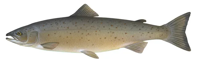 Atlantic salmonRegular local target1 placeMacquarie HarbourOver bay
Illustration: Knepp, Timothy, via Wikimedia Commons, public domain; resized and trimmed to fit
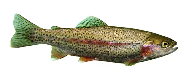 Rainbow troutRegular local target1 placeMacquarie HarbourOver bay
Photo: Jonathunder, via Wikimedia Commons, CC BY-SA 3.0; resized and trimmed to fit; shared under the same licence
- BarracoutaRepeatedly reported2 placesThe Tamar estuary, Tasmania, The Derwent estuaryOver estuary
- Australasian snapperRepeatedly reported1 placeKing IslandOver island
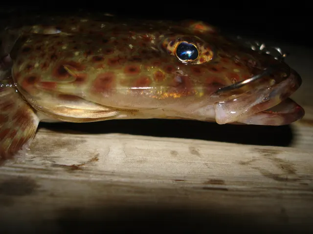 Sand flatheadRecorded here3 placesKing Island, The Derwent estuary, The Tamar estuary, TasmaniaOver estuary, island
Photo: NicoDesSables, via Wikimedia Commons, CC BY-SA 3.0; resized; shared under the same licence


From a boat · 12
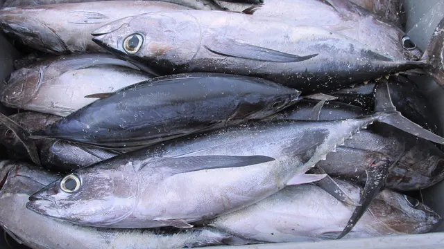 AlbacoreRegular local target1 placeSchouten Passage and Schouten IslandOver sea area
Photo: Joachim Langeneck, via Wikimedia Commons, CC BY-SA 4.0; resized and trimmed to fit; shared under the same licence
- Atlantic salmonRegular local target1 placeMacquarie HarbourOver bay
Illustration: Knepp, Timothy, via Wikimedia Commons, public domain; resized and trimmed to fit
- Rainbow troutRegular local target1 placeMacquarie HarbourOver bay
Photo: Jonathunder, via Wikimedia Commons, CC BY-SA 3.0; resized and trimmed to fit; shared under the same licence
- Sand flatheadRegular local target1 placeGreat Oyster BayOver bay
Photo: NicoDesSables, via Wikimedia Commons, CC BY-SA 3.0; resized; shared under the same licence
- Tiger flatheadRegular local target1 placeGreat Oyster BayOver bay
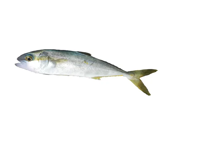 Yellowtail kingfishSeasonal2 placesThe Derwent estuary, The Tamar estuary, TasmaniaOver estuaryAround Jan–Feb, Dec
Photo: Hugues Evano (IFREMER, Délégation océan Indien (DOI), Département Ressources Biologiques et Environnement (RBE), F-97420 Le Port, France), via Wikimedia Commons, CC BY 4.0; resized


Also documented from a boat: Barracouta · Australasian snapper · King George whiting · Blue shark · Striped trumpeter · Yellowfin tuna
What these strengths mean
- Regular local target
- Fishing sources describe this as a normal local target here, not merely as caught.
- Seasonal
- Well supported, and concentrated in part of the year rather than spread through it.
- Repeatedly reported
- Several independent public accounts. Enough to say it happens more than once; not enough to call it a fishery.
- Recorded here
- At least one credible public account of this species being caught here. That is all it means.
- Occasional
- Caught here, and described as unusual rather than normal. Do not plan a session around it.
- How breadth is counted
- A fish documented at six marks is shown as six marks: breadth never raises the strength on its own. A fishery account describes the fishing; a recorded catch reports one specific catch. How evidence is weighed.
How people fish here
3 methods are recorded on the places documented here, counted from those places themselves rather than from what is practised in the country. Each opens a full guide to the technique.
Drift fishing
Recorded at 1 place here, over bay.
Letting the boat move with tide and wind while fishing, so the tackle searches ground instead of waiting on it — and the decision that determines whether a boat session works at all.
Documented on the same ground: Sand flathead, Tiger flathead, Barracouta.
Spinning
Recorded at 1 place here, over bay.
Casting an artificial lure and retrieving it so that it moves like something alive — the most direct form of lure fishing.
Documented on the same ground: Atlantic salmon, Rainbow trout.
Trolling
Recorded at 1 place here, over sea area.
Towing lures or baits behind a moving boat to cover large volumes of water and locate scattered fish.
Documented on the same ground: Albacore, Blue shark, Striped trumpeter, Yellowfin tuna.
These are the methods documented at the places FishingHQ holds here. A species listed beside a method is documented on the same ground, which is not the same as being taken that way — where a source establishes the method a fish was caught on, it is stated on that place’s own page. All fishing methods.
Baits and lures for these fish
The methods, baits and lures each of the fish above is commonly taken on, from that fish’s own page. This is what works for the fish, not a report of what people use on this particular water — local knowledge and the conditions on the day still decide.
Methods
- Livebaiting at sea — for Albacore, Yellowtail kingfish, Blue shark
- Big-game fishing — for Blue shark
- Float-tube fishing — for Rainbow trout
- Jigging — for Yellowtail kingfish
- Kayak fishing — for Yellowtail kingfish
- Ledgering — for Striped trumpeter
- Nymphing — for Rainbow trout
- Salmon fly fishing — for Atlantic salmon
Also: Stillwater fly fishing
Lures
- Metal jigs — for Yellowtail kingfish, Australasian snapper, Yellowfin tuna
- Streamers — for Atlantic salmon, Rainbow trout
- Dry flies — for Rainbow trout
- Nymphs — for Rainbow trout
- Saltwater lures — for Yellowfin tuna
- Soft plastics — for Australasian snapper
- Spinners — for Rainbow trout
- Spoons — for Atlantic salmon
Also: Surface lures · Wet flies
What dominates
Shore and boat fishing with rod and line in the estuaries and bays, which needs no licence; licensed fisheries for rock lobster, abalone and scallops, by pot, ring, net or diving; and trout fishing in the rivers and lakes under the Inland Fisheries Service's angling licence.
The water available
Estuaries, bays and harbours around the coast; open coast; rivers whose lower reaches are inland water down to a declared seaward limit; and highland lakes and reservoirs, some open all year.
How the rules are structured
Two agencies divide Tasmania's waters at the seaward limit declared on each river. Downstream, the state's marine fisheries service, Fishing Tasmania, sets the sea rules and grants its licences under the Living Marine Resources Management Act 1995: when its licence page was read on 25 October 2026, it said rod and line fishing at sea needs no licence and that a recreational sea licence is needed for rock lobster, abalone, scallops, graball, mullet and beach seine nets and set lines, with most not available to children under 10; Aboriginal fishers need no recreational sea licence but may need a unique identifying code. It publishes seasons for several fisheries, size, bag and possession limits, gear and bait rules and area restrictions — marine reserves, research areas, shark refuge areas, seasonal calamari closures and marine farm leases — on its site, in the Fishing Tas app and in its printed guide. Upstream, the Inland Fisheries Service licenses angling under the Inland Fisheries Act 1995 and the Inland Fisheries Regulations 2019: anyone 14 or over needs its angling licence to fish any inland water, farm dams included, with exceptions for registered private fisheries, native fish in specified waters and a child under 14 with one rod, and a separate licence for whitebait. Inland seasons differ by water and are listed in the Tasmanian Inland Fishing Code. Recreational catch may not be sold. FishingHQ does not state what any current rule is: what is said here is what the agencies' pages said when read, and their pages are the authority.
Who to ask
- Fishing Tasmania, the state's marine fisheries service, which issues recreational sea licences and publishes the sea fishing rules, seasons and area restrictions.
- The Inland Fisheries Service, which issues the inland angling licence and publishes the inland seasons and rules in the Tasmanian Inland Fishing Code.
- Service Tasmania, whose shops sell both agencies' licences.
Words you will meet
- Seaward limit
- In Tasmania, the declared boundary on each river between inland water, under the Inland Fisheries Service, and marine water downstream. It is usually marked by a bridge, road or white posts.
- Excepted waters
- A stretch the Inland Fisheries Service treats as marine water but where an inland licence is still needed to take trout, as on the Derwent above a boundary it describes.
- Shark refuge area
- A Tasmanian sea area where the state restricts the gear that may be used and the species that may be taken.
- Brown trout and rainbow trout waters
- The Inland Fisheries Service's two main kinds of season. Most waters open in early August and close around the end of April; designated rainbow trout waters open around October and close around the end of May.
Conditions and hazards
Neither agency's page read for this guide states a hazard for the whole state, so none is given here. The places listed below carry the hazards their own sources state, and the Australian guidance on the open coast, sun and weather applies.
Do you need a fishing licence in Tasmania?
It depends on which side of the seaward limit you fish, and how.
AT SEA WITH A ROD: NO. Fishing Tasmania's licence page, read on 25 October 2026, says rod and line fishing in marine waters needs no licence.
AT SEA WITH OTHER GEAR: OFTEN. The same page lists the fisheries that do need a recreational sea licence: rock lobster by pot, ring or diving, abalone, scallops, graball nets, mullet nets, beach seine nets and set lines. Most are not available to children under 10. Aboriginal fishers do not need a recreational sea licence but may need a unique identifying code. The licensing year it showed ran from 1 November 2026 to 31 October 2027, and it said plastic licence cards are not issued.
IN FRESH WATER: YES, FROM 14. The Inland Fisheries Service's page says anyone aged 14 or over needs a current angling licence to fish with a rod, reel or line in any inland water in Tasmania, including a farm dam on private property. It lists three exceptions: a registered private fishery, native fish in waters the regulations specify, and a child under 14 fishing with a single rod. Whitebait needs a licence of its own. The inland licence year runs from 1 August, and short licences are sold as well as whole seasons.
THE FEES are on the two agencies' pages and are not restated here.
Official guidance — why, and the sources (2)
Stated by a fisheries authority, scientific institute or recognised angling body. Authoritative, but summarising rather than demonstrating.
- Recreational Sea Fishing Licences — Fishing Tasmania (Department of Natural Resources and Environment Tasmania) (Government fisheries body)Relied on for: That rod and line fishing in Tasmania's marine waters needs no licence; which sea fisheries and gear do; that Aboriginal fishers need no recreational sea licence; and that freshwater fishing is licensed separately by Inland Fisheries.States this directlyPassage read and verified
- Angling Licence — Inland Fisheries Service, Tasmania (Government fisheries body)Relied on for: Who needs an inland angling licence, where, the exceptions, the licence year and the law it is issued under.States this directlyPassage read and verified
Sea or fresh: where the seaward limit falls
The Inland Fisheries Service regulates every water upstream of the seaward limit declared on its river; downstream, the marine rules apply. The limit is usually marked by a bridge, a road or white posts, and in some places is known only by map coordinates, which the InFish app shows.
THE TWO BIG ESTUARIES. On kanamaluka, the Tamar, the limit is a line across the river at Haystack Point; on the Derwent, a line from Dogshear Point. Above them the estuary is inland water, and the service lists the Tamar below the named bridges and the Derwent below New Norfolk Bridge among the waters open all year. On the Derwent it also describes excepted waters: marine water upstream of a boundary between Dowsings Point and Store Point, where an inland licence is still needed to take trout.
WHY IT MATTERS. A rod that needs no licence below the line needs the inland angling licence above it, and the rules on seasons and methods change at the same point.
Official guidance — why, and the sources (2)
Stated by a fisheries authority, scientific institute or recognised angling body. Authoritative, but summarising rather than demonstrating.
- The Seaward Limit — Inland Fisheries Service, Tasmania (Government fisheries body)Relied on for: Where inland rules give way to marine rules, how the boundary is marked, and the Derwent's excepted waters.States this directlyPassage read and verified
- Season Dates and Times — Inland Fisheries Service, Tasmania (Government fisheries body)Relied on for: How inland seasons are organised between brown trout waters, rainbow trout waters and waters open all year.States this directlyPassage read and verified
Where the current rules are kept
AT SEA. Fishing Tasmania publishes the seasons, the size, bag and possession limits, the gear and bait rules and the area restrictions on its website, in the Fishing Tas app and in the printed Recreational Sea Fishing Guide. When read, its season table covered rock lobster and giant crab by region, squid and calamari in the south-east and on the north coast, scallops, striped trumpeter, garfish in northern and southern waters, and banded morwong. Its area restrictions cover marine reserves, where fishing by any method is generally prohibited, research areas, shark refuge areas, seasonal calamari closures on the north and east coasts, net and line restrictions and marine farm leases; the app maps them on the water.
INLAND. The Inland Fisheries Service publishes the season and fishing times for each water in the Tasmanian Inland Fishing Code and the InFish app. Most waters are brown trout waters, open from the first Saturday of August to the Sunday nearest 30 April; designated rainbow trout waters open from the Saturday nearest 1 October to the Sunday nearest 31 May; some waters are open all year; and some restrict fishing to between an hour before sunrise and three hours after sunset.
SELLING THE CATCH. Recreationally caught fish may not be sold, bought, bartered or raffled.
WHAT FISHINGHQ CANNOT TELL YOU. Whether any of this has changed since it was read, or what applies at a particular spot today. The two agencies can.
Official guidance — why, and the sources (5)
Stated by a fisheries authority, scientific institute or recognised angling body. Authoritative, but summarising rather than demonstrating.
- Recreational Fishing Rules — Fishing Tasmania (Department of Natural Resources and Environment Tasmania) (Government fisheries body)Relied on for: Where the state keeps its sea fishing limits, gear rules and bait rules, and that recreational catch may not be sold.States this directlyPassage read and verified
- Recreational Fishing Seasons — Fishing Tasmania (Department of Natural Resources and Environment Tasmania) (Government fisheries body)Relied on for: Which sea fisheries the state gives open and closed seasons.States this directlyPassage read and verified
- Area Restrictions — Fishing Tasmania (Department of Natural Resources and Environment Tasmania) (Government fisheries body)Relied on for: The kinds of area restriction the state applies at sea, and that its app maps them.States this directlyPassage read and verified
- Season Dates and Times — Inland Fisheries Service, Tasmania (Government fisheries body)Relied on for: How inland seasons are organised between brown trout waters, rainbow trout waters and waters open all year.States this directlyPassage read and verified
- Angling Licence — Inland Fisheries Service, Tasmania (Government fisheries body)Relied on for: Who needs an inland angling licence, where, the exceptions, the licence year and the law it is issued under.States this directlyPassage read and verified
Places within this area
Publicly documented fishing geography. FishingHQ describes what the ground is; it does not say whether you may fish it, and every one of these sends that question to the body that holds the answer. Browse every place in this part of the world.
Who to ask before fishing any of these
FishingHQ does not know the current access position here. Tasmania sets its own sea fishing rules: bag, possession and size limits that differ by zone for some fish, a seasonal closure for at least one species, shark refuge areas where sharks, skates and rays may not be taken, marine reserves where no fishing is allowed, and licences for some kinds of gear. The state also publishes health advice against eating fish or shellfish from named estuaries. All of it changes. Check the current position with Fishing Tasmania before going.
FishingHQ does not know the current access position here. Tasmania sets its own sea fishing rules: bag, possession and size limits that differ by zone for some fish, a seasonal closure for at least one species, shark refuge areas where sharks, skates and rays may not be taken, marine reserves where no fishing is allowed, and licences for some kinds of gear. The state also publishes health advice against eating fish or shellfish from named estuaries. All of it changes. Check the current position with Fishing Tasmania before going. This water is tidal and transitional, so the freshwater regime may also apply above the tidal limit: FishingHQ does not know the current access position here. Tasmania licenses freshwater fishing separately from sea fishing, with its own seasons and waters. Check the current position with the state's fisheries authorities before going.
King Island
Island · Salt water
An island in Bass Strait off north-west Tasmania, fished from its beaches and from public jetties. The Tasmanian government's fishing guide says it has some of the best land-based fishing in the state, with jetty access at Naracoopa and at Currie Harbour, and describes many of its fishing areas as remote.
Severe hazards of Tasmania apply here: cliffs and rock platforms.
Particular to this water: The state's page for the island says netting is not allowed in most of its rivers and estuaries. The state's own species guide describes fishing for sand flathead as highly unsustainable in most of Tasmania and sets limits for it zone by zone. It asks anglers to fish for a mixed bag of other species instead.
The Derwent estuary
Estuary · Brackish water
The estuary of the River Derwent at Hobart, fished from a long list of public shore spots on both banks, among them the Tasman Bridge, Sandy Bay, Taroona, Kingston, Blackmans Bay and the jetties at South Arm and Opossum Bay.
Particular to this water: The state's page says the River Derwent is a shark refuge area, where sharks, skates and rays other than elephantfish may not be taken, and it carries public-health advice not to eat shellfish or bream from the estuary, and to limit other fish, because of heavy metal contamination. The state's own species guide describes fishing for sand flathead as highly unsustainable in most of Tasmania and sets limits for it zone by zone. It asks anglers to fish for a mixed bag of other species instead.
The Tamar estuary, Tasmania
Estuary · Brackish water
The long tidal estuary of the Tamar, kanamaluka, in northern Tasmania, running to the sea at Low Head. Its public fishing spots include Greens Beach, Kelso Jetty, Beauty Point Wharf, the Deviot pontoon, George Town and the Low Head pilot station. A specialist list from 2008 reports squid from Kelso Jetty at dawn and dusk, a rock ledge at West Head inside a national park where an entry fee applied, and boat fishing in the main river below Windermere and Rosevears in less than ten metres of water.
Particular to this water: The state's page says the Tamar is a shark refuge area, where sharks, skates and rays other than elephantfish may not be taken, and carries public-health advice not to eat wild shellfish from the estuary because of heavy metal contamination. The state's own species guide describes fishing for sand flathead as highly unsustainable in most of Tasmania and sets limits for it zone by zone. It asks anglers to fish for a mixed bag of other species instead.
Great Oyster Bay
Bay · Salt water
A large, sheltered bay on Tasmania's east coast between Swansea and the Freycinet Peninsula, mostly flat sand in ten to fifteen metres. Boats drift it for flathead. From the shore the articles report squid taken on jigs from the main piers at Swansea and Coles Bay, especially in the evening, with small Australian salmon, long-fin pike and mackerel off the same jetties, fishing from the western side beside the highway, and bream in the Swan River north of Swansea.
Severe hazards of Tasmania apply here: cliffs and rock platforms.
Particular to this water: This record rests on articles from 2008 and 2013 and describes what was reported then. Nothing here states that a spot is open or can still be reached. Tasmania's sea fishing rules, area restrictions and closed seasons are set by the state and change: check the current position with Fishing Tasmania before fishing. The 2013 article describes the whole bay as a reserve in which every shark landed must be returned, and size and possession limits for flathead; those are its statements as of its date.
Schouten Passage and Schouten Island
Sea area · Salt water
A deep channel with strong currents between the Freycinet Peninsula and Schouten Island, at the seaward end of Great Oyster Bay, and the open water round the island beyond it. The 2008 article says heavy sinkers are needed to fish the bottom in the passage, and that the southern tip and eastern shores of the island are the most productive for tuna. It is a run of fifteen kilometres or more from the ramps in the bay.
The passage runs hard, and the water beyond it is open to the Tasman Sea; the article gives the length of the run as the reason more boats do not make it.
Particular to this water: This record rests on articles from 2008 and 2013 and describes what was reported then. Nothing here states that a spot is open or can still be reached. Tasmania's sea fishing rules, area restrictions and closed seasons are set by the state and change: check the current position with Fishing Tasmania before fishing. The island and the peninsula are inside a national park.
The Frederick Henry Bay shore
Bay · Salt water
The northern shore of a large bay east of Hobart. A 2008 list reports five shore spots here, in its own words: Seven Mile Beach for flathead, salmon and whiting; the Midway Point causeway, early or in the evening, for salmon, trevally and elephant fish; Lewisham jetty for flathead, cod and salmon; the first point west of the ramp at Dodges Ferry for flathead, cod and whiting; and Primrose Point to Connellys Marsh for squid, flathead, cod and salmon. None of those names identifies one species in Tasmania, so no fish is attached to this place.
Severe hazards of Tasmania apply here: cliffs and rock platforms.
Particular to this water: This record rests on articles from 2008 and 2013 and describes what was reported then. Nothing here states that a spot is open or can still be reached. Tasmania's sea fishing rules, area restrictions and closed seasons are set by the state and change: check the current position with Fishing Tasmania before fishing. A heritage survey describes the old stone jetty at Lewisham as a ruin, so the jetty the list names may not be there to fish from.
Macquarie Harbour
Bay · Brackish water
A very large, almost enclosed harbour on Tasmania's west coast, entered from Strahan. The 2008 list says it is best explored by boat, with headlands, bays and rivers to choose from, and that its most sought-after fish are large rainbow trout and Atlantic salmon — escapes from the harbour's fish farms and an established wild population.
Particular to this water: This record rests on articles from 2008 and 2013 and describes what was reported then. Nothing here states that a spot is open or can still be reached. Tasmania's sea fishing rules, area restrictions and closed seasons are set by the state and change: check the current position with Fishing Tasmania before fishing.
Check the rules before you fish
Fishing laws, bylaws, access rules, seasons, bait restrictions and permitted methods vary by location and can change. Check the current rules from the relevant authority and the water you intend to fish before fishing.
Check with:
- Current national or regional law for where you are fishing
- Current local bylaws
- The relevant fisheries authority
- The landowner, club or fishery whose water it is
- Any restrictions specific to the species or the method you intend to use
Where to go next
Rules and access
- Licences and permissionRod and line fishing at sea needs no licence in Tasmania; particular sea fisheries and gear do, and every inland water needs the Inland Fisheries Service's angling licence from age 14. Neither licence is permission to fish a particular water.
More fishing regions
Not related to this page — just the rest of the section. There is little else joined to this subject yet, and a short page should still lead somewhere.
Sources and evidence
7 sources cited on this page
- Recreational Sea Fishing Licences — Fishing Tasmania (Department of Natural Resources and Environment Tasmania) (Government fisheries body)Relied on for: That rod and line fishing in Tasmania's marine waters needs no licence; which sea fisheries and gear do; that Aboriginal fishers need no recreational sea licence; and that freshwater fishing is licensed separately by Inland Fisheries.States this directlyPassage read and verified
- Angling Licence — Inland Fisheries Service, Tasmania (Government fisheries body)Relied on for: Who needs an inland angling licence, where, the exceptions, the licence year and the law it is issued under.States this directlyPassage read and verified
- The Seaward Limit — Inland Fisheries Service, Tasmania (Government fisheries body)Relied on for: Where inland rules give way to marine rules, how the boundary is marked, and the Derwent's excepted waters.States this directlyPassage read and verified
- Recreational Fishing Rules — Fishing Tasmania (Department of Natural Resources and Environment Tasmania) (Government fisheries body)Relied on for: Where the state keeps its sea fishing limits, gear rules and bait rules, and that recreational catch may not be sold.States this directlyPassage read and verified
- Recreational Fishing Seasons — Fishing Tasmania (Department of Natural Resources and Environment Tasmania) (Government fisheries body)Relied on for: Which sea fisheries the state gives open and closed seasons.States this directlyPassage read and verified
- Area Restrictions — Fishing Tasmania (Department of Natural Resources and Environment Tasmania) (Government fisheries body)Relied on for: The kinds of area restriction the state applies at sea, and that its app maps them.States this directlyPassage read and verified
- Season Dates and Times — Inland Fisheries Service, Tasmania (Government fisheries body)Relied on for: How inland seasons are organised between brown trout waters, rainbow trout waters and waters open all year.States this directlyPassage read and verified
Why the 1 connections on this page are here, and the sources
Rules and access
Official guidance — 1 connection
Stated by a fisheries authority, scientific institute or recognised angling body. Authoritative, but summarising rather than demonstrating.
Licences and permission
The state marine fisheries service's own licence page.
- Recreational Sea Fishing Licences — Fishing Tasmania (Department of Natural Resources and Environment Tasmania) (Government fisheries body)Relied on for: That rod and line fishing in marine waters needs no licence, which sea fisheries do, and that freshwater fishing is licensed separately.States this directlyPassage read and verified
How FishingHQ labels evidence is explained in the evidence policy.