The Norfolk Broads
Fishing regions · Last reviewed 2026-08-14
A network of shallow lakes and slow rivers that everybody assumed was natural until the 1950s, when it turned out to be flooded medieval peat diggings — and one of Britain's great pike fisheries.
Safety: drowning and immersion — can cause serious injury or death. One more point applies here.
Being listed here is not permission to fish. What that meansClose
Access, fishing rights, seasons, licences, local bylaws and permitted methods vary and can change. Check current access, permission, local regulations, closures and restrictions before you travel or fish. FishingHQ describes what the ground is and names who holds the answer; it does not hold the answer itself.
Find the authority for a jurisdiction · What FishingHQ does and does not cover
The Broads are a connected system of shallow lakes — the broads themselves — joined by slow lowland rivers across Norfolk and Suffolk, and their most remarkable fact is that they are entirely man-made.
UNTIL THE 1950S THEY WERE ASSUMED TO BE NATURAL. Research then established that the broads are flooded medieval peat diggings: enormous excavations dug over centuries to supply fuel to a densely populated and largely treeless region, subsequently flooded as sea levels rose and the diggings became untenable. The straight edges and the abrupt depth changes that had puzzled people turned out to be the walls of the pits. It is one of the more satisfying pieces of landscape history in Britain, and it makes the Broads a wholly artificial landscape now protected as a national park.
THE WATER IS SHALLOW, SLOW AND BRACKISH IN PLACES. The rivers — Bure, Yare, Waveney, Thurne, Ant and their tributaries — are tidal well inland, and salinity intrudes on the lower reaches, which shapes both the fish community and the occasional catastrophe.
IT IS ONE OF BRITAIN'S GREAT PIKE FISHERIES, with a reputation built on very large fish, particularly on the Thurne system. It also holds bream, roach, rudd, tench and perch in quantity, and the lower reaches hold flounder and mullet.
AND IT IS ECOLOGICALLY FRAGILE. Nutrient enrichment stripped much of the system of its clear-water plant communities in the twentieth century; restoration work has recovered some broads and not others. Saline incursion events have caused large fish kills on the Thurne. Boat traffic is heavy. The Broads are a working demonstration that a much-loved landscape can also be a damaged one.
What fishing here is like
A connected network of shallow man-made lakes and slow tidal rivers across a low-lying landscape, protected as a national park and used very heavily for boating. The fishing is predominantly coarse, the pike fishery has a national reputation, and access is a mixture of free river bank, club water, day-ticket fisheries and water reachable only by boat.
The culture is a boating one as much as an angling one, and the two share the water closely.
What you can target here
One entry per fish, grouped by how you would be fishing — because the answer is a different one from the rocks and from a boat. Each entry says how strongly the sources support it and how much evidence sits behind it. These are documented catches, not a forecast, and none of it is a statement that you may fish any particular ground.
From the shore · 6
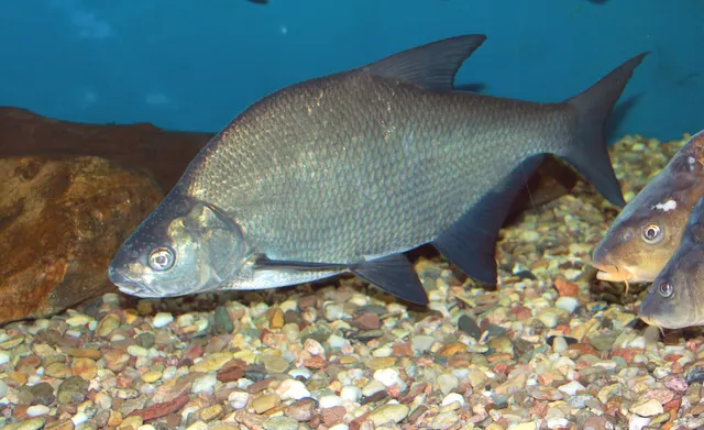 Common breamCharacteristic of this water3 placesBarton Broad, Wroxham Broad, Ormesby BroadOver broadAround Jun–Sept
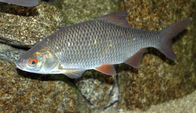 RoachRegular local target3 placesBarton Broad, Wroxham Broad, Ormesby BroadOver broad
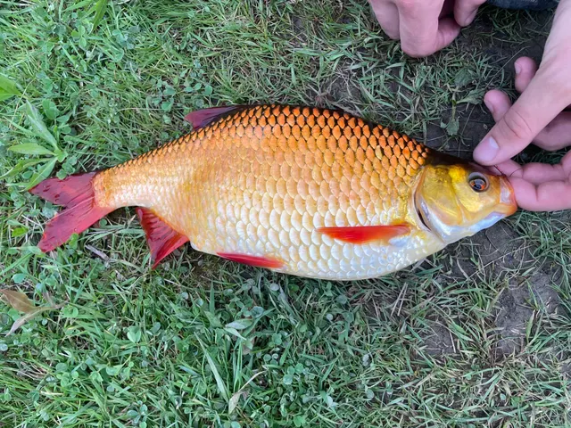 RuddRegular local target3 placesOrmesby Broad, Barton Broad, Wroxham BroadOver broad
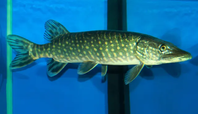 Northern pikeSeasonal3 placesBarton Broad, Wroxham Broad, Ormesby BroadOver broadAround Jan–Feb, Oct–Dec
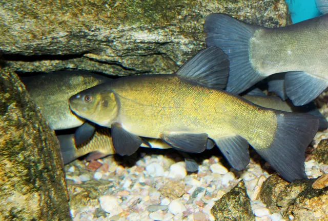 TenchSeasonal3 placesBarton Broad, Wroxham Broad, Ormesby BroadOver broadAround Jun–Sept
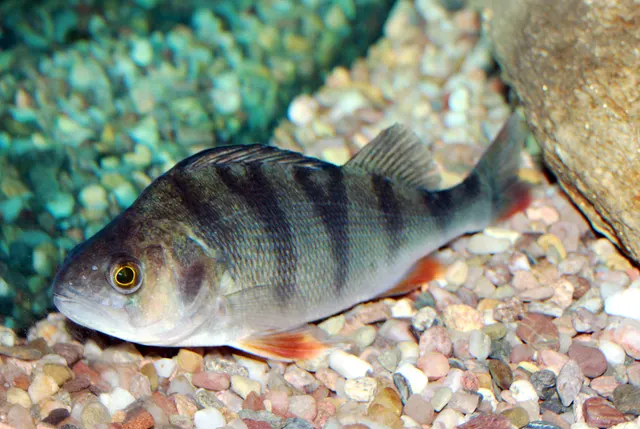 European perchRecorded here3 placesBarton Broad, Wroxham Broad, Ormesby BroadOver broad
From a boat · 3
What these strengths mean
- Characteristic of this water
- This water is strongly identified with this species by the sources that cover it.
- Regular local target
- Fishing sources describe this as a normal local target here, not merely as caught.
- Seasonal
- Well supported, and concentrated in part of the year rather than spread through it.
- Recorded here
- At least one credible public account of this species being caught here. That is all it means.
- How breadth is counted
- A fish documented at six marks is shown as six marks: breadth never raises the strength on its own. A fishery account describes the fishing; a recorded catch reports one specific catch. How evidence is weighed.
How people fish here
5 methods are recorded on the places documented here, counted from the records themselves rather than from what is practised in the country. Each opens a full guide to the technique.
Float fishing
Recorded at 6 places here, over broad, river reach.
Suspending a bait at a controlled depth beneath a buoyant indicator — the most visual, most controllable and most widely applicable method in angling.
Documented on the same ground: Common bream, Roach, Rudd, Northern pike, Tench, European perch.
Deadbaiting
Recorded at 4 places here, over broad, river reach.
Presenting a dead fish as bait for predators — a method that works because scavenging is normal predator behaviour, not an exception.
Documented on the same ground: Common bream, Roach, Rudd, Northern pike, Tench, European perch.
Spinning
Recorded at 4 places here, over broad, river reach.
Casting an artificial lure and retrieving it so that it moves like something alive — the most direct form of lure fishing.
Documented on the same ground: Common bream, Roach, Rudd, Northern pike, Tench, European perch.
Ledgering
Recorded at 3 places here, over broad, river reach.
Fishing a bait on the bottom held by a weight, with no float — the simplest way to fish at distance, in depth, or in wind.
Documented on the same ground: Common bream, Roach, Northern pike, Tench, European perch, Rudd.
Feeder fishing
Recorded at 2 places here, over broad, river reach.
Legering with a weight that also carries bait, so that free offerings arrive in exactly the same place as the hookbait, cast after cast.
Documented on the same ground: Common bream, Roach, Northern pike, Tench, European perch, Rudd.
These are the methods documented at the places FishingHQ holds here. A species listed beside a method is documented on the same ground, which is not the same as being taken that way — where a source establishes the method a fish was caught on, it is stated on that place’s own page. All fishing methods.
The fishing year here
The months the records under this area actually name, tightest season first. This is “observed in these months” rather than a season: a species whose months nobody recorded is not listed, because a gap in the evidence is not a year-round fishery.
- Common breamJune to September
- TenchJune to September
- Northern pikeOctober to February
What dominates
Pike fishing, principally on deadbait and lure from bank and boat, which is the system's headline fishery and its national reputation. Bream and roach fishing on the rivers and broads, historically a major match and pleasure fishery. Tench and rudd fishing on the quieter broads. Lure fishing for pike and perch, which has grown substantially. Boat fishing generally, since a good deal of the system is reachable only by boat. Sea fishing interest on the lower tidal reaches for flounder and mullet.
The water available
Shallow lakes — the broads — averaging only a few metres deep, many with abrupt edges where the peat cutting stopped. Slow lowland rivers, tidal well inland, connecting them. Reed and sedge fen margins, extensively designated. Grazing marsh and drainage dyke networks. Brackish influence on the lower reaches, with salinity intruding upriver on some systems. Extensive navigation with heavy boat traffic in season.
How the rules are structured
A national rod licence for England is required for freshwater fishing and comes from the national fisheries authority. Permission for the specific water is separate: some river banks carry long-standing open arrangements, some water is club-controlled, some is day ticket, and some broads are private or accessible only by boat. The navigation authority administers the waterways and boat use, including registration and speed limits, and has its own byelaws. A statutory close season applies on rivers and on some other waters and does not apply everywhere in the system, which is a common source of confusion. Extensive conservation designations cover much of the fen, marsh and open water for habitat and species interest. Some broads and channels are closed to navigation or to access entirely for conservation reasons. Biosecurity requirements apply and matter in a connected system of this kind. FishingHQ does not state what any current rule is: obtain the national licence, establish the permission for the specific water, and check the navigation authority's byelaws if using a boat.
Who to ask
- The national fisheries authority for England, for the rod licence, close seasons and statutory rules
- The Broads navigation authority, for boat registration, speed limits, moorings and waterway byelaws
- The angling club, fishery or landowner controlling the specific water, where it is not free river bank
- The statutory nature conservation body, for the extensive designations covering fen, marsh and open water
- The local internal drainage board, for the dyke and drainage network that connects much of the system
Words you will meet
- Broad
- One of the shallow lakes of the system. Now known to be a flooded medieval peat digging rather than a natural lake, which explains their abrupt edges and uniform depths.
- Staithe
- A public landing place or quay on the waterways. Staithes are frequently the practical access points for anglers as well as boaters, and the word appears constantly in local place names.
- Prymnesium
- The alga responsible for the catastrophic fish kills on the Thurne system, which blooms in brackish conditions and produces a toxin lethal to fish. Local anglers use the name directly.
- Dyke
- A drainage channel. The Broads landscape is threaded with them, some are fishable, and they connect the system in ways that matter for both fish movement and biosecurity.
Conditions and hazards
The Broads look benign and the hazards are correspondingly underestimated.
The rivers are tidal well inland, with a real range and a real flow, and banks are frequently soft, reed-fringed and undercut with no firm edge at all. Falling in from a reed bank is easy and getting out is genuinely difficult.
Boat traffic is heavy in season and the channels are narrow; anglers on the bank and in small boats share the water with much larger hire craft whose crews are frequently inexperienced.
The water is shallow but the mud beneath it is deep and soft in places.
Winter fishing on exposed broads is cold and windy with little shelter.
Weil's disease is present as in any fresh water, and blue-green algal blooms occur on some broads in summer.
And navigation in a landscape this flat and this similar is harder than it looks, particularly in fog or failing light.
A landscape that turned out to be a target
The Broads' defining fact was established only in the 1950s: the broads are not natural lakes but FLOODED MEDIEVAL PEAT DIGGINGS.
A densely populated, largely treeless region needed fuel, and from roughly the twelfth century onward it dug peat on an enormous scale. As sea levels rose and the diggings flooded, the workings became untenable and were abandoned to water. The abrupt edges, the uniform depths and the straight boundaries that had long puzzled observers turned out to be the walls and floors of the pits.
WHAT THE SYSTEM IS PHYSICALLY: shallow lakes of only a few metres, connected by slow lowland rivers — Bure, Yare, Waveney, Thurne, Ant — which are tidal well inland. Reed and sedge fen at the margins, grazing marsh behind, and a network of drainage dykes threading the whole.
BRACKISH INFLUENCE reaches surprisingly far upstream on some systems, which shapes both the fish community and the occasional disaster.
AND IT IS A NATIONAL PARK — a wholly artificial landscape protected for its wildlife and its character, which is a slightly delicious contradiction and an entirely sound decision.
Backed by research — why, and the sources (2)
Supported by peer-reviewed research or fisheries science. The sources are listed and can be checked.
- JNCC species and habitat conservation advice — Joint Nature Conservation Committee (Conservation authority)Relied on for: Conservation status, designation and monitoring of species and habitats in the United Kingdom, including protected river and lake systems.States this directlyCitation checked — the work exists and is described correctly
- Fishers' Craft and Lettered Art: Tracts on Fishing from the End of the Middle Ages — University of Toronto Press, 1997 (Scientific literature)Relied on for: Medieval and early-modern European fishing practice, fishery organisation and the legal arrangements governing rivers and ponds.States this directlyCitation checked — the work exists and is described correctly
Pike above all, and a lot else besides
PIKE are the Broads' reputation. The system has produced very large fish over a long period, particularly on the Thurne, and it is one of the waters British pike anglers most want to fish. The combination of shallow rich water, abundant prey and brackish influence appears to suit them.
BREAM AND ROACH in quantity on the rivers and broads, historically supporting a major match and pleasure fishery.
TENCH AND RUDD on the quieter and clearer broads, with rudd in particular a Broads speciality.
PERCH throughout, and increasingly targeted on lures.
EELS historically in great numbers, now much reduced with the European stock.
FLOUNDER AND MULLET on the lower tidal reaches, which surprises visitors who think of the Broads as fresh water.
THE SEASON follows the English statutory pattern on rivers, with pike fishing at its best from autumn through winter, bream and tench in the warmer months, and the whole system quieter and far more pleasant to fish once the summer boat traffic has gone.
Backed by research — why, and the sources (2)
Supported by peer-reviewed research or fisheries science. The sources are listed and can be checked.
- Freshwater Fishes of the British Isles — HarperCollins (New Naturalist 75), 1992 (Reference work)Relied on for: Biology, distribution, life history and conservation status of British and Irish freshwater and diadromous fishes.States this directlyCitation checked — the work exists and is described correctly
- The Fishes of the British Isles and North-West Europe — Macmillan, 1969 (Reference work)Relied on for: Distribution, habitat and biology of the fishes of the British Isles and north-west Europe.States this directlyCitation checked — the work exists and is described correctly
How it is fished, and why a boat changes everything
PIKE FISHING on deadbait and lure, from bank and boat, is the system's signature. Winter is the traditional season and the water is at its best then.
BREAM AND ROACH FISHING on the rivers and broads, on feeder and float, which was historically the system's mass fishery.
TENCH AND RUDD on the quieter broads, often at dawn in the margins.
LURE FISHING for pike and perch, which has grown substantially and suits the reed edges and dyke mouths.
AND THE BOAT IS THE KEY. A very large part of the system is reachable only by boat, whether a dayboat, a hired craft or a small angling boat — and being afloat also solves the Broads' other problem, which is that the banks are frequently soft reed with nowhere to stand. A visitor restricted to the bank sees a fraction of the system.
SHARING THE WATER is part of fishing here. The navigation is busy in season with hire craft whose crews are often inexperienced, and that is a courtesy matter most of the time and occasionally a safety one.
What experienced anglers do — why, and the sources (2)
Widely and independently recommended by experienced anglers and specialist sources. This is real angling knowledge, not proof: controlled evidence for it is limited, and FishingHQ records it as convention rather than as a demonstrated effect.
- Angling Times — Bauer Media (Specialist angling publication)Relied on for: Contemporary UK coarse and match angling practice as reported by practitioners, including venue character and method convention.States this directlyCitation checked — the work exists and is described correctly
- Coarse Fishing — A. & C. Black, 1912 (Specialist angling publication)Relied on for: Classical British coarse angling practice: river and stillwater reading, baits, terminal arrangements and seasonal observation.States this directlyCitation checked — the work exists and is described correctly
A much-loved landscape that is also a damaged one
The Broads are a good example of somewhere that is simultaneously treasured and ecologically compromised, and an honest record has to hold both.
NUTRIENT ENRICHMENT through the twentieth century — from sewage and from agriculture — pushed many broads from clear water with rich plant communities into turbid, algae-dominated states. Rooted plants disappeared over large areas, taking the invertebrates and the fish community structure with them. Restoration work, including sediment removal and nutrient reduction, has recovered some broads convincingly and others not at all.
PRYMNESIUM is the Thurne system's particular disaster. This alga blooms in brackish conditions and produces a toxin lethal to fish; blooms have caused catastrophic fish kills, including of the very large pike the system is famous for. It is a local name every Broads angler knows.
BOAT TRAFFIC contributes bank erosion and turbidity, and is an active management question in a landscape whose economy depends on it.
AND THE HISTORY IS THE REDEEMING PART. A landscape created by industrial-scale extraction, abandoned, flooded, and now protected as a national park for its wildlife is a reminder that damaged places can become valuable ones — which is worth holding onto while reading the rest.
Official guidance — why, and the sources (2)
Stated by a fisheries authority, scientific institute or recognised angling body. Authoritative, but summarising rather than demonstrating.
- JNCC species and habitat conservation advice — Joint Nature Conservation Committee (Conservation authority)Relied on for: Conservation status, designation and monitoring of species and habitats in the United Kingdom, including protected river and lake systems.States this directlyCitation checked — the work exists and is described correctly
- Environment Agency fisheries management, byelaws and rod licensing information — Environment Agency (Government fisheries body)Relied on for: The structure of freshwater fisheries management in England, including licensing, close seasons, water quality monitoring and fishery regulation.States this directlyCitation checked — the work exists and is described correctly
The words of the Broads
BROAD names one of the shallow lakes, and now carries the knowledge that it is a flooded peat digging rather than a natural lake.
STAITHE names a public landing place or quay, appears throughout local place names, and is frequently the practical access point for an angler as well as a boater.
PRYMNESIUM names the alga responsible for the Thurne fish kills. Anglers here use the scientific name directly, which is unusual and tells you how significant the events were.
DYKE names a drainage channel — the system is threaded with them, some are fishable, and they connect the whole in ways that matter for fish movement and for biosecurity.
AND MARSH, FEN AND CARR distinguish the margin habitats: open grazing marsh, wet reed and sedge fen, and the scrubby wet woodland that colonises fen when it is not managed. Local descriptions of where to fish assume you know which is which.
What experienced anglers do — why, and the sources (2)
Widely and independently recommended by experienced anglers and specialist sources. This is real angling knowledge, not proof: controlled evidence for it is limited, and FishingHQ records it as convention rather than as a demonstrated effect.
- JNCC species and habitat conservation advice — Joint Nature Conservation Committee (Conservation authority)Relied on for: Conservation status, designation and monitoring of species and habitats in the United Kingdom, including protected river and lake systems.States this directlyCitation checked — the work exists and is described correctly
- Angling Times — Bauer Media (Specialist angling publication)Relied on for: Contemporary UK coarse and match angling practice as reported by practitioners, including venue character and method convention.States this directlyCitation checked — the work exists and is described correctly
Some of what lives here
Fish recorded here that FishingHQ holds a reviewed photograph of. It is not a complete list of what The Norfolk Broads holds, and it is not a prediction that you will catch any of them — it is a way in to the ones we can show you.
- Northern pikeThe dominant freshwater ambush predator of the northern hemisphere: long, cryptic, and built for one violent acceleration rather than pursuit.
Karelj, Public domain, via Wikimedia Commons
- Common breamA deep-bodied, slow-moving shoal fish that feeds in large groups over soft bottoms and can transform a swim when it arrives.
Karelj, Public domain, via Wikimedia Commons
Places within this area
Publicly documented fishing geography. FishingHQ describes what the ground is; it does not say whether you may fish it, and every one of these sends that question to the body that holds the answer. Browse every place in this part of the world.
Who to ask before fishing any of these
FishingHQ does not know the current access position here. Shore angling in England is not rod-licensed, but access rights, landowner permission, local authority and harbour byelaws, national and inshore fisheries measures, and site designations all apply and all change. Check the current position with the relevant inshore fisheries and conservation authority, the harbour or local authority, and the landowner before going. This water is tidal and transitional, so the freshwater regime may also apply above the tidal limit: FishingHQ does not know the current access position here. Freshwater rod fishing in England requires a current rod licence AND separate permission from whoever controls the fishing, which is frequently a club, riparian owner or navigation authority rather than a public body. Close seasons, byelaws and local rules apply and change. Check with the Environment Agency and with the controlling club or owner before going.
FishingHQ does not know the current access position here. Freshwater rod fishing in England requires a current rod licence AND separate permission from whoever controls the fishing, which is frequently a club, riparian owner or navigation authority rather than a public body. Close seasons, byelaws and local rules apply and change. Check with the Environment Agency and with the controlling club or owner before going.
Hickling Broad
Broad · Brackish water
The largest of the Norfolk Broads: a shallow, wide, wind-exposed lake formed by medieval peat digging, with reed-fringed margins, a soft silt bed and connections through Heigham Sound to the Thurne system.
Wholly exposed. A broad is a shallow sheet of water in flat country and a moderate wind produces a short, steep, unpleasant chop and stirs the whole water column.
Particular to this ground: cold water shock, boat safety, biosecurity and disease transfer.
Severe hazards of The Norfolk Broads apply here: drowning and immersion.
Particular to this water: This ground carries conservation designations that constrain access, vehicles, bait collection and disturbance independently of any fishing rule.
Barton Broad
Broad · Fresh water
A shallow peat-dug lake on the River Ant, extensively restored by sediment removal, with reed margins, a soft bed and clearer water than most of the Broads system.
Severe hazards of The Norfolk Broads apply here: drowning and immersion.
Wroxham Broad
Broad · Fresh water
A shallow broad off the River Bure with heavy summer boat traffic, soft silt bed, reed and alder carr margins and a well-known bream and roach population.
Severe hazards of The Norfolk Broads apply here: drowning and immersion.
Ormesby Broad
Broad · Fresh water
Part of the isolated Trinity Broads group, cut off from the navigation and therefore boat-free and much clearer, with dense weed and a soft peat bed.
Severe hazards of The Norfolk Broads apply here: drowning and immersion.
The Thurne
River reach · Brackish water
A short, wide, saline-influenced Broads river running from Hickling to the Bure, with reed margins, a soft bed and a documented history of salt-driven fish kills.
Severe hazards of The Norfolk Broads apply here: drowning and immersion.
The Waveney at Beccles
River reach · Brackish water
A wide, slow, tidal Broads river with reed and marsh margins, a soft silt bed and a salinity gradient that moves substantially with river flow.
Severe hazards of The Norfolk Broads apply here: drowning and immersion.
Safety
Drowning and immersion — Can cause serious injury or death
Broads banks are frequently soft reed and fen with no firm edge — the ground simply becomes water without a definable boundary. Falling in is easy, the mud beneath is deep and soft, and climbing out through reed onto a collapsing margin is genuinely difficult even in shallow water.
What reduces it: Fish from firm ground, staithes or a boat rather than from reed margins; test the ground before committing weight; wear a buoyancy aid on soft banks and afloat; and do not fish soft margins alone.
Worse when:
- Reed and fen margins with no defined bank
- Winter, when cold compounds the difficulty of getting out
- Darkness, when the edge cannot be seen at all
Boat traffic and being seen — Can cause injury needing treatment
The navigation is busy in season with large hire craft crewed by people with little experience, in channels that are frequently narrow. Wash, close passes and limited manoeuvrability are routine.
What reduces it: Keep tackle and lines out of the channel, make yourself visible from a small boat, expect wash and secure gear accordingly, and give way early rather than assuming a hire craft will.
Check the rules before you fish
Fishing laws, bylaws, access rules, seasons, bait restrictions and permitted methods vary by location and can change. Check the current rules from the relevant authority and the water you intend to fish before fishing.
Check with:
- Current national or regional law for where you are fishing
- Current local bylaws
- The relevant fisheries authority
- The landowner, club or fishery whose water it is
- Any restrictions specific to the species or the method you intend to use
Where to go next
What swims here
Local knowledge
How this compares
- Lowland stillwatersThe habitat record covers shallow lowland stillwater generally; the Broads are the case where the water is entirely artificial, connected by tidal rivers, and protected as a national park.
- The Fens and their drainsTwo managed lowland water systems within a few miles of each other in eastern England, managed for opposite reasons: the Broads are flooded medieval peat diggings kept as water, the Fens are wetland deliberately drained and kept dry by pumps.
- The IJsselmeerTwo entirely artificial shallow waters that became major pike and predator fisheries — one dug out for peat over centuries, one made by closing off a sea in a single decade. Neither would exist without the engineering.
Environment and conservation
Sources and evidence
- Freshwater Fishes of the British Isles — HarperCollins (New Naturalist 75), 1992 (Reference work)Relied on for: Biology, distribution, life history and conservation status of British and Irish freshwater and diadromous fishes.States this directlyCitation checked — the work exists and is described correctly
- JNCC species and habitat conservation advice — Joint Nature Conservation Committee (Conservation authority)Relied on for: Conservation status, designation and monitoring of species and habitats in the United Kingdom, including protected river and lake systems.States this directlyCitation checked — the work exists and is described correctly
- Angling Times — Bauer Media (Specialist angling publication)Relied on for: Contemporary UK coarse and match angling practice as reported by practitioners, including venue character and method convention.States this directlyCitation checked — the work exists and is described correctly
Why the 8 connections on this page are here, and the sources
What swims here
Backed by research — 2 connections
Supported by peer-reviewed research or fisheries science. The sources are listed and can be checked.
Common bream
A distributional claim taken from reference works on the fishes of the region rather than from angling report. It states presence and asserts nothing about a fishery.
- FishBase: a global information system on fishes — Froese, R. and D. Pauly, eds. — FishBase Consortium (Scientific institute)Relied on for: Distribution, habitat association, life history and depth range recorded for the species concerned.States this directlyPassage read and verified
- Freshwater Fishes of the British Isles — HarperCollins (New Naturalist 75), 1992 (Reference work)Relied on for: Biology, distribution and conservation status of British and Irish freshwater and diadromous fishes.States this directlyCitation checked — the work exists and is described correctly
- The Fishes of the British Isles and North-West Europe — Macmillan, 1969 (Reference work)Relied on for: Distribution, habitat and biology of the fishes of the British Isles and north-west Europe.States this directlyCitation checked — the work exists and is described correctly
Northern pike
A distributional claim taken from reference works on the fishes of the region rather than from angling report. It states presence and asserts nothing about a fishery.
- FishBase: a global information system on fishes — Froese, R. and D. Pauly, eds. — FishBase Consortium (Scientific institute)Relied on for: Distribution, habitat association, life history and depth range recorded for the species concerned.States this directlyPassage read and verified
- Freshwater Fishes of the British Isles — HarperCollins (New Naturalist 75), 1992 (Reference work)Relied on for: Biology, distribution and conservation status of British and Irish freshwater and diadromous fishes.States this directlyCitation checked — the work exists and is described correctly
- The Fishes of the British Isles and North-West Europe — Macmillan, 1969 (Reference work)Relied on for: Distribution, habitat and biology of the fishes of the British Isles and north-west Europe.States this directlyCitation checked — the work exists and is described correctly
How people fish here
What experienced anglers do — 1 connection
Widely and independently recommended by experienced anglers and specialist sources. This is real angling knowledge, not proof: controlled evidence for it is limited, and FishingHQ records it as convention rather than as a demonstrated effect.
Predator fishing
Which branch of fishing dominates a water is a statement about practice rather than about the place, and is recorded as convention.
- Coarse Fishing — A. & C. Black, 1912 (Specialist angling publication)Relied on for: Classical British coarse angling practice: river and stillwater reading, baits and seasonal observation.States this directlyCitation checked — the work exists and is described correctly
- Angling Times — Bauer Media (Specialist angling publication)Relied on for: Contemporary UK coarse angling practice as reported by practitioners, including venue character and method convention.States this directlyCitation checked — the work exists and is described correctly
Local knowledge
What experienced anglers do — 1 connection
Widely and independently recommended by experienced anglers and specialist sources. This is real angling knowledge, not proof: controlled evidence for it is limited, and FishingHQ records it as convention rather than as a demonstrated effect.
Margins, features, and why fish use edges
A place joined to the mechanism that explains what is distinctive about fishing there, which is what makes a location page transferable rather than local colour.
- Coarse Fishing — A. & C. Black, 1912 (Specialist angling publication)Relied on for: Classical British coarse angling practice: river and stillwater reading, baits and seasonal observation.States this directlyCitation checked — the work exists and is described correctly
- Angling Times — Bauer Media (Specialist angling publication)Relied on for: Contemporary UK coarse angling practice as reported by practitioners, including venue character and method convention.States this directlyCitation checked — the work exists and is described correctly
How this compares
What experienced anglers do — 3 connections
Widely and independently recommended by experienced anglers and specialist sources. This is real angling knowledge, not proof: controlled evidence for it is limited, and FishingHQ records it as convention rather than as a demonstrated effect.
Lowland stillwaters
Two places or records a reader will hold together, joined where the comparison teaches something neither states alone.
- Coarse Fishing — A. & C. Black, 1912 (Specialist angling publication)Relied on for: Classical British coarse angling practice: river and stillwater reading, baits and seasonal observation.States this directlyCitation checked — the work exists and is described correctly
- Angling Times — Bauer Media (Specialist angling publication)Relied on for: Contemporary UK coarse angling practice as reported by practitioners, including venue character and method convention.States this directlyCitation checked — the work exists and is described correctly
The Fens and their drains
A navigational claim that two places pose the same problem differently and that a reader on one is likely to want the other.
- Angling Times — Bauer Media (Specialist angling publication)Relied on for: Contemporary British angling practice as reported week by week, across coarse, game and sea fishing, including which waters are fished for what.States this directlyCitation checked — the work exists and is described correctly
- General angling website restatements of established technique — Various (Credible secondary source)Relied on for: Widely restated descriptions of regional angling practice, recorded as consensus rather than as scholarship.Background and mechanism onlyCitation checked — the work exists and is described correctly
The IJsselmeer
Two records a reader will hold together, joined where the comparison teaches something neither states alone.
- General angling website restatements of established technique — Various (Credible secondary source)Relied on for: Widely restated descriptions of European venue character and method convention, recorded as consensus rather than as scholarship.Background and mechanism onlyCitation checked — the work exists and is described correctly
- Angling Times — Bauer Media (Specialist angling publication)Relied on for: Contemporary angling practice as reported by practitioners, including continental destination fishing undertaken from the UK.States this directlyCitation checked — the work exists and is described correctly
Environment and conservation
Official guidance — 1 connection
Stated by a fisheries authority, scientific institute or recognised angling body. Authoritative, but summarising rather than demonstrating.
Fish stocks and sustainability
An environmental claim about a named water, limited to what the cited monitoring and conservation bodies set out.
- JNCC species and habitat conservation advice — Joint Nature Conservation Committee (Conservation authority)Relied on for: Conservation status, designation and monitoring of species and habitats in the United Kingdom.States this directlyCitation checked — the work exists and is described correctly
- Environment Agency fisheries management, byelaws and rod licensing information — Environment Agency (Government fisheries body)Relied on for: The structure of freshwater fisheries management in England, including water quality monitoring and fishery regulation.States this directlyCitation checked — the work exists and is described correctly
How FishingHQ labels evidence is explained in the evidence policy.