Lough Foyle and its rivers
Fishing regions · Last reviewed 2026-08-28
A large shallow sea lough on the border, fed by a river system that runs deep into both jurisdictions, and administered for fishing by a cross-border agency that exists for no other water in these islands except one.
Safety: tides and being cut off — can cause serious injury or death. 6 more points apply here.
Fishing here at a glance
- Ways to fish
- From the shore
- Plan a trip
- Baits and lures to bring · Open the trip planner
- Rules and access
- Who sets the rules here — being listed is never permission to fish.
Not documented here yet: when the fishing is best or tackle shops, charters or guides.
Being listed here is not permission to fish. What that meansClose
Access, fishing rights, seasons, licences, local bylaws and permitted methods vary and can change. Check current access, permission, local regulations, closures and restrictions before you travel or fish. FishingHQ describes what the ground is and names who holds the answer; it does not hold the answer itself.
Find the authority for a jurisdiction · What FishingHQ does and does not cover
Lough Foyle is one of very few waters anywhere whose fishing administration was created by an international agreement.
THE SYSTEM CROSSES A BORDER AND IS MANAGED AS ONE. The Foyle catchment drains a large part of the north-west of the island, the lough itself is shared, and the rivers feeding it — the Mourne and the Strule above Strabane, the Finn, the Derg, the Faughan and the Roe — sit on both sides of it. Fishing in the whole system is administered by the LOUGHS AGENCY, a cross-border body whose licensing arrangements differ from the rest of Northern Ireland and from the rest of the Republic alike. An angler who has a licence for one side of the border does not thereby have one here.
THAT IS THE SINGLE MOST IMPORTANT FACT ABOUT FISHING THIS SYSTEM and it is the reason this stretch is treated as a system of its own rather than as part of a country.
THE LOUGH IS LARGE, SHALLOW AND SOFT. Extensive intertidal mud and sand flats, a narrow deep channel, and a constricted entrance at Magilligan through which the whole thing empties — which produces a hard tidal run and a fishery around it.
THE RIVERS ARE MIGRATORY WATER. The Foyle system carries one of the more significant salmon and sea trout runs on the island, and the reaches around Strabane where the Mourne and the Finn join are classic salmon water.
AND THE ROE IS ITS OWN ESTUARY, entering the lough from the east across a wide sand flat, brackish along its lower reaches and holding flounder, mullet and sea trout.
What fishing here is like
A large, shallow, soft-bottomed sea lough with extensive intertidal flats, a narrow deep channel and a constricted entrance, fed by a river system that carries a significant migratory salmon and sea trout run. The saltwater fishery is flounder, mullet, bass and, around the entrance, a wider list; the freshwater and estuarine fishery is dominated by migratory fish.
What characterises it administratively is unique in these islands: a cross-border agency licenses the whole catchment, and neither jurisdiction's ordinary arrangements apply.
What you can target here
One entry per fish, grouped by how you would be fishing — because the answer is a different one from the rocks and from a boat. Each entry says how strongly the sources support it and how much evidence sits behind it. These are documented catches, not a forecast, and none of it is a statement that you may fish any particular ground.
From the shore · 5
 European flounderCharacteristic of this water1 placeThe Roe estuaryOver estuary
Photo: nbasargin, via iNaturalist, CC BY; resized and trimmed to fit
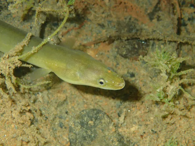 European eelRegular local target1 placeThe Roe estuaryOver estuary
Photo: jujurenoult, via Wikimedia Commons, CC BY 4.0; resized
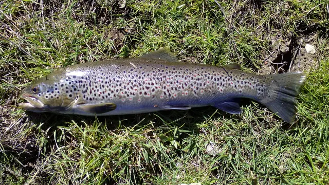 Brown troutRecorded here1 placeThe Roe estuaryOver estuary
Photo: Robermix, via Wikimedia Commons, CC0; resized and trimmed to fit
 European sea bassRecorded here1 placeThe Roe estuaryOver estuary
Photo: Julien Renoult, via Wikimedia Commons, CC BY 4.0; resized and trimmed to fit
 Thick-lipped grey mulletRecorded here1 placeThe Roe estuaryOver estuary
Photo: Diego Delso, via Wikimedia Commons, CC BY-SA 4.0; resized and trimmed to fit


,_Catania,_Sicilia,_Italia,_2025-04-04,_DD_63.jpg)
What these strengths mean
- Characteristic of this water
- This water is strongly identified with this species by the sources that cover it.
- Regular local target
- Fishing sources describe this as a normal local target here, not merely as caught.
- Recorded here
- At least one credible public account of this species being caught here. That is all it means.
- How breadth is counted
- A fish documented at six marks is shown as six marks: breadth never raises the strength on its own. A fishery account describes the fishing; a recorded catch reports one specific catch. How evidence is weighed.
How people fish here
2 methods are recorded on the places documented here, counted from those places themselves rather than from what is practised in the country. Each opens a full guide to the technique.
Dry fly fishing
Recorded at 1 place here, over river reach.
Presenting a floating artificial to a fish feeding at the surface, so that it drifts exactly as a natural insect would.
Ledgering
Recorded at 1 place here, over estuary.
Fishing a bait on the bottom held by a weight, with no float — the simplest way to fish at distance, in depth, or in wind.
Documented on the same ground: European flounder, European eel, Brown trout, European sea bass, Thick-lipped grey mullet.
These are the methods documented at the places FishingHQ holds here. A species listed beside a method is documented on the same ground, which is not the same as being taken that way — where a source establishes the method a fish was caught on, it is stated on that place’s own page. All fishing methods.
Baits and lures for these fish
The methods, baits and lures each of the fish above is commonly taken on, from that fish’s own page. This is what works for the fish, not a report of what people use on this particular water — local knowledge and the conditions on the day still decide.
Methods
- Float fishing — for European sea bass, Thick-lipped grey mullet
- Saltwater fly fishing — for European sea bass, Thick-lipped grey mullet
- Spinning — for European flounder, European sea bass
- Surfcasting — for European flounder, European sea bass
- Float-tube fishing — for Brown trout
- Popping and stickbaiting — for European sea bass
- Salmon fly fishing — for Brown trout
- Tenkara — for Brown trout
Baits
- Peeler crab — for European flounder, European sea bass
- Ragworm — for European flounder, European sea bass
- Bread — for Thick-lipped grey mullet
- Crab and shellfish — for European sea bass
- Fish strip and cut bait — for Thick-lipped grey mullet
- Sand eel — for European sea bass
Lures
- Streamers — for Brown trout, European sea bass
- Dry flies — for Brown trout
- Jerkbaits — for European sea bass
- Metal jigs — for European sea bass
- Nymphs — for Brown trout
- Soft plastics — for European sea bass
- Surface lures — for European sea bass
- Terrestrial fly patterns — for Brown trout
Also: Wet flies
What dominates
Shore fishing over the intertidal flats and around the entrance for flounder, mullet and bass. Estuary fishing on the Roe and the lower reaches for flounder, mullet and sea trout. Game angling for salmon and sea trout on the Mourne, the Strule, the Finn and the Derg, which is the fishery the system is best known for and which is heavily structured by season and by permit. Small-boat fishing in the lough and around the entrance.
The water available
A large shallow sea lough with extensive intertidal mud and sand flats and a narrow dredged channel. A constricted entrance at Magilligan with a strong tidal run and a sand spit. Several river estuaries entering it, the Roe across a wide sand flat from the east. Above the lough, a substantial river system running well inland through both jurisdictions, with classic salmon reaches around the confluences at Strabane.
How the rules are structured
THE FOYLE SYSTEM IS ADMINISTERED BY A CROSS-BORDER BODY and this is the fact that distinguishes it. The Loughs Agency, established under the British-Irish Agreement, administers fishing across the whole Foyle catchment on both sides of the border, and its licensing and permit arrangements are its own — different from the rest of Northern Ireland and from the rest of the Republic. Migratory salmon and sea trout carry their own licensing, seasons and conservation measures within that. Sea fisheries measures in the lough itself and its approaches involve both the agency and the departments on either side. Extensive habitat designation covers the lough and its flats. FishingHQ does not state what any current rule is: measures, designations and local byelaws change, and the answer differs by species and by stretch of coast.
Who to ask
- The Loughs Agency, the cross-border body that administers fishing throughout the Foyle catchment on both sides of the border, and whose licensing differs from that of either jurisdiction.
- The Northern Ireland department responsible for agriculture, environment and rural affairs, for sea fisheries measures and marine conservation on the northern shore.
- The Irish state fisheries and marine authorities, for the parts of the catchment inside the Republic.
- The Northern Ireland Environment Agency and the site management bodies, where habitat designation on the lough or its flats affects access or collection.
- The riparian owner or angling club holding the rights on any given river beat.
Words you will meet
- The Loughs Agency
- The cross-border body administering fishing in the Foyle and Carlingford catchments, established under the British-Irish Agreement. Its licences are not the same as either jurisdiction's, and an angler licensed elsewhere on the island is not licensed here by that fact.
- Sea lough
- A drowned tidal inlet of salt water. Used on this island for both these and for freshwater lakes, so the name alone does not tell you which.
Conditions and hazards
The intertidal flats are the distinctive hazard. Lough Foyle has very large areas of soft mud and sand that dry at low water and flood quickly, and the combination of soft ground and a fast flood is what catches people out: the route back becomes impassable while the ground being stood on is still dry.
The entrance at Magilligan carries a hard tidal run over a shifting sand spit and is dangerous water for small craft.
Cold water applies year-round. On the river system, the ordinary hazards of wading fast water apply, and the Mourne and Strule can rise quickly after rain in the catchment above.
Some of what lives here
Fish recorded here that FishingHQ holds a reviewed photograph of. It is not a complete list of what Lough Foyle and its rivers holds, and it is not a prediction that you will catch any of them — it is a way in to the ones we can show you.
- European flounderThe flatfish that runs up rivers — a tolerant, estuarine right-eyed flounder with bony tubercles along its fin bases and a habit of turning up in fresh water.
Photo: nbasargin, via iNaturalist, CC BY; resized and trimmed to fit
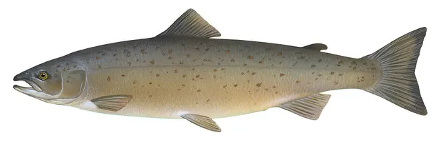 Atlantic salmonAn anadromous salmonid that migrates from its natal river to the North Atlantic and returns to spawn — and a species in serious, well-documented decline.
Illustration: Knepp, Timothy, via Wikimedia Commons, public domain; resized and trimmed to fit

Places within this area
Publicly documented fishing geography. FishingHQ describes what the ground is; it does not say whether you may fish it, and every one of these sends that question to the body that holds the answer. Browse every place in this part of the world.
Who to ask before fishing any of these
FishingHQ does not know the current access position here. Sea angling access in Northern Ireland is governed by landowner permission, harbour and council byelaws, and fisheries and conservation measures, all of which change. Check the current position with the Department of Agriculture, Environment and Rural Affairs, the harbour or council, and the landowner before going. This water is tidal and transitional, so the freshwater regime may also apply above the tidal limit: FishingHQ does not know the current access position here. Angling in Northern Ireland generally requires both a rod licence from the relevant fisheries body and a separate permit for the water, and the two are issued by different bodies. Rules, seasons and permit arrangements change. Check with the Department of Agriculture, Environment and Rural Affairs, the Loughs Agency where relevant, and the permit issuer before going.
The Foyle at Strabane
River reach · Tidal water, salinity not established
Where the Mourne and Finn meet to form the Foyle above a long tidal lough, carrying one of the largest salmon runs in Ireland through a cross-border catchment.
Severe hazards of Lough Foyle and its rivers apply here: tides and being cut off, cold water shock, drowning and immersion.
The Roe estuary
Estuary · Brackish water
The mouth of the River Roe where it enters the south-eastern corner of Lough Foyle, six kilometres north of Limavady: salt marsh and wide mud and sand flats exposed at low water, fished from a wall and the large boulders on its seaward side. The mud holds lugworm, ragworm, shrimp and periwinkle in quantity, and it holds shore crab in quantity too.
Wholly sheltered. Lough Foyle takes the weather off this water and the estuary itself is a soft-ground fishery rather than an exposed one.
Particular to this ground: tides and being cut off, cold water shock.
Severe hazards of Lough Foyle and its rivers apply here: drowning and immersion.
Particular to this water: This ground carries conservation designations that constrain access, vehicles, bait collection and disturbance independently of any fishing rule.
Safety
Tides and being cut off — Can cause serious injury or death
Ledges, sandbanks and beach sections reached at low water and cut off by a flooding tide that comes in behind rather than towards. The route back disappears before the standing ground does, which is why people are caught out on ground that is still dry.
What reduces it: Work out the time of the tide before going, not after arriving. Identify the point at which the way back closes and set an alarm for it. Never rely on being able to wade a channel that was walkable an hour earlier.
Worse when:
- Big spring tides, which flood faster and reach further
- Onshore wind and low pressure, which raise the water above the predicted height
- Fog or darkness, which remove the visual cues people navigate back by
Cold water shock — Can cause serious injury or death
Sea temperatures around these coasts stay low enough for most of the year that sudden immersion causes involuntary gasping and rapid loss of useful movement in the hands and arms. Swimming ability makes very little difference to the outcome in the first minute, which is the minute that decides it.
What reduces it: Wear a buoyancy aid on any rock, pier or harbour mark, not only on a boat. If you go in, float on your back and let the gasping pass before trying to do anything. Get out and get warm quickly — the danger continues after the water.
Worse when:
- Spring and early summer, when the air feels warm and the sea has not caught up
- Fishing alone, where nobody raises the alarm
- Heavy clothing and waders, which make self-rescue much harder
Drowning and immersion — Can cause serious injury or death
Soft intertidal mud over large areas of the lough, which a person can sink into far enough to be held, on ground that floods quickly. Being stuck in soft ground on a flooding tide is a specific and well-documented way of drowning without ever having been out of your depth.
What reduces it: Do not walk out over soft intertidal ground on a flooding tide. Test the ground and keep to firmer sand. Carry a means of calling for help and do not go alone. If stuck, spread your weight, do not struggle, and call for help immediately rather than after trying to free yourself.
Worse when:
- A big spring tide, which floods the flats faster and further
- After heavy rain, when the freshwater input softens the ground further
- Fog or falling light, when the way back is hard to find
Precautions that always apply here
- Check the tide before you go and know your exit route. Being cut off is the commonest way a shore session becomes a rescue.
- Tell somebody where you are going and when you expect to be back.
- Carry a charged phone in a waterproof case, or another means of calling for help.
- Do not wade alone. Judge depth and flow from the bank first, and turn back sooner than feels necessary.
Check the rules before you fish
Fishing laws, bylaws, access rules, seasons, bait restrictions and permitted methods vary by location and can change. Check the current rules from the relevant authority and the water you intend to fish before fishing.
Check with:
- Current national or regional law for where you are fishing
- Current local bylaws
- The relevant fisheries authority
- The landowner, club or fishery whose water it is
- Any restrictions specific to the species or the method you intend to use
Where to go next
What swims here
- Atlantic salmonThe Foyle carries one of the more significant migratory runs on the island, through the lough and up the Mourne, Strule, Finn and Derg. It is also why the catchment is licensed by a cross-border agency rather than by either jurisdiction.
- European flounderA large shallow sea lough with extensive intertidal mud and sand flats, and river estuaries entering across them. Flounder are what that ground holds, on both the Roe side and the main lough.
More fishing regions
Not related to this page — just the rest of the section. There is little else joined to this subject yet, and a short page should still lead somewhere.
Sources and evidence
- General angling website restatements of established technique — Various (Credible secondary source)Relied on for: Widely restated descriptions of the Foyle system, its marks and the species reported from them, recorded as consensus rather than as scholarship.Background and mechanism onlyCitation checked — the work exists and is described correctly
Why the 2 connections on this page are here, and the sources
What swims here
Backed by research — 2 connections
Supported by peer-reviewed research or fisheries science. The sources are listed and can be checked.
Atlantic salmon
A claim that a coast or region contains the ground and conditions this species is associated with. It is a distributional statement about the world, it rests on the reference literature and on the institute that surveyed it, and it deliberately asserts nothing about access, permission or catch.
- The Fishes of the British Isles and North-West Europe — Macmillan, 1969 (Reference work)Relied on for: Distribution and habitat association of the marine fishes of the British Isles and north-west Europe, including which coasts and ground types a species occupies.States this directlyCitation checked — the work exists and is described correctly
- FishBase: a global information system on fishes — Froese, R. and D. Pauly, eds. — FishBase Consortium (Scientific institute)Relied on for: Recorded distribution, depth range and habitat association for the species named.States this directlyPassage read and verified
European flounder
A claim that a coast or region contains the ground and conditions this species is associated with. It is a distributional statement about the world, it rests on the reference literature and on the institute that surveyed it, and it deliberately asserts nothing about access, permission or catch.
- The Fishes of the British Isles and North-West Europe — Macmillan, 1969 (Reference work)Relied on for: Distribution and habitat association of the marine fishes of the British Isles and north-west Europe, including which coasts and ground types a species occupies.States this directlyCitation checked — the work exists and is described correctly
- FishBase: a global information system on fishes — Froese, R. and D. Pauly, eds. — FishBase Consortium (Scientific institute)Relied on for: Recorded distribution, depth range and habitat association for the species named.States this directlyPassage read and verified
How FishingHQ labels evidence is explained in the evidence policy.