Malta and Gozo
Fishing regions · Last reviewed 2026-08-17
A small, intensely visited limestone archipelago in the middle of the Mediterranean, where everything is reachable on foot or by bus, the diving sector is enormous relative to the size of the place, and the local fishing culture is far older than the tourism.
Safety: cliffs and rock platforms — can cause serious injury or death. 3 more points apply here.
Shallow water blackout and breath-hold loss of consciousness — Can cause serious injury or death
Exceptional visibility makes depth look and feel considerably less than it is, which is a known and specific trap: divers go deeper than planned because the bottom appears close, and blackout concentrates in the final metres of the ascent.
What reduces it: Recognised freediving training. A competent buddy watching every dive, one up and one down. Never dive alone. Set a depth and time before entering the water and hold to them regardless of how shallow it looks. Aborting a dive is always a valid answer.
Worse when:
- Exceptionally clear water, which is most of the season here
- Diving after a long drive or a flight, tired
- Any hyperventilation before a dive
Being listed here is not permission to fish. What that meansClose
Access, fishing rights, seasons, licences, local bylaws and permitted methods vary and can change. Check current access, permission, local regulations, closures and restrictions before you travel or fish. FishingHQ describes what the ground is and names who holds the answer; it does not hold the answer itself.
Find the authority for a jurisdiction · What FishingHQ does and does not cover
Malta ranked thirteenth on FishingHQ's destination model and was built ahead of most of the places above it, deliberately and using the model's own printed limitation.
WHY THE RANKING UNDERSTATES IT. Catalogue weakness in the model is measured at world-region granularity, which is the finest resolution the region field offers. Six Mediterranean candidates therefore share one multiplier, and Malta — which scores 0.827 on the authored signals, above Sri Lanka and Cuba — is pushed down by how well the Mediterranean as a whole is covered. The destination report prints that caveat on every run. Building Malta is using the model rather than overriding it.
AND THE AUTHORED SIGNALS ARE WHY. Very high visitor volume from northern Europe. Everything reachable without a car on an island twenty-seven kilometres long. A diving and freediving sector out of all proportion to the size of the place. A local shore and small-boat fishing culture that is centuries old. And almost nothing written in English about how a visitor might fish there.
THE PHYSICAL SETUP. Limestone: cliffs, ledges, shelving rock platforms, small sandy bays and deep clear water close in. There are no rivers, no estuaries and no natural fresh water of any consequence. The shelf is narrow and drops away, so deep water is a short distance offshore.
AND THE WATER IS CLEAR AND POOR. The Mediterranean is oligotrophic and the water around Malta is exceptionally clear, which is beautiful, is why the diving is what it is, and means the fish see everything. Light lines and refined presentation matter here in a way they do not on a turbid Atlantic coast.
What fishing here is like
A small limestone archipelago in the central Mediterranean, made of cliff, ledge, rock platform and small sandy bay, with clear, deep, nutrient-poor water and no fresh water to speak of.
The fishing is shore-dominated by geography: deep water close in means a rock mark reaches ground that would need a boat on a shelving coast, and the island is small enough that most of the coastline is accessible. The small-boat and charter sector runs offshore for pelagics.
The diving sector is very large — Malta and Gozo are among the most visited diving destinations in the Mediterranean, with a long season, reliable visibility and a great deal of shore-accessible diving — and it brings a substantial freediving and spearfishing population with it.
The local fishing culture is old, distinct and visible: the traditional luzzu boats, the lampuki season that organises the autumn, and a shore-fishing tradition that has been practised from the same rocks for a very long time. A visitor fishing here is joining something rather than arriving at a resource.
What you can target here
One entry per fish, grouped by how you would be fishing — because the answer is a different one from the rocks and from a boat. Each entry says how strongly the sources support it and how much evidence sits behind it. These are documented catches, not a forecast, and none of it is a statement that you may fish any particular ground.
From the shore · 4
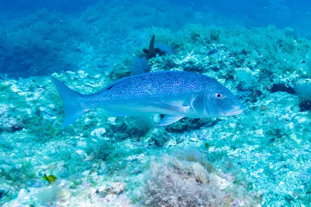
From a boat · 2
What these strengths mean
- Regular local target
- Fishing sources describe this as a normal local target here, not merely as caught.
- Seasonal
- Well supported, and concentrated in part of the year rather than spread through it.
- Repeatedly reported
- Several independent public accounts. Enough to say it happens more than once; not enough to call it a fishery.
- How breadth is counted
- A fish documented at six marks is shown as six marks: breadth never raises the strength on its own. A fishery account describes the fishing; a recorded catch reports one specific catch. How evidence is weighed.
How people fish here
3 methods are recorded on the places documented here, counted from the records themselves rather than from what is practised in the country. Each opens a full guide to the technique.
Float fishing
Recorded at 2 places here, over headland, rock mark.
Suspending a bait at a controlled depth beneath a buoyant indicator — the most visual, most controllable and most widely applicable method in angling.
Documented on the same ground: Greater amberjack, White seabream, Common dentex, Common octopus.
Shore diving
Recorded at 2 places here, over headland, rock mark.
Entering and leaving the water from land under your own power — the most accessible spearfishing and the one where the entry and exit are the dangerous part.
Documented on the same ground: Greater amberjack, White seabream, Common dentex, Common octopus.
Spinning
Recorded at 1 place here, over headland.
Casting an artificial lure and retrieving it so that it moves like something alive — the most direct form of lure fishing.
Documented on the same ground: Greater amberjack, White seabream, Common dentex, Common octopus.
These are the methods documented at the places FishingHQ holds here. A species listed beside a method is documented on the same ground, which is not the same as being taken that way — where a source establishes the method a fish was caught on, it is stated on that place’s own page. All fishing methods.
What dominates
Shore fishing from rock ledges and platforms, which is the dominant local practice: float fishing and light bottom fishing for bream, wrasse, mullet and picarel, and spinning and light lure fishing for barracuda, amberjack, bluefish and bonito where deep water is close.
Spearfishing and freediving, which are practised extensively and are culturally established here rather than imported. The ground — clear water, structure, deep edges close in — suits it exceptionally.
Boat fishing offshore for lampuki in the autumn, which is the island's characteristic seasonal fishery, and for tuna, amberjack and other pelagics through the year.
Squid and cuttlefish fishing from shore and boat, which is a mainstream local activity and one a visitor can do with a small amount of gear.
There is no freshwater fishing of any kind.
The water available
Limestone cliff, ledge and shelving rock platform around most of the coast, with small sandy bays and a few larger beaches. Deep clear water close inshore, with a narrow shelf and a fairly quick drop offshore.
Posidonia seagrass meadows on the sand between rock, which are the nursery habitat of this coast and are protected — and which is the anchoring restriction a visiting boat angler is most likely to meet in person.
Offshore, open Mediterranean with seamounts and banks within reach of a boat, and the pelagic community that goes with them.
No rivers, no estuaries, no salinity gradient and no freshwater environment of any kind on the islands.
How the rules are structured
Maltese national law within the European Union framework, administered through the national fisheries and aquaculture department, with marine protected areas and Natura 2000 sites covering substantial areas of coastal water.
The structural points that matter to a visitor: recreational sea fishing, spearfishing and the taking of specific species are separately regulated; spearfishing in particular carries restrictions on equipment, areas and — importantly for visitors — on who may practise it and with what registration; several species carry size limits and some carry closed periods; and Posidonia seagrass is protected, with consequences for anchoring.
Spearfishing rules across the Mediterranean differ sharply between neighbouring countries, and a diver arriving from Italy, Spain or Croatia should assume nothing carries over.
NOTHING ON THIS PAGE IS A CURRENT RULE. Licensing, permitted methods, marine park boundaries, spearfishing restrictions, size limits and what may be taken all differ here from what a visitor will assume, differ between areas, and are revised. Establish the position with the authorities named on this page before fishing, and do it before travelling rather than on arrival. FishingHQ does not state what any current rule is.
Who to ask
- The Maltese Department of Fisheries and Aquaculture, for the recreational fishing framework, licensing and species rules
- The Environment and Resources Authority, for marine protected areas, Natura 2000 sites and protected habitat including Posidonia
- Transport Malta, for anything involving a vessel, and for the maritime rules that apply to a hired boat
- A local dive centre or spearfishing club, which is the fastest practical route to the current position on spearfishing and to what is expected of a visitor
- The tackle shops, which in Malta are a genuine source of local practice and current rules and are used as such by residents
Words you will meet
- Lampuki
- The dolphinfish or mahi-mahi, Coryphaena hippurus, and the fish the Maltese fishing year is organised around. The autumn lampuki fishery, worked with floating palm-frond rafts that attract the fish, is the island's characteristic seasonal fishery.
- Luzzu
- The traditional Maltese fishing boat, brightly painted with an eye on the bow, still working and not merely decorative.
- Kannizzati
- The floating rafts of palm fronds set offshore to attract lampuki, which are the physical basis of the autumn fishery and are placed under a licensed system.
- Xatba
- A rock ledge or shelf at the waterline — the kind of platform most Maltese shore fishing is done from, and the ground the safety notes on this page are about.
- Vopi and cerna
- Local names appearing constantly in Maltese fishing conversation — vopi for the bogue, a small shoaling bream, and cerna for the dusky grouper, which is the prize of the local spearfishing tradition.
Conditions and hazards
ROCK PLATFORMS ARE THE HAZARD HERE, and they are the reason this coast needs a safety section at all. Maltese shore fishing is done from limestone ledges at the waterline, frequently below cliffs, frequently with deep water immediately in front. Swell arrives in sets and the largest wave of a set is several times the height of the ones before it; wet limestone with algae on it is genuinely slippery; and a person in the water at the base of a cliff has nowhere to get out. Access to many ledges involves a climb.
THE SEA LOOKS SAFER THAN IT IS. Clear, warm, calm-looking water below a cliff is still deep water with no exit, and the absence of tide removes a warning signal that anglers from Atlantic coasts rely on.
HEAT is severe in summer, and shade on a rock ledge does not exist.
FOR DIVERS AND SPEARFISHERS the specific risks are boat traffic — this is a busy, small, intensively used sea area — and the temptation of exceptional visibility, which makes depth look and feel less than it is. Clear water is the classic condition for a diver going deeper than planned.
AND WEEVER AND SCORPIONFISH are present on sandy and rocky bottom respectively, as they are throughout the Mediterranean, and both are handled by people who did not expect them.
Everything is reachable, which is the whole argument for the place
Malta's fishing case rests less on what is there than on how easy it is to get to, and that is a legitimate basis for a destination record.
THE ISLAND IS TWENTY-SEVEN KILOMETRES LONG. Gozo is smaller. A bus network covers both, and no part of the coast is more than a short journey from anywhere else. A visitor without a car, without a boat and without a guide can reach rock marks, bays, harbours and dive sites on foot and by public transport, which is not true of most Mediterranean destinations and is emphatically not true of the tropical ones.
DEEP WATER IS CLOSE. Limestone cliff and ledge coast with a narrow shelf means that a shore angler standing on a rock platform is fishing water that would require a boat on a shelving coast. That is why the shore fishing here reaches species — amberjack, barracuda, bonito, bluefish — that are a boat proposition elsewhere.
AND THE DIVING IS SHORE-ACCESSIBLE TOO, which is unusual and is a large part of why the sector is the size it is. A person can walk into the water and be over interesting ground within minutes, which lowers the cost of everything and makes a week's trip productive rather than logistical.
WHAT A VISITOR CAN ACTUALLY DO. Light shore fishing with a travel rod for bream, wrasse, mullet and picarel from almost any rock. Squid jigging from harbour walls and rock in the cooler months. Spinning for pelagics from deep-water marks. Snorkelling and freediving almost anywhere. A boat trip offshore for the pelagic fishery. And in autumn, the lampuki season, which is the thing the island's fishing year is actually organised around.
WHAT THIS PAGE WILL NOT DO is name a mark. FishingHQ does not do that anywhere and Malta is a particularly bad place to start: the good ledges are known, the access to several of them is a scramble, and a recommendation from a page to somebody who has not seen the swell is exactly the mechanism this product exists to avoid.
What experienced anglers do — why, and the sources (2)
Widely and independently recommended by experienced anglers and specialist sources. This is real angling knowledge, not proof: controlled evidence for it is limited, and FishingHQ records it as convention rather than as a demonstrated effect.
- General angling website restatements of established technique — Various (Credible secondary source)Relied on for: Widely restated descriptions of regional practice, ground and species, recorded as consensus rather than as scholarship.Background and mechanism onlyCitation checked — the work exists and is described correctly
- FAO Species Identification Guides for Fishery Purposes and the FAO Species Catalogues — Food and Agriculture Organization of the United Nations (Scientific institute)Relied on for: Species composition, habitat association and distribution for the region concerned, as set out in the FAO species identification sheets.States this directlyCitation checked — the work exists and is described correctly
Spearfishing here, and why a diver from the next country should assume nothing
Malta has an established spearfishing culture and a large visiting diving population, and the interaction between those two is where a visitor is most likely to get something seriously wrong.
THE GROUND IS EXCELLENT AND THAT IS THE PROBLEM. Clear water, structure, deep edges within swimming distance of shore, and a long season. It is close to ideal, and it makes a visiting spearfisher want to get in the water before establishing anything.
MEDITERRANEAN SPEARFISHING LAW DIFFERS SHARPLY BETWEEN NEIGHBOURS. Equipment restrictions, permitted areas, registration or licensing requirements, species rules, minimum distances from other water users, and whether a visitor may practise at all are all national questions with different answers in Malta, Italy, Spain, France, Croatia and Greece. Nothing carries over, and the assumption that it does is the commonest visitor error in this discipline anywhere.
THE PROTECTED AREAS ARE REAL. Marine protected areas and Natura 2000 sites cover substantial coastal water here, and what is permitted inside one differs from outside it.
AND THE DUSKY GROUPER IS THE LOCAL PRIZE, which makes it the local problem. It is the most valued catch in Mediterranean spearfishing, it is assessed as Vulnerable, it is a protogynous hermaphrodite so the large individuals are males, and it is territorial and curious — meaning size-selective removal takes the males out of a population that cannot replace them quickly. Whatever any rule says, a visitor taking large grouper from a small, intensively dived archipelago is doing something with a cost.
THE SAFETY POSTURE IS UNCHANGED FROM THE REST OF FISHINGHQ. Recognised freediving and spearfishing training. A competent buddy who is watching, one up and one down. Never diving alone. Conservative judgement, and clear water making depth feel less than it is is a known and specific trap. Boat traffic is heavy in a small sea area, so a marked float is not optional. And aborting a dive is always a valid answer.
NOTHING ON THIS PAGE IS A CURRENT RULE. Licensing, permitted methods, marine park boundaries, spearfishing restrictions, size limits and what may be taken all differ here from what a visitor will assume, differ between areas, and are revised. Establish the position with the authorities named on this page before fishing, and do it before travelling rather than on arrival. FishingHQ does not state what any current rule is.
Official guidance — why, and the sources (4)
Stated by a fisheries authority, scientific institute or recognised angling body. Authoritative, but summarising rather than demonstrating.
- CMAS technical and sporting standards for underwater activities — Confédération Mondiale des Activités Subaquatiques (Standards body)Relied on for: Breath-hold diving and spearfishing practice, training structure and the safety expectations set out by the international underwater federation.States this directlyCitation checked — the work exists and is described correctly
- DAN guidance on freediving safety, hypoxia and shallow-water blackout — Divers Alert Network (Water-safety or diver-training authority)Relied on for: Freediving safety guidance including the buddy system, blackout, and the management of diving in warm and in unfamiliar water.States this directlyPassage read and verified
- Reef Fish Spawning Aggregations: Biology, Research and Management — Springer, Fish & Fisheries Series vol. 35, 2012 (Scientific literature)Relied on for: The biology and exploitation of reef fish spawning aggregations and their vulnerability to size-selective fishing.States this directlyCitation checked — the work exists and is described correctly
- The IUCN Red List of Threatened Species — International Union for Conservation of Nature (Conservation authority)Relied on for: Global assessments and distribution for the species and habitats concerned, including reef-associated and migratory species.States this directlyCitation checked — the work exists and is described correctly
Lampuki, kannizzati and a fishing year that belongs to somebody
The most interesting thing about Maltese fishing is not a species or a technique. It is that the year has a shape, and the shape is old.
THE LAMPUKI SEASON IS THE AXIS. From late summer into autumn, dolphinfish move through the central Mediterranean, and the Maltese fishery for them is worked with kannizzati — floating rafts of palm fronds set offshore, under which the fish gather because dolphinfish associate with any floating object. Boats work a licensed system of raft positions, and the fish come ashore in quantity for a few months and then stop.
IT IS A FOOD FISHERY AND A CULTURAL EVENT rather than a sport one. Lampuki appears on every menu in season and disappears out of it; the fishery is regulated and the raft positions are allocated; and the season organises the working year of a substantial part of the small-boat fleet.
WHY THIS MATTERS TO A VISITING ANGLER. It is a reminder that the water here is not an unused resource. Maltese shore marks have been fished from for centuries, the rock ledges have names, and the small-boat fleet is a working one rather than a heritage display. A visitor is a guest in an active fishery, which is a different thing from arriving at an under-fished coast — and it is the honest framing for a destination this small and this intensively used.
THE OTHER SEASONAL PATTERNS. Squid and cuttlefish come inshore in the cooler months and are fished from harbour walls and rock. Bream and wrasse are available year-round from the shore. Bluefish, bonito and amberjack are warm-season pelagic visitors to deep-water shore marks. And the diving season runs far longer than a northern European expects, with water still comfortable well into autumn.
AND THE HISTORY IS VISIBLE. The luzzu, painted with an eye on the bow in a tradition that long predates the current state, is still a working boat. It is one of very few places in Europe where the traditional inshore craft is genuinely in use rather than preserved.
What experienced anglers do — why, and the sources (3)
Widely and independently recommended by experienced anglers and specialist sources. This is real angling knowledge, not proof: controlled evidence for it is limited, and FishingHQ records it as convention rather than as a demonstrated effect.
- General angling website restatements of established technique — Various (Credible secondary source)Relied on for: Widely restated descriptions of regional practice, ground and species, recorded as consensus rather than as scholarship.Background and mechanism onlyCitation checked — the work exists and is described correctly
- FAO Species Identification Guides for Fishery Purposes and the FAO Species Catalogues — Food and Agriculture Organization of the United Nations (Scientific institute)Relied on for: Species composition, habitat association and distribution for the region concerned, as set out in the FAO species identification sheets.States this directlyCitation checked — the work exists and is described correctly
- Code of Conduct for Responsible Fisheries — Food and Agriculture Organization of the United Nations, Rome, 1995 (Standards body)Relied on for: International principles for responsible fisheries, including the management of small-scale and artisanal fisheries and the protection of critical habitat.Background and mechanism onlyCitation checked — the work exists and is described correctly
Some of what lives here
Fish recorded here that FishingHQ holds a reviewed photograph of. It is not a complete list of what Malta and Gozo holds, and it is not a prediction that you will catch any of them — it is a way in to the ones we can show you.
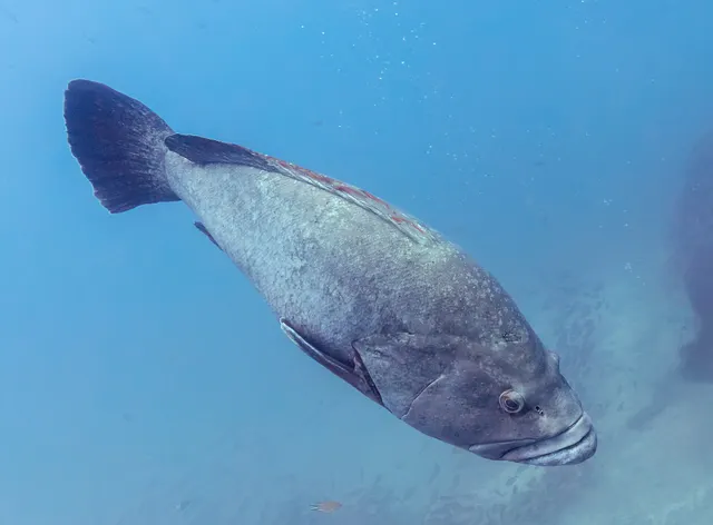 Dusky grouperThe Mediterranean's iconic reef predator: territorial, slow to mature, sex-changing, and the species whose decline made the case for marine protected areas there.
Diego Delso — CC BY-SA 4.0, via Wikimedia Commons
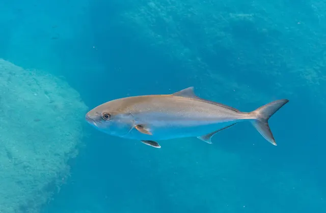 Greater amberjackThe largest amberjack — a circumglobal reef and wreck predator that fights downward with more raw power per kilogram than almost anything, and carries a genuine ciguatera caveat.
Diego Delso — CC BY-SA 4.0, via Wikimedia Commons
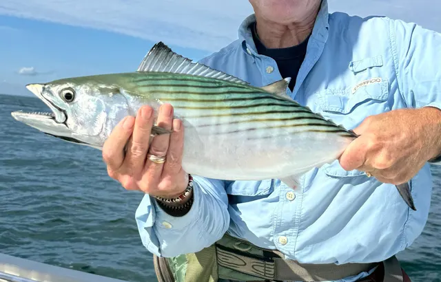 Atlantic bonitoA small, fast, striped tuna relative that arrives on temperate coasts in shoals each year and is the most accessible member of the family to a shore angler.
ricofish — CC0, via Wikimedia Commons
Places within this area
Publicly documented fishing geography. FishingHQ describes what the ground is; it does not say whether you may fish it, and every one of these sends that question to the body that holds the answer. Browse every place in this part of the world.
Who to ask before fishing any of these
FishingHQ does not know the current access position here. Malta licenses recreational boat fishing and underwater fishing separately, underwater fishing carries its own age, equipment and area rules, and the islands' marine protected areas and bunkering zones constrain where anything may happen. Species measures — bluefin tuna above all — are managed internationally and change every season. Check the current position with the department responsible for fisheries and aquaculture before going.
Dwejra, Gozo
Rock mark · Salt water
A limestone coast on the western side of Gozo with a collapsed cave forming a small enclosed lagoon connected to the sea by a tunnel through the cliff, boulder and rock shelf at the water's edge and deep clear water beyond.
Takes weather from the west and north-west directly, and is unusable in any swell from those directions.
Particular to this ground: drowning and immersion, sun, dehydration and fatigue.
Severe hazards of Malta and Gozo apply here: cliffs and rock platforms, boat traffic and being seen, shallow water blackout and breath-hold loss of consciousness.
Particular to this water: This ground lies in or beside a marine protected area whose zoning constrains fishing, diving, anchoring and collection independently of any licence, with rules that differ between zones and boundaries that are not visible from the water. Underwater fishing is licensed and regulated separately from rod fishing throughout this jurisdiction, with its own age, equipment and distance requirements, and holding a rod licence is not permission to spearfish.
Delimara Point
Headland · Salt water
A low limestone peninsula on the south-eastern corner of Malta, with wave-cut ledges at the water's edge, deep water immediately off the point and the traditional fishing harbour of Marsaxlokk in the bay behind it.
Exposed from east through south, and sheltered from the prevailing north-westerly by the island itself.
Particular to this ground: drowning and immersion, sun, dehydration and fatigue.
Severe hazards of Malta and Gozo apply here: cliffs and rock platforms, boat traffic and being seen, shallow water blackout and breath-hold loss of consciousness.
Particular to this water: Underwater fishing is licensed and regulated separately from rod fishing throughout this jurisdiction, with its own age, equipment and distance requirements, and holding a rod licence is not permission to spearfish.
Safety
Shallow water blackout and breath-hold loss of consciousness is set out at the top of this page, where it cannot be missed.
Cliffs and rock platforms — Can cause serious injury or death
Maltese shore fishing is done from limestone ledges at the waterline, frequently below cliffs and frequently with deep water immediately in front. Swell arrives in sets and the largest wave is several times the height of the preceding ones; wet algae-covered limestone is extremely slippery; access often involves a scramble; and a person in the water at the base of a cliff has no exit.
What reduces it: Watch a mark for a full set cycle — at least twenty minutes — before committing. Wear a buoyancy aid and footwear with grip. Know the exit before you start, and know that on many of these marks there is not one. Do not fish a ledge alone, and treat any forecast swell as a decision already made.
Worse when:
- Any ground swell, regardless of what the local wind is doing
- After dark, when a set is invisible
- Marks reached by a climb, where retreat is slow
Boat traffic and being seen — Can cause serious injury or death
This is a small, busy, intensively used sea area with heavy recreational and commercial traffic, and a snorkeller or freediver at the surface is close to invisible from a boat.
What reduces it: A marked surface float on every dive, without exception. Stay clear of channels and harbour approaches. Assume no vessel has seen you and that none is going to alter course.
Worse when:
- Summer, at the height of the season
- Near harbours, bays and popular anchorages
Sun, dehydration and fatigue — Can cause injury needing treatment
Mediterranean summer heat with no shade available on a rock platform, and a long walk or climb back at the end of a session.
What reduces it: Avoid the middle of the day in summer. Carry more water than seems necessary and physical cover. Plan the exit for when you will be tired rather than for when you arrived.
Worse when:
- Summer afternoons
- Marks reached by a long walk or a climb
Further safety reading
- Rock platform and cliff safety — Limestone ledges at the waterline below cliffs, with deep water in front, sets that arrive without warning and frequently no exit.
- Surface markers and boat traffic — A small, busy, intensively used sea area where a diver at the surface is close to invisible.
Check the rules before you fish
Fishing laws, bylaws, access rules, seasons, bait restrictions and permitted methods vary by location and can change. Check the current rules from the relevant authority and the water you intend to fish before fishing.
Check with:
- Current national or regional law for where you are fishing
- Current local bylaws
- The relevant fisheries authority
- The landowner, club or fishery whose water it is
- Any restrictions specific to the species or the method you intend to use
Where to go next
What swims here
- Atlantic bonitoA warm-season pelagic visitor to deep-water shore marks and to the small-boat fishery.
- Dusky grouperThe prize of the local spearfishing tradition, and — being protogynous, territorial and slow-growing — the species where the cost of taking the large ones is highest.
- European squidInshore in the cooler months, and jigged from harbour walls and rock as a mainstream local activity.
- Greater amberjackOver deep water close to shore, and one of the pelagic species the limestone drop-offs put within reach of a rock mark.
- Mediterranean morayIn the limestone crevices and ledges that make up most of this coast, which is exactly the ground hole hunting searches.
- Red scorpionfishMotionless on rock and rubble, and one of the two animals most likely to injure a diver who reaches somewhere without looking.
How this compares
- Balearic IslandsTwo intensively visited Mediterranean archipelagos with clear water, protected Posidonia and strong local spearfishing cultures — and different national rules governing all three of those things.
- CyprusTwo Mediterranean islands whose shore fishing is genuinely similar — small resident fish, fine tackle, no tide, clear nutrient-poor water, deep water close in on rock coasts — and whose administration is not. Malta is one jurisdiction; Cyprus is administered separately in different parts of the island, and a permission in one part is not a permission in the other. The fishing transfers and the paperwork does not.
- Rocky shores and reefsLimestone ledge and platform is the ground almost all Maltese shore fishing is done from, and the hazard model that goes with it.
- Seagrass bedsPosidonia meadows on the sand between the limestone, which are protected and which carry the anchoring restriction a visiting boat angler is most likely to meet in person.
- The Croatian AdriaticThe two Mediterranean destinations where a visiting spearfisher is most likely to assume the rules travel with them. They do not, and the difference between these two is the clearest illustration.
Rules and access
Sources and evidence
- FAO Species Identification Guides for Fishery Purposes and the FAO Species Catalogues — Food and Agriculture Organization of the United Nations (Scientific institute)Relied on for: Species composition, habitat association and distribution for the region concerned, as set out in the FAO species identification sheets.States this directlyCitation checked — the work exists and is described correctly
- CMAS technical and sporting standards for underwater activities — Confédération Mondiale des Activités Subaquatiques (Standards body)Relied on for: Breath-hold diving and spearfishing practice, training structure and the safety expectations set out by the international underwater federation.States this directlyCitation checked — the work exists and is described correctly
- The IUCN Red List of Threatened Species — International Union for Conservation of Nature (Conservation authority)Relied on for: Global assessments and distribution for the species and habitats concerned, including reef-associated and migratory species.States this directlyCitation checked — the work exists and is described correctly
- Code of Conduct for Responsible Fisheries — Food and Agriculture Organization of the United Nations, Rome, 1995 (Standards body)Relied on for: International principles for responsible fisheries, including the management of small-scale and artisanal fisheries and the protection of critical habitat.Background and mechanism onlyCitation checked — the work exists and is described correctly
- General angling website restatements of established technique — Various (Credible secondary source)Relied on for: Widely restated descriptions of regional practice, ground and species, recorded as consensus rather than as scholarship.Background and mechanism onlyCitation checked — the work exists and is described correctly
Why the 14 connections on this page are here, and the sources
What swims here
Backed by research — 6 connections
Supported by peer-reviewed research or fisheries science. The sources are listed and can be checked.
Atlantic bonito
A distributional claim about where a species occurs, resting on the regional identification literature rather than on angling report. It says nothing about where a reader should fish.
- FAO Species Identification Guides for Fishery Purposes and the FAO Species Catalogues — Food and Agriculture Organization of the United Nations (Scientific institute)Relied on for: Species composition, habitat association and distribution for the region concerned, as set out in the FAO species identification sheets.States this directlyCitation checked — the work exists and is described correctly
- The IUCN Red List of Threatened Species — International Union for Conservation of Nature (Conservation authority)Relied on for: Global assessment and distribution for the species concerned.States this directlyCitation checked — the work exists and is described correctly
Dusky grouper
A distributional claim about where a species occurs, resting on the regional identification literature rather than on angling report. It says nothing about where a reader should fish.
- FAO Species Identification Guides for Fishery Purposes and the FAO Species Catalogues — Food and Agriculture Organization of the United Nations (Scientific institute)Relied on for: Species composition, habitat association and distribution for the region concerned, as set out in the FAO species identification sheets.States this directlyCitation checked — the work exists and is described correctly
- The IUCN Red List of Threatened Species — International Union for Conservation of Nature (Conservation authority)Relied on for: Global assessment and distribution for the species concerned.States this directlyCitation checked — the work exists and is described correctly
European squid
A distributional claim about where a species occurs, resting on the regional identification literature rather than on angling report. It says nothing about where a reader should fish.
- FAO Species Identification Guides for Fishery Purposes and the FAO Species Catalogues — Food and Agriculture Organization of the United Nations (Scientific institute)Relied on for: Species composition, habitat association and distribution for the region concerned, as set out in the FAO species identification sheets.States this directlyCitation checked — the work exists and is described correctly
- The IUCN Red List of Threatened Species — International Union for Conservation of Nature (Conservation authority)Relied on for: Global assessment and distribution for the species concerned.States this directlyCitation checked — the work exists and is described correctly
Greater amberjack
A distributional claim about where a species occurs, resting on the regional identification literature rather than on angling report. It says nothing about where a reader should fish.
- FAO Species Identification Guides for Fishery Purposes and the FAO Species Catalogues — Food and Agriculture Organization of the United Nations (Scientific institute)Relied on for: Species composition, habitat association and distribution for the region concerned, as set out in the FAO species identification sheets.States this directlyCitation checked — the work exists and is described correctly
- The IUCN Red List of Threatened Species — International Union for Conservation of Nature (Conservation authority)Relied on for: Global assessment and distribution for the species concerned.States this directlyCitation checked — the work exists and is described correctly
Mediterranean moray
A distributional claim about where a species occurs, resting on the regional identification literature rather than on angling report. It says nothing about where a reader should fish.
- FAO Species Identification Guides for Fishery Purposes and the FAO Species Catalogues — Food and Agriculture Organization of the United Nations (Scientific institute)Relied on for: Species composition, habitat association and distribution for the region concerned, as set out in the FAO species identification sheets.States this directlyCitation checked — the work exists and is described correctly
- The IUCN Red List of Threatened Species — International Union for Conservation of Nature (Conservation authority)Relied on for: Global assessment and distribution for the species concerned.States this directlyCitation checked — the work exists and is described correctly
Red scorpionfish
A distributional claim about where a species occurs, resting on the regional identification literature rather than on angling report. It says nothing about where a reader should fish.
- FAO Species Identification Guides for Fishery Purposes and the FAO Species Catalogues — Food and Agriculture Organization of the United Nations (Scientific institute)Relied on for: Species composition, habitat association and distribution for the region concerned, as set out in the FAO species identification sheets.States this directlyCitation checked — the work exists and is described correctly
- The IUCN Red List of Threatened Species — International Union for Conservation of Nature (Conservation authority)Relied on for: Global assessment and distribution for the species concerned.States this directlyCitation checked — the work exists and is described correctly
How this compares
What experienced anglers do — 5 connections
Widely and independently recommended by experienced anglers and specialist sources. This is real angling knowledge, not proof: controlled evidence for it is limited, and FishingHQ records it as convention rather than as a demonstrated effect.
Balearic Islands
A comparison a traveller choosing between two destinations genuinely needs.
- General angling website restatements of established technique — Various (Credible secondary source)Relied on for: Widely restated descriptions of regional practice, ground and species, recorded as consensus rather than as scholarship.Background and mechanism onlyCitation checked — the work exists and is described correctly
- Code of Conduct for Responsible Fisheries — Food and Agriculture Organization of the United Nations, Rome, 1995 (Standards body)Relied on for: International principles for responsible fisheries, including the management of small-scale and artisanal fisheries.Background and mechanism onlyCitation checked — the work exists and is described correctly
Cyprus
A comparison written where a traveller will reach one record having read the other and would otherwise carry an assumption across that does not hold.
- The European Environment Agency's assessments of Europe's waters, seas and coasts — European Environment Agency, Copenhagen (Conservation authority)Relied on for: State-of-the-environment assessment of Europe's seas including the Mediterranean, nutrient status, and the coverage of marine protected sites.States this directlyCitation checked — the work exists and is described correctly
- EMODnet — the European Marine Observation and Data Network — The European Commission, assembled from the national hydrographic offices, geological surveys and marine institutes of the member states (Scientific institute)Relied on for: Bathymetry, salinity and physical oceanography of European and adjacent sea basins.States this directlyCitation checked — the work exists and is described correctly
Rocky shores and reefs
A destination joined to the ground it is made of, so a reader can follow from the place to how the habitat behaves.
- General angling website restatements of established technique — Various (Credible secondary source)Relied on for: Widely restated descriptions of regional practice, ground and species, recorded as consensus rather than as scholarship.Background and mechanism onlyCitation checked — the work exists and is described correctly
- Code of Conduct for Responsible Fisheries — Food and Agriculture Organization of the United Nations, Rome, 1995 (Standards body)Relied on for: International principles for responsible fisheries, including the management of small-scale and artisanal fisheries.Background and mechanism onlyCitation checked — the work exists and is described correctly
Seagrass beds
A destination joined to the ground it is made of, so a reader can follow from the place to how the habitat behaves.
- General angling website restatements of established technique — Various (Credible secondary source)Relied on for: Widely restated descriptions of regional practice, ground and species, recorded as consensus rather than as scholarship.Background and mechanism onlyCitation checked — the work exists and is described correctly
- Code of Conduct for Responsible Fisheries — Food and Agriculture Organization of the United Nations, Rome, 1995 (Standards body)Relied on for: International principles for responsible fisheries, including the management of small-scale and artisanal fisheries.Background and mechanism onlyCitation checked — the work exists and is described correctly
The Croatian Adriatic
A comparison a traveller choosing between two destinations genuinely needs.
- General angling website restatements of established technique — Various (Credible secondary source)Relied on for: Widely restated descriptions of regional practice, ground and species, recorded as consensus rather than as scholarship.Background and mechanism onlyCitation checked — the work exists and is described correctly
- Code of Conduct for Responsible Fisheries — Food and Agriculture Organization of the United Nations, Rome, 1995 (Standards body)Relied on for: International principles for responsible fisheries, including the management of small-scale and artisanal fisheries.Background and mechanism onlyCitation checked — the work exists and is described correctly
Safety reading
Official guidance — 2 connections
Stated by a fisheries authority, scientific institute or recognised angling body. Authoritative, but summarising rather than demonstrating.
Rock platform and cliff safety
A link to a safety topic substantial enough to be read in full.
- RNLI water safety guidance: cold water shock and Float to Live — Royal National Lifeboat Institution (Water-safety or diver-training authority)Relied on for: Water safety guidance for coastal users.States this directlyPassage read and verified
Surface markers and boat traffic
A link to a safety topic substantial enough to be read in full.
- RNLI water safety guidance: cold water shock and Float to Live — Royal National Lifeboat Institution (Water-safety or diver-training authority)Relied on for: Water safety guidance for coastal users.States this directlyPassage read and verified
Rules and access
Official guidance — 1 connection
Stated by a fisheries authority, scientific institute or recognised angling body. Authoritative, but summarising rather than demonstrating.
Method and bait restrictions
This points to the kind of rule that applies rather than to any rule itself, so the page carries the notice that the requirement varies.
- Code of Conduct for Responsible Fisheries — Food and Agriculture Organization of the United Nations, Rome, 1995 (Standards body)Relied on for: International principles for fisheries management, including the role of national authorities and the management of protected areas.Background and mechanism onlyCitation checked — the work exists and is described correctly
- Angling Trust guidance for anglers — Angling Trust (Angling or fisheries organisation)Relied on for: The structure of angling regulation and the framework within which anglers are asked to establish local rules.States this directlyCitation checked — the work exists and is described correctly
How FishingHQ labels evidence is explained in the evidence policy.