Saltcoats harbour
Harbour wall · Salt water · in The Firth of Clyde
A small drying harbour behind a rock shore on the Ayrshire coast, with the old harbour walls, the sea wall along the promenade and reef running out on both sides. The reef is the fishing; the harbour is where you stand.
Safety: cliffs and rock platforms — can cause serious injury or death. 2 more points apply here.
FishingHQ describes what this place is, not whether you may fish it. Access, permits and who to ask.
What you can catch here
Documented at this place, grouped by how you would be fishing, with how strongly the sources support each one. This is what has been written down, not a forecast, and being listed is never permission to fish.
From the shore · 7
 Ballan wrasseRegular local target1 placeSaltcoats harbourOver harbour wall
 PollackRegular local target1 placeSaltcoats harbourOver harbour wall
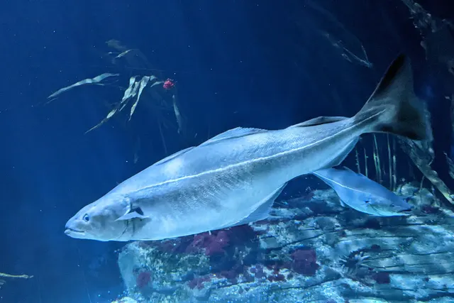 SaitheRegular local target1 placeSaltcoats harbourOver harbour wall
- Small-spotted catsharkRegular local target1 placeSaltcoats harbourOver harbour wall
 Atlantic codSeasonal1 placeSaltcoats harbourOver harbour wallAround Jan–Feb, Nov–Dec
- DabRecorded here1 placeSaltcoats harbourOver harbour wall
 European flounderRecorded here1 placeSaltcoats harbourOver harbour wall
What these strengths mean
- Regular local target
- Fishing sources describe this as a normal local target here, not merely as caught.
- Seasonal
- Well supported, and concentrated in part of the year rather than spread through it.
- Recorded here
- At least one credible public account of this species being caught here. That is all it means.
- How breadth is counted
- A fish documented at six marks is shown as six marks: breadth never raises the strength on its own. A fishery account describes the fishing; a recorded catch reports one specific catch. How evidence is weighed.
Fish documented nearby, not here
Nothing below has been documented at Saltcoats harbour itself. Each one has been documented at a named place on the same ground, and the places are listed with it. Treat this as what the water around here holds rather than as a catch list for this mark.
Widely documented on this ground
Documented at three or more neighbouring places, fished a way this place is also fished. That is a pattern about the ground rather than about any one mark, and it is the closest this site comes to saying you will probably meet a fish somewhere nothing has been written about.
From the shore
- Conger eel — documented at Loch Long; Ardrossan; Millport and Crocodile Rock
- Atlantic mackerel — documented at Loch Fyne; Largs and the Cumbrae channel; Troon and Ayr (+1 more)
Also documented at neighbouring places
One or two accounts each, on the ground around here. Enough to know the fish is caught in these waters; not enough to say anything about this place.
From the shore
- Thick-lipped grey mullet — documented at Troon and Ayr
- Whiting — documented at Largs and the Cumbrae channel
- European sea bass — documented at Millport and Crocodile Rock
How people fish it
Practised here: Sea fishing.
Methods the sources name for this ground. Each one is explained in full on its own page.
- Ledgering
Fishing a bait on the bottom held by a weight, with no float — the simplest way to fish at distance, in depth, or in wind.
- Float fishing
Suspending a bait at a controlled depth beneath a buoyant indicator — the most visual, most controllable and most widely applicable method in angling.
- Spinning
Casting an artificial lure and retrieving it so that it moves like something alive — the most direct form of lure fishing.
The ground and the water
- The ground
- A small drying harbour behind a rock shore on the Ayrshire coast, with the old harbour walls, the sea wall along the promenade and reef running out on both sides. The reef is the fishing; the harbour is where you stand.
- Exposure
- Open west across the firth to Arran.
- Tide and flow
- The harbour dries and the reef around it uncovers.
Safety
Cliffs and rock platforms — Can cause serious injury or death
Anglers are swept from rock platforms by individual large sets rather than by the average sea, which means the conditions that kill people frequently look survivable for the twenty minutes before they arrive. Wet rock, weed and a swell running onto a sloping platform remove any chance of recovery.
What reduces it: Watch the water for a full set cycle before committing to a position, know the escape route and how long it takes, wear a flotation aid rather than carry one, never fish a platform alone, and treat a rising swell forecast as a reason not to go rather than a reason to be careful.
Cold water shock — Can cause serious injury or death
The deep basins hold cold water year round and the surface warms only thinly. Immersion produces an involuntary gasp and loss of breathing control within seconds, in water too deep to stand in and frequently out of sight of anybody.
What reduces it: Wear a buoyancy aid rather than carry one, carry a means of calling for help on the person, do not go out alone, and treat summer water here as cold water because at any depth it is.
Worse when:
- In the sea lochs, where deep cold water lies immediately below a thin warm surface layer.
- Out of season, when there is nobody else afloat to see an incident.
Boat safety — Can cause serious injury or death
Wind funnels down the steep-sided sea lochs, accelerates, and blows in a direction set by the topography rather than by the general forecast. Conditions that were flat at launch become unworkable within an hour with no change in the synoptic picture.
What reduces it: Plan for the loch's own wind rather than the firth's forecast, fix a turnaround time and an escape shore before launching, and treat any increase in wind as the start of a trend rather than a gust.
Worse when:
- In the narrows and at loch mouths, where wind against a strong tidal stream produces a short steep sea.
- On a long crossing with no escape shore under the lee.
Rules and access
FishingHQ does not know the current access position here. Sea angling in Scotland is not rod-licensed, but access rights under the Scottish Outdoor Access Code carry responsibilities, and harbour, local authority, marine conservation and fisheries measures all apply and all change. Check the current position with the Marine Directorate, the harbour or local authority and the land manager before going.
Particular to this water: This is an owned and operated structure. Whether angling is allowed on it, when, from where and on what terms is the operator's decision, is frequently seasonal, and changes without notice.
Who holds the answer:
- The Scottish Government Marine Directorate, for sea fisheries measures in Scottish waters.
- The harbour authority or land manager, for access to the structure or the ground.
- The local authority, for shellfish harvesting classification.
- Marine Directorate of the Scottish Government, for sea fisheries measures, marine protected areas and spatial management within Scottish waters.
- NatureScot, for designation and management of the protected sites within the firth.
- The relevant district salmon fishery board, for salmon and sea trout in the rivers entering the firth and in the coastal waters covered by their district.
- The harbour authority or trust at each port and pier, where fishing is from a structure or a small craft is launched.
- The Maritime and Coastguard Agency and the RNLI, for safety guidance in these waters.
Nearby fishing
Other publicly documented places within about 40 km, by distance. Positions are approximate public geography and are never exact marks.
- Ardrossan — 2–5 km · Harbour wall
- Troon and Ayr — 10–25 km · Beach
- Millport and Crocodile Rock — 10–25 km · Harbour wall
- Largs and the Cumbrae channel — 10–25 km · Sound or strait
- Dunoon and the Holy Loch — 25–40 km · Sea loch
Sources for this place
- Sea Angler — Bauer Media (Specialist angling publication)Relied on for: Long-running published description of British sea angling practice by region, ground type and named mark.FishingHQ's interpretation of what it saysCitation checked — the work exists and is described correctly
- General angling website restatements of established technique — Various (Credible secondary source)Relied on for: Widely restated public descriptions of which places are conventionally fished and how, recorded as practitioner consensus rather than as scholarship, and not relied on for access, permission or any current rule.Background and mechanism onlyCitation checked — the work exists and is described correctly
- British Sea Fishing: Scottish shore marks — British Sea Fishing (Credible secondary source)Relied on for: Which species are fished for at each named Scottish shore mark and how the fishing divides between the winter and the summer half of the year.States this directlyPassage read and verified
How FishingHQ labels evidence is explained in the evidence policy. Last reviewed 2026-08-16.