Southwold Pier
Pier · Salt water · in The Norfolk and Suffolk sandbank coast
A rebuilt pleasure pier over clean sand and shingle, just north of the Blyth entrance and its training walls.
Safety: cold water shock — can cause serious injury or death. 2 more points apply here.
FishingHQ describes what this place is, not whether you may fish it. Access, permits and who to ask.
What you can catch here
Documented at this place, grouped by how you would be fishing, with how strongly the sources support each one. This is what has been written down, not a forecast, and being listed is never permission to fish.
From the shore · 6
 European flounderRegular local target1 placeSouthwold PierOver pier
 Atlantic codSeasonal1 placeSouthwold PierOver pierAround Jan–Feb, Nov–Dec
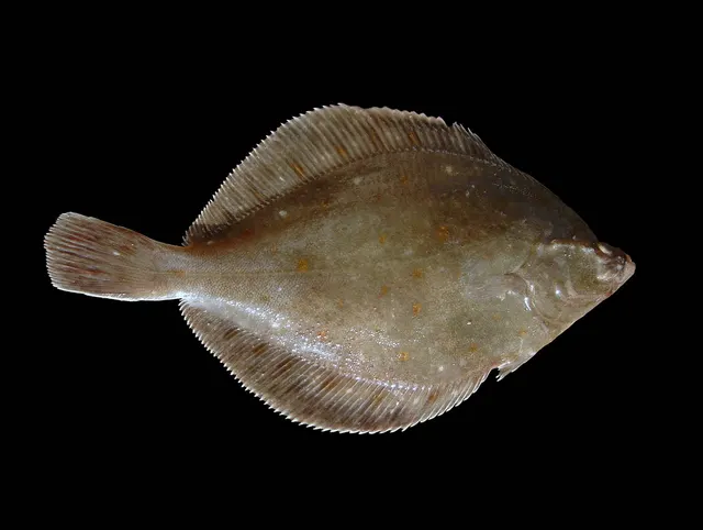 European plaiceSeasonal1 placeSouthwold PierOver pierAround Jun–Sept
 European sea bassSeasonal1 placeSouthwold PierOver pierAround Jun–Sept
 Thick-lipped grey mulletSeasonal1 placeSouthwold PierOver pierAround Jun–Sept
 WhitingSeasonal1 placeSouthwold PierOver pierAround Jan–Feb, Nov–Dec
What these strengths mean
- Regular local target
- Fishing sources describe this as a normal local target here, not merely as caught.
- Seasonal
- Well supported, and concentrated in part of the year rather than spread through it.
- How breadth is counted
- A fish documented at six marks is shown as six marks: breadth never raises the strength on its own. A fishery account describes the fishing; a recorded catch reports one specific catch. How evidence is weighed.
Also associated with this ground
Recorded as present here without a documented method or strength behind them.
Fish documented nearby, not here
Nothing below has been documented at Southwold Pier itself. Each one has been documented at a named place on the same ground, and the places are listed with it. Treat this as what the water around here holds rather than as a catch list for this mark.
Widely documented on this ground
Documented at three or more neighbouring places, fished a way this place is also fished. That is a pattern about the ground rather than about any one mark, and it is the closest this site comes to saying you will probably meet a fish somewhere nothing has been written about.
From the shore
- Pouting — documented at Lowestoft Claremont Pier; The Orwell and Stour estuaries; Felixstowe and Landguard Point
Also documented at neighbouring places
One or two accounts each, on the ground around here. Enough to know the fish is caught in these waters; not enough to say anything about this place.
From the shore
- Small-spotted catshark — documented at Dunwich; Aldeburgh
- Starry smooth-hound — documented at Kessingland; Caister-on-Sea
- Atlantic mackerel — documented at Lowestoft Claremont Pier
How people fish it
Practised here: Sea fishing.
Methods the sources name for this ground. Each one is explained in full on its own page.
- Ledgering
Fishing a bait on the bottom held by a weight, with no float — the simplest way to fish at distance, in depth, or in wind.
The ground and the water
- The ground
- A rebuilt pleasure pier over clean sand and shingle, just north of the Blyth entrance and its training walls.
Getting there
What public sources describe, last checked 2026-08-25. Car parks fill, services change and a path existing is not a path anybody may use — none of this is a guarantee of availability and none of it is permission to be anywhere.
- Getting to it
- A working visitor pier at the north end of the Southwold front, reached on foot from the promenade, with shops and food along its length and the angling at the seaward end. Unlike most English piers this one sells a fishing permit rather than either prohibiting angling or ignoring it, and the permit is bought on the pier itself rather than in advance.
Where this access information comes from
- Fishing from Southwold Pier — the operator's own page — Southwold Pier (Local authority, harbour or protected-area body)Relied on for: That the operator permits fishing under a day permit obtainable from the units along the pier, sells an annual permit in March only, and states that a member of the Southwold Pier Angling Club is usually present.States this directlyPassage read and verified
What is there
Food or shelter
Several food outlets along the pier itself, operated by the pier. The units along the deck are also where a fishing permit is bought.
Through the year
The months the sources attach to each species here. Where a species carries no season it is listed underneath rather than assumed to run through the year.
| Species | J | F | M | A | M | J | J | A | S | O | N | D |
|---|---|---|---|---|---|---|---|---|---|---|---|---|
| Atlantic cod — seasonal, recorded in November, December, January, February. | ||||||||||||
| European plaice — seasonal, recorded in June, July, August, September. | ||||||||||||
| European sea bass — seasonal, recorded in June, July, August, September. | ||||||||||||
| Thick-lipped grey mullet — seasonal, recorded in June, July, August, September. | ||||||||||||
| Whiting — seasonal, recorded in November, December, January, February. |
Recorded here with no season stated: European flounder.
Safety
Cold water shock — Can cause serious injury or death
The North Sea on this coast is cold for most of the year and the fishery is weighted to winter nights. A person entering the water experiences an involuntary gasp and loss of breathing control within seconds, in turbid water with no visibility, frequently alone and in the dark.
What reduces it: Wear a buoyancy aid rather than carry one, do not fish alone at night, carry a means of calling for help on the person rather than in a bag, and tell somebody the beach and the return time. Treat a gently shelving beach as no safer than a steep one for immersion.
Worse when:
- Winter night sessions, which is when most of this fishing is done.
- Wading on a shallow-gradient beach where the apparent safety encourages going further out than intended.
Cliffs and rock platforms — Can cause serious injury or death
Cliffs of glacial till and sand collapse without warning, especially after rain and where the face is fresh rather than vegetated. Sitting at the base of a cliff for shelter on a cold beach places a person directly beneath the failure.
What reduces it: Do not shelter, sit or set up beneath a soft cliff at any time, and keep clear of the cliff edge above, which is undercut and may overhang. Use the open beach and dress for it instead.
Worse when:
- After heavy or prolonged rain, when saturated till slumps.
- Where the cliff face is bare and freshly exposed rather than vegetated and stable.
Boat safety — Can cause serious injury or death
Wind against tide over a shallow bank produces a steep breaking sea disproportionate to the wind strength. A modest breeze against a spring ebb over a bank creates conditions a kayak or small boat should not be in, and the transition from workable to dangerous happens over a bank edge rather than gradually.
What reduces it: Plan around the tide as well as the wind, avoid crossing bank edges on a wind-against-tide state, and treat the inshore waters forecast plus the tidal stream as one combined input rather than two. Deciding not to launch is a legitimate answer.
Worse when:
- Spring tides, when the streams over the banks are strongest.
- Any wind opposing the tidal stream, regardless of how light it feels on the beach.
Rules and access
FishingHQ does not know the current access position here. Shore angling in England is not rod-licensed, but access rights, landowner permission, local authority and harbour byelaws, national and inshore fisheries measures, and site designations all apply and all change. Check the current position with the relevant inshore fisheries and conservation authority, the harbour or local authority, and the landowner before going.
Particular to this water: The pier is privately operated and fishing from it requires a permit issued by the operator, obtainable from any of the units along the pier. An annual permit is sold, and the operator states it is available in March only. A member of the Southwold Pier Angling Club is usually on the pier.
Who holds the answer:
- The Inshore Fisheries and Conservation Authority for the district, which makes and enforces inshore byelaws.
- The Marine Management Organisation, for national recreational sea fishing measures in English waters.
- The local authority and, where one exists, the harbour authority, for access, byelaws and shellfish classification.
- The relevant Inshore Fisheries and Conservation Authority for the district, which makes and enforces inshore byelaws including those on bait collection.
- Natural England and the relevant protected site management body, where a designation affects access, vehicles or bait digging.
- The harbour authority or commissioners, where fishing is from harbour structures or where small craft are launched.
- The Maritime and Coastguard Agency and the RNLI, for safety guidance on this coast.
Nearby fishing
Other publicly documented places within about 40 km, by distance. Positions are approximate public geography and are never exact marks.
- Dunwich — 5–10 km · Beach
- Kessingland — 5–10 km · Beach
- Sizewell — 10–25 km · Beach
- Lowestoft Claremont Pier — 10–25 km · Pier
- The Waveney at Beccles — 10–25 km · River reach
- Aldeburgh — 10–25 km · Beach
- Gorleston pier — 25–40 km · Pier
- Great Yarmouth north beach — 25–40 km · Beach section
Sources for this place
- Sea Angler — Bauer Media (Specialist angling publication)Relied on for: Long-running published description of British sea angling practice by region, ground type and named mark.FishingHQ's interpretation of what it saysCitation checked — the work exists and is described correctly
- General angling website restatements of established technique — Various (Credible secondary source)Relied on for: Widely restated public descriptions of which places are conventionally fished and how, recorded as practitioner consensus rather than as scholarship, and not relied on for access, permission or any current rule.Background and mechanism onlyCitation checked — the work exists and is described correctly
- Fishing from Southwold Pier — the operator's own page — Southwold Pier (Local authority, harbour or protected-area body)Relied on for: The pier operator's own statement of its permit arrangements and of the fishing the pier produces.States this directlyPassage read and verified
- FISHMAG east coast sea fishing guide — Lincolnshire to the Thames — FISHMAG (Credible secondary source)Relied on for: The mark-by-mark east coast guide from Lincolnshire to the Thames: which species are taken at each named mark, with the bait, the season, the ground and the state of tide.States this directlyPassage read and verified
- British Sea Fishing: east of England shore marks — British Sea Fishing (Credible secondary source)Relied on for: The mark-by-mark east-of-England shore guide: species, bait, hook size, rig, season and ground at each named mark from the Wash to the Crouch.States this directlyPassage read and verified
How FishingHQ labels evidence is explained in the evidence policy. Last reviewed 2026-08-16.