Clay Lake
Reservoir · Fresh water · in Northern Ireland
A 49-hectare coarse reservoir near Keady, known for pike, some over 14 kg, and large perch, with rudd; a mostly stony shore that is fished only on its eastern side.
Safety: cold water shock — can cause serious injury or death (general advice, not specific to this place). One more point applies here.
FishingHQ describes what this place is, not whether you may fish it. Access, permits and who to ask.
What you can catch here
Documented at this place, grouped by how you would be fishing, with how strongly the sources support each one. This is what has been written down, not a forecast, and being listed is never permission to fish.
From the shore · 3
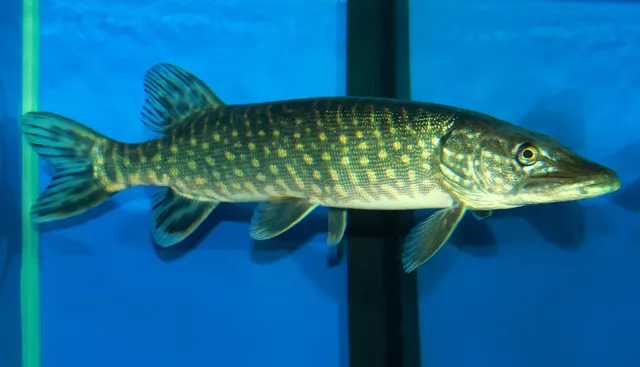 Northern pikeCharacteristic of this water1 placeClay LakeOver reservoir
Photo: Karelj, via Wikimedia Commons, public domain; resized and trimmed to fit
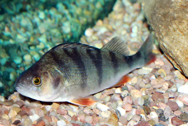 European perchRegular local target1 placeClay LakeOver reservoir
Photo: Karelj, via Wikimedia Commons, public domain; resized and trimmed to fit
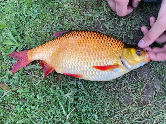 RuddRegular local target1 placeClay LakeOver reservoir
Photo: Stephanie Tran, via iNaturalist, CC BY; resized


What these strengths mean
- Characteristic of this water
- This water is strongly identified with this species by the sources that cover it.
- Regular local target
- Fishing sources describe this as a normal local target here, not merely as caught.
- How breadth is counted
- A fish documented at six marks is shown as six marks: breadth never raises the strength on its own. A fishery account describes the fishing; a recorded catch reports one specific catch. How evidence is weighed.
Fish documented nearby, not here
Nothing below has been documented at Clay Lake itself. Each one has been documented at a named place on the same ground, and the places are listed with it. Treat this as what the water around here holds rather than as a catch list for this mark.
Widely documented on this ground
Documented at three or more neighbouring places, fished a way this place is also fished. That is a pattern about the ground rather than about any one mark, and it is the closest this site comes to saying you will probably meet a fish somewhere nothing has been written about.
From the shore
- Roach — documented at The Erne at Enniskillen; The Upper Bann; The Blackwater (+6 more)
- Common bream — documented at The Erne at Enniskillen; The Upper Bann; The Blackwater (+3 more)
- Brown trout — documented at Castlewellan Forest Lake; Lough Brickland; Spelga Reservoir (+7 more)
- Rainbow trout — documented at Castlewellan Forest Lake; Hillsborough Lake; Lough Brickland (+5 more)
- Tench — documented at Killyfole Lough; Tullygiven Lough; Enagh Lough, Caledon (+1 more)
Also documented at neighbouring places
One or two accounts each, on the ground around here. Enough to know the fish is caught in these waters; not enough to say anything about this place.
From the shore
- Atlantic salmon — documented at Shimna River
- Common carp — documented at Cypress Pond, Castlewellan
How people fish it
Practised here: Coarse fishing, Predator fishing.
Methods the sources name for this ground. Each one is explained in full on its own page.
- Deadbaiting
Presenting a dead fish as bait for predators — a method that works because scavenging is normal predator behaviour, not an exception.
- Spinning
Casting an artificial lure and retrieving it so that it moves like something alive — the most direct form of lure fishing.
- Float fishing
Suspending a bait at a controlled depth beneath a buoyant indicator — the most visual, most controllable and most widely applicable method in angling.
Baits and lures for these fish
The baits and lures each of the fish above is commonly taken on, from that fish’s own page. This is what works for the fish, not a report of what people use on this particular water — local knowledge and the conditions on the day still decide.
Baits
- Lobworms and worms — for European perch
- Maggots — for European perch
- Sea deadbaits — for Northern pike
Lures
- Crankbaits — for Northern pike, European perch
- Soft plastics — for Northern pike, European perch
- Dry flies — for Rudd
- Jerkbaits — for Northern pike
- Jigs and jig heads — for European perch
- Spinnerbaits and bladed jigs — for Northern pike
- Spinners — for European perch
- Spoons — for Northern pike
How to catch them: Pike fishing · Perch fishing
The ground and the water
- The ground
- A 49-hectare coarse reservoir near Keady, known for pike, some over 14 kg, and large perch, with rudd; a mostly stony shore that is fished only on its eastern side.
Getting there
What public sources describe, last checked 2026-10-23. Car parks fill, services change and a path existing is not a path anybody may use — none of this is a guarantee of availability and none of it is permission to be anywhere.
- Getting to it
- From Keady, take the B3 towards Castleblayney for about 1.2 miles; the lake is on the left. DAERA lists no car park on site, and angler access is only along the eastern shore between the dam wall and the southern end near the Castleblaney Road.
Where this access information comes from
- Clay Lake — Department of Agriculture, Environment and Rural Affairs (DAERA) (Government fisheries body)Relied on for: DAERA's own page for this water: where it is, the fish, the methods, the season, the licence and permit, the bag limit and the facilities.States this directlyPassage read and verified
Through the year
Open all year, DAERA's page says.
Safety
Cold water shock — Can cause serious injury or death
General safety for this kind of ground, not a finding about this place.
Water around these islands stays cold enough all year to trigger cold water shock — involuntary gasping and hyperventilation on sudden immersion, which can cause somebody to inhale water in the first seconds regardless of swimming ability.
What reduces it: Wear a buoyancy aid where immersion is credible. If immersed, float on your back until the initial response passes rather than trying to swim immediately.
Slips, trips and falls — Can cause injury needing treatment
DAERA says the shore is mostly stony and safe for wading, but asks for caution in its softer areas.
What reduces it: Test the bottom before each step and stay out of the soft margins.
Rules and access
Licence
A rod licence is required, and Northern Ireland has two licensing authorities — DAERA and the Loughs Agency — covering different areas. Which one issues yours depends on where you are fishing.
Permission to fish
Separate, and both are needed. A rod licence plus a permit or day ticket for the specific water is the normal requirement here.
Particular to this water: DAERA's page, read on 23 October 2026, opens this water all year to all lawful methods and requires a DAERA coarse or game rod licence and a coarse or game fishing permit from age 12. Fishing is allowed only on the eastern shore between the dam wall and the southern end near the Castleblaney Road; stiles and footbridges have been removed. One pike up to 4 kg and four coarse fish up to 25 cm a day. No boats.
Beyond what is stated above, FishingHQ does not know the current access position here. Angling in Northern Ireland generally requires both a rod licence from the relevant fisheries body and a separate permit for the water, and the two are issued by different bodies. Rules, seasons and permit arrangements change. Check with the Department of Agriculture, Environment and Rural Affairs, the Loughs Agency where relevant, and the permit issuer before going.
Who holds the answer:
- The Department of Agriculture, Environment and Rural Affairs, for rod licensing and fisheries regulation.
- The Loughs Agency, in the Foyle and Carlingford catchments.
- The club, association or owner that issues the permit for the water.
- The Northern Ireland department responsible for agriculture, environment and rural affairs, for inland fisheries administration, rod licences and public angling permits across most of the jurisdiction.
- The cross-border loughs agency, which administers fisheries in the Foyle catchment and the Carlingford area across the frontier, and issues its own licences for those areas.
- The club, association, estate or private owner controlling the water, where the fishery is not publicly administered.
- The authority managing any marine protected area, area of special scientific interest or designated site, Strangford Lough in particular.
- The Department of Agriculture, Environment and Rural Affairs (DAERA), which holds the fishing on this water as part of its Public Angling Estate, sets its rules and sells the permit; a rod licence is needed as well.
Nearby fishing
Other publicly documented places within about 40 km, by distance. Positions are approximate public geography and are never exact marks.
- Enagh Lough, Caledon — 10–25 km · Lough
- Tullygiven Lough — 10–25 km · Lough
- Brantry Lough — 10–25 km · Lough
- White Lough, Aughnacloy — 10–25 km · Lough
- Lough Brickland — 25–40 km · Lough
- The Blackwater — 25–40 km · River reach
- The Upper Bann — 25–40 km · River reach
- Craigavon City Park Lake (South) — 25–40 km · Lake
Sources for this place
- Clay Lake — Department of Agriculture, Environment and Rural Affairs (DAERA) (Government fisheries body)Relied on for: DAERA's own page for this water: where it is, the fish, the methods, the season, the licence and permit, the bag limit and the facilities.States this directlyPassage read and verified
- Angling rod licences explained — nidirect (Northern Ireland Government) (Local authority, harbour or protected-area body)Relied on for: Where Northern Ireland rod licences and DAERA permits are bought.States this directlyPassage read and verified
How FishingHQ labels evidence is explained in the evidence policy. Last reviewed 2026-10-23.
Something wrong or out of date?
If something on this page has changed, email us from your own account using the link that fits, with a link to where you saw the change if you can. Every report is checked by a person before anything is changed, and a report never appears on the site by itself. Please don’t send exact private marks.
Before you go
- Fish documented here
- 3 at this place itself. See them.
- Getting there
- Described from public sources, last checked 2026-10-23. Getting there.
- Rules particular to this water
- DAERA's page, read on 23 October 2026, opens this water all year to all lawful methods and requires a DAERA coarse or game rod licence and a coarse or game fishing permit from age 12. Fishing is allowed only on the eastern shore between the dam wall and the southern end near the Castleblaney Road; stiles and footbridges have been removed. One pike up to 4 kg and four coarse fish up to 25 cm a day. No boats. From the body that sets it: Department of Agriculture, Environment and Rural Affairs (DAERA) and nidirect (Northern Ireland Government), read 2026-10-23. Applies to: Clay Lake.
Nothing here is watched for change. Sources and who to ask.
- Hazards particular to this place
- 1 recorded. Safety.
Check before you travel
- Whether you may fish here, and whether a licence or permit is needed — start with the Department of Agriculture.
- Who holds the fishing right on the water you mean to fish.
- Anything recorded here was true when it was read; it is not watched for change.