The Wadden Sea
Fishing regions · Last reviewed 2026-08-16
Five hundred kilometres of tidal flat behind a chain of barrier islands, running across three countries: the largest unbroken intertidal system on earth and the nursery for a very large share of the southern North Sea.
Safety: tides and being cut off — can cause serious injury or death. 3 more points apply here.
Contamination and toxins in the catch — Can cause injury needing treatment
Bivalves filter the water they sit in and concentrate marine biotoxins and microbiological contamination. Neither cooking nor appearance removes a biotoxin, and harvesting areas are opened and closed on monitoring a gatherer cannot see.
What reduces it: Check the current harvesting area classification and closures with the local food-safety authority for the country you are in before taking anything.
Being listed here is not permission to fish. What that meansClose
Access, fishing rights, seasons, licences, local bylaws and permitted methods vary and can change. Check current access, permission, local regulations, closures and restrictions before you travel or fish. FishingHQ describes what the ground is and names who holds the answer; it does not hold the answer itself.
Find the authority for a jurisdiction · What FishingHQ does and does not cover
The Wadden Sea is a system-tier record because it is one continuous physical machine running from the Netherlands through Germany to Denmark, and dividing it by border would describe the same thing three times.
WHAT IT PHYSICALLY IS. A chain of low barrier islands lies a few kilometres off the continental coast, and between them and the mainland is a shallow basin that empties and fills twice a day. At low water an enormous continuous area of sand and mud flat is exposed — the largest such system anywhere — cut by deep tidal channels and by the gaps between the islands through which the whole exchange passes.
THE SCALE IS THE FIRST FACT AND IT IS DIFFICULT TO OVERSTATE. Roughly five hundred kilometres of coast, thousands of square kilometres of flat, and a tidal exchange that moves an enormous volume through a small number of gaps four times a day. It is designated at the highest available international level for exactly that reason.
THE SECOND FACT IS THAT IT IS A NURSERY RATHER THAN A FISHERY. Shallow, warm in summer, food-rich, turbid and largely inaccessible to large predators, this is where a very large share of the southern North Sea's plaice, sole, herring and other species spend their first year or two. Adults fished across a much wider area grew up here, which is the whole argument for the protection over it.
THE THIRD IS THE SHELLFISH AND THE BIRDS, WHICH ARE THE SAME ARGUMENT. Mussel and cockle beds support commercial fisheries and feed migratory wader and wildfowl populations of global significance, and the allocation between those uses is the defining management dispute of the system — argued out publicly and in court, in all three countries, for decades.
WHAT AN ANGLER ACTUALLY FINDS is a shore fishery of flatfish, bass, mullet and eel from dyke, groyne, harbour and beach; a substantial fishery on the island seaward beaches; and access constraints that are heavier than almost anywhere else in Europe because the whole system is protected.
AND SEALS ARE A VISIBLE PART OF IT. Both harbour and grey seals breed on the sandbanks in numbers, which is a genuine ecological recovery and a practical consideration for anybody working the flats.
What fishing here is like
A shallow tidal basin roughly five hundred kilometres long lying between a chain of low barrier islands and the continental coast of the Netherlands, Germany and Denmark. At low water it exposes the largest continuous area of sand and mud flat on earth, cut by deep tidal channels and drained through a small number of gaps between the islands through which the entire exchange passes at speed. Water is shallow, turbid, warm in summer and cold in winter, with a strong salinity gradient near the freshwater outfalls. The seaward side of the islands is open North Sea beach; the landward side is dyke, saltmarsh and reclaimed polder below sea level.
How people fish here
4 methods are recorded on the places documented here, counted from the records themselves rather than from what is practised in the country. Each opens a full guide to the technique.
Surfcasting
Recorded at 3 places here, over island.
Casting heavy baited tackle from a beach into surf — a method defined by distance, by tide, and by reading water that all looks the same.
Ledgering
Recorded at 2 places here, over island.
Fishing a bait on the bottom held by a weight, with no float — the simplest way to fish at distance, in depth, or in wind.
Spinning
Recorded at 2 places here, over island.
Casting an artificial lure and retrieving it so that it moves like something alive — the most direct form of lure fishing.
Kayak fishing
Recorded at 1 place here, over island.
A platform rather than a technique: quiet, shallow-draught access to water no other craft reaches, bought at the price of exposure, and a discipline where the decision not to launch is part of the skill.
These are the methods documented at the places FishingHQ holds here. A species listed beside a method is documented on the same ground, which is not the same as being taken that way — where a source establishes the method a fish was caught on, it is stated on that place’s own page. All fishing methods.
What dominates
Shore fishing from dyke, groyne, harbour wall, sluice and the seaward island beaches, which is how most rod fishing here is done. Small-boat fishing in the channels and the gaps between islands, constrained absolutely by the drying ground and the streams. Bass, mullet and flatfish fishing around the sluices and outfalls where fresh water enters. Eel fishing, historically enormous and now constrained by the species' conservation status. Commercial and permitted shellfish gathering for mussel and cockle, which is the system's principal harvest and its principal management dispute. Bait digging on the flats, heavily regulated. Guided mudflat walking, which is a recognised regional activity and exists because the flats kill people who go unaccompanied.
The water available
The largest continuous intertidal sand and mud flat system on earth; deep tidal channels and inter-island gulleys carrying the whole exchange; extensive mussel, cockle and seagrass beds; saltmarsh and dyke frontage; open North Sea barrier-island beaches with surf and groyne fields; sluices and outfalls where managed fresh water enters; brackish transition zones; and sandbanks used by breeding seal populations.
How the rules are structured
Three national frameworks apply along the same physical system, which is the practical complication here. The Netherlands, Germany and Denmark each administer their own recreational and commercial fisheries rules, and they differ in licensing, size limits, permitted methods and shore access. In all three the whole system carries the heaviest tier of nature protection available, including World Heritage inscription and national park designation in places, and those designations constrain access, vehicles, dogs, collection and the timing of activity independently of any fishing rule — in several zones access is prohibited or seasonal. Shellfish harvesting is licensed and quota-managed and harvesting areas are classified for food safety. Eel is subject to specific measures across the European Union reflecting its conservation status. FishingHQ does not state what any current rule is, and it is more than usually important here that the reader checks the rule for the specific country and zone.
Who to ask
- The national fisheries authority of the country concerned — the Netherlands, Germany or Denmark — whose recreational rules, licensing and size limits differ from each other along the same system.
- The national park or protected-area authority for the zone, which governs access, vehicles, dogs, collection and seasonal closures independently of fishing rules.
- The trilateral Wadden Sea cooperation, which coordinates conservation across the three countries and publishes the shared scientific assessment.
- The regional water and dyke authority, for access to dykes, sluices and outfalls, which are working flood-defence infrastructure.
- The local food-safety authority, for shellfish harvesting area classification and closures.
Words you will meet
- Wad or Watt
- The tidal flat itself. The word names the exposed sea bed at low water, and 'wadlopen' or mudflat walking — crossing it on foot at low tide, always with a qualified guide — is a recognised regional activity precisely because the flat is dangerous to cross alone.
- Priel
- A tidal creek or gully draining a section of flat. Priels fill first and fastest on the flood and are the specific feature that cuts people off, because one that was ankle-deep on the way out becomes an impassable moving channel on the way back.
- Sluice
- A controlled outfall through the dyke where managed fresh water is discharged to the sea. Sluices concentrate food, fish and anglers, they are working infrastructure rather than fishing venues, and the discharge is a management decision rather than a natural flow.
Conditions and hazards
The flats here have killed a great many people and the mechanism is always the same. Across ground this level a small vertical rise is an enormous horizontal advance, and the water does not arrive from the sea in front — it fills the priels and channels first and spreads outward and backward from them, so it appears between a person and the dyke while the sand they are standing on is still dry. Channels migrate between tides, so a firm route used last week may not exist, and saturated ground that carried weight on the way out may not on the way back. Fog is frequent and the flats have no landmarks at all, which removes the only navigation available. That combination is why guided mudflat walking exists as a regulated activity and why the standing advice across all three countries is not to cross the flats unaccompanied. Afloat, the streams through the gaps between the islands run hard enough to overwhelm a small craft and the seaward beaches carry North Sea surf and rip currents. Water is cold enough for most of the year for cold water shock to decide an immersion, and shellfish taken here carry a food-safety hazard entirely independent of the walk.
Three countries, one sea bed, and rules that stop at every border
The Wadden Sea is a single continuous physical system governed by three national administrations, and the mismatch between those two facts is the most practically important thing about it for a visiting angler.
THE PHYSICS DOES NOT KNOW ABOUT THE BORDERS. Water, sediment, fish larvae, migratory birds and seals move along the whole system. A management decision on one section affects the others, and the science has to be done jointly for it to mean anything — which is why the three countries operate a formal trilateral cooperation that produces a shared assessment of the system's condition.
THE RULES ABSOLUTELY DO KNOW ABOUT THE BORDERS. Recreational fishing licensing, size limits, permitted methods, shore access, bait collection and shellfish gathering are national or regional matters and they differ. An angler moving along this coast crosses between frameworks that look superficially similar and are not the same, and the assumption that a rule learned in one country applies in the next is the specific error to avoid.
THE CONSERVATION LAYER IS HEAVIER THAN THE FISHERIES LAYER, and this catches people out. The whole system carries the highest tier of international protection available, with national park designation across large parts of it. That means zoning: areas where access is prohibited outright, areas where it is seasonal, areas where vehicles or dogs are excluded, and areas where collection of anything is not permitted. Those constraints are independent of any fishing rule and they are enforced. A place that is legally fishable under fisheries law may be a place a person may not stand.
THE DYKES AND SLUICES ARE INFRASTRUCTURE RATHER THAN VENUES. Much of the accessible fishing here is from flood-defence works, and those are operated by water authorities with their own access rules and their own operational priorities. A sluice discharges when the authority decides, not when the fishing would benefit.
AND THE SHELLFISH SIT UNDER TWO FRAMEWORKS AT ONCE, which is a distinction worth keeping clear. The fishery framework decides who may take what, how much and with what gear. The food-safety framework classifies harvesting areas and opens and closes them on biotoxin and microbiological monitoring. Those are different bodies answering different questions, and satisfying one says nothing about the other.
WHAT FOLLOWS FOR A READER. Ask the national fisheries authority for the country, and separately ask the protected-area authority for the zone. FishingHQ does not state what any of it says, and on this system in particular the answer differs by a few kilometres of coast.
Official guidance — why, and the sources (2)
Stated by a fisheries authority, scientific institute or recognised angling body. Authoritative, but summarising rather than demonstrating.
- Code of Conduct for Responsible Fisheries — Food and Agriculture Organization of the United Nations, Rome, 1995 (Standards body)Relied on for: The international framework within which national and regional fisheries authorities set, revise and enforce measures, and the principle that responsible fishing includes the safety of fishers.Background and mechanism onlyCitation checked — the work exists and is described correctly
- Shellfish classification — Food Standards Agency, 2026 (Government fisheries body)Relied on for: That shellfish harvesting areas are classified, that the classification governs what may be taken and how it must be treated, and that it is set and revised by the authority on monitoring results rather than fixed.States this directlyCitation checked — the work exists and is described correctly
Why crossing the flat alone is the thing nobody local does
This system has a long fatality record and the mechanism has been the same every time. It is worth setting out precisely, because the reason people die here is that the danger does not look like one.
THE GROUND IS FLAT AND THE CONSEQUENCE IS ARITHMETIC. On a surface this level, a small vertical rise translates into an enormous horizontal advance. The flood covers ground faster than a person can walk over soft going, and it does it as unremarkable shallow water. Nobody is knocked down by this tide; they are simply unable to move as fast as it fills.
AND IT DOES NOT COME FROM THE SEA IN FRONT. The priels — the tidal creeks that drain each section of flat — fill first, and water spreads outward and backward from them. So the sea appears between a person and the dyke while the sand under their feet is still dry, and somebody watching the horizon is watching the wrong direction entirely.
THE PRIEL IS THEN THE SPECIFIC TRAP. A creek that was ankle-deep on the walk out is a moving channel, deeper and faster than the flat either side of it, on the walk back. It is the thing between a person and the shore, and it is the last obstacle rather than the first.
THE GROUND CHANGES STATE AND THE CHANNELS MOVE. Saturated sand and mud that bore weight on the way out may not on the way back, and the channels migrate between tides, so a route that worked last week may not exist today. Being stuck out there on a rising tide is not a delay; it is the whole mechanism.
FOG REMOVES THE ONLY NAVIGATION AVAILABLE. There are no landmarks on a flat. A person who can see the dyke can walk to it; a person in fog on a featureless plain with water rising behind them has lost the ability to choose a direction, and fog is frequent on this coast.
WHICH IS WHY GUIDED MUDFLAT WALKING EXISTS AS A REGULATED ACTIVITY HERE. Crossing the flats on foot is a recognised regional pursuit and it is done with qualified guides, on planned routes, at planned times, because the local judgement is that it cannot be done safely otherwise. The standing advice across all three countries is not to go out onto the flats unaccompanied, and that is a genuine local instruction rather than a liability formula.
AFLOAT, THE GAPS BETWEEN THE ISLANDS ARE THE HAZARD. The entire tidal exchange of a basin section passes through each gap, so the streams there run hard enough to overwhelm a small craft, and wind against them stands the water up sharply. The seaward island beaches carry ordinary North Sea surf with rips where the water returns.
COLD WATER RUNS UNDER ALL OF IT for most of the year, and the shellfish carry a separate hazard entirely: bivalves filter what they sit in, harvesting areas are classified and closed on monitoring nobody can see from the sand, and cooking does not remove a biotoxin. Check with the local authority before taking anything.
Official guidance — why, and the sources (3)
Stated by a fisheries authority, scientific institute or recognised angling body. Authoritative, but summarising rather than demonstrating.
- RNLI water safety guidance: cold water shock and Float to Live — Royal National Lifeboat Institution (Water-safety or diver-training authority)Relied on for: Cold water shock and the immersion response, tidal cut-off, and water-safety guidance for shore anglers and small-craft users.States this directlyPassage read and verified
- Met Office shipping forecast, inshore waters forecast and marine warnings — Met Office, United Kingdom (Government fisheries body)Relied on for: That inshore waters forecasts, sea state and swell are the operative inputs for shore and small-craft decisions in north-west European waters.States this directlyCitation checked — the work exists and is described correctly
- Shellfish classification — Food Standards Agency, 2026 (Government fisheries body)Relied on for: That shellfish harvesting areas are classified, that the classification governs what may be taken and how it must be treated, and that it is set and revised by the authority on monitoring results rather than fixed.States this directlyCitation checked — the work exists and is described correctly
Some of what lives here
Fish recorded here that FishingHQ holds a reviewed photograph of. It is not a complete list of what The Wadden Sea holds, and it is not a prediction that you will catch any of them — it is a way in to the ones we can show you.
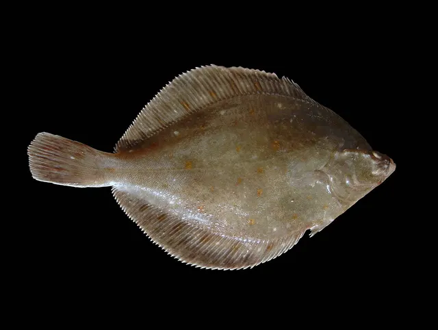 European plaiceA right-eyed flatfish with orange spots and a remarkable lifespan, and the representative flatfish for a body plan nothing else on FishingHQ shares.
Hans Hillewaert — CC BY-SA 4.0, via Wikimedia Commons
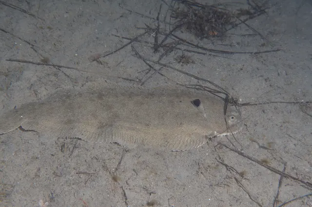 Common soleA nocturnal, sand-dwelling flatfish with a rounded head and a small twisted mouth, and one of the most valuable food fish in European waters.
Julien Renoult — CC BY, via iNaturalist
 European flounderThe flatfish that runs up rivers — a tolerant, estuarine right-eyed flounder with bony tubercles along its fin bases and a habit of turning up in fresh water.
nbasargin — CC BY, via iNaturalist
 European sea bassA fast, predatory inshore fish that hunts in broken water and surf, and one of the most closely managed recreational species in European seas.
Julien Renoult — CC BY 4.0, via Wikimedia Commons
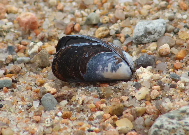 Blue musselThe commonest gathered shellfish on Atlantic European shores, attached to rock by threads it spins itself, and an animal whose safety is decided entirely by the water it grew in.
Steven Lamonde — CC BY, via iNaturalist
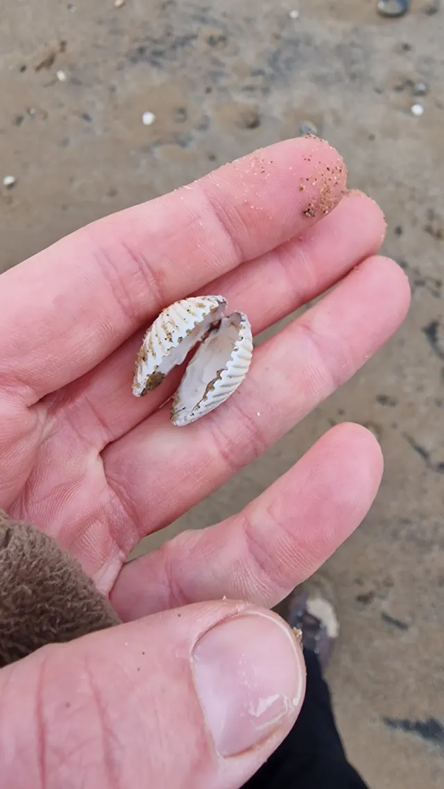 Common cockleA ribbed bivalve living just under the surface of intertidal sand and mud, gathered by rake and by foot, and the animal behind one of the most dangerous gathering fisheries there is.
bitsandbugs — CC0, via iNaturalist
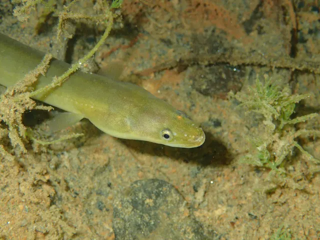 European eelA Critically Endangered fish that breeds in the Sargasso Sea, drifts to Europe as a transparent larva, lives decades in fresh water and returns once to spawn and die.
jujurenoult — CC BY 4.0, via Wikimedia Commons
Places within this area
Publicly documented fishing geography. FishingHQ describes what the ground is; it does not say whether you may fish it, and every one of these sends that question to the body that holds the answer. Browse every place in this part of the world.
Who to ask before fishing any of these
FishingHQ does not know the current access position here. Denmark runs a single national fishing licence covering both sea and fresh water for those it applies to, and it is not a permission to fish anywhere: protected zones around river mouths, closed seasons for sea trout in colour, size and quantity measures, and local restrictions all apply and change. Check the current position with the Danish fisheries agency before going. This water is tidal and transitional, so the freshwater regime may also apply above the tidal limit: FishingHQ does not know the current access position here. The national licence is only half of what an inland angler needs — almost every river and lake also requires a separate day ticket or association membership from whoever holds the fishing right. Seasons and measures change. Check with the Danish fisheries agency and with the association or owner controlling the water before going.
FishingHQ does not know the current access position here, and Germany's structure surprises visitors more than most. In most of the country a fishing licence is issued only after a formal examination in fish biology, law and welfare — the qualification comes before the paper — and the arrangements for the Baltic and North Sea coasts differ between the coastal states. Species measures, closed seasons and protected areas apply and change. Check the current position with the fisheries authority of the state before going. This water is tidal and transitional, so the freshwater regime may also apply above the tidal limit: FishingHQ does not know the current access position here. German inland angling needs two separate things: the state fishing licence, which in most states follows an examination, and a permit for the specific water, which is sold by whoever holds the fishing right — usually a club, a commune or a private owner. Neither substitutes for the other, both differ between the sixteen states, and both change. Check with the state fisheries authority and with the water's rights-holder before going.
FishingHQ does not know the current access position here. Shore angling on the Dutch coast is largely open, but species and size measures apply, sea bass in particular is managed tightly and changes year to year, and access to dikes, piers, sluices and the Delta works is controlled by the authority that owns the structure. Check the current position with the national angling federation and with the water authority before going. This water is tidal and transitional, so the freshwater regime may also apply above the tidal limit: FishingHQ does not know the current access position here. Dutch inland angling runs through a single document issued by the angling federation and its member associations, which functions as both the licence and the permission for the waters listed with it — and a water not on that list needs its own arrangement. Methods, seasons and the night-fishing and third-rod permissions are separate again, and all of them change. Check with the national angling federation and the local association before going.
Fanø
Island · Brackish water
A Danish Wadden barrier island with a very wide flat sand beach on its seaward side, dunes behind it, and drying mud and sand flats between the island and the mainland cut by tidal channels.
The seaward beach takes the open North Sea; the landward side is inside the Wadden and is sheltered from swell entirely.
Particular to this ground: tides and being cut off, cold water shock.
Severe hazards of The Wadden Sea apply here: drowning and immersion, moving water and currents.
Particular to this water: This ground lies in or beside a marine protected area whose zoning constrains fishing, diving, anchoring and collection independently of any licence, with rules that differ between zones and boundaries that are not visible from the water. Shellfish harvesting areas are classified for food safety and are opened and closed on monitoring results a gatherer cannot see. Neither cooking nor appearance removes a biotoxin. Check the current classification with the responsible authority before taking anything.
Sylt
Island · Brackish water
A long narrow German Wadden barrier island with a straight open North Sea beach and groyne field on its western side, dunes and cliff behind, and drying mud and sand flats with tidal channels on the landward side.
The western beach takes the open North Sea and is heavily defended against erosion; the eastern side is inside the Wadden and takes no swell at all.
Particular to this ground: tides and being cut off, cold water shock.
Severe hazards of The Wadden Sea apply here: drowning and immersion, moving water and currents.
Particular to this water: This ground lies in or beside a marine protected area whose zoning constrains fishing, diving, anchoring and collection independently of any licence, with rules that differ between zones and boundaries that are not visible from the water.
Texel
Island · Brackish water
The largest of the Dutch Wadden barrier islands, with a long open North Sea beach and groyne field on the west, dunes behind it, and drying flats, mussel beds and deep tidal channels on the landward side towards the mainland.
The western beach takes the open North Sea; the Marsdiep channel between the island and the mainland is sheltered from swell and dominated by an extremely strong tidal stream.
Particular to this ground: tides and being cut off, cold water shock.
Severe hazards of The Wadden Sea apply here: drowning and immersion, moving water and currents.
Particular to this water: This ground lies in or beside a marine protected area whose zoning constrains fishing, diving, anchoring and collection independently of any licence, with rules that differ between zones and boundaries that are not visible from the water. Shellfish harvesting areas are classified for food safety and are opened and closed on monitoring results a gatherer cannot see. Neither cooking nor appearance removes a biotoxin. Check the current classification with the responsible authority before taking anything.
Safety
Contamination and toxins in the catch is set out at the top of this page, where it cannot be missed.
Tides and being cut off — Can cause serious injury or death
Across the largest intertidal flat on earth, a small vertical rise becomes an enormous horizontal advance. The flood fills the priels and channels first and spreads outward, so water appears between a person and the dyke while the sand they stand on is still dry, and the creek crossed on the way out is impassable on the way back.
What reduces it: Do not go out onto the flats unaccompanied — guided crossing exists here precisely because local judgement is that it cannot be done safely alone. Set a leaving time from the tide, and treat water appearing behind you as the signal to go immediately.
Worse when:
- In fog, which is frequent and removes the only navigation a featureless flat offers.
- On spring tides, when the advance is fastest and reaches furthest.
Drowning and immersion — Can cause serious injury or death
Saturated ground that carried weight on the way out will not necessarily carry it on the way back, and the channels migrate between tides so a firm route may no longer exist. Somebody stuck on a flat with a rising tide cannot free themselves.
What reduces it: Go with somebody who knows that specific ground and tide, tell somebody ashore the plan and the return time, carry a means of calling for help on the person, and wear flotation.
Moving water and currents — Can cause serious injury or death
The entire tidal exchange of each basin section passes through the gaps between the barrier islands, so the streams there run hard enough to overwhelm a small craft, and wind against them stands the water up sharply.
What reduces it: Plan any passage through a gap around the state of the tide rather than the wind alone, never enter with wind against stream, and treat local knowledge of the timing as essential rather than useful.
Further safety reading
- Tides and being cut off — Across the largest intertidal flat on earth the flood fills the priels first and spreads outward, so water appears between a person and the dyke while the sand is still dry. Guided crossing exists here because local judgement is that the flats cannot be crossed safely alone.
Check the rules before you fish
Fishing laws, bylaws, access rules, seasons, bait restrictions and permitted methods vary by location and can change. Check the current rules from the relevant authority and the water you intend to fish before fishing.
Check with:
- Current national or regional law for where you are fishing
- Current local bylaws
- The relevant fisheries authority
- The landowner, club or fishery whose water it is
- Any restrictions specific to the species or the method you intend to use
Where to go next
What swims here
- Atlantic herringThe system is significant juvenile habitat for herring as well as flatfish, which is part of why its protection is argued for on grounds far wider than its own fishery.
- Blue musselExtensive mussel beds across the flats support commercial fisheries and simultaneously feed migratory wader and wildfowl populations of global significance, which is the system's defining management dispute.
- Common cockleOn the flats in quantity, subject to a licensed and quota-managed fishery whose mechanical methods have been restricted, litigated and in places prohibited across the three countries.
- Common soleAs with plaice, the flats are significant juvenile habitat and the species is fished as an adult over a much wider area than it is grown in.
- European eelThrough the channels, sluices and brackish transitions. Given the species' critically endangered status the association is a distributional fact and encounters are handled under the constraints that status requires.
- European flounderThroughout the channels, creeks and brackish transitions around the sluices, where the salinity gradient and the soft ground are exactly the habitat, and present through the year.
- European plaiceThe largest intertidal system on earth is a nursery of first importance for this species, so juveniles are abundant across the flats and a substantial share of the adults caught across the southern North Sea grew up here.
- European sea bassAlong the barrier-island beaches and into the channels and around the sluices in the warmer months, at what has been the northern edge of the species' consistent continental range and is moving.
Local knowledge
How this compares
Environment and conservation
Sources and evidence
- ICES Advice on fishing opportunities, catch and effort — International Council for the Exploration of the Sea (Scientific institute)Relied on for: Ecoregion description, stock distribution, nursery function and the hydrography of the European sea areas assessed.States this directlyCitation checked — the work exists and is described correctly
- Cefas science, advice and data on marine and freshwater environments — Centre for Environment, Fisheries and Aquaculture Science (Government fisheries body)Relied on for: Marine environmental science for north-west European shelf seas, including tidal range and stream, sediment characterisation, estuarine and intertidal process.States this directlyCitation checked — the work exists and is described correctly
- JNCC species and habitat conservation advice — Joint Nature Conservation Committee (Conservation authority)Relied on for: Designation, habitat description and conservation status of the marine, coastal and freshwater habitats named, and the species characteristically associated with them.States this directlyCitation checked — the work exists and is described correctly
- FishBase: a global information system on fishes — Froese, R. and D. Pauly, eds. — FishBase Consortium (Scientific institute)Relied on for: Recorded distribution, depth range, habitat association and biology of the species named.States this directlyPassage read and verified
- RNLI water safety guidance: cold water shock and Float to Live — Royal National Lifeboat Institution (Water-safety or diver-training authority)Relied on for: Cold water shock and the immersion response, tidal cut-off, and water-safety guidance for shore anglers and small-craft users.States this directlyPassage read and verified
- Met Office shipping forecast, inshore waters forecast and marine warnings — Met Office, United Kingdom (Government fisheries body)Relied on for: That inshore waters forecasts, sea state and swell are the operative inputs for shore and small-craft decisions in north-west European waters.States this directlyCitation checked — the work exists and is described correctly
Why the 14 connections on this page are here, and the sources
What swims here
Backed by research — 8 connections
Supported by peer-reviewed research or fisheries science. The sources are listed and can be checked.
Atlantic herring
A claim that a place contains the ground, water and seasonal conditions the species is associated with. It is a distributional statement about the world, it rests on the regional reference literature, and it deliberately asserts nothing about access, permission or catch.
- JNCC species and habitat conservation advice — Joint Nature Conservation Committee (Conservation authority)Relied on for: Habitat classification and description for the intertidal, coastal and freshwater habitats named, and the species characteristically associated with them.States this directlyCitation checked — the work exists and is described correctly
- ICES Advice on fishing opportunities, catch and effort — International Council for the Exploration of the Sea (Scientific institute)Relied on for: Ecoregion description, nursery function and the hydrography of the European sea areas assessed.States this directlyCitation checked — the work exists and is described correctly
Blue mussel
A claim that a place contains the ground, water and seasonal conditions the species is associated with. It is a distributional statement about the world, it rests on the regional reference literature, and it deliberately asserts nothing about access, permission or catch.
- JNCC species and habitat conservation advice — Joint Nature Conservation Committee (Conservation authority)Relied on for: Habitat classification and description for the intertidal, coastal and freshwater habitats named, and the species characteristically associated with them.States this directlyCitation checked — the work exists and is described correctly
- ICES Advice on fishing opportunities, catch and effort — International Council for the Exploration of the Sea (Scientific institute)Relied on for: Ecoregion description, nursery function and the hydrography of the European sea areas assessed.States this directlyCitation checked — the work exists and is described correctly
Common cockle
A claim that a place contains the ground, water and seasonal conditions the species is associated with. It is a distributional statement about the world, it rests on the regional reference literature, and it deliberately asserts nothing about access, permission or catch.
- JNCC species and habitat conservation advice — Joint Nature Conservation Committee (Conservation authority)Relied on for: Habitat classification and description for the intertidal, coastal and freshwater habitats named, and the species characteristically associated with them.States this directlyCitation checked — the work exists and is described correctly
- ICES Advice on fishing opportunities, catch and effort — International Council for the Exploration of the Sea (Scientific institute)Relied on for: Ecoregion description, nursery function and the hydrography of the European sea areas assessed.States this directlyCitation checked — the work exists and is described correctly
Common sole
A claim that a place contains the ground, water and seasonal conditions the species is associated with. It is a distributional statement about the world, it rests on the regional reference literature, and it deliberately asserts nothing about access, permission or catch.
- JNCC species and habitat conservation advice — Joint Nature Conservation Committee (Conservation authority)Relied on for: Habitat classification and description for the intertidal, coastal and freshwater habitats named, and the species characteristically associated with them.States this directlyCitation checked — the work exists and is described correctly
- ICES Advice on fishing opportunities, catch and effort — International Council for the Exploration of the Sea (Scientific institute)Relied on for: Ecoregion description, nursery function and the hydrography of the European sea areas assessed.States this directlyCitation checked — the work exists and is described correctly
European eel
A claim that a place contains the ground, water and seasonal conditions the species is associated with. It is a distributional statement about the world, it rests on the regional reference literature, and it deliberately asserts nothing about access, permission or catch.
- FishBase: a global information system on fishes — Froese, R. and D. Pauly, eds. — FishBase Consortium (Scientific institute)Relied on for: Recorded distribution, depth range and habitat association for the species named.States this directlyPassage read and verified
- The Fishes of the British Isles and North-West Europe — Macmillan, 1969 (Reference work)Relied on for: Distribution and habitat association of the fishes of north-west Europe, including the continental coasts and seas named.States this directlyCitation checked — the work exists and is described correctly
European flounder
A claim that a place contains the ground, water and seasonal conditions the species is associated with. It is a distributional statement about the world, it rests on the regional reference literature, and it deliberately asserts nothing about access, permission or catch.
- FishBase: a global information system on fishes — Froese, R. and D. Pauly, eds. — FishBase Consortium (Scientific institute)Relied on for: Recorded distribution, depth range and habitat association for the species named.States this directlyPassage read and verified
- The Fishes of the British Isles and North-West Europe — Macmillan, 1969 (Reference work)Relied on for: Distribution and habitat association of the fishes of north-west Europe, including the continental coasts and seas named.States this directlyCitation checked — the work exists and is described correctly
European plaice
A claim that a place contains the ground, water and seasonal conditions the species is associated with. It is a distributional statement about the world, it rests on the regional reference literature, and it deliberately asserts nothing about access, permission or catch.
- JNCC species and habitat conservation advice — Joint Nature Conservation Committee (Conservation authority)Relied on for: Habitat classification and description for the intertidal, coastal and freshwater habitats named, and the species characteristically associated with them.States this directlyCitation checked — the work exists and is described correctly
- ICES Advice on fishing opportunities, catch and effort — International Council for the Exploration of the Sea (Scientific institute)Relied on for: Ecoregion description, nursery function and the hydrography of the European sea areas assessed.States this directlyCitation checked — the work exists and is described correctly
European sea bass
A claim that a place contains the ground, water and seasonal conditions the species is associated with. It is a distributional statement about the world, it rests on the regional reference literature, and it deliberately asserts nothing about access, permission or catch.
- FishBase: a global information system on fishes — Froese, R. and D. Pauly, eds. — FishBase Consortium (Scientific institute)Relied on for: Recorded distribution, depth range and habitat association for the species named.States this directlyPassage read and verified
- The Fishes of the British Isles and North-West Europe — Macmillan, 1969 (Reference work)Relied on for: Distribution and habitat association of the fishes of north-west Europe, including the continental coasts and seas named.States this directlyCitation checked — the work exists and is described correctly
How people fish here
What experienced anglers do — 2 connections
Widely and independently recommended by experienced anglers and specialist sources. This is real angling knowledge, not proof: controlled evidence for it is limited, and FishingHQ records it as convention rather than as a demonstrated effect.
Sea fishing
A claim about angling convention rather than about the world: that this place sits within this branch of fishing, which drives the information architecture as well as the page. It rests on independent practitioner description.
- General angling website restatements of established technique — Various (Credible secondary source)Relied on for: Widely restated descriptions of which practices are conventionally used in the waters named, recorded as practitioner consensus rather than as scholarship.Background and mechanism onlyCitation checked — the work exists and is described correctly
- Sea Angler — Bauer Media (Specialist angling publication)Relied on for: Long-running published description of European sea angling practice by region and by ground type.FishingHQ's interpretation of what it saysCitation checked — the work exists and is described correctly
Traps and pots
A claim about angling convention rather than about the world: that this place sits within this branch of fishing, which drives the information architecture as well as the page. It rests on independent practitioner description.
- General angling website restatements of established technique — Various (Credible secondary source)Relied on for: Widely restated descriptions of which practices are conventionally used in the waters named, recorded as practitioner consensus rather than as scholarship.Background and mechanism onlyCitation checked — the work exists and is described correctly
- Sea Angler — Bauer Media (Specialist angling publication)Relied on for: Long-running published description of European sea angling practice by region and by ground type.FishingHQ's interpretation of what it saysCitation checked — the work exists and is described correctly
Local knowledge
Backed by research — 1 connection
Supported by peer-reviewed research or fisheries science. The sources are listed and can be checked.
Reading a tide for fishing
A link from a practice, an environment or a geography to the mechanism it rests on. It asserts that the mechanism is load-bearing here rather than merely relevant, which is the test applied throughout this file.
- ICES Advice on fishing opportunities, catch and effort — International Council for the Exploration of the Sea (Scientific institute)Relied on for: Hydrography, stratification, salinity structure and stock distribution across the European sea areas assessed, which is the physical basis for the mechanism named.States this directlyCitation checked — the work exists and is described correctly
- NOAA National Ocean Service education on estuaries and the National Estuarine Research Reserve System — National Oceanic and Atmospheric Administration, United States (Government fisheries body)Relied on for: Estuarine and coastal process: salt wedges, stratification, tidal exchange and the way water of different densities behaves where it meets.States this directlyCitation checked — the work exists and is described correctly
How this compares
What experienced anglers do — 1 connection
Widely and independently recommended by experienced anglers and specialist sources. This is real angling knowledge, not proof: controlled evidence for it is limited, and FishingHQ records it as convention rather than as a demonstrated effect.
The Wash and the Lincolnshire coast
A claim that two places are worth reading against one another, because a reader choosing between them or generalising from one to the other needs to know how the underlying process differs.
- General angling website restatements of established technique — Various (Credible secondary source)Relied on for: Widely restated descriptions of which practices are conventionally used in the waters named, recorded as practitioner consensus rather than as scholarship.Background and mechanism onlyCitation checked — the work exists and is described correctly
- Sea Angler — Bauer Media (Specialist angling publication)Relied on for: Long-running published description of European sea angling practice by region and by ground type.FishingHQ's interpretation of what it saysCitation checked — the work exists and is described correctly
Safety reading
Official guidance — 1 connection
Stated by a fisheries authority, scientific institute or recognised angling body. Authoritative, but summarising rather than demonstrating.
Tides and being cut off
A claim that a place presents a particular hazard strongly enough that the reader should be sent to the page dealing with it in full, rather than left with the short warning on the place itself.
- RNLI water safety guidance: cold water shock and Float to Live — Royal National Lifeboat Institution (Water-safety or diver-training authority)Relied on for: Cold water shock and the immersion response, tidal cut-off, and water-safety guidance for shore anglers and small-craft users.States this directlyPassage read and verified
Environment and conservation
Backed by research — 1 connection
Supported by peer-reviewed research or fisheries science. The sources are listed and can be checked.
Marine protected areas and spearfishing
A claim that a place raises a particular environmental question, resting on the scientific and conservation literature for the system rather than on angling practice.
- JNCC species and habitat conservation advice — Joint Nature Conservation Committee (Conservation authority)Relied on for: Habitat classification and description for the intertidal, coastal and freshwater habitats named, and the species characteristically associated with them.States this directlyCitation checked — the work exists and is described correctly
- ICES Advice on fishing opportunities, catch and effort — International Council for the Exploration of the Sea (Scientific institute)Relied on for: Ecoregion description, nursery function and the hydrography of the European sea areas assessed.States this directlyCitation checked — the work exists and is described correctly
How FishingHQ labels evidence is explained in the evidence policy.