Cymyran and Rhosneigr
Surf beach · Salt water · in Anglesey
Two miles of west-facing sand from Rhosneigr down to the Cymyran strait, flat rather than shelving, with rock outcrops breaking through the sand along its length. A storm beach: it needs weather to fish, and the rocks in the sand are what hold fish on it.
Safety: tides and being cut off — can cause serious injury or death. One more point applies here.
FishingHQ describes what this place is, not whether you may fish it. Access, permits and who to ask.
What you can catch here
Documented at this place, grouped by how you would be fishing, with how strongly the sources support each one. This is what has been written down, not a forecast, and being listed is never permission to fish.
From the shore · 11
- Bull hussRegular local target1 placeCymyran and RhosneigrOver surf beach
 Conger eelRegular local target1 placeCymyran and RhosneigrOver surf beach
 European flounderRegular local target1 placeCymyran and RhosneigrOver surf beach
- Small-eyed rayRegular local target1 placeCymyran and RhosneigrOver surf beachAround May–Oct
- Small-spotted catsharkRegular local target1 placeCymyran and RhosneigrOver surf beach
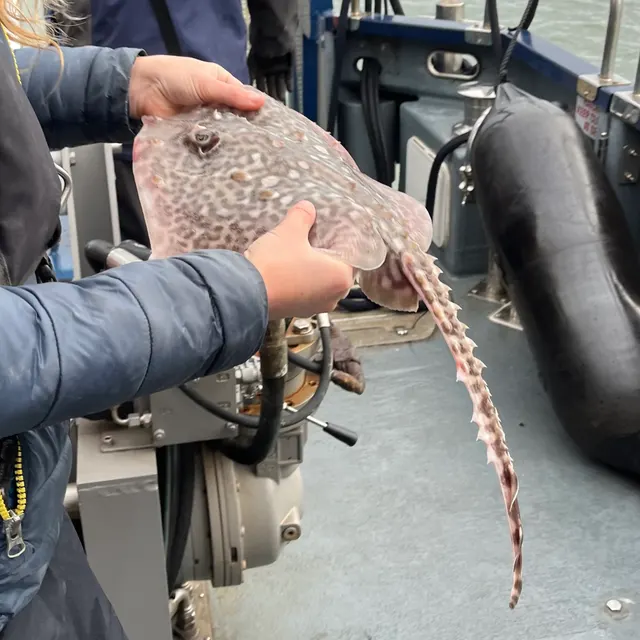 Thornback rayRegular local target1 placeCymyran and RhosneigrOver surf beach
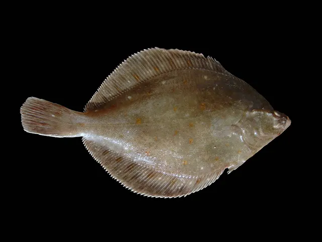 European plaiceSeasonal1 placeCymyran and RhosneigrOver surf beachAround Jun–Sept
 European sea bassSeasonal1 placeCymyran and RhosneigrOver surf beachAround Jun–Sept
What these strengths mean
- Regular local target
- Fishing sources describe this as a normal local target here, not merely as caught.
- Seasonal
- Well supported, and concentrated in part of the year rather than spread through it.
- How breadth is counted
- A fish documented at six marks is shown as six marks: breadth never raises the strength on its own. A fishery account describes the fishing; a recorded catch reports one specific catch. How evidence is weighed.
Fish documented nearby, not here
Nothing below has been documented at Cymyran and Rhosneigr itself. Each one has been documented at a named place on the same ground, and the places are listed with it. Treat this as what the water around here holds rather than as a catch list for this mark.
Widely documented on this ground
Documented at three or more neighbouring places, fished a way this place is also fished. That is a pattern about the ground rather than about any one mark, and it is the closest this site comes to saying you will probably meet a fish somewhere nothing has been written about.
From the shore
- Ballan wrasse — documented at Holyhead breakwater; Penmon Point; Moelfre rocks (+5 more)
- Atlantic mackerel — documented at Holyhead breakwater; South Stack; Trearddur Bay (+4 more)
Also documented at neighbouring places
One or two accounts each, on the ground around here. Enough to know the fish is caught in these waters; not enough to say anything about this place.
From the shore
- Atlantic cod — documented at Holyhead breakwater; Moelfre rocks
- Dab — documented at Red Wharf Bay; Moelfre rocks
- Starry smooth-hound — documented at Llanddwyn Island; Moelfre rocks
- Corkwing wrasse — documented at Moelfre rocks
- Curled octopus — documented at Moelfre rocks
- European lobster — documented at Moelfre rocks
- Turbot — documented at Red Wharf Bay
How people fish it
Practised here: Sea fishing.
Methods the sources name for this ground. Each one is explained in full on its own page.
- Surfcasting
Casting heavy baited tackle from a beach into surf — a method defined by distance, by tide, and by reading water that all looks the same.
- Ledgering
Fishing a bait on the bottom held by a weight, with no float — the simplest way to fish at distance, in depth, or in wind.
- Spinning
Casting an artificial lure and retrieving it so that it moves like something alive — the most direct form of lure fishing.
Baits and lures for these fish
The baits and lures each of the fish above is commonly taken on, from that fish’s own page. This is what works for the fish, not a report of what people use on this particular water — local knowledge and the conditions on the day still decide.
Baits
- Ragworm — for European flounder, Small-spotted catshark, European plaice, European sea bass and 1 more
- Fish strip and cut bait — for Bull huss, Conger eel, Small-spotted catshark, Thornback ray
- Sand eel — for Small-eyed ray, European sea bass, Pollack, Saithe
- Squid and cuttlefish — for Bull huss, Conger eel, Small-spotted catshark
- Crab and shellfish — for European sea bass, Saithe
- Lugworm — for European plaice, Whiting
- Peeler crab — for European flounder, European sea bass
- Sea deadbaits — for Bull huss, Small-spotted catshark
Lures
- Metal jigs — for European sea bass, Pollack, Saithe
- Soft plastics — for European sea bass, Pollack, Saithe
- Jerkbaits — for European sea bass
- Jigs and jig heads — for Pollack
- Streamers — for European sea bass
- Surface lures — for European sea bass
The ground and the water
- The ground
- Two miles of west-facing sand from Rhosneigr down to the Cymyran strait, flat rather than shelving, with rock outcrops breaking through the sand along its length. A storm beach: it needs weather to fish, and the rocks in the sand are what hold fish on it.
- Exposure
- Fully open west, and it is named as a storm beach on this coast.
Through the year
Bass in summer with plaice, flounder and pollack alongside; rays over the sand; whiting and coalfish as winter comes in.
The months the sources attach to each species here. Where a species carries no season it is listed underneath rather than assumed to run through the year.
| Species | J | F | M | A | M | J | J | A | S | O | N | D |
|---|---|---|---|---|---|---|---|---|---|---|---|---|
| Small-eyed ray — regular local target, recorded in May, June, July, August, September, October. | ||||||||||||
| European plaice — seasonal, recorded in June, July, August, September. | ||||||||||||
| European sea bass — seasonal, recorded in June, July, August, September. | ||||||||||||
| Pollack — seasonal, recorded in June, July, August, September. | ||||||||||||
| Saithe — seasonal, recorded in October, November, December, January, February, March. | ||||||||||||
| Whiting — seasonal, recorded in October, November, December, January, February, March. |
Recorded here with no season stated: Bull huss, Conger eel, European flounder, Small-spotted catshark, Thornback ray.
Safety
Tides and being cut off — Can cause serious injury or death
Tidal streams through the Menai Strait and around Anglesey's headlands reach speeds a kayak or small boat cannot make way against, with standing waves and overfalls forming at the constrictions. Slack water does not coincide with high or low tide and the window is short. Extensive intertidal flats along the strait flood rapidly and can cut off a person from behind.
What reduces it: Plan against tidal STREAM information rather than tide tables alone. Treat the Swellies as a slack-water-only proposition in any small craft. Know the exit before committing to a mark on the flats. Carry a means of calling for help and tell somebody the plan.
Worse when:
- Spring tides, when the streams are fastest and the slack window is shortest
- Wind against tide, which builds a short steep sea in minutes
- Fog or failing light, when the visual cues to what the water is doing are lost
Cliffs and rock platforms — Can cause serious injury or death
Rock marks on the north and west coasts take swell generated over a long Irish Sea fetch, and a set considerably larger than the prevailing sea can arrive without warning. Falls from wet rock and being swept from a platform are the mechanisms.
What reduces it: Watch a mark for a full set before committing to it. Wear a buoyancy aid on any rock platform. Never fish a rock mark alone in swell, and treat a forecast that mentions swell separately from wind as the one that matters.
Worse when:
- Swell arriving from a distant system in otherwise calm local conditions
- Rising tide on a platform with a single exit
- Night fishing on unfamiliar rock
Rules and access
FishingHQ does not know the current access position here. Shore angling in Wales is not rod-licensed, but access rights, landowner permission, local authority and harbour byelaws, national and inshore fisheries measures, and site designations all apply and all change. Check the current position with Natural Resources Wales, the harbour or local authority, and the landowner before going.
Who holds the answer:
- Natural Resources Wales, which administers marine and fisheries regulation in Welsh waters.
- The local authority and, where one exists, the harbour authority, for access, byelaws and shellfish classification.
- The national fisheries authority for Wales, for sea fisheries measures, licensing and enforcement.
- The inshore fisheries and conservation body for the area, for local byelaws, closed areas and gear restrictions.
- The food safety authority and the local authority, for shellfish bed classification and closures, which change continually.
- The harbour authorities and the port authority for the strait, for navigation, launching and access.
- The maritime and coastguard agency and the lifeboat service, for safety information and rescue in an area with genuine tidal hazard.
- The landowner, club or fishery, for permission to fish any freshwater on the island.
Nearby fishing
Other publicly documented places within about 40 km, by distance. Positions are approximate public geography and are never exact marks.
- Trearddur Bay — 5–10 km · Bay
- Llanddwyn Island — 10–25 km · Island
- Holyhead breakwater — 10–25 km · Breakwater
- South Stack — 10–25 km · Rock mark
- Llyn Alaw — 10–25 km · Reservoir
- Caernarfon and the Menai south entrance — 10–25 km · Tidal channel
- Dinas Dinlle — 10–25 km · Beach
- Cemaes Bay — 10–25 km · Bay
Sources for this place
- Sea Angler — Bauer Media (Specialist angling publication)Relied on for: Long-running published description of British sea angling practice by region, ground type and named mark.FishingHQ's interpretation of what it saysCitation checked — the work exists and is described correctly
- General angling website restatements of established technique — Various (Credible secondary source)Relied on for: Widely restated public descriptions of which places are conventionally fished and how, recorded as practitioner consensus rather than as scholarship, and not relied on for access, permission or any current rule.Background and mechanism onlyCitation checked — the work exists and is described correctly
- British Sea Fishing: Welsh shore marks — British Sea Fishing (Credible secondary source)Relied on for: Mark-by-mark Welsh shore angling: which species are fished for at each named mark, in which season, and with which baits and methods.States this directlyPassage read and verified
- Sea fishing in north Wales — the mark guide — Turner's Tackle (Credible secondary source)Relied on for: Ground, footing, tide state and shore species at the Anglesey and north Wales marks the retailer's own guides describe.States this directlyPassage read and verified
How FishingHQ labels evidence is explained in the evidence policy. Last reviewed 2026-08-16.