The Black Sea
Fishing regions · Last reviewed 2026-08-19
A sea that is nearly fresh at the top, permanently dead at the bottom, and fed by four of Europe's largest rivers. Almost nine tenths of its water holds no oxygen at all, so its entire fishery lives in a thin surface layer.
Being listed here is not permission to fish. What that meansClose
Access, fishing rights, seasons, licences, local bylaws and permitted methods vary and can change. Check current access, permission, local regulations, closures and restrictions before you travel or fish. FishingHQ describes what the ground is and names who holds the answer; it does not hold the answer itself.
Find the authority for a jurisdiction · What FishingHQ does and does not cover
THE BLACK SEA IS THE LARGEST BODY OF ANOXIC WATER ON EARTH, AND EVERY USEFUL THING ABOUT FISHING IT FOLLOWS FROM THAT.
It is almost enclosed. Its only connection to the world ocean is the Bosphorus, a strait about seven hundred metres wide at its narrowest — a thread compared with the basin behind it. Into that nearly closed basin drain the Danube, the Dnieper, the Dniester and the Don, along with a great many smaller rivers, delivering a volume of fresh water far larger than evaporation removes.
SO THE SURFACE IS DILUTE. Salinity in the open surface layer runs at roughly half that of the Mediterranean, and near the great river mouths it falls further still. That single fact explains most of the sea's biology: it is too fresh for a large part of the Mediterranean fauna, so its species list is short, and the species it does hold are the salt-tolerant generalists rather than the specialists.
AND THE DEPTHS ARE PERMANENTLY DEAD. Denser, saltier water enters along the bed of the Bosphorus from the Mediterranean and sits beneath the diluted surface layer. The density difference between the two is so large that they do not mix, and because they do not mix, oxygen never reaches the bottom. Below roughly 150 to 200 metres the water is anoxic and charged with hydrogen sulphide, and it has been for thousands of years. Something like eighty-seven per cent of the sea's volume holds no oxygen and no animal life.
WHICH MEANS THE ENTIRE FISHERY LIVES IN A THIN SKIN. Every fish in the Black Sea, and every fishery on it, occupies the upper hundred-odd metres and the continental shelves. There is no deep-water fishing here in any sense a Norwegian or an Atlantic angler would recognise, because there is nothing alive down there to fish for.
THE SHELF IS UNEVENLY DISTRIBUTED AND THAT DECIDES THE FISHING. The north-west, off Ukraine and Romania and shading into the very shallow Sea of Azov, is a broad shallow shelf enriched by river discharge — turbid, productive and the sea's most important nursery ground. The southern and eastern coasts, off Turkey, Georgia and the Caucasus, shelve away steeply, so deep water lies close inshore and the shore fishing is a different proposition entirely.
THE FISH ARE FEW IN SPECIES AND SOMETIMES ENORMOUS IN NUMBER. Small pelagic shoaling fish dominate: European anchovy and sprat above all, with Black Sea horse mackerel and a local shad. Above them sit bluefish, Atlantic bonito and Atlantic mackerel, which enter from the Mediterranean seasonally and are the basis of a large recreational and commercial fishery when they run. On the bottom are turbot, which is the sea's most valuable demersal fish, along with whiting, gobies and the small sea robins. Grey mullet are abundant everywhere and are the mainstay of shore fishing, because they tolerate the low salinity better than almost anything else.
What fishing here is like
A nearly enclosed brackish sea of about 436,000 square kilometres, connected to the Mediterranean only through the Bosphorus and receiving the Danube, Dnieper, Dniester and Don. Permanently stratified: a diluted, oxygenated surface layer over dense, saline, anoxic deep water charged with hydrogen sulphide below roughly 150–200 m, which leaves the great majority of its volume without animal life. Salinity in the surface layer runs at roughly half Mediterranean values and falls further near the river mouths. A broad, shallow, river-enriched shelf in the north-west shading into the very shallow Sea of Azov; steep, narrow shelves in the south and east. Bordered by Turkey, Bulgaria, Romania, Ukraine, Russia and Georgia, each administering its own fisheries.
What dominates
Shore fishing from beaches, breakwaters, harbour walls and rock, overwhelmingly for grey mullet, gobies and whiting, with float and light bottom methods dominant. Seasonal lure and feathering fishing for bluefish, Atlantic bonito and horse mackerel when they run, which is the year's main event on much of the coast and is pursued from shore and from small boats alike. Small-boat fishing over the shelf for turbot, whiting and gobies. Freshwater fishing in the lagoons, limans, deltas and lower rivers that fringe the sea, which is a large part of the region's angling and is continuous with the sea fishing rather than separate from it. Spearfishing is practised, chiefly on the clearer southern and eastern coasts, and its legality differs sharply between the bordering states.
The water available
Long sandy beaches and dune coasts, particularly in the north-west and along the Bulgarian and Romanian shore. Rocky headlands and cliffs on the southern Turkish and eastern Caucasian coasts, where deep water lies close in. Extensive brackish lagoons and limans — drowned river valleys cut off by sand bars — which are among the most productive and most distinctive habitats in the basin. The Danube Delta and other river mouths, where salinity falls to nearly nothing and freshwater and marine species overlap. The very shallow, warm, almost fresh Sea of Azov in the north-east, connected through the Kerch Strait. Seagrass and mussel beds on the shelf. And below all of it, the permanently anoxic deep, which holds nothing.
How the rules are structured
Six countries border this sea — Turkey, Bulgaria, Romania, Ukraine, Russia and Georgia — and each administers recreational fishing separately. Two of them are European Union member states and four are not, so the framework a visitor meets differs at the border in kind and not only in detail. Licensing, size limits, bag limits, closed seasons, permitted methods and the position on spearfishing all vary between them, and several have specific and strict provisions for sturgeon that reflect the conservation position. A regional fisheries commission co-ordinates on shared stocks and does not issue recreational permissions. Nothing about one country's arrangement may be assumed to hold in the next, and the authority for the coast being fished is the only source for its rules. FishingHQ does not state what any current rule is, in any of the six.
Who to ask
- Six national fisheries authorities, one per bordering state — Turkey, Bulgaria, Romania, Ukraine, Russia and Georgia — each issuing its own recreational permissions on its own terms.
- A regional fisheries commission co-ordinating on shared stocks across the basin. It does not issue recreational permissions and is not the body to ask about a licence.
- Protected-area administrations, which along this coast are extensive and frequently cover the most productive water. The Danube Delta's reserve authority is the largest and administers access separately from the general fisheries administration.
- Lagoon, liman and inland water managers, which in several countries hold the terms actually governing a particular water beneath the national permission.
- The international controls on trade in sturgeon products, which sit above all six national regimes and are administered separately from fishing rules.
Words you will meet
- Liman
- A brackish coastal lagoon formed where a river valley has been drowned and then closed off by a sand bar. Used around the whole northern coast, and it names the basin's most characteristic and most productive habitat.
- Lufer
- Bluefish in Turkish. The fish carries a recognised sequence of different names by size class rather than one name, which is a distinct local vocabulary rather than a translation.
- Palamut
- Atlantic bonito in Turkish. Its autumn run is a seasonal event of considerable cultural weight on the Bosphorus and the southern coast.
- Kefal
- Grey mullet, in related forms across several of the region's languages. The commonest shore species in the basin, because it tolerates the low salinity better than almost anything else.
- Hamsi
- European anchovy in Turkish. The single most important fish in the basin by volume and the centre of a whole regional food culture on the Turkish Black Sea coast.
Conditions and hazards
This is a comparatively benign sea to fish and it has specific hazards a visitor will not expect. Tides are negligible, which removes the cut-off risk that dominates Atlantic shore fishing and simultaneously removes the tidal flush that keeps enclosed water clean — so water quality near river mouths and in closed lagoons is a swimming and shellfish question rather than a tidal one. The sea is small enough that severe storms build steep, short, dangerous seas very quickly, particularly on the exposed north-western coast in winter, and small-boat conditions deteriorate faster than the fetch would suggest. Summer heat and sun on unshaded beaches and breakwaters are a real fatigue and dehydration risk. Water quality after heavy rainfall in the great river catchments can be poor for a considerable distance offshore, which bears on both immersion and on anything gathered to eat. Several bordering coasts carry military, border or navigation restrictions, and some sections of coast are subject to access controls that have nothing to do with fisheries. And the region has been directly affected by armed conflict: parts of the northern and north-western coast and the Sea of Azov carry hazards, access prohibitions and navigational dangers that no fishing source is the right authority for.
A sea comprehensively rebuilt within living memory
The description above sets out how this sea is arranged. It does not convey how much of that arrangement is recent, and a reader working from an older account of the Black Sea will be working from a description of a different ecosystem.
THE MIGRATORY FISH ARE THE GRIEF, AND THEY ARE THE PART THAT HAS NOT RECOVERED. Six sturgeon species ran from this sea into the Danube, the Dnieper and the other great rivers — beluga among them, historically the largest fish entering fresh water anywhere in Europe. Dams cut the migrations, the Iron Gates barrages on the Danube above all, and a fishery driven substantially by the caviar trade removed most of what the dams had left. All of these species now sit at the highest levels of extinction risk and several are functionally gone from most of their former rivers. Nothing else in European fishing is at this stage of collapse, and the illegal trade has not stopped.
EUTROPHICATION KILLED LARGE AREAS OF THE SHELF. The catchment draining into this sea covers roughly a third of continental Europe, and through the later twentieth century agricultural nutrient loading down the Danube and the other great rivers drove severe eutrophication on the north-western shelf. Oxygen depletion reached up out of the deep and onto the shelf itself, and bottom communities over very large areas died. That is the mechanism behind this sea's mass mortality events and it is a shallow-water phenomenon rather than a deep one.
AN INTRODUCED COMB JELLY THEN COLLAPSED THE PELAGIC FISHERY. Mnemiopsis leidyi, a ctenophore native to the western Atlantic, arrived in ballast water in the 1980s, encountered a system already destabilised by eutrophication and a food web with nothing to control it, and reached biomasses without precedent. It ate fish eggs, fish larvae and the zooplankton the small pelagics depended on. The anchovy fishery — the largest fishery in the basin — collapsed.
AND SOME OF IT HAS COME BACK, WHICH IS THE PART MOST ACCOUNTS OMIT. Nutrient loading fell sharply after the economic changes of the 1990s reduced fertiliser use across the catchment, and a second introduced comb jelly, Beroe ovata, arrived and ate the first. The north-western shelf has partially recovered and the anchovy stock has substantially rebuilt. This is simultaneously one of the best-documented ecosystem collapses anywhere and one of the few well-documented partial recoveries.
WHICH IS WHY THIS PAGE IS CAUTIOUS ABOUT ITS OWN CURRENCY. A sea that changed this much in forty years is a sea where a description ages fast, and the standing advice for a reader is to treat any account of Black Sea fish abundance — including this one — as a snapshot rather than as a stable fact.
Backed by research — why, and the sources (3)
Supported by peer-reviewed research or fisheries science. The sources are listed and can be checked.
- The European Environment Agency's assessments of Europe's waters, seas and coasts — European Environment Agency, Copenhagen (Conservation authority)Relied on for: State-of-the-environment assessment of Europe's seas including the Black Sea: eutrophication, nutrient loading from the Danube and other large rivers, water body status and the designation of marine protected sites.States this directlyCitation checked — the work exists and is described correctly
- The IUCN Red List of Threatened Species — International Union for Conservation of Nature (Conservation authority)Relied on for: Conservation assessments of the sturgeons of the Black Sea and Danube basin and of other species named, and the basis for the extinction-risk statements made.States this directlyCitation checked — the work exists and is described correctly
- FishBase: a global information system on fishes — Froese, R. and D. Pauly, eds. — FishBase Consortium (Scientific institute)Relied on for: Recorded environment, depth range, salinity tolerance, distribution and biology of the species named.States this directlyPassage read and verified
What the stratification means if you are holding a rod
The anoxic deep is usually presented as an oceanographic curiosity. It has direct, practical consequences for fishing and they are worth stating plainly.
THERE IS NO DEEP FISHING AND NO DEEP REFUGE. In most seas, fish move deeper to escape summer heat, winter cold or rough weather. Here they cannot: below the oxygen boundary there is nothing to move into. So the fish are compressed into the surface layer and the shelf all year, which concentrates them and makes them more available and more vulnerable at the same time.
WHICH MAKES THE SHELF EDGE A HARD WALL RATHER THAN A GRADIENT. On the steep southern and eastern coasts the shelf is narrow and the bottom drops past the oxygen boundary close inshore. Fishing there is fishing a strip. On the broad north-western shelf the whole seabed lies within the living layer, which is why that area carries the sea's nursery grounds and most of its bottom fishery.
THE BOUNDARY MOVES, AND IT MOVES IN THE WRONG DIRECTION WHEN IT MATTERS. The depth of the oxygen limit is not fixed: it responds to river discharge, to wind-driven mixing and to nutrient loading, and during the worst eutrophication of the late twentieth century oxygen depletion reached up onto the north-western shelf itself and killed bottom life over very large areas. That is the mechanism behind this sea's mass mortality events, and it is a shallow-water phenomenon rather than a deep one.
STRATIFICATION ALSO EXPLAINS THE SEASONAL FISHERY. The surface layer warms strongly in summer and forms its own thermocline within the living zone, and the pelagic fish move with it. The autumn cooling that breaks that summer layer coincides with the migratory runs of bluefish and bonito, which is why autumn is the season on most of this coast.
AND IT EXPLAINS WHY THE SPECIES LIST IS SHORT. Low salinity excludes much of the Mediterranean fauna; the anoxic deep excludes everything that would live below 200 m anywhere else. A sea missing both its stenohaline species and its entire deep-water community is a sea with comparatively few kinds of fish in it, in sometimes extraordinary numbers.
Backed by research — why, and the sources (3)
Supported by peer-reviewed research or fisheries science. The sources are listed and can be checked.
- EMODnet — the European Marine Observation and Data Network — The European Commission, assembled from the national hydrographic offices, geological surveys and marine institutes of the member states (Scientific institute)Relied on for: Bathymetry, salinity, physical oceanography and habitat data for European sea basins including the Black Sea.States this directlyCitation checked — the work exists and is described correctly
- The European Environment Agency's assessments of Europe's waters, seas and coasts — European Environment Agency, Copenhagen (Conservation authority)Relied on for: State-of-the-environment assessment of Europe's seas including the Black Sea: eutrophication, nutrient loading from the Danube and other large rivers, water body status and the designation of marine protected sites.States this directlyCitation checked — the work exists and is described correctly
- FishBase: a global information system on fishes — Froese, R. and D. Pauly, eds. — FishBase Consortium (Scientific institute)Relied on for: Recorded environment, depth range, salinity tolerance, distribution and biology of the species named.States this directlyPassage read and verified
The freshwater and the sea are one fishery here, which is unusual
Most of FishingHQ can treat sea fishing and freshwater fishing as separate activities that happen to occur near each other. Around the Black Sea that separation breaks down, and a reader who imports it will misread the whole region.
THE SALINITY GRADIENT IS LONG AND GENTLE. An open-sea salinity already only half that of the Mediterranean falls through the coastal zone, falls further in the limans, and reaches nearly nothing in the deltas and river mouths. There is no sharp line where the sea stops. There is a broad zone in which marine, brackish and freshwater species overlap, and the same water may be brackish in one season and nearly fresh in another according to river discharge.
SO THE SAME DAY'S FISHING CAN CROSS THE BOUNDARY. Pike, zander, perch, carp and bream are caught in lagoons and river mouths that also hold grey mullet, gobies and flounder. A liman may be fished as fresh water for one species and salt for another, and which it is depends on where in it you are standing and what the river has been doing.
WHICH MAKES THE MIGRATORY FISH CENTRAL RATHER THAN EXOTIC. Sturgeon, shad and several other species built their whole life histories on this gradient, running between the sea and the rivers. They are the fish that suffered most when dams cut the rivers, precisely because they needed both halves and the connection between them.
AND IT MAKES THE ADMINISTRATIVE QUESTION HARDER THAN IT LOOKS. Several bordering countries administer sea and inland fishing under different arrangements, or apply different rules to a lagoon than to the open coast, and the physical boundary between the two is genuinely ambiguous. A reader who has established their position for the sea has not necessarily established it for the liman behind the beach, and that is a question for the authority rather than a matter of inference.
Backed by research — why, and the sources (3)
Supported by peer-reviewed research or fisheries science. The sources are listed and can be checked.
- FAO Species Identification Guides for Fishery Purposes and the FAO Species Catalogues — Food and Agriculture Organization of the United Nations (Scientific institute)Relied on for: Distribution, habitat association and biology of the fishes of the Mediterranean and Black Sea, from the regional identification guides prepared for fishery purposes.States this directlyCitation checked — the work exists and is described correctly
- FishBase: a global information system on fishes — Froese, R. and D. Pauly, eds. — FishBase Consortium (Scientific institute)Relied on for: Recorded environment, depth range, salinity tolerance, distribution and biology of the species named.States this directlyPassage read and verified
- The European Environment Agency's assessments of Europe's waters, seas and coasts — European Environment Agency, Copenhagen (Conservation authority)Relied on for: State-of-the-environment assessment of Europe's seas including the Black Sea: eutrophication, nutrient loading from the Danube and other large rivers, water body status and the designation of marine protected sites.States this directlyCitation checked — the work exists and is described correctly
Six countries, six answers, and one thing worth checking before anything else
This page deliberately states no rule, and the reason is that there is no such thing as a Black Sea rule. Six sovereign states border it, two are in the European Union and four are not, and the differences between them are structural rather than marginal.
WHAT VARIES IS NOT ONLY THE NUMBERS. Whether a recreational licence is needed at all, whether sea and inland fishing are covered by one document or two, what may be taken and in what quantity, which seasons are closed, and whether spearfishing is permitted, restricted or prohibited — all of these differ between neighbours here, and the spearfishing position differs most sharply of all.
THE ONE THING TO ESTABLISH FIRST IS THE STURGEON POSITION. Every sturgeon species in this basin is at a high level of extinction risk and several are functionally extinct across most of their former range. The bordering states have responded with strict and specific measures, and the international trade in their products is separately controlled. The practical consequence for an angler is that these are not fish to be treated as a catch, that an incidentally caught sturgeon has a required handling and reporting procedure in several jurisdictions, and that the rules here have changed repeatedly. FishingHQ states none of them.
PROTECTED AREAS ARE EXTENSIVE AND THEY ARE WHERE THE FISHING IS GOOD. The Danube Delta is a World Heritage property and a biosphere reserve with its own authority; large parts of the north-western shelf and many lagoons carry designations; and a designation does not automatically prohibit angling but frequently modifies it. The productive water and the protected water are substantially the same water.
AND THE PATTERN TO EXPECT IS NATIONAL PLUS LOCAL. Most of these countries have a national fisheries authority that issues the headline permission, and a layer beneath it — a reserve administration, a regional body, a lagoon manager — that sets the terms actually governing a particular water. Resolving the first has not resolved the second, which is the same trap `jurisdiction-romania` describes for the Delta.
Official guidance — why, and the sources (3)
Stated by a fisheries authority, scientific institute or recognised angling body. Authoritative, but summarising rather than demonstrating.
- The European Environment Agency's assessments of Europe's waters, seas and coasts — European Environment Agency, Copenhagen (Conservation authority)Relied on for: State-of-the-environment assessment of Europe's seas including the Black Sea: eutrophication, nutrient loading from the Danube and other large rivers, water body status and the designation of marine protected sites.States this directlyCitation checked — the work exists and is described correctly
- The IUCN Red List of Threatened Species — International Union for Conservation of Nature (Conservation authority)Relied on for: Conservation assessments of the sturgeons of the Black Sea and Danube basin and of other species named, and the basis for the extinction-risk statements made.States this directlyCitation checked — the work exists and is described correctly
- FAO Species Identification Guides for Fishery Purposes and the FAO Species Catalogues — Food and Agriculture Organization of the United Nations (Scientific institute)Relied on for: Distribution, habitat association and biology of the fishes of the Mediterranean and Black Sea, from the regional identification guides prepared for fishery purposes.States this directlyCitation checked — the work exists and is described correctly
Some of what lives here
Fish recorded here that FishingHQ holds a reviewed photograph of. It is not a complete list of what The Black Sea holds, and it is not a prediction that you will catch any of them — it is a way in to the ones we can show you.
 Thick-lipped grey mulletA shoaling coastal fish that eats algae and detritus rather than prey — which makes it the hardest common sea fish to catch and the most interesting to think about.
Diego Delso — CC BY-SA 4.0, via Wikimedia Commons
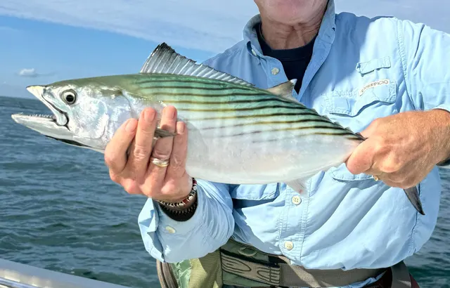 Atlantic bonitoA small, fast, striped tuna relative that arrives on temperate coasts in shoals each year and is the most accessible member of the family to a shore angler.
ricofish — CC0, via Wikimedia Commons
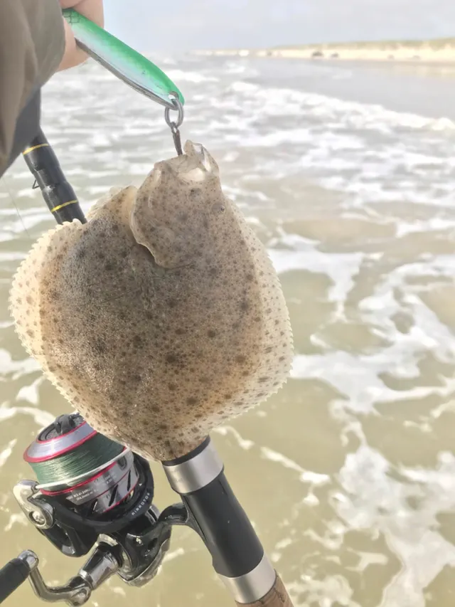 TurbotA large, almost circular left-eyed flatfish with bony tubercles instead of scales, the most valuable flatfish in European waters.
Jonas Holm Hald Therkildsen — CC0, via iNaturalist
 Atlantic mackerelA fast, schooling, obligate-swimming pelagic fish that arrives inshore in summer in enormous numbers, and the species most sea anglers catch first.
Hans Hillewaert — CC BY-SA 4.0, via Wikimedia Commons
 European flounderThe flatfish that runs up rivers — a tolerant, estuarine right-eyed flounder with bony tubercles along its fin bases and a habit of turning up in fresh water.
nbasargin — CC BY, via iNaturalist
Check the rules before you fish
Fishing laws, bylaws, access rules, seasons, bait restrictions and permitted methods vary by location and can change. Check the current rules from the relevant authority and the water you intend to fish before fishing.
Check with:
- Current national or regional law for where you are fishing
- Current local bylaws
- The relevant fisheries authority
- The landowner, club or fishery whose water it is
- Any restrictions specific to the species or the method you intend to use
Where to go next
What swims here
- Atlantic bonitoA seasonal visitor rather than a resident, entering from the Mediterranean through the Bosphorus and running along the coast in autumn. That run is the year's main fishing event on much of the southern coast and carries real cultural weight.
- Atlantic mackerelEnters seasonally from the Mediterranean rather than being resident, which is characteristic of the basin's larger pelagic fish generally — the sea is too dilute for many of them to complete a life cycle in.
- Beluga sturgeonThe sea half of an anadromous life history that no longer completes. Beluga live here and ran into the Danube, the Dnieper and the other great rivers to spawn; the dams cut the river half, and what remains is a marine population that mostly cannot reproduce where it evolved to.
- BluefishThe other half of the autumn run, and the fish whose Turkish names change through a recognised sequence as it grows — a local vocabulary that exists because the fish matters enough to need one.
- European anchovyThe most important fish in the basin by volume and the centre of a whole regional food culture on the Turkish coast. Its collapse under the introduced comb jelly in the 1980s and its subsequent partial recovery is the best-documented sequence of its kind anywhere.
- European flounderA flatfish that tolerates very low salinity and runs well up into the lagoons and river mouths, which is why it turns up in water an angler would not think of as sea at all.
- European spratOne of the two small pelagic shoaling fish the basin's whole food web rests on, occupying the cold intermediate layer within the thin living zone.
- Thick-lipped grey mulletThe mainstay of shore fishing across the whole basin, and it is there because of the salinity. Mullet tolerate dilute and brackish water better than almost any other marine fish, which is exactly what a sea at half Mediterranean salinity with enormous river inputs selects for.
1 more
- Turbot Fish
How people fish here
Local knowledge
- Catadromy, anadromy, and crossing the salinity lineA basin where that record's boundary is a broad zone rather than a line. Surface salinity is already only half the Mediterranean's, falls further through the coastal lagoons, and reaches nearly nothing in the deltas — so marine, brackish and freshwater species overlap across tens of kilometres, and the migratory fish that built their life histories on that gradient are the ones that suffered most when the rivers were dammed.
- Dissolved oxygen and fishThe most extreme case of that record's subject anywhere on earth. Permanent density stratification means the deep water never mixes with the surface, so oxygen never reaches it — and roughly eighty-seven per cent of this sea's volume has held none for thousands of years. Every fish and every fishery is compressed into the thin oxygenated skin above it, which is the single fact that explains the sea's biology.
- Turbidity and visibilityA sea whose north-western shelf is turbid by construction rather than by weather, because four of Europe's largest rivers discharge into a nearly enclosed basin. That is what makes the shelf productive, what makes it the basin's nursery ground, and what makes sight-dependent fishing methods less useful there than on the clearer southern and eastern coasts.
- Why fish migrateThe basin where the answer to that question was cut. Sturgeon, shad and other species ran between this sea and the rivers draining a third of continental Europe; the Iron Gates barrages and the other dams ended most of it. A migration is a behaviour that depends on a route existing, and this is the clearest European case of what happens when the route is removed.
How this compares
- BulgariaThat page says: "It is described properly in the Black Sea record, and the headline is that this is a low-salinity, stratified sea whose deep water is permanently without oxygen, so its entire fishery lives in a thin surface layer." It was pointing at a page that did not exist. This is it.
- Coastal lagoonsThe habitat this sea is fringed with and which its own regional vocabulary names — a liman is a drowned river valley closed off by a sand bar, and the northern coast is lined with them. They are the basin's most productive habitat and the place where its sea fishing and its freshwater fishing genuinely become one activity rather than two that happen nearby.
- RomaniaThat page says of its coast: "It is a genuinely different sea and it is described in its own record." This is that record. Romania's frontage is short, sandy, shallow and so strongly diluted by the Danube's discharge that it is one of the least marine stretches of coast in Europe — which only makes sense read against the basin's stratification and its salinity.
- The Baltic SeaThe instructive comparison, because they are the same kind of sea with one difference that changes everything. Both are nearly enclosed, both are strongly diluted by river inflow, both stratify, and both have deep water that loses its oxygen. The Baltic's stratification is weaker and its deep water is intermittently and increasingly anoxic; the Black Sea's is permanent and has been for millennia. A reader who understands one is most of the way to understanding the other, and the Baltic is what the Black Sea would look like earlier in the same process.
- The Danube basinThe two halves of one system, and the reason either is comprehensible. The Danube delivers the fresh water that dilutes the sea, the nutrients that eutrophied its shelf and the migratory fish that ran between them — and the sea is where those fish spent most of their lives. The basin record ends at the mouth and says the migratory species 'once ran' there; this is the water they ran into.
Environment and conservation
- Invasive species and biosecurityOne of the best-documented invasion sequences anywhere. The comb jelly Mnemiopsis leidyi arrived in ballast water in the 1980s, met a food web already destabilised by eutrophication and with nothing to control it, ate fish eggs, larvae and the zooplankton the small pelagics fed on, and the anchovy fishery collapsed. A second introduced comb jelly then arrived and ate the first, and the stock has substantially rebuilt — which makes this a rare documented case of both the collapse and a partial recovery.
- Marine protected areas and spearfishingA basin where the productive water and the protected water are substantially the same water. The Danube Delta is a World Heritage property and a biosphere reserve with its own administering authority, and large parts of the north-western shelf and many lagoons carry designations. A designation does not automatically prohibit angling and frequently modifies it, and resolving the national permission has not resolved the reserve's.
Sources and evidence
- EMODnet — the European Marine Observation and Data Network — The European Commission, assembled from the national hydrographic offices, geological surveys and marine institutes of the member states (Scientific institute)Relied on for: Bathymetry, salinity, physical oceanography and habitat data for European sea basins including the Black Sea.States this directlyCitation checked — the work exists and is described correctly
- The European Environment Agency's assessments of Europe's waters, seas and coasts — European Environment Agency, Copenhagen (Conservation authority)Relied on for: State-of-the-environment assessment of Europe's seas including the Black Sea: eutrophication, nutrient loading from the Danube and other large rivers, water body status and the designation of marine protected sites.States this directlyCitation checked — the work exists and is described correctly
- FAO Species Identification Guides for Fishery Purposes and the FAO Species Catalogues — Food and Agriculture Organization of the United Nations (Scientific institute)Relied on for: Distribution, habitat association and biology of the fishes of the Mediterranean and Black Sea, from the regional identification guides prepared for fishery purposes.States this directlyCitation checked — the work exists and is described correctly
- FishBase: a global information system on fishes — Froese, R. and D. Pauly, eds. — FishBase Consortium (Scientific institute)Relied on for: Recorded environment, depth range, salinity tolerance, distribution and biology of the species named.States this directlyPassage read and verified
- The IUCN Red List of Threatened Species — International Union for Conservation of Nature (Conservation authority)Relied on for: Conservation assessments of the sturgeons of the Black Sea and Danube basin and of other species named, and the basis for the extinction-risk statements made.States this directlyCitation checked — the work exists and is described correctly
Why the 21 connections on this page are here, and the sources
What swims here
Backed by research — 9 connections
Supported by peer-reviewed research or fisheries science. The sources are listed and can be checked.
Atlantic bonito
A distribution edge resting on published identification and distribution references rather than on angling report, written where the species is genuinely characteristic of the system rather than merely recorded in it once.
- FishBase: a global information system on fishes — Froese, R. and D. Pauly, eds. — FishBase Consortium (Scientific institute)Relied on for: Recorded environment, salinity tolerance, depth range, distribution and biology of the species named.States this directlyPassage read and verified
- FAO Species Identification Guides for Fishery Purposes and the FAO Species Catalogues — Food and Agriculture Organization of the United Nations (Scientific institute)Relied on for: Distribution, habitat association and identification of the fishes of the Mediterranean and Black Sea region.States this directlyCitation checked — the work exists and is described correctly
Atlantic mackerel
A distribution edge resting on published identification and distribution references rather than on angling report, written where the species is genuinely characteristic of the system rather than merely recorded in it once.
- FishBase: a global information system on fishes — Froese, R. and D. Pauly, eds. — FishBase Consortium (Scientific institute)Relied on for: Recorded environment, salinity tolerance, depth range, distribution and biology of the species named.States this directlyPassage read and verified
- FAO Species Identification Guides for Fishery Purposes and the FAO Species Catalogues — Food and Agriculture Organization of the United Nations (Scientific institute)Relied on for: Distribution, habitat association and identification of the fishes of the Mediterranean and Black Sea region.States this directlyCitation checked — the work exists and is described correctly
Beluga sturgeon
A distribution edge resting on published identification and distribution references rather than on angling report, written where the species is genuinely characteristic of the system rather than merely recorded in it once.
- FishBase: a global information system on fishes — Froese, R. and D. Pauly, eds. — FishBase Consortium (Scientific institute)Relied on for: Recorded environment, salinity tolerance, depth range, distribution and biology of the species named.States this directlyPassage read and verified
- FAO Species Identification Guides for Fishery Purposes and the FAO Species Catalogues — Food and Agriculture Organization of the United Nations (Scientific institute)Relied on for: Distribution, habitat association and identification of the fishes of the Mediterranean and Black Sea region.States this directlyCitation checked — the work exists and is described correctly
Bluefish
A distribution edge resting on published identification and distribution references rather than on angling report, written where the species is genuinely characteristic of the system rather than merely recorded in it once.
- FishBase: a global information system on fishes — Froese, R. and D. Pauly, eds. — FishBase Consortium (Scientific institute)Relied on for: Recorded environment, salinity tolerance, depth range, distribution and biology of the species named.States this directlyPassage read and verified
- FAO Species Identification Guides for Fishery Purposes and the FAO Species Catalogues — Food and Agriculture Organization of the United Nations (Scientific institute)Relied on for: Distribution, habitat association and identification of the fishes of the Mediterranean and Black Sea region.States this directlyCitation checked — the work exists and is described correctly
European anchovy
A distribution edge resting on published identification and distribution references rather than on angling report, written where the species is genuinely characteristic of the system rather than merely recorded in it once.
- FishBase: a global information system on fishes — Froese, R. and D. Pauly, eds. — FishBase Consortium (Scientific institute)Relied on for: Recorded environment, salinity tolerance, depth range, distribution and biology of the species named.States this directlyPassage read and verified
- FAO Species Identification Guides for Fishery Purposes and the FAO Species Catalogues — Food and Agriculture Organization of the United Nations (Scientific institute)Relied on for: Distribution, habitat association and identification of the fishes of the Mediterranean and Black Sea region.States this directlyCitation checked — the work exists and is described correctly
European flounder
A distribution edge resting on published identification and distribution references rather than on angling report, written where the species is genuinely characteristic of the system rather than merely recorded in it once.
- FishBase: a global information system on fishes — Froese, R. and D. Pauly, eds. — FishBase Consortium (Scientific institute)Relied on for: Recorded environment, salinity tolerance, depth range, distribution and biology of the species named.States this directlyPassage read and verified
- FAO Species Identification Guides for Fishery Purposes and the FAO Species Catalogues — Food and Agriculture Organization of the United Nations (Scientific institute)Relied on for: Distribution, habitat association and identification of the fishes of the Mediterranean and Black Sea region.States this directlyCitation checked — the work exists and is described correctly
European sprat
A distribution edge resting on published identification and distribution references rather than on angling report, written where the species is genuinely characteristic of the system rather than merely recorded in it once.
- FishBase: a global information system on fishes — Froese, R. and D. Pauly, eds. — FishBase Consortium (Scientific institute)Relied on for: Recorded environment, salinity tolerance, depth range, distribution and biology of the species named.States this directlyPassage read and verified
- FAO Species Identification Guides for Fishery Purposes and the FAO Species Catalogues — Food and Agriculture Organization of the United Nations (Scientific institute)Relied on for: Distribution, habitat association and identification of the fishes of the Mediterranean and Black Sea region.States this directlyCitation checked — the work exists and is described correctly
Thick-lipped grey mullet
A distribution edge resting on published identification and distribution references rather than on angling report, written where the species is genuinely characteristic of the system rather than merely recorded in it once.
- FishBase: a global information system on fishes — Froese, R. and D. Pauly, eds. — FishBase Consortium (Scientific institute)Relied on for: Recorded environment, salinity tolerance, depth range, distribution and biology of the species named.States this directlyPassage read and verified
- FAO Species Identification Guides for Fishery Purposes and the FAO Species Catalogues — Food and Agriculture Organization of the United Nations (Scientific institute)Relied on for: Distribution, habitat association and identification of the fishes of the Mediterranean and Black Sea region.States this directlyCitation checked — the work exists and is described correctly
Turbot
A distribution edge resting on published identification and distribution references rather than on angling report, written where the species is genuinely characteristic of the system rather than merely recorded in it once.
- FishBase: a global information system on fishes — Froese, R. and D. Pauly, eds. — FishBase Consortium (Scientific institute)Relied on for: Recorded environment, salinity tolerance, depth range, distribution and biology of the species named.States this directlyPassage read and verified
- FAO Species Identification Guides for Fishery Purposes and the FAO Species Catalogues — Food and Agriculture Organization of the United Nations (Scientific institute)Relied on for: Distribution, habitat association and identification of the fishes of the Mediterranean and Black Sea region.States this directlyCitation checked — the work exists and is described correctly
How people fish here
What experienced anglers do — 1 connection
Widely and independently recommended by experienced anglers and specialist sources. This is real angling knowledge, not proof: controlled evidence for it is limited, and FishingHQ records it as convention rather than as a demonstrated effect.
Sea fishing
The discipline edge every sea region carries, written with the qualification that this basin genuinely strains the category.
- EMODnet — the European Marine Observation and Data Network — The European Commission, assembled from the national hydrographic offices, geological surveys and marine institutes of the member states (Scientific institute)Relied on for: Bathymetry, salinity and physical oceanography of European sea basins including the Black Sea.States this directlyCitation checked — the work exists and is described correctly
- The European Environment Agency's assessments of Europe's waters, seas and coasts — European Environment Agency, Copenhagen (Conservation authority)Relied on for: State-of-the-environment assessment of Europe's seas and surface waters, including eutrophication, nutrient loading and river continuity in the Danube and Black Sea catchment.States this directlyCitation checked — the work exists and is described correctly
Local knowledge
Backed by research — 4 connections
Supported by peer-reviewed research or fisheries science. The sources are listed and can be checked.
Catadromy, anadromy, and crossing the salinity line
A place or a fish joined to the mechanism that explains it, written where the subject is a worked example of that mechanism rather than merely subject to it.
- EMODnet — the European Marine Observation and Data Network — The European Commission, assembled from the national hydrographic offices, geological surveys and marine institutes of the member states (Scientific institute)Relied on for: Bathymetry, salinity and physical oceanography of European sea basins including the Black Sea.States this directlyCitation checked — the work exists and is described correctly
- The European Environment Agency's assessments of Europe's waters, seas and coasts — European Environment Agency, Copenhagen (Conservation authority)Relied on for: State-of-the-environment assessment of Europe's seas and surface waters, including eutrophication, nutrient loading and river continuity in the Danube and Black Sea catchment.States this directlyCitation checked — the work exists and is described correctly
Dissolved oxygen and fish
A place or a fish joined to the mechanism that explains it, written where the subject is a worked example of that mechanism rather than merely subject to it.
- EMODnet — the European Marine Observation and Data Network — The European Commission, assembled from the national hydrographic offices, geological surveys and marine institutes of the member states (Scientific institute)Relied on for: Bathymetry, salinity and physical oceanography of European sea basins including the Black Sea.States this directlyCitation checked — the work exists and is described correctly
- The European Environment Agency's assessments of Europe's waters, seas and coasts — European Environment Agency, Copenhagen (Conservation authority)Relied on for: State-of-the-environment assessment of Europe's seas and surface waters, including eutrophication, nutrient loading and river continuity in the Danube and Black Sea catchment.States this directlyCitation checked — the work exists and is described correctly
Turbidity and visibility
A place or a fish joined to the mechanism that explains it, written where the subject is a worked example of that mechanism rather than merely subject to it.
- EMODnet — the European Marine Observation and Data Network — The European Commission, assembled from the national hydrographic offices, geological surveys and marine institutes of the member states (Scientific institute)Relied on for: Bathymetry, salinity and physical oceanography of European sea basins including the Black Sea.States this directlyCitation checked — the work exists and is described correctly
- The European Environment Agency's assessments of Europe's waters, seas and coasts — European Environment Agency, Copenhagen (Conservation authority)Relied on for: State-of-the-environment assessment of Europe's seas and surface waters, including eutrophication, nutrient loading and river continuity in the Danube and Black Sea catchment.States this directlyCitation checked — the work exists and is described correctly
Why fish migrate
A place or a fish joined to the mechanism that explains it, written where the subject is a worked example of that mechanism rather than merely subject to it.
- The IUCN Red List of Threatened Species — International Union for Conservation of Nature (Conservation authority)Relied on for: Conservation assessments of the sturgeons of the Black Sea and Danube basin, the threats recorded against them, and the basis for the extinction-risk statements made.States this directlyCitation checked — the work exists and is described correctly
- The European Environment Agency's assessments of Europe's waters, seas and coasts — European Environment Agency, Copenhagen (Conservation authority)Relied on for: Assessment of river continuity, barriers to migration and hydromorphological pressure in the Danube basin.States this directlyCitation checked — the work exists and is described correctly
How this compares
Backed by research — 5 connections
Supported by peer-reviewed research or fisheries science. The sources are listed and can be checked.
Bulgaria
A comparison written where a reader genuinely needs the two set side by side — either because they confuse them, or because the difference between them is the thing worth knowing.
- EMODnet — the European Marine Observation and Data Network — The European Commission, assembled from the national hydrographic offices, geological surveys and marine institutes of the member states (Scientific institute)Relied on for: Bathymetry, salinity and physical oceanography of European sea basins including the Black Sea.States this directlyCitation checked — the work exists and is described correctly
- The European Environment Agency's assessments of Europe's waters, seas and coasts — European Environment Agency, Copenhagen (Conservation authority)Relied on for: State-of-the-environment assessment of Europe's seas and surface waters, including eutrophication, nutrient loading and river continuity in the Danube and Black Sea catchment.States this directlyCitation checked — the work exists and is described correctly
Coastal lagoons
A comparison written where a reader genuinely needs the two set side by side — either because they confuse them, or because the difference between them is the thing worth knowing.
- EMODnet — the European Marine Observation and Data Network — The European Commission, assembled from the national hydrographic offices, geological surveys and marine institutes of the member states (Scientific institute)Relied on for: Bathymetry, salinity and physical oceanography of European sea basins including the Black Sea.States this directlyCitation checked — the work exists and is described correctly
- The European Environment Agency's assessments of Europe's waters, seas and coasts — European Environment Agency, Copenhagen (Conservation authority)Relied on for: State-of-the-environment assessment of Europe's seas and surface waters, including eutrophication, nutrient loading and river continuity in the Danube and Black Sea catchment.States this directlyCitation checked — the work exists and is described correctly
Romania
A comparison written where a reader genuinely needs the two set side by side — either because they confuse them, or because the difference between them is the thing worth knowing.
- EMODnet — the European Marine Observation and Data Network — The European Commission, assembled from the national hydrographic offices, geological surveys and marine institutes of the member states (Scientific institute)Relied on for: Bathymetry, salinity and physical oceanography of European sea basins including the Black Sea.States this directlyCitation checked — the work exists and is described correctly
- The European Environment Agency's assessments of Europe's waters, seas and coasts — European Environment Agency, Copenhagen (Conservation authority)Relied on for: State-of-the-environment assessment of Europe's seas and surface waters, including eutrophication, nutrient loading and river continuity in the Danube and Black Sea catchment.States this directlyCitation checked — the work exists and is described correctly
The Baltic Sea
A comparison written where a reader genuinely needs the two set side by side — either because they confuse them, or because the difference between them is the thing worth knowing.
- EMODnet — the European Marine Observation and Data Network — The European Commission, assembled from the national hydrographic offices, geological surveys and marine institutes of the member states (Scientific institute)Relied on for: Bathymetry, salinity and physical oceanography of European sea basins including the Black Sea.States this directlyCitation checked — the work exists and is described correctly
- The European Environment Agency's assessments of Europe's waters, seas and coasts — European Environment Agency, Copenhagen (Conservation authority)Relied on for: State-of-the-environment assessment of Europe's seas and surface waters, including eutrophication, nutrient loading and river continuity in the Danube and Black Sea catchment.States this directlyCitation checked — the work exists and is described correctly
The Danube basin
A comparison written where a reader genuinely needs the two set side by side — either because they confuse them, or because the difference between them is the thing worth knowing.
- EMODnet — the European Marine Observation and Data Network — The European Commission, assembled from the national hydrographic offices, geological surveys and marine institutes of the member states (Scientific institute)Relied on for: Bathymetry, salinity and physical oceanography of European sea basins including the Black Sea.States this directlyCitation checked — the work exists and is described correctly
- The European Environment Agency's assessments of Europe's waters, seas and coasts — European Environment Agency, Copenhagen (Conservation authority)Relied on for: State-of-the-environment assessment of Europe's seas and surface waters, including eutrophication, nutrient loading and river continuity in the Danube and Black Sea catchment.States this directlyCitation checked — the work exists and is described correctly
Environment and conservation
Backed by research — 1 connection
Supported by peer-reviewed research or fisheries science. The sources are listed and can be checked.
Invasive species and biosecurity
Written because the sequence is unusually complete: introduction, mechanism, measured collapse, and a subsequent partial recovery with an identified cause. Most invasion accounts have only the first half.
- EMODnet — the European Marine Observation and Data Network — The European Commission, assembled from the national hydrographic offices, geological surveys and marine institutes of the member states (Scientific institute)Relied on for: Bathymetry, salinity and physical oceanography of European sea basins including the Black Sea.States this directlyCitation checked — the work exists and is described correctly
- The European Environment Agency's assessments of Europe's waters, seas and coasts — European Environment Agency, Copenhagen (Conservation authority)Relied on for: State-of-the-environment assessment of Europe's seas and surface waters, including eutrophication, nutrient loading and river continuity in the Danube and Black Sea catchment.States this directlyCitation checked — the work exists and is described correctly
Official guidance — 1 connection
Stated by a fisheries authority, scientific institute or recognised angling body. Authoritative, but summarising rather than demonstrating.
Marine protected areas and spearfishing
Written because the overlap is the practical trap here, and it is the same trap `jurisdiction-romania` describes for the Delta specifically.
- EMODnet — the European Marine Observation and Data Network — The European Commission, assembled from the national hydrographic offices, geological surveys and marine institutes of the member states (Scientific institute)Relied on for: Bathymetry, salinity and physical oceanography of European sea basins including the Black Sea.States this directlyCitation checked — the work exists and is described correctly
- The European Environment Agency's assessments of Europe's waters, seas and coasts — European Environment Agency, Copenhagen (Conservation authority)Relied on for: State-of-the-environment assessment of Europe's seas and surface waters, including eutrophication, nutrient loading and river continuity in the Danube and Black Sea catchment.States this directlyCitation checked — the work exists and is described correctly
How FishingHQ labels evidence is explained in the evidence policy.