Lough Melvin
Lough · Fresh water · in Lough Erne
A cross-border lough on the Fermanagh and Leitrim boundary: a shallow-to-moderate glacial lake with rocky shores, islands, gravel spawning tributaries and a short river to the Atlantic.
Safety: cold water shock — can cause serious injury or death. 2 more points apply here.
FishingHQ describes what this place is, not whether you may fish it. Access, permits and who to ask.
What you can catch here
Documented at this place, grouped by how you would be fishing, with how strongly the sources support each one. This is what has been written down, not a forecast, and being listed is never permission to fish.
From a boat · 3
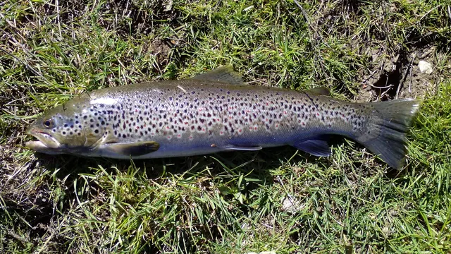
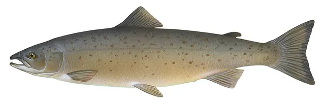
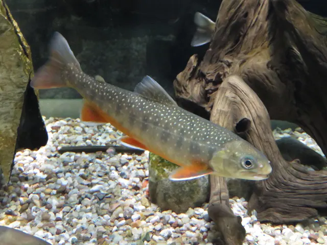
Fly fishing · 2
What these strengths mean
- Characteristic of this water
- This water is strongly identified with this species by the sources that cover it.
- Seasonal
- Well supported, and concentrated in part of the year rather than spread through it.
- Recorded here
- At least one credible public account of this species being caught here. That is all it means.
- How breadth is counted
- A fish documented at six marks is shown as six marks: breadth never raises the strength on its own. A fishery account describes the fishing; a recorded catch reports one specific catch. How evidence is weighed.
Fish documented nearby, not here
Nothing below has been documented at Lough Melvin itself. Each one has been documented at a named place on the same ground, and the places are listed with it. Treat this as what the water around here holds rather than as a catch list for this mark.
Also documented at neighbouring places
One or two accounts each, on the ground around here. Enough to know the fish is caught in these waters; not enough to say anything about this place.
From a boat
- Common bream — documented at The Erne at Enniskillen
- Roach — documented at The Erne at Enniskillen
- Northern pike — documented at Lough Macnean; The Erne at Enniskillen
- European perch — documented at The Erne at Enniskillen
How people fish it
Practised here: Fly fishing.
Methods the sources name for this ground. Each one is explained in full on its own page.
- Stillwater fly fishing
Fly fishing without current, where the angler supplies every movement and the problem becomes finding fish rather than presenting to them.
- Dry fly fishing
Presenting a floating artificial to a fish feeding at the surface, so that it drifts exactly as a natural insect would.
The ground and the water
- The ground
- A cross-border lough on the Fermanagh and Leitrim boundary: a shallow-to-moderate glacial lake with rocky shores, islands, gravel spawning tributaries and a short river to the Atlantic.
- Exposure
- Open western lough, exposed to Atlantic weather with a substantial fetch along its axis.
- Depth
- Mostly moderate depth with deeper holes, and rocky shallow margins around the islands.
- Tide and flow
- None. Level responds quickly to Atlantic rainfall, which is heavy and frequent here.
Through the year
A wild trout fishery of international scientific importance: the lough holds three genetically distinct and reproductively isolated brown trout populations — the gillaroo, the sonaghen and the ferox — which is among the clearest demonstrations anywhere of a single lake supporting separate trout lineages. Salmon run through in season.
The months the sources attach to each species here. Where a species carries no season it is listed underneath rather than assumed to run through the year.
| Species | J | F | M | A | M | J | J | A | S | O | N | D |
|---|---|---|---|---|---|---|---|---|---|---|---|---|
| Brown trout — characteristic of this water, recorded in March, April, May, June, July, August, September. | ||||||||||||
| Atlantic salmon — seasonal, recorded in April, May, June, July. |
Recorded here with no season stated: Arctic char.
Safety
Cold water shock — Can cause serious injury or death
UK coastal and inland water is cold enough for most of the year to trigger the involuntary gasp and the loss of swimming ability that decides most immersion deaths, and it does so within the first minute, long before hypothermia is relevant.
What reduces it: Wear a buoyancy aid rather than carry one, carry a means of calling for help on the person rather than in a bag, and plan on the assumption that an unplanned entry into the water is survivable only if somebody knows immediately.
Boat safety — Can cause serious injury or death
An exposed western lough where Atlantic weather arrives fast, with rocky shoals and islands that are hazardous to a boat under way in a chop.
What reduces it: Wear a buoyancy aid, take a local boatman or current local knowledge for the shoals, watch the western sky, and return before the weather rather than with it.
Biosecurity and disease transfer — Can cause serious injury or death
The three trout lineages depend on separate spawning tributaries and on genetic isolation. Stocking, fish movement and disease or invasive species carried on wet gear are the documented threats to a resource that exists nowhere else in this form.
What reduces it: Check, clean and dry everything between waters, never move fish or water between systems, and treat this lough's populations as irreplaceable rather than as a stock.
Rules and access
Licence
A rod licence is required, and Northern Ireland has two licensing authorities — DAERA and the Loughs Agency — covering different areas. Which one issues yours depends on where you are fishing.
Permission to fish
Separate, and both are needed. A rod licence plus a permit or day ticket for the specific water is the normal requirement here.
FishingHQ does not know the current access position here. Angling in Northern Ireland generally requires both a rod licence from the relevant fisheries body and a separate permit for the water, and the two are issued by different bodies. Rules, seasons and permit arrangements change. Check with the Department of Agriculture, Environment and Rural Affairs, the Loughs Agency where relevant, and the permit issuer before going.
Particular to this water: This ground carries conservation designations that constrain access, vehicles, bait collection and disturbance independently of any fishing rule.
Who holds the answer:
- The Department of Agriculture, Environment and Rural Affairs, for rod licensing and fisheries regulation.
- The Loughs Agency, in the Foyle and Carlingford catchments.
- The club, association or owner that issues the permit for the water.
- The Northern Ireland department responsible for agriculture, environment and rural affairs, which administers freshwater fisheries and rod licensing for this system.
- The Loughs Agency, the cross-border body whose licensing arrangements cover other parts of Northern Ireland and differ from those here — which is why the area matters.
- Waterways Ireland, the cross-border body responsible for navigation on the Erne system and the Shannon-Erne Waterway.
- The fishery owner, club or angling association, for the permit that is required in addition to the rod licence.
- The Northern Ireland Environment Agency, where a conservation designation affects the water or its species.
- Inland Fisheries Ireland, for the portion of the lough and catchment in the Republic.
Nearby fishing
Other publicly documented places within about 40 km, by distance. Positions are approximate public geography and are never exact marks.
- Rossnowlagh Beach — 10–25 km · Surf beach
- Mullaghmore Harbour — 10–25 km · Harbour wall
- Lough Macnean — 10–25 km · Lough
- St John's Point, Donegal — 25–40 km · Headland
- Killybegs harbour — 25–40 km · Harbour wall
- Streedagh Point — 25–40 km · Rock mark
- Rosses Point — 25–40 km · Headland
- The Erne at Enniskillen — 25–40 km · River reach
Sources for this place
- Freshwater Fishes of the British Isles — HarperCollins (New Naturalist 75), 1992 (Reference work)Relied on for: Distribution, habitat requirements and biology of the freshwater fishes of Britain and Ireland named here.States this directlyCitation checked — the work exists and is described correctly
- Trout & Salmon — Bauer Media (Specialist angling publication)Relied on for: Long-running published description of British and Irish game angling practice by river, beat and season.FishingHQ's interpretation of what it saysCitation checked — the work exists and is described correctly
- General angling website restatements of established technique — Various (Credible secondary source)Relied on for: Widely restated public descriptions of which waters are conventionally fished and how, recorded as practitioner consensus rather than as scholarship, and not relied on for access, permission or any current rule.Background and mechanism onlyCitation checked — the work exists and is described correctly
How FishingHQ labels evidence is explained in the evidence policy. Last reviewed 2026-08-16.