Westermarkelsdorf
Beach · Brackish water
A beach at the north-west corner of Fehmarn, which the island's guide calls a classic among its angling places and identifies by a leaning post standing in the water off the main car park. It says the bed further out is well structured, with mussel beds, fields of stones and clay edges, and that from level with a large lagoon southwards the water within casting range grows deeper.
Safety: cold water shock — can cause serious injury or death (general advice, not specific to this place). One more point applies here.
FishingHQ describes what this place is, not whether you may fish it. Access, permits and who to ask.
What you can catch here
Documented at this place, grouped by how you would be fishing, with how strongly the sources support each one. This is what has been written down, not a forecast, and being listed is never permission to fish.
From the shore · 3
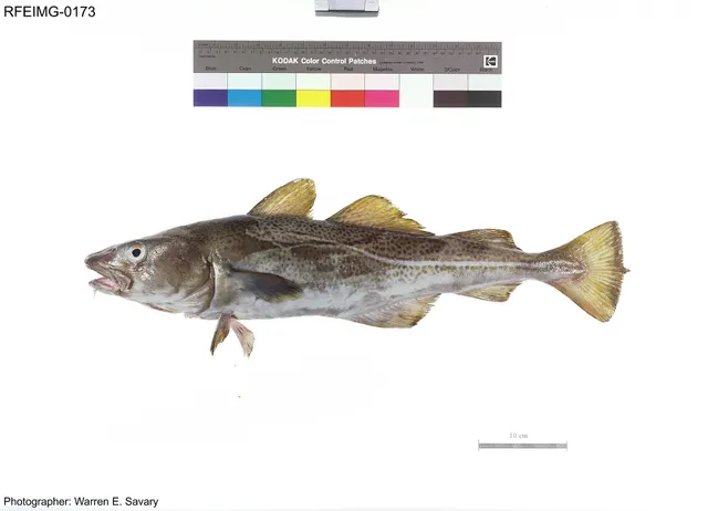 Atlantic codRegular local target1 placeWestermarkelsdorfOver beach
Photo: The U.S. Food and Drug Administration, via Wikimedia Commons, public domain; resized and trimmed to fit
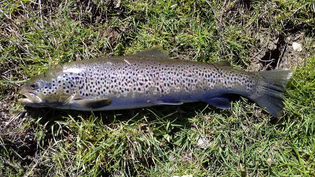 Brown troutRecorded here1 placeWestermarkelsdorfOver beach
Photo: Robermix, via Wikimedia Commons, CC0; resized and trimmed to fit
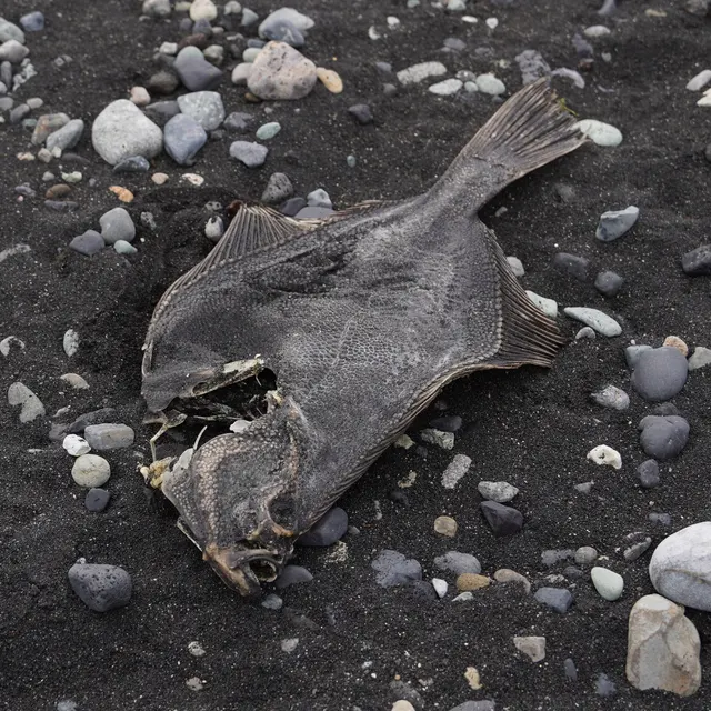 European flounderRecorded here1 placeWestermarkelsdorfOver beach
Photo: nbasargin, via iNaturalist, CC BY; resized and trimmed to fit


Fly fishing · 1
What these strengths mean
- Regular local target
- Fishing sources describe this as a normal local target here, not merely as caught.
- Recorded here
- At least one credible public account of this species being caught here. That is all it means.
- How breadth is counted
- A fish documented at six marks is shown as six marks: breadth never raises the strength on its own. A fishery account describes the fishing; a recorded catch reports one specific catch. How evidence is weighed.
Fish documented nearby, not here
Nothing below has been documented at Westermarkelsdorf itself. Each one has been documented at a named place on the same ground, and the places are listed with it. Treat this as what the water around here holds rather than as a catch list for this mark.
How people fish it
Practised here: Sea fishing.
Methods the sources name for this ground. Each one is explained in full on its own page.
- Surfcasting
Casting heavy baited tackle from a beach into surf — a method defined by distance, by tide, and by reading water that all looks the same.
- Spinning
Casting an artificial lure and retrieving it so that it moves like something alive — the most direct form of lure fishing.
Baits and lures for these fish
The baits and lures each of the fish above is commonly taken on, from that fish’s own page. This is what works for the fish, not a report of what people use on this particular water — local knowledge and the conditions on the day still decide.
Baits
- Lugworm — for Atlantic cod, European flounder
- Peeler crab — for Atlantic cod, European flounder
- Fish strip and cut bait — for Atlantic cod
- Maggots — for Brown trout
- Ragworm — for European flounder
- Squid and cuttlefish — for Atlantic cod
Lures
- Dry flies — for Brown trout
- Metal jigs — for Atlantic cod
- Nymphs — for Brown trout
- Soft plastics — for Atlantic cod
- Streamers — for Brown trout
- Terrestrial fly patterns — for Brown trout
- Wet flies — for Brown trout
How to catch them: Cod fishing · Brown trout fishing · Flounder fishing
Rods, reels and rigs for them: Atlantic cod · Brown trout · European flounder
The ground and the water
- The ground
- A beach at the north-west corner of Fehmarn, which the island's guide calls a classic among its angling places and identifies by a leaning post standing in the water off the main car park. It says the bed further out is well structured, with mussel beds, fields of stones and clay edges, and that from level with a large lagoon southwards the water within casting range grows deeper.
- Exposure
- Open to the north-west. The guide gives no wind for it.
Not to be confused with Fehmarn, which is a separate place on different ground.
Getting there
What public sources describe, last checked 2026-10-11. Car parks fill, services change and a path existing is not a path anybody may use — none of this is a guarantee of availability and none of it is permission to be anywhere.
- Getting to it
- At the north-west corner of the island. The island's guide says those who know the beach walk several hundred metres north or south from the car park, where it is fished less.
Parking
Main car park at Westermarkelsdorf
Public car park · Charging not established
The island's guide refers to a main car park directly by the leaning post offshore. It does not say whether it is charged.
Where this access information comes from
- Angelguide Fehmarn — Tourismus-Service Fehmarn, with the town of Fehmarn's offices named in it, 2020 (Local authority, harbour or protected-area body)Relied on for: The island guide's description of Westermarkelsdorf: the main car park by the leaning post, and the walk north or south to less fished water.States this directlyPassage read and verified
Safety
Cold water shock — Can cause serious injury or death
General safety for this kind of ground, not a finding about this place.
The Baltic sea-trout fishery is waded in winter, at first light, often alone, over a slippery boulder bottom in water cold enough that cold water shock removes breathing control and swimming ability within the first minute of an immersion.
What reduces it: Wear a wading belt tight over chest waders, carry a means of calling for help on the person rather than in a bag, tell somebody where you are and when you will be back, and wade shallower than feels necessary rather than deeper.
Worse when:
- Alone at dawn in winter, which is when the fishing is best and when nobody is watching.
Tides and being cut off — Can cause serious injury or death
General safety for this kind of ground, not a finding about this place.
On the Wadden flats a small vertical rise in the tide is an enormous horizontal advance, and the water fills the creeks first and spreads backward, so it appears between a person and the dyke while the ground under them is still dry.
What reduces it: Do not go out onto the flats unaccompanied — guided crossing exists on that coast because local judgement is that it cannot be done safely alone. Set a leaving time from the tide, and treat water appearing behind you as the signal to go immediately.
Worse when:
- In fog, which is frequent and removes the only navigation a featureless flat offers.
Rules and access
Particular to this water: A fishing licence and the state fishing levy are required on this coast; see the Fehmarn page for how a visitor obtains them. The guide asks anglers not to set up beside someone already fishing, and says those who walk further catch more.
Beyond what is stated above, FishingHQ does not know the current access position here, and Germany's structure surprises visitors more than most. In most of the country a fishing licence is issued only after a formal examination in fish biology, law and welfare — the qualification comes before the paper — and the arrangements for the Baltic and North Sea coasts differ between the coastal states. Species measures, closed seasons and protected areas apply and change. Check the current position with the fisheries authority of the state before going. This water is tidal and transitional, so the freshwater regime may also apply above the tidal limit: FishingHQ does not know the current access position here. German inland angling needs two separate things: the state fishing licence, which in most states follows an examination, and a permit for the specific water, which is sold by whoever holds the fishing right — usually a club, a commune or a private owner. Neither substitutes for the other, both differ between the sixteen states, and both change. Check with the state fisheries authority and with the water's rights-holder before going.
Who holds the answer:
- The fisheries authority of the federal state whose coast this is, for the licence, the coastal arrangements and the measures on them.
- The port or municipal authority, for access to structures.
- The fisheries authority of the federal state, for the licence and the examination behind it.
- The angling club, commune or private owner that holds the fishing right on the water and sells the permit for it.
- The fisheries authority of the federal state, which sets the licence, the examination behind it and any visitor arrangement.
- The angling club, commune or private owner holding the fishing right on the water, which issues the water permit and sets its conditions.
- The national park or protected-area administration on the Wadden coast, whose zoning constrains access independently of fishing rules.
- The waterways and shipping administration, for access to engineered river banks, groynes, locks and their surroundings.
- The veterinary and animal-welfare authority of the state, which is the body behind the welfare provisions of the framework.
- The state of Schleswig-Holstein's fisheries administration: the fishing licence, the state fishing levy, minimum sizes and closed seasons on its Baltic coast.
- The town of Fehmarn's public order office in Burg, which issues the tourist fishing licence on the island.
Nearby fishing
Other publicly documented places within about 40 km, by distance. Positions are approximate public geography and are never exact marks.
- Flügge — 5–10 km · Beach section
- Fehmarn — 10–25 km · Island
- Marienleuchte — 10–25 km · Rock mark
- The Fehmarnsund — 10–25 km · Sound or strait
- Katharinenhof — 10–25 km · Beach section
- Dovnsklint — 25–40 km · Beach section
- Fredmose — 25–40 km · Beach section
- Bagenkop — 25–40 km · Harbour wall
Sources for this place
- Angelguide Fehmarn — Tourismus-Service Fehmarn, with the town of Fehmarn's offices named in it, 2020 (Local authority, harbour or protected-area body)Relied on for: The island guide's account of Westermarkelsdorf: the leaning post and car park, the structured bed, cod and flatfish, and the deeper water to the south.States this directlyPassage read and verified
How FishingHQ labels evidence is explained in the evidence policy. Last reviewed 2026-10-11.
Something wrong or out of date?
If something on this page has changed, email us from your own account using the link that fits, with a link to where you saw the change if you can. Every report is checked by a person before anything is changed, and a report never appears on the site by itself. Please don’t send exact private marks.
Before you go
- Fish documented here
- 4 at this place itself. See them.
- Getting there
- Described from public sources, last checked 2026-10-11; the source itself dates from 2020. Getting there.
- Rules particular to this water
- A fishing licence and the state fishing levy are required on this coast; see the Fehmarn page for how a visitor obtains them. Source not tied: no recorded source has been matched to this statement.
- The guide asks anglers not to set up beside someone already fishing, and says those who walk further catch more. Source not tied: no recorded source has been matched to this statement.
Nothing here is watched for change. Sources and who to ask.
- Hazards particular to this place
- None recorded for this place; the hazards of the wider coast or water still apply.
Check before you travel
- Whether you may fish here, and whether a licence or permit is needed — start with the fisheries authority of the federal state whose coast this is.
- The tide times and the forecast for the day you go.
- Anything recorded here was true when it was read; it is not watched for change.