Trondheimsfjord
Sea loch · Brackish water · in Norway and the Nordic coast
Norway's third-longest fjord, running some 130 kilometres inland with a shallow sill at its mouth and very deep water behind it, fed by several substantial salmon rivers and fringed by farmland rather than by mountain for much of its length.
Safety: cold water shock — can cause serious injury or death (general advice, not specific to this place). One more point applies here.
FishingHQ describes what this place is, not whether you may fish it. Access, permits and who to ask.
Fishing places on Trondheimsfjord
6 publicly documented places inside this one, each with its own ground, catch and access.
Østmarkneset and the German quays, Lade
Rock mark
The north side of the Lade peninsula between Korsvika and Ringvebukta, with the old German quays and bunkers. TOFA says the bottom is very varied and testing for bait anglers, and that the Ladestien footpath runs round the point, so access is easy; walkers use it.
Documented here: Atlantic cod, Atlantic herring, Atlantic mackerel and 2 more
Pir I and the Hurtigruten quay, Trondheim
Harbour wall
The Hurtigruten terminal at Pir I, which TOFA calls perhaps the most used mark in the centre of Trondheim: easy to reach by bus, with good parking, and a fairly clean bottom where tackle does not often snag.
Documented here: Atlantic cod, Atlantic herring, Atlantic mackerel and 7 more
Harbour wall
The shore by Trondheim's public sea baths near the centre, with varied ground and patches of sand. TOFA says parking is difficult (paid parking by the railway station) and that buses run from Pirsenteret; bathers and swimmers use the area.
Documented here: Atlantic cod, Atlantic herring, Atlantic mackerel and 1 more
Harbour wall
Floating pontoons in the Skansen basin in Trondheim, which TOFA describes as simple, effective and family-friendly fishing, possible all year and best as the sea warms through late spring and early summer. Boats use the basin.
Documented here: Dab, European flounder, European plaice
Harbour wall
The pier at Storsand Camping east of Trondheim, which TOFA calls a species-rich mark for everyone, fishable all year, with a clean bottom where tackle rarely snags. Herring come in at times in the evening in large numbers.
Documented here: Atlantic cod, Atlantic herring, Dab and 4 more
Harbour wall
A quay at Trolla on the west side of Trondheim that TOFA calls a well-known mark with easy access by car and bus. The bottom is very varied, with an undercut edge that takes tackle, and TOFA says surf fishing is possible along the shore between Trolla Brug and the quay.
Documented here: Atlantic cod, Atlantic mackerel, Conger eel and 4 more
What you can catch here
Documented at this place, grouped by how you would be fishing, with how strongly the sources support each one. This is what has been written down, not a forecast, and being listed is never permission to fish.
From the shore · 2
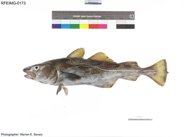 Atlantic codRepeatedly reported1 placeTrondheimsfjordOver sea loch
Photo: The U.S. Food and Drug Administration, via Wikimedia Commons, public domain; resized and trimmed to fit
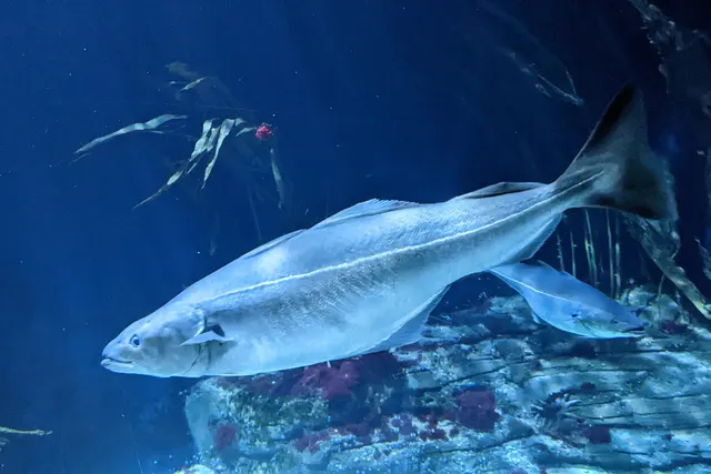 SaitheRepeatedly reported1 placeTrondheimsfjordOver sea loch
Photo: Wilhelm Thomas Fiege, via Wikimedia Commons, CC BY-SA 4.0; resized and trimmed to fit; shared under the same licence


From a boat · 2
- Atlantic codRepeatedly reported1 placeTrondheimsfjordOver sea loch
Photo: The U.S. Food and Drug Administration, via Wikimedia Commons, public domain; resized and trimmed to fit
- SaitheRepeatedly reported1 placeTrondheimsfjordOver sea loch
Photo: Wilhelm Thomas Fiege, via Wikimedia Commons, CC BY-SA 4.0; resized and trimmed to fit; shared under the same licence
What these strengths mean
- Repeatedly reported
- Several independent public accounts. Enough to say it happens more than once; not enough to call it a fishery.
- How breadth is counted
- A fish documented at six marks is shown as six marks: breadth never raises the strength on its own. A fishery account describes the fishing; a recorded catch reports one specific catch. How evidence is weighed.
Also associated with this ground
Recorded as present here without a documented method or strength behind them.
How people fish it
Practised here: Sea fishing, Fly fishing.
Methods the sources name for this ground. Each one is explained in full on its own page.
- Trolling
Towing lures or baits behind a moving boat to cover large volumes of water and locate scattered fish.
- Jigging
Working a weighted lure with a rising-and-falling motion, usually vertically, so it behaves like a wounded or fleeing baitfish.
- Spinning
Casting an artificial lure and retrieving it so that it moves like something alive — the most direct form of lure fishing.
Baits and lures for these fish
The baits and lures each of the fish above is commonly taken on, from that fish’s own page. This is what works for the fish, not a report of what people use on this particular water — local knowledge and the conditions on the day still decide.
Baits
- Peeler crab — for Atlantic cod, Saithe
- Crab and shellfish — for Saithe
- Fish strip and cut bait — for Atlantic cod
- Lugworm — for Atlantic cod
- Ragworm — for Saithe
- Sand eel — for Saithe
- Squid and cuttlefish — for Atlantic cod
Lures
- Metal jigs — for Atlantic cod, Saithe
- Soft plastics — for Atlantic cod, Saithe
- Spinners — for Saithe
How to catch them: Cod fishing · Coalfish fishing
Rods, reels and rigs for them: Atlantic cod · Saithe
The ground and the water
- The ground
- Norway's third-longest fjord, running some 130 kilometres inland with a shallow sill at its mouth and very deep water behind it, fed by several substantial salmon rivers and fringed by farmland rather than by mountain for much of its length.
- Depth
- A classic fjord profile: a shallow sill at the entrance and a deep basin inside it, so the deep water is comparatively still and old.
- Tide and flow
- A modest range with a strong outflowing brackish surface layer fed by the rivers, over much denser sea water beneath — which is why the surface and the depth fish quite differently.
Safety
Cold water shock — Can cause serious injury or death
General safety for this kind of ground, not a finding about this place.
Northern European water is cold enough for most of the year to trigger the involuntary gasp and the loss of swimming ability that decides most immersion deaths, and it does so within the first minute, long before hypothermia is relevant.
What reduces it: Wear a buoyancy aid rather than carry one, carry a means of calling for help on the person rather than in a bag, and plan on the assumption that an unplanned entry into the water is survivable only if somebody knows immediately.
Boat safety — Can cause serious injury or death
General safety for this kind of ground, not a finding about this place.
Small-boat fishing in cold deep water, frequently in unfamiliar waters, with weather that changes quickly and winds that come off high ground with little warning. Help can be a long way away and mobile coverage is not continuous.
What reduces it: Flotation suits rather than lifejackets in cold water — they buy time that a lifejacket alone does not. Check the forecast for the whole window. File a plan ashore. Carry communications that work beyond phone coverage. Do not go further than the weather and the boat justify.
Rules and access
FishingHQ does not know the current access position here. Norway permits recreational sea angling broadly, but rules on gear, quantity, export, minimum sizes, protected species and boat registration apply and change, and they differ for residents and visitors. Check the current position with the Norwegian Directorate of Fisheries before going. This water is tidal and transitional, so the freshwater regime may also apply above the tidal limit: FishingHQ does not know the current access position here. Norwegian freshwater fishing generally requires both a local fishing permit and, for salmon, sea trout and char, a separate national licence fee, and disinfection of equipment brought from abroad is required in many catchments to protect against parasite spread. Seasons and rules change. Check with the Norwegian Environment Agency and the local rights-holder before going.
Who holds the answer:
- The Norwegian Directorate of Fisheries, for recreational sea fishing measures.
- The harbour authority or landowner, for access.
- The Norwegian Environment Agency, for the national licence and for salmonid regulation.
- The local rights-holder or association that issues the water's permit.
- The national directorate responsible for fisheries, for sea fishing rules including species, size and quantity limits and export restrictions
- The national environment agency, for freshwater and anadromous species and the associated fee
- The landowner, association or river management body holding the fishing rights for any given fresh water
- County and municipal authorities, for local rules and for protected areas
- Border and customs authorities, for the rules on taking caught fish out of the country, which catch visitors out regularly
Nearby fishing
Other publicly documented places within about 40 km, by distance. Positions are approximate public geography and are never exact marks.
- Østmarkneset and the German quays, Lade — 10–25 km · Rock mark
- Trollakaia, Trondheim — 10–25 km · Harbour wall
- Pir I and the Hurtigruten quay, Trondheim — 10–25 km · Harbour wall
- Sjøbadet, Trondheim — 10–25 km · Harbour wall
- Skansen pontoons, Trondheim — 10–25 km · Harbour wall
- Storsand pier, Malvik — 25–40 km · Harbour wall
Sources for this place
- EMODnet — the European Marine Observation and Data Network — The European Commission, assembled from the national hydrographic offices, geological surveys and marine institutes of the member states (Scientific institute)Relied on for: Charted bathymetry, seabed substrate and seabed habitat for European sea areas, assembled from the national hydrographic and geological surveys, at the resolution the product publishes.States this directlyCitation checked — the work exists and is described correctly
- The European Environment Agency's assessments of Europe's waters, seas and coasts — European Environment Agency, Copenhagen (Conservation authority)Relied on for: Assessment of Europe's coasts and regional seas, including the condition of coastal water bodies, the pressures recorded on them and the coverage of designated sites.Background and mechanism onlyCitation checked — the work exists and is described correctly
- ICES Advice on fishing opportunities, catch and effort — International Council for the Exploration of the Sea (Scientific institute)Relied on for: Ecoregion description, stock distribution, nursery function and the hydrography of the north-east Atlantic and Baltic sea areas assessed.States this directlyCitation checked — the work exists and is described correctly
- FishBase: a global information system on fishes — Froese, R. and D. Pauly, eds. — FishBase Consortium (Scientific institute)Relied on for: Recorded distribution, depth range and habitat association of the species named for this ground.States this directlyPassage read and verified
How FishingHQ labels evidence is explained in the evidence policy. Last reviewed 2026-08-18.
Something wrong or out of date?
If something on this page has changed, email us from your own account using the link that fits, with a link to where you saw the change if you can. Every report is checked by a person before anything is changed, and a report never appears on the site by itself. Please don’t send exact private marks.
Before you go
- Fish documented here
- 4 at this place itself. See them.
- Getting there
- Not recorded. FishingHQ holds no sourced description of the way in.
- Rules particular to this water
- None recorded, which is not the same as none existing.
- Hazards particular to this place
- 1 recorded. Safety.
Check before you travel
- Whether you may fish here, and whether a licence or permit is needed — start with the Norwegian Directorate of Fisheries.
- The tide times and the forecast for the day you go.
- Anything recorded here was true when it was read; it is not watched for change.