Tongariro River
River reach · Fresh water · in New Zealand
The largest river running into Lake Taupō, flowing through Tūrangi: large and, in the guide's words, deceptively powerful. It carries about a third of the spawning trout of the whole catchment. The middle reaches beside the highway are the most fished; the delta, with two mouths that move after floods, is reached only by boat; the upper gorge is fished mainly by raft.
FishingHQ describes what this place is, not whether you may fish it. Access, permits and who to ask.
What you can catch here
Documented at this place, grouped by how you would be fishing, with how strongly the sources support each one. This is what has been written down, not a forecast, and being listed is never permission to fish.
From the shore · 2
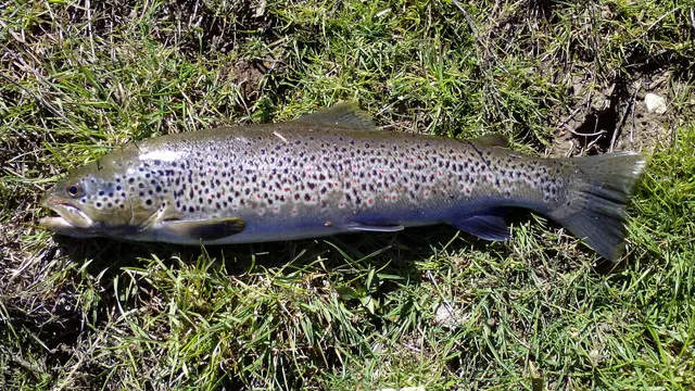 Brown troutRegular local target1 placeTongariro RiverOver river reach
Photo: Robermix, via Wikimedia Commons, CC0; resized and trimmed to fit
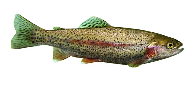 Rainbow troutSeasonal1 placeTongariro RiverOver river reachAround Apr–Nov
Photo: Jonathunder, via Wikimedia Commons, CC BY-SA 3.0; resized and trimmed to fit; shared under the same licence


Fly fishing · 2
- Brown troutRegular local target1 placeTongariro RiverOver river reach
Photo: Robermix, via Wikimedia Commons, CC0; resized and trimmed to fit
- Rainbow troutSeasonal1 placeTongariro RiverOver river reachAround Apr–Nov
Photo: Jonathunder, via Wikimedia Commons, CC BY-SA 3.0; resized and trimmed to fit; shared under the same licence
What these strengths mean
- Regular local target
- Fishing sources describe this as a normal local target here, not merely as caught.
- Seasonal
- Well supported, and concentrated in part of the year rather than spread through it.
- How breadth is counted
- A fish documented at six marks is shown as six marks: breadth never raises the strength on its own. A fishery account describes the fishing; a recorded catch reports one specific catch. How evidence is weighed.
How people fish it
Practised here: Fly fishing.
Methods the sources name for this ground. Each one is explained in full on its own page.
- Nymphing
Fishing sunk imitations of immature insects at the fish's depth — the most productive fly method, and the one where take detection is everything.
- Dry fly fishing
Presenting a floating artificial to a fish feeding at the surface, so that it drifts exactly as a natural insect would.
Baits and lures for these fish
The baits and lures each of the fish above is commonly taken on, from that fish’s own page. This is what works for the fish, not a report of what people use on this particular water — local knowledge and the conditions on the day still decide.
Baits
- Maggots — for Brown trout
Lures
How to catch them: Brown trout fishing
Rods, reels and rigs for them: Brown trout
The ground and the water
- The ground
- The largest river running into Lake Taupō, flowing through Tūrangi: large and, in the guide's words, deceptively powerful. It carries about a third of the spawning trout of the whole catchment. The middle reaches beside the highway are the most fished; the delta, with two mouths that move after floods, is reached only by boat; the upper gorge is fished mainly by raft.
Getting there
What public sources describe, last checked 2026-10-10. Car parks fill, services change and a path existing is not a path anybody may use — none of this is a guarantee of availability and none of it is permission to be anywhere.
- Getting to it
- State Highway 1 runs through Tūrangi beside the river as far as Red Hut Bridge, and most pools on the middle reaches are reached by a side track or on foot. The delta has no road or track. The guide warns that the river floods after heavy rain, that hydro releases change its level on set days, and that the delta's soft bottom and steep drop-offs make wading there unwise.
Where this access information comes from
- NZFishing.com: where to fish, water by water — NZFishing.com (Specialist angling publication)Relied on for: The specialist guide's page for this water: the fish it gives, where and how it says they are fished for, the seasons, the access it describes and the hazards it names.States this directlyPassage read and verified
Through the year
Spawning runs come up from the lake between April and November, with the main rainbow runs from late July to September, set off by rain and colder water. The guide says the best fishing is usually as the river starts to clear after heavy rain, and describes dry-fly fishing on summer evenings.
Rules and access
Licence
The Taupō fishing district has its own licence, issued by the Department of Conservation. A Fish & Game licence does not cover it.
Permission to fish
Separate. Much of the lake shore and river bank is private Māori land; the guides read describe a walking right-of-way for licensed anglers along parts of it, and say its extent is disputed in places.
Particular to this water: This water is in the Taupō fishing district, managed by the Department of Conservation under its own licence and rules; a Fish & Game licence does not cover it. Nothing here states that it is open. Check the current regulations with the department before fishing. The guide describes the river below a named pool as fly fishing only, a winter limit above it, and a tributary closed to fishing.
Beyond what is stated above, FishingHQ does not know the current access position here. The Taupō fishery is managed by the Department of Conservation and is not covered by a Fish & Game licence: it has its own licence and its own rules, which make most of its rivers fly fishing only, close reaches and tributaries for part or all of the year, and restrict fishing from boats near river mouths. Guides to it disagree about the limits, which change. Much of the lake shore and river bank is private Māori land crossed by a walking right-of-way whose extent is disputed in places. Check the current position with the Department of Conservation's Tūrangi office before going.
Who holds the answer:
- The Department of Conservation, which manages the Taupō fishery, issues its licence and publishes its regulations; its Tūrangi office is the contact.
- The landowner, where reaching the water means crossing private land.
- The national fisheries agency, for recreational sea fishing rules including size limits, bag limits and area-specific measures
- Regional fish and game bodies, for freshwater trout and salmon licensing, seasons and local rules
- The separate management arrangement covering the central North Island trout fishery, which operates under its own licence
- The national conservation agency, for marine reserves and protected species
- Customary fisheries authorities and local iwi, where customary provisions apply
- Department of Conservation, Taupō Fishery (Tūrangi office): manages the fishery, issues its licence and publishes its regulations.
Nearby fishing
Other publicly documented places within about 40 km, by distance. Positions are approximate public geography and are never exact marks.
- Waiotaka Stream — 10–25 km · River reach
- Waimarino River — 10–25 km · River reach
- Tauranga-Taupō River — 10–25 km · River reach
- Lake Otamangakau — 10–25 km · Reservoir
- Lake Kuratau — 10–25 km · Reservoir
- Hinemaiaia River — 25–40 km · River reach
- Lake Taupō — 25–40 km · Lake
- Waitahanui River — 25–40 km · River reach
Sources for this place
- NZFishing.com: where to fish, water by water — NZFishing.com (Specialist angling publication)Relied on for: The specialist guide's page for this water: the fish it gives, where and how it says they are fished for, the seasons, the access it describes and the hazards it names.States this directlyPassage read and verified
- Destination Great Lake Taupō: trout fishing in Taupō — Destination Great Lake Taupō (Credible secondary source)Relied on for: The district tourism body's account of the Taupō fishery: that brown and rainbow trout are fished for in this water, how, and that the Department of Conservation manages it.States this directlyPassage read and verified
How FishingHQ labels evidence is explained in the evidence policy. Last reviewed 2026-10-10.
Something wrong or out of date?
If something on this page has changed, email us from your own account using the link that fits, with a link to where you saw the change if you can. Every report is checked by a person before anything is changed, and a report never appears on the site by itself. Please don’t send exact private marks.
Before you go
- Fish documented here
- 4 at this place itself. See them.
- Getting there
- Described from public sources, last checked 2026-10-10. Getting there.
- Rules particular to this water
- This water is in the Taupō fishing district, managed by the Department of Conservation under its own licence and rules; a Fish & Game licence does not cover it. Source not tied: no recorded source has been matched to this statement.
- Nothing here states that it is open. Source not tied: no recorded source has been matched to this statement.
- Check the current regulations with the department before fishing. Source not tied: no recorded source has been matched to this statement.
- The guide describes the river below a named pool as fly fishing only, a winter limit above it, and a tributary closed to fishing. Source not tied: no recorded source has been matched to this statement.
Nothing here is watched for change. Sources and who to ask.
- Hazards particular to this place
- None recorded for this place; the hazards of the wider coast or water still apply.
Check before you travel
- Whether you may fish here, and whether a licence or permit is needed — start with the Department of Conservation.
- Who holds the fishing right on the stretch you mean to fish, and the river level.
- Anything recorded here was true when it was read; it is not watched for change.