The south-west approaches
Sea area · Salt water · in The Cornish and Devon coasts
The open water and wreck ground off the south-west peninsula, where the shelf carries a dense concentration of wrecks and where warm water pushes in from the south-west through the summer and autumn.
Safety: boat traffic and being seen — can cause serious injury or death. 2 more points apply here.
FishingHQ describes what this place is, not whether you may fish it. Access, permits and who to ask.
What you can catch here
Documented at this place, grouped by how you would be fishing, with how strongly the sources support each one. This is what has been written down, not a forecast, and being listed is never permission to fish.
From a boat · 5
- Blue sharkSeasonal1 place · 2 fishery accounts · 2 independent sourcesThe south-west approachesOver sea areaAround Jun–Sept
 Conger eelRepeatedly reported1 place · 1 fishery account · 1 sourceThe south-west approachesOver sea area
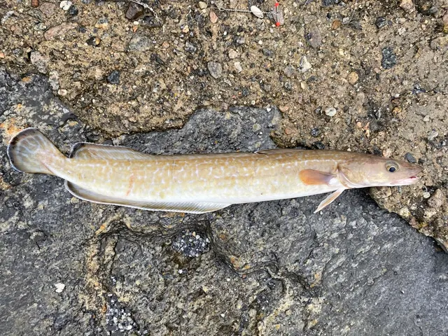 LingRepeatedly reported1 place · 1 fishery account · 1 sourceThe south-west approachesOver sea area
 PollackRepeatedly reported1 place · 1 fishery account · 1 sourceThe south-west approachesOver sea area
 Atlantic codRecorded here1 place · 1 fishery account · 1 sourceThe south-west approachesOver sea area
On a charter · 6
- Blue sharkSeasonal1 place · 2 fishery accounts · 2 independent sourcesThe south-west approachesOver sea areaAround Jun–Sept
- Atlantic bluefin tunaSeasonal1 place · 1 fishery account · 1 sourceThe south-west approachesOver sea areaAround Aug–Dec
- Conger eelRepeatedly reported1 place · 1 fishery account · 1 sourceThe south-west approachesOver sea area
- LingRepeatedly reported1 place · 1 fishery account · 1 sourceThe south-west approachesOver sea area
- PollackRepeatedly reported1 place · 1 fishery account · 1 sourceThe south-west approachesOver sea area
- Atlantic codRecorded here1 place · 1 fishery account · 1 sourceThe south-west approachesOver sea area
What these strengths mean
- Seasonal
- Well supported, and concentrated in part of the year rather than spread through it.
- Repeatedly reported
- Several independent public accounts. Enough to say it happens more than once; not enough to call it a fishery.
- Recorded here
- At least one credible public account of this species being caught here. That is all it means.
- How breadth is counted
- A fish documented at six marks is shown as six marks: breadth never raises the strength on its own. A fishery account describes the fishing; a recorded catch reports one specific catch. How evidence is weighed.
Also associated with this ground
Recorded as present here without a documented method or strength behind them.
How people fish it
Practised here: Sea fishing.
Methods the sources name for this ground. Each one is explained in full on its own page.
- Jigging
Working a weighted lure with a rising-and-falling motion, usually vertically, so it behaves like a wounded or fleeing baitfish.
- Trolling
Towing lures or baits behind a moving boat to cover large volumes of water and locate scattered fish.
- Deadbaiting
Presenting a dead fish as bait for predators — a method that works because scavenging is normal predator behaviour, not an exception.
- Feathering and multi-lure traces
A string of small lures on droppers, worked in the water column — how most people in Britain and Ireland catch their first sea fish, and the method most likely to catch far more than anybody intended.
Baits and lures for these fish
The baits and lures each of the fish above is commonly taken on, from that fish’s own page. This is what works for the fish, not a report of what people use on this particular water — local knowledge and the conditions on the day still decide.
Baits
- Fish strip and cut bait — for Conger eel, Atlantic cod
- Squid and cuttlefish — for Conger eel, Atlantic cod
- Lugworm — for Atlantic cod
- Peeler crab — for Atlantic cod
- Ragworm — for Pollack
- Sand eel — for Pollack
Lures
- Metal jigs — for Ling, Pollack, Atlantic cod
- Soft plastics — for Pollack, Atlantic cod
- Jigs and jig heads — for Pollack
The ground and the water
- The ground
- The open water and wreck ground off the south-west peninsula, where the shelf carries a dense concentration of wrecks and where warm water pushes in from the south-west through the summer and autumn.
- Exposure
- Open ocean. Weather decides whether any of it is fishable.
- Depth
- Shelf water deepening to the south and west, with wrecks standing proud of an otherwise featureless bottom.
Through the year
Blue shark through the summer; the permitted bluefin programme runs from late summer into the winter.
The months the sources attach to each species here. Where a species carries no season it is listed underneath rather than assumed to run through the year.
| Species | J | F | M | A | M | J | J | A | S | O | N | D |
|---|---|---|---|---|---|---|---|---|---|---|---|---|
| Blue shark — seasonal, recorded in June, July, August, September. | ||||||||||||
| Atlantic bluefin tuna — seasonal, recorded in August, September, October, November, December. |
Recorded here with no season stated: Conger eel, Ling, Pollack, Atlantic cod.
Safety
Boat traffic and being seen — Can cause serious injury or death
Summer small-craft traffic on this coast is heavy and fast, and a swimmer, breath-hold diver or small float is nearly invisible from a planing hull until it is too close to alter course.
What reduces it: Carry a surface marker buoy with a dive flag and keep it directly above the diver, work inside marked zones where they exist, and leave water where traffic is heavy rather than trying to be seen in it.
Cliffs and rock platforms — Can cause serious injury or death
Atlantic groundswell arrives from storms thousands of miles away, on days that are locally calm and sunny, and it comes in sets in which one wave runs far higher than the rest. Anglers are swept from rock platforms that had been dry for twenty minutes, into deep water with no shelf to climb out onto and frequently with a long, hard climb back to the access path.
What reduces it: Check the swell forecast rather than the wind forecast; watch any mark for a long period before committing, and assume the sets you have seen are not the largest; never fish rock alone; wear a buoyancy aid; and plan the exit for the sea state you might have rather than the one you arrived in.
Worse when:
- Any Atlantic swell forecast on the north coast, regardless of local wind
- Rising tide, which brings the sets progressively higher up the platform
- Descents that are hard to reverse, wet rock and weed, and darkness
- Stretches with no mobile coverage, where raising the alarm is not possible
Moving water and currents — Can cause serious injury or death
The north coast's surf beaches carry strong rip currents, which run seaward through gaps in the sandbars and can take a wading angler off their feet and out beyond the surf line faster than they can walk back.
What reduces it: Do not wade deep in surf; learn to identify the calmer, darker, less-breaking channels that mark a rip and stay out of them; and if caught, do not swim against it — swim across the current parallel to the beach until out of it.
Rules and access
FishingHQ does not know the current access position here. Shore angling in England is not rod-licensed, but access rights, landowner permission, local authority and harbour byelaws, national and inshore fisheries measures, and site designations all apply and all change. Check the current position with the relevant inshore fisheries and conservation authority, the harbour or local authority, and the landowner before going.
Particular to this water: Recreational bluefin tuna angling in English waters runs only through a permitted catch-and-release tagging programme fished from qualifying charter boats. There is no open recreational bluefin fishery and no fish may be retained. Blue shark angling in UK waters is catch-and-release in practice and is governed by species protections that change; check current rules before booking.
Who holds the answer:
- The Inshore Fisheries and Conservation Authority for the district, which makes and enforces inshore byelaws.
- The Marine Management Organisation, for national recreational sea fishing measures in English waters.
- The local authority and, where one exists, the harbour authority, for access, byelaws and shellfish classification.
- The national fisheries authority for England, for licensing of freshwater and migratory fishing and for fisheries enforcement
- The relevant inshore fisheries and conservation authority for the district, which sets and enforces local sea fisheries byelaws
- The body managing any marine protected area on the stretch concerned
- The local authority environmental health service, for shellfish classification and public health closures
- The harbour authority for working harbours and quays
- The relevant estuary or river management body, where an estuary carries its own arrangements
Nearby fishing
Other publicly documented places within about 40 km, by distance. Positions are approximate public geography and are never exact marks.
- Lizard Point — 5–10 km · Headland
- The Helford — 10–25 km · Estuary
- Porthleven — 10–25 km · Harbour wall
- Falmouth and Castle Beach — 25–40 km · Beach section
- Falmouth — 25–40 km · Charter departure port
- Newlyn North Pier — 25–40 km · Pier
- Penzance and Mousehole — 25–40 km · Harbour wall
- The Fal estuary — 25–40 km · Estuary
Sources for this place
- Sea Angler — Bauer Media (Specialist angling publication)Relied on for: Long-running published description of British sea angling practice by region, ground type and named mark.FishingHQ's interpretation of what it saysCitation checked — the work exists and is described correctly
- General angling website restatements of established technique — Various (Credible secondary source)Relied on for: Widely restated public descriptions of which places are conventionally fished and how, recorded as practitioner consensus rather than as scholarship, and not relied on for access, permission or any current rule.Background and mechanism onlyCitation checked — the work exists and is described correctly
How FishingHQ labels evidence is explained in the evidence policy. Last reviewed 2026-08-16.