The Test at Stockbridge
River reach · Fresh water · in The Hampshire chalk streams
The archetypal chalk stream: a shallow, clear, gravel-bedded river braided into multiple carriers through a wide flood meadow, with dense ranunculus growth, marl and silt margins and hatch pools at the old mill structures.
Safety: drowning and immersion — can cause serious injury or death. One more point applies here.
FishingHQ describes what this place is, not whether you may fish it. Access, permits and who to ask.
What you can catch here
Documented at this place, grouped by how you would be fishing, with how strongly the sources support each one. This is what has been written down, not a forecast, and being listed is never permission to fish.
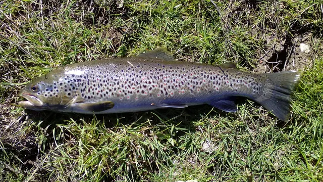
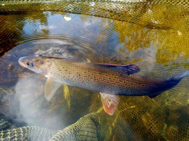
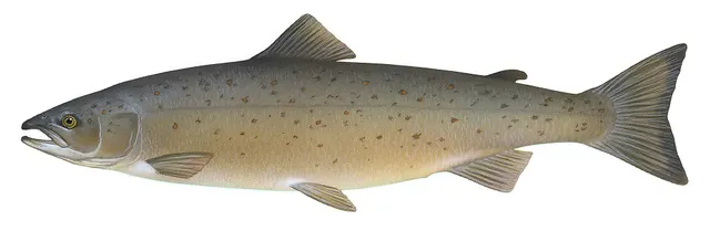
Fly fishing · 3
What these strengths mean
- Characteristic of this water
- This water is strongly identified with this species by the sources that cover it.
- Seasonal
- Well supported, and concentrated in part of the year rather than spread through it.
- Recorded here
- At least one credible public account of this species being caught here. That is all it means.
- How breadth is counted
- A fish documented at six marks is shown as six marks: breadth never raises the strength on its own. A fishery account describes the fishing; a recorded catch reports one specific catch. How evidence is weighed.
How people fish it
Practised here: Fly fishing.
Methods the sources name for this ground. Each one is explained in full on its own page.
- Dry fly fishing
Presenting a floating artificial to a fish feeding at the surface, so that it drifts exactly as a natural insect would.
The ground and the water
- The ground
- The archetypal chalk stream: a shallow, clear, gravel-bedded river braided into multiple carriers through a wide flood meadow, with dense ranunculus growth, marl and silt margins and hatch pools at the old mill structures.
- Exposure
- Open valley with managed bankside vegetation; the river is small enough that wind matters for casting rather than for safety.
- Depth
- Shallow and even, with deeper hatch pools and carriers — this is a river to be read rather than plumbed.
- Tide and flow
- Non-tidal and, unusually, near-constant in flow. Groundwater from the chalk aquifer keeps discharge and temperature far more stable than any surface-fed river, which is the whole reason chalk streams are what they are.
Through the year
The dry-fly season built around the mayfly hatch in late spring, trout through the summer, and grayling into the winter — a calendar set by insect emergence rather than by water temperature alone.
The months the sources attach to each species here. Where a species carries no season it is listed underneath rather than assumed to run through the year.
| Species | J | F | M | A | M | J | J | A | S | O | N | D |
|---|---|---|---|---|---|---|---|---|---|---|---|---|
| Brown trout — characteristic of this water, recorded in April, May, June, July, August, September, October. | ||||||||||||
| Grayling — seasonal, recorded in October, November, December, January, February, March. |
Recorded here with no season stated: Atlantic salmon.
Safety
Drowning and immersion — Can cause serious injury or death
A soft, undercut or steep bank gives way, or a wader steps off a shelf, and an angler enters water that is deeper and colder than the surface suggests, in clothing and boots that fill.
What reduces it: Test the bank before committing weight, wade only where you can see or have felt the bottom, wear a buoyancy aid on any water you would not want to swim in clothes, and do not fish alone at night on a steep or undercut bank.
Biosecurity and disease transfer — Can cause injury needing treatment
Chalk streams are among the rarest and most sensitive freshwater habitats in the world, and invasive plants and animals moved on wet gear establish readily in their stable conditions.
What reduces it: Check, clean and dry everything between waters, and treat felt-soled boots as a vector that should not be moved between catchments at all.
Rules and access
Licence
A rod licence is required for freshwater rod fishing in England, issued by the Environment Agency.
Permission to fish
Separate. Almost all fishing rights are held by a club, association, riparian owner or navigation authority, and the licence does not grant access to any of them.
FishingHQ does not know the current access position here. Freshwater rod fishing in England requires a current rod licence AND separate permission from whoever controls the fishing, which is frequently a club, riparian owner or navigation authority rather than a public body. Close seasons, byelaws and local rules apply and change. Check with the Environment Agency and with the controlling club or owner before going.
Particular to this water: This ground carries conservation designations that constrain access, vehicles, bait collection and disturbance independently of any fishing rule.
Who holds the answer:
- The Environment Agency, for rod licensing, close seasons and fisheries byelaws in England.
- The club, association, riparian owner or navigation authority that controls the fishing.
- The national fisheries authority for England, for the rod licence, close seasons and statutory rules
- The owner, syndicate, estate or letting agent for the specific beat, who grants the fishing permission and sets the beat rules
- The river keeper or ghillie, who is the operative source of what is permitted and expected on the day
- The statutory nature conservation body, where a stretch carries a conservation designation
- The local rivers trust or catchment partnership, for the current condition of the water and any advisory restriction
Nearby fishing
Other publicly documented places within about 40 km, by distance. Positions are approximate public geography and are never exact marks.
- The Itchen at Winchester — 10–25 km · River reach
- The Kennet at Newbury — 25–40 km · River reach
- Calshot Spit — 25–40 km · Headland
- The Hampshire Avon at Ringwood — 25–40 km · River reach
- The Kennet and Avon Canal — 25–40 km · Canal section
Sources for this place
- Environment Agency fisheries management, byelaws and rod licensing information — Environment Agency (Government fisheries body)Relied on for: Freshwater and transitional-water fisheries management in England, the structure of rod licensing, close seasons and byelaws, and the monitoring of rivers and stillwaters.States this directlyCitation checked — the work exists and is described correctly
- Trout & Salmon — Bauer Media (Specialist angling publication)Relied on for: Long-running published description of British and Irish game angling practice by river, beat and season.FishingHQ's interpretation of what it saysCitation checked — the work exists and is described correctly
- General angling website restatements of established technique — Various (Credible secondary source)Relied on for: Widely restated public descriptions of which waters are conventionally fished and how, recorded as practitioner consensus rather than as scholarship, and not relied on for access, permission or any current rule.Background and mechanism onlyCitation checked — the work exists and is described correctly
- Freshwater Fishes of the British Isles — HarperCollins (New Naturalist 75), 1992 (Reference work)Relied on for: Distribution, habitat requirements and biology of the freshwater fishes of Britain and Ireland named here.States this directlyCitation checked — the work exists and is described correctly
How FishingHQ labels evidence is explained in the evidence policy. Last reviewed 2026-08-16.