Parramatta River
Estuary · Brackish water
The tidal river from the harbour up to Parramatta, fished from wharves, parks, reserves and rocky outcrops; the department maps twenty-eight places on it and gives dusky flathead, bream, mulloway, whiting, luderick, mullet and silver trevally as common fish, with Australian bass and estuary perch in the upper reaches.
Safety: contamination and toxins in the catch — can cause injury needing treatment. One more point applies here.
FishingHQ describes what this place is, not whether you may fish it. Access, permits and who to ask.
Fishing places on Parramatta River
One publicly documented place inside this one.
Parramatta River, Gladesville to Ryde
Estuary
The tidal Parramatta River between Gladesville Bridge and Ryde Bridge, upstream of the harbour proper. The department says soft plastics and vibes are as effective as fresh bait for mulloway here, and names Huntleys Point, Drummoyne and Ryde among its mulloway hot spots.
Documented here: Dusky kob
What you can catch here
Documented at this place, grouped by how you would be fishing, with how strongly the sources support each one. This is what has been written down, not a forecast, and being listed is never permission to fish.
From the shore · 6
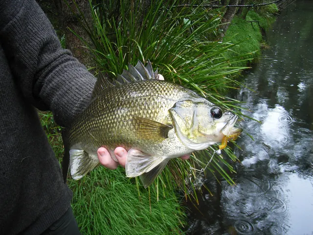 Australian bassRegular local target1 placeParramatta RiverOver estuary
Photo: Codman at en.wikipedia, via Wikimedia Commons, CC BY-SA 3.0; resized; shared under the same licence
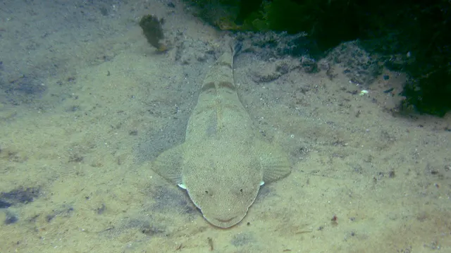 Dusky flatheadRegular local target1 placeParramatta RiverOver estuary
Photo: Sylke Rohrlach from Sydney, via Wikimedia Commons, CC BY-SA 2.0; resized and trimmed to fit; shared under the same licence
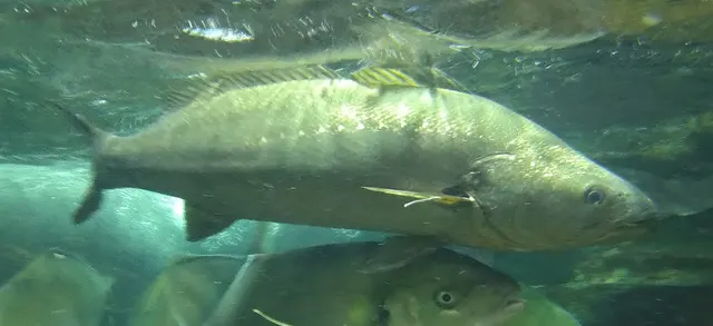 Dusky kobRegular local target1 placeParramatta RiverOver estuary
Photo: タウナギ, via Wikimedia Commons, CC BY-SA 4.0; resized and trimmed to fit; shared under the same licence
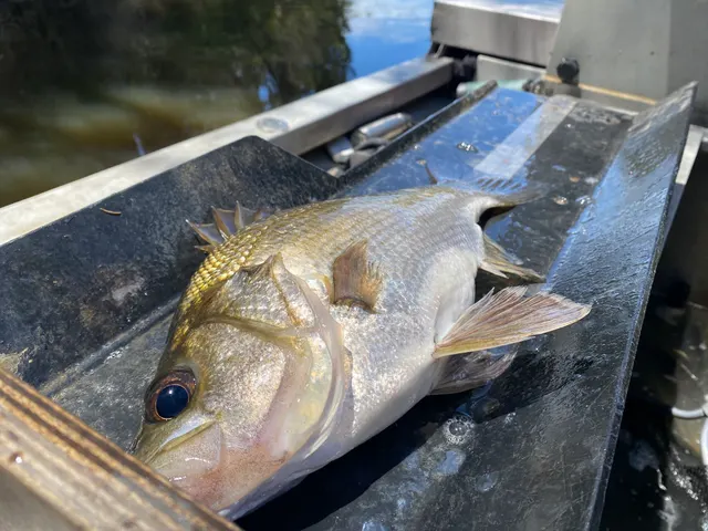 Estuary perchRegular local target1 placeParramatta RiverOver estuary
Photo: Bryce Watts-Parker, via iNaturalist, CC BY; resized
- LuderickRegular local target1 placeParramatta RiverOver estuary
- Silver trevallyRegular local target1 placeParramatta RiverOver estuary


From a boat · 2
- Dusky flatheadRegular local target1 placeParramatta RiverOver estuary
Photo: Sylke Rohrlach from Sydney, via Wikimedia Commons, CC BY-SA 2.0; resized and trimmed to fit; shared under the same licence
- Dusky kobRegular local target1 placeParramatta RiverOver estuary
Photo: タウナギ, via Wikimedia Commons, CC BY-SA 4.0; resized and trimmed to fit; shared under the same licence
From a kayak · 2
- Australian bassRegular local target1 placeParramatta RiverOver estuary
Photo: Codman at en.wikipedia, via Wikimedia Commons, CC BY-SA 3.0; resized; shared under the same licence
- Estuary perchRegular local target1 placeParramatta RiverOver estuary
Photo: Bryce Watts-Parker, via iNaturalist, CC BY; resized
What these strengths mean
- Regular local target
- Fishing sources describe this as a normal local target here, not merely as caught.
- How breadth is counted
- A fish documented at six marks is shown as six marks: breadth never raises the strength on its own. A fishery account describes the fishing; a recorded catch reports one specific catch. How evidence is weighed.
Fish documented nearby, not here
Nothing below has been documented at Parramatta River itself. Each one has been documented at a named place on the same ground, and the places are listed with it. Treat this as what the water around here holds rather than as a catch list for this mark.
Widely documented on this ground
Documented at three or more neighbouring places, fished a way this place is also fished. That is a pattern about the ground rather than about any one mark, and it is the closest this site comes to saying you will probably meet a fish somewhere nothing has been written about.
From the shore
- Yellowtail kingfish — documented at Walsh Bay piers; Clifton Gardens Wharf; McMahons Point (+4 more)
- Kahawai — documented at Walsh Bay piers; Clifton Gardens Wharf; McMahons Point (+2 more)
Named only as a group
The guide for Parramatta River also names these fish by a name that covers more than one species here. It does not say which, so none is attached to this place.
- bream — could be Black bream or Yellowfin bream. Black bream and yellowfin bream overlap in south-east Australia and hybridise in Victoria; the working difference is the colour of the pelvic and anal fins.
- whiting — could be Sand whiting, King George whiting or Yellowfin whiting. The NSW department's Great Lakes guide says its whiting are sand or yellowfin whiting, and the Victorian bays' are King George whiting; "whiting" alone does not say which.
- mullet — could be Yellow-eye mullet or Sea mullet. Both occur in south-east Australian estuaries: on the Hopkins the Victorian agency names yellow eye mullet as a key fish and sea mullet as an occasional one, and "mullet" alone does not say which.
How people fish it
Practised here: Sea fishing, Lure fishing.
Methods the sources name for this ground. Each one is explained in full on its own page.
- Ledgering
Fishing a bait on the bottom held by a weight, with no float — the simplest way to fish at distance, in depth, or in wind.
- Spinning
Casting an artificial lure and retrieving it so that it moves like something alive — the most direct form of lure fishing.
- Kayak fishing
A platform rather than a technique: quiet, shallow-draught access to water no other craft reaches, bought at the price of exposure, and a discipline where the decision not to launch is part of the skill.
Baits and lures for these fish
The baits and lures each of the fish above is commonly taken on, from that fish’s own page. This is what works for the fish, not a report of what people use on this particular water — local knowledge and the conditions on the day still decide.
Lures
- Soft plastics — for Australian bass, Dusky flathead, Silver trevally
- Surface lures — for Australian bass
The ground and the water
- The ground
- The tidal river from the harbour up to Parramatta, fished from wharves, parks, reserves and rocky outcrops; the department maps twenty-eight places on it and gives dusky flathead, bream, mulloway, whiting, luderick, mullet and silver trevally as common fish, with Australian bass and estuary perch in the upper reaches.
Through the year
Mulloway and bream all year; whiting November to April; mulloway best near the tide change and at dawn, dusk and night.
Safety
Contamination and toxins in the catch — Can cause injury needing treatment
This water is west of the Sydney Harbour Bridge. Tests found elevated dioxins in fish and crustaceans across the harbour, the Parramatta River and connected tidal waters, and on an expert panel's advice the government recommends that no fish or crustacean caught west of the bridge be eaten.
What reduces it: Release what you catch, as the department advises. Fishing is not banned; eating the catch is what the advice is about.
Boat traffic and being seen — Can cause injury needing treatment
The department calls the Parramatta River an extremely busy waterway, with significant boat traffic, ferries, industry and commuters; on ferry wharves vessels and passengers have priority.
What reduces it: Clear lines and tackle when a vessel approaches a wharf, keep off commuter seating and access ways, and keep noise down at night, as the department asks.
Rules and access
Particular to this water: The river is an intertidal protected area: no seashore animal may be taken, crabs, pipis, oysters and nippers included. All fishing is prohibited in the Duck River and Homebush Bay, including Haslams and Powells creeks. Fishing is prohibited from 5 am to 10 am daily on the Kissing Point, Abbotsford and Chiswick ferry wharves. Council, leased and private land has its own rules; check fishing is allowed at each place.
Beyond what is stated above, FishingHQ does not know the current access position here. New South Wales requires its recreational fishing fee to be paid in all its waters, with exemptions the state lists. Marine parks and aquatic reserves have zones where fishing is not allowed or only some methods are, much of the shore is an intertidal protected area where shellfish and other invertebrates may not be taken, the state publishes advice against eating fish from some waters, and wearing a lifejacket is the law when rock fishing in declared council areas. Bag and size limits change. Check the current position with the NSW Department of Primary Industries and Regional Development before going. This water is tidal and transitional, so the freshwater regime may also apply above the tidal limit: FishingHQ does not know the current access position here. The New South Wales fishing fee applies in fresh water too, trout rivers and streams have a closed season and some are lure and fly only, and much of the high country is national park. All of it changes. Check the current position with the NSW Department of Primary Industries and Regional Development before going.
Who holds the answer:
- The NSW Department of Primary Industries and Regional Development, which collects the fishing fee and publishes the rules, closures and marine park zoning.
- The council, port or land manager, where the shore or wharf is theirs.
- The NSW Department of Primary Industries and Regional Development, which publishes the freshwater rules and trout seasons.
- The National Parks and Wildlife Service, where the water is inside a national park.
- The NSW Department of Primary Industries and Regional Development, which sets the recreational fishing fee and its exemptions and publishes the rules, closures, marine park zoning and freshwater seasons.
- Service NSW, the state's service through which the licence is bought.
- The council, port or land manager, for wharves, parks, reserves and other land it owns or leases, which carry rules of their own.
- The NSW Food Authority, for advice on eating fish from waters with a contamination advisory, including Sydney Harbour.
- The National Parks and Wildlife Service, where the water or shore is inside a national park such as Kosciuszko.
- The managers of Booderee National Park, on Jervis Bay's southern shore, which is Commonwealth land with its own fishing rules.
- The NSW Department of Primary Industries and Regional Development: collects the fishing fee and publishes the bag and size limits, closures and zoning for this water.
Nearby fishing
Other publicly documented places within about 40 km, by distance. Positions are approximate public geography and are never exact marks.
- Parramatta River, Gladesville to Ryde — under 2 km · Estuary
- Lane Cove River — 5–10 km · Estuary
- Clarkes Point Reserve — 5–10 km · Headland
- Balls Head Reserve — 5–10 km · Headland
- Walsh Bay piers — 10–25 km · Pier
- McMahons Point — 10–25 km · Jetty
- Middle Harbour — 10–25 km · Estuary
- The Spit Bridge — 10–25 km · Bridge
Sources for this place
- Go Fishing — Parramatta and Lane Cove Rivers' Wharves and Parks — NSW Department of Primary Industries and Regional Development, 2024 (Government fisheries body)Relied on for: The department's Parramatta and Lane Cove guide: the fish it gives for the river, its hot spots, the closures and wharf restrictions, the intertidal protected area and the dioxin advice.States this directlyPassage read and verified
- Recreational fishing fee — NSW Department of Primary Industries and Regional Development (Government fisheries body)Relied on for: That the NSW recreational fishing fee must be paid, and a receipt carried, when fishing in any NSW water.States this directlyPassage read and verified
How FishingHQ labels evidence is explained in the evidence policy. Last reviewed 2026-10-23.
Before you go
- Fish documented here
- 10 at this place itself. See them.
- Getting there
- Not recorded. FishingHQ holds no sourced description of the way in.
- Rules particular to this water
- The river is an intertidal protected area: no seashore animal may be taken, crabs, pipis, oysters and nippers included. All fishing is prohibited in the Duck River and Homebush Bay, including Haslams and Powells creeks. Fishing is prohibited from 5 am to 10 am daily on the Kissing Point, Abbotsford and Chiswick ferry wharves. Council, leased and private land has its own rules; check fishing is allowed at each place. Dated 2024: NSW Department of Primary Industries and Regional Development and NSW Department of Primary Industries and Regional Development. Whether it still applies is not established. Applies to: Parramatta River.
Nothing here is watched for change. Sources and who to ask.
- Hazards particular to this place
- 2 recorded. Safety.
Check before you travel
- Whether you may fish here, and whether a licence or permit is needed — start with the NSW Department of Primary Industries and Regional Development.
- The tide times and the forecast for the day you go.
- Anything recorded here was true when it was read; it is not watched for change.