The River Tamar
River reach · Fresh water · in England and Wales
The river that forms almost the whole of the boundary between Devon and Cornwall, with five main tributaries — the Inny, Carey, Ottery, Lyd and Thrushel. This page covers the whole river: the map position is its middle, not somewhere anybody fishes from.
Safety: cold water shock — can cause serious injury or death (general advice, not specific to this place).
FishingHQ describes what this place is, not whether you may fish it. Access, permits and who to ask.
What you can catch here
Documented at this place, grouped by how you would be fishing, with how strongly the sources support each one. This is what has been written down, not a forecast, and being listed is never permission to fish.
Fly fishing · 3
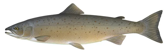 Atlantic salmonRecorded here1 placeThe River TamarOver river reach
Illustration: Knepp, Timothy, via Wikimedia Commons, public domain; resized and trimmed to fit
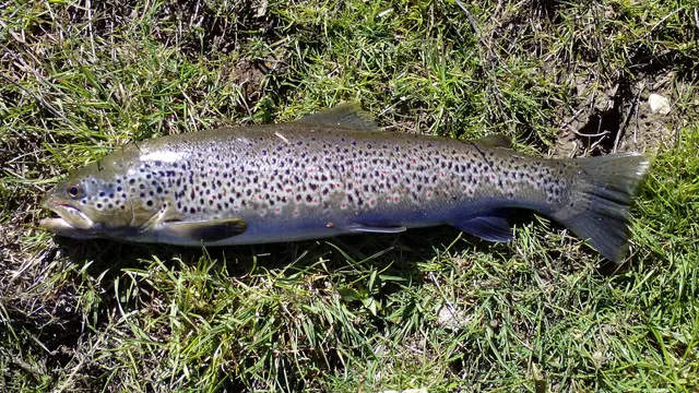 Brown troutRecorded here1 placeThe River TamarOver river reach
Photo: Robermix, via Wikimedia Commons, CC0; resized and trimmed to fit
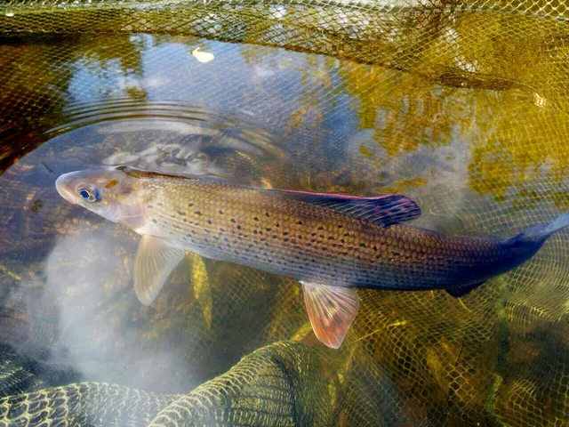 GraylingRecorded here1 placeThe River TamarOver river reach
Photo: High Plains Grifter, via Wikimedia Commons, CC BY-SA 4.0; resized; shared under the same licence


What these strengths mean
- Recorded here
- At least one credible public account of this species being caught here. That is all it means.
- How breadth is counted
- A fish documented at six marks is shown as six marks: breadth never raises the strength on its own. A fishery account describes the fishing; a recorded catch reports one specific catch. How evidence is weighed.
How people fish it
Practised here: Fly fishing.
Baits and lures for these fish
The baits and lures each of the fish above is commonly taken on, from that fish’s own page. This is what works for the fish, not a report of what people use on this particular water — local knowledge and the conditions on the day still decide.
Lures
How to catch them: Salmon fishing · Brown trout fishing · Grayling fishing
Rods, reels and rigs for them: Atlantic salmon · Brown trout · Grayling
The ground and the water
- The ground
- The river that forms almost the whole of the boundary between Devon and Cornwall, with five main tributaries — the Inny, Carey, Ottery, Lyd and Thrushel. This page covers the whole river: the map position is its middle, not somewhere anybody fishes from.
Not to be confused with The Tamar estuary, which is a separate place on different ground.
Through the year
A rivers overview calls it the region's most consistently productive salmon river and, in the same guide, says salmon numbers are well down on historic levels. Only the second is a statement about now.
Safety
Cold water shock — Can cause serious injury or death
General safety for this kind of ground, not a finding about this place.
Water around these islands stays cold enough all year to trigger cold water shock — involuntary gasping and hyperventilation on sudden immersion, which can cause somebody to inhale water in the first seconds regardless of swimming ability.
What reduces it: Wear a buoyancy aid where immersion is credible. If immersed, float on your back until the initial response passes rather than trying to swim immediately.
Rules and access
Licence
A rod licence is required for freshwater rod fishing in England, issued by the Environment Agency — except on the River Tweed, which the licence does not cover even in England. Children under 13 do not need one.
Permission to fish
Separate. Almost all fishing rights are held by a club, association, riparian owner or navigation authority, and the licence does not grant access to any of them.
Particular to this water: This page describes a river as a whole, not anywhere on it a person may fish. Almost all of the fishing is privately owned or let to angling associations, a rod licence is a separate requirement from permission, and salmon and sea trout are subject to byelaws and conservation measures that are amended. No beat, pool, season date or catch limit is published here: ask the association or owner controlling the water, and the Environment Agency.
Beyond what is stated above, FishingHQ does not know the current access position here. Freshwater rod fishing in England requires a current rod licence AND separate permission from whoever controls the fishing, which is frequently a club, riparian owner or navigation authority rather than a public body. Close seasons, byelaws and local rules apply and change. Check with the Environment Agency and with the controlling club or owner before going.
Who holds the answer:
- The Environment Agency, for rod licensing, close seasons and fisheries byelaws in England.
- The club, association, riparian owner or navigation authority that controls the fishing.
- The environmental regulator for England, which issues the rod licence, makes fisheries byelaws and enforces them.
- The equivalent Welsh environmental body, which administers fisheries in Wales and has set salmon and sea trout measures differently from England.
- The owner, club, syndicate or commercial fishery controlling the water, whose permission is separate from and additional to any licence.
- The body managing any marine protected area, national park or designated site where the fishing takes place.
- The national conservation body, for protected species and habitat designations that override general rules.
- The angling association, estate or riparian owner controlling the reach, which is the only route to permission
Nearby fishing
Other publicly documented places within about 40 km, by distance. Positions are approximate public geography and are never exact marks.
- The Tamar estuary — 10–25 km · Estuary
- Whitsand Bay and Tregantle — 25–40 km · Surf beach
- Widemouth Bay — 25–40 km · Surf beach
- Plymouth Hoe — 25–40 km · Promenade
- Mount Batten — 25–40 km · Breakwater
- Looe — 25–40 km · Charter departure port
- Bude breakwater — 25–40 km · Breakwater
- Plymouth Breakwater — 25–40 km · Breakwater
Sources for this place
- Freshwater Fishes of the British Isles — HarperCollins (New Naturalist 75), 1992 (Reference work)Relied on for: Distribution, habitat requirements and biology of the freshwater fishes of Britain and Ireland named here.States this directlyCitation checked — the work exists and is described correctly
- Trout & Salmon — Bauer Media (Specialist angling publication)Relied on for: Long-running published description of British and Irish game angling practice by river, beat and season.FishingHQ's interpretation of what it saysCitation checked — the work exists and is described correctly
- General angling website restatements of established technique — Various (Credible secondary source)Relied on for: Widely restated public descriptions of which waters are conventionally fished and how, recorded as practitioner consensus rather than as scholarship, and not relied on for access, permission or any current rule.Background and mechanism onlyCitation checked — the work exists and is described correctly
- The Angler's Outlook: Devon and Cornwall fishing guide — The Angler's Outlook (Credible secondary source)Relied on for: Which game and coarse fish each Westcountry river is known for, its character as a spate or moorland river, and that salmon numbers are well below historic levels.States this directlyPassage read and verified
How FishingHQ labels evidence is explained in the evidence policy. Last reviewed 2026-08-16.
Something wrong or out of date?
If something on this page has changed, email us from your own account using the link that fits, with a link to where you saw the change if you can. Every report is checked by a person before anything is changed, and a report never appears on the site by itself. Please don’t send exact private marks.
Before you go
- Fish documented here
- 3 at this place itself. See them.
- Getting there
- Not recorded. FishingHQ holds no sourced description of the way in.
- Rules particular to this water
- This page describes a river as a whole, not anywhere on it a person may fish. Source not tied: no recorded source has been matched to this statement.
- Almost all of the fishing is privately owned or let to angling associations, a rod licence is a separate requirement from permission, and salmon and sea trout are subject to byelaws and conservation measures that are amended. Source not tied: no recorded source has been matched to this statement.
- No beat, pool, season date or catch limit is published here: ask the association or owner controlling the water, and the Environment Agency. Source not tied: no recorded source has been matched to this statement.
Nothing here is watched for change. Sources and who to ask.
- Hazards particular to this place
- None recorded for this place; the hazards of the wider coast or water still apply.
Check before you travel
- Whether you may fish here, and whether a licence or permit is needed — start with the Environment Agency.
- Who holds the fishing right on the stretch you mean to fish, and the river level.
- Anything recorded here was true when it was read; it is not watched for change.