The Tweed at Coldstream
River reach · Fresh water · in The River Tweed
The lower river where it stops being in a country and starts being between two. Here the Tweed is itself the Anglo-Scottish border, Coldstream on the Scottish bank and Northumberland on the other, and Smeaton's bridge across it listed twice for the same arches — Category A in Scotland, Grade II in England. Big, broad, steady water in the Kelso-to-Coldstream stretch the letting trade calls the super-prime beats. An angler here is inside the Tweed district whichever bank they stand on, which is why this reach is recorded.
Safety: moving water and currents — can cause serious injury or death. One more point applies here.
FishingHQ describes what this place is, not whether you may fish it. Access, permits and who to ask.
What you can catch here
Documented at this place, grouped by how you would be fishing, with how strongly the sources support each one. This is what has been written down, not a forecast, and being listed is never permission to fish.
From the shore · 3
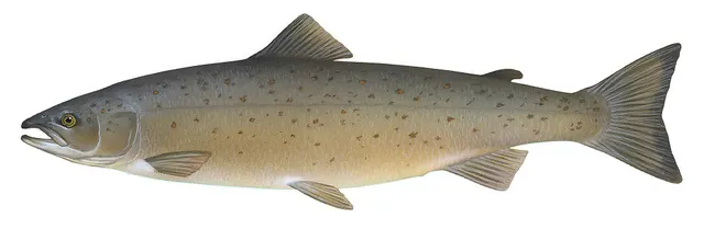 Atlantic salmonCharacteristic of this water1 placeThe Tweed at ColdstreamOver river reach
Illustration: Knepp, Timothy, via Wikimedia Commons, public domain; resized and trimmed to fit
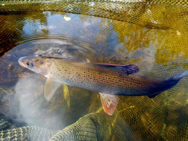 GraylingCharacteristic of this water1 placeThe Tweed at ColdstreamOver river reach
Photo: High Plains Grifter, via Wikimedia Commons, CC BY-SA 4.0; resized
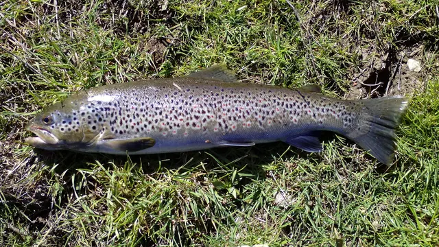 Brown troutRegular local target1 placeThe Tweed at ColdstreamOver river reach
Photo: Robermix, via Wikimedia Commons, CC0; resized and trimmed to fit


From a boat · 1
What these strengths mean
- Characteristic of this water
- This water is strongly identified with this species by the sources that cover it.
- Regular local target
- Fishing sources describe this as a normal local target here, not merely as caught.
- How breadth is counted
- A fish documented at six marks is shown as six marks: breadth never raises the strength on its own. A fishery account describes the fishing; a recorded catch reports one specific catch. How evidence is weighed.
How people fish it
Practised here: Fly fishing.
Methods the sources name for this ground. Each one is explained in full on its own page.
- Salmon fly fishing
Swinging a fly across a river on a tight line for a fish that has stopped eating — the method behind almost all Atlantic salmon fishing, and the one where fly speed and depth matter more than what the fly resembles.
- Spinning
Casting an artificial lure and retrieving it so that it moves like something alive — the most direct form of lure fishing.
- Float fishing
Suspending a bait at a controlled depth beneath a buoyant indicator — the most visual, most controllable and most widely applicable method in angling.
Baits and lures for these fish
The baits and lures each of the fish above is commonly taken on, from that fish’s own page. This is what works for the fish, not a report of what people use on this particular water — local knowledge and the conditions on the day still decide.
Lures
How to catch them: Salmon fishing · Brown trout fishing
The ground and the water
- The ground
- The lower river where it stops being in a country and starts being between two. Here the Tweed is itself the Anglo-Scottish border, Coldstream on the Scottish bank and Northumberland on the other, and Smeaton's bridge across it listed twice for the same arches — Category A in Scotland, Grade II in England. Big, broad, steady water in the Kelso-to-Coldstream stretch the letting trade calls the super-prime beats. An angler here is inside the Tweed district whichever bank they stand on, which is why this reach is recorded.
- Exposure
- Open lowland river in the Merse. The hazard is the water rather than the weather: this is wide, heavy river a long way down a large catchment, and it carries whatever the Cheviots and the Border hills have had.
Not to be confused with The Junction Pool, which is a separate place on different ground.
Through the year
The lower river takes fish through the season and is most associated with the autumn run that the Tweed is known for. No dates here: the statutory season and the conservation measures are the Commission's and are amended.
Safety
Moving water and currents — Can cause serious injury or death
Wading a large salmon river in strong flow over shifting gravel and cobble is the principal hazard. Current strong enough to take a wader off their feet arrives at less depth than expected, the bed moves, and a person swept into a heavy pool in waders is in serious difficulty. Levels can rise quickly from rain in the hills with no local weather at all.
What reduces it: Wear a wading belt tightly and use a staff, wade with the current rather than against it, do not wade above heavy water, and get out at the first sign of rising level or colouring. Do not wade at night in water you have not read in daylight.
Worse when:
- After rain in the upper catchment, which raises the river hours later and without local warning.
- In autumn and winter, when the water is coldest and the days shortest.
- At night during the summer sea trout fishery, when the bed cannot be read.
Cold water shock — Can cause serious injury or death
Water temperature is low for much of the season the river is best known for. Sudden immersion triggers gasping and hyperventilation, and swimming ability is lost within the first minute — which in a river in waders is the minute that matters.
What reduces it: Wear a wading belt and consider an inflatable buoyancy aid, do not fish alone in heavy water, and if immersed, get feet downstream, float and control breathing before attempting to reach the bank.
Rules and access
Licence
Scotland has no general rod licence for freshwater fishing. That is the opposite of the position in England and Wales, and it is not a relaxation.
Permission to fish
The whole question. Fishing rights on almost every river and loch belong to a proprietor, estate, angling association or district salmon fishery board, and permission must come from them.
FishingHQ does not know the current access position here. Scotland has no general rod licence, and the fishing rights on almost every river and loch belong to somebody: a proprietor, an estate, an angling association or a district salmon fishery board. Permission is a separate question from access, and both change. Check with the relevant fishery board or association before going.
Particular to this water: The Tweed is let, beat by beat: the fishing is a property right, and a rod on a named beat is there because it was booked. No Environment Agency rod licence is required anywhere in this catchment, including its English ground, because the district is regulated under its own legislation — do not read that as the fishing being open. The Tweed carries its own statutory season, fly-only periods and conservation measures, all set by instruments that are amended. No date or killing limit is published here. Ask the River Tweed Commission and the beat.
Who holds the answer:
- The district salmon fishery board for the catchment, where the water holds migratory fish.
- The proprietor, estate or angling association that holds the fishing rights.
- The Scottish Government, for freshwater fisheries policy and protection orders.
- The river's statutory commission, which is the governing body for fisheries on the whole Tweed catchment including the English parts.
- The owner of the fishing rights or their letting agent, whose permission is required to fish any beat.
- The national fisheries and conservation authorities of Scotland and England, for salmon conservation regulation, stock assessment and species protection.
- The river trust or foundation working on habitat, catchment management and juvenile monitoring in the system.
- The biosecurity and invasive species authorities of both countries, for the equipment cleaning requirements that apply to anglers moving between waters.
- The River Tweed Commission, which regulates fishing across the whole Tweed district under the Tweed Regulation Order and is the authority for seasons, methods and conservation measures on both sides of the border
- The proprietor, estate or angling association letting the beat, which holds the fishing right and is the only route to permission
- The local angling associations at Peebles, Innerleithen, Galashiels, Selkirk, Kelso, Coldstream and Berwick, which hold club water on the main river and its tributaries
Nearby fishing
Other publicly documented places within about 40 km, by distance. Positions are approximate public geography and are never exact marks.
- The Junction Pool — 10–25 km · Confluence
- The Needle's Eye — 10–25 km · Rock mark
- Spittal and Goswick — 10–25 km · Beach
- Eyemouth — 25–40 km · Harbour wall
- Holy Island and the Lindisfarne causeway — 25–40 km · Island
- St Abbs Head — 25–40 km · Headland
- Bamburgh and Budle Bay — 25–40 km · Beach
- Torness and Skateraw — 25–40 km · Rock mark
Sources for this place
- Freshwater Fishes of the British Isles — HarperCollins (New Naturalist 75), 1992 (Reference work)Relied on for: Distribution, habitat requirements and biology of the freshwater fishes of Britain and Ireland named here.States this directlyCitation checked — the work exists and is described correctly
- Trout & Salmon — Bauer Media (Specialist angling publication)Relied on for: Long-running published description of British and Irish game angling practice by river, beat and season.FishingHQ's interpretation of what it saysCitation checked — the work exists and is described correctly
- General angling website restatements of established technique — Various (Credible secondary source)Relied on for: Widely restated public descriptions of which waters are conventionally fished and how, recorded as practitioner consensus rather than as scholarship, and not relied on for access, permission or any current rule.Background and mechanism onlyCitation checked — the work exists and is described correctly
How FishingHQ labels evidence is explained in the evidence policy. Last reviewed 2026-08-16.