Punta de Teno, Tenerife
Headland · Salt water · in Tenerife
The north-western corner of Tenerife: a basalt point at the foot of the Teno massif, with boulder and lava ledge at the water's edge, high cliffs behind and deep water immediately offshore.
Safety: cliffs and rock platforms — can cause serious injury or death. One more point applies here.
FishingHQ describes what this place is, not whether you may fish it. Access, permits and who to ask.
What you can catch here
Documented at this place, grouped by how you would be fishing, with how strongly the sources support each one. This is what has been written down, not a forecast, and being listed is never permission to fish.
From the shore · 4
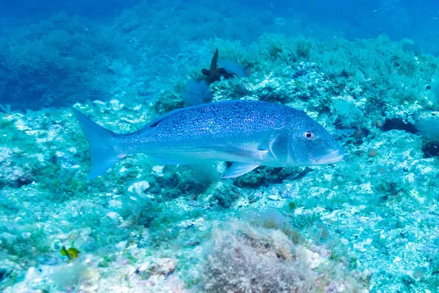 Common dentexRegular local target1 placePunta de Teno, TenerifeOver headland
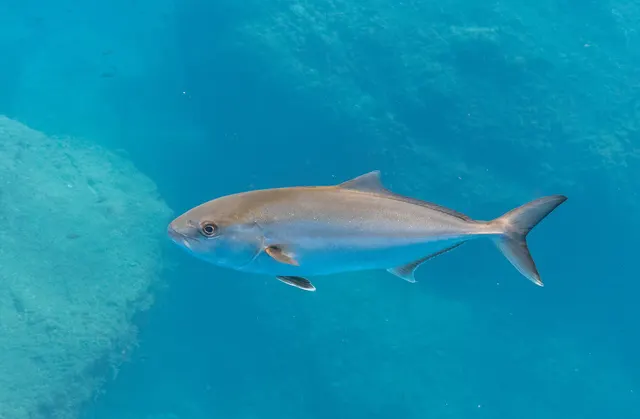 Greater amberjackRegular local target1 placePunta de Teno, TenerifeOver headlandAround Jan–Feb, Sept–Dec
- White seabreamRegular local target1 placePunta de Teno, TenerifeOver headland
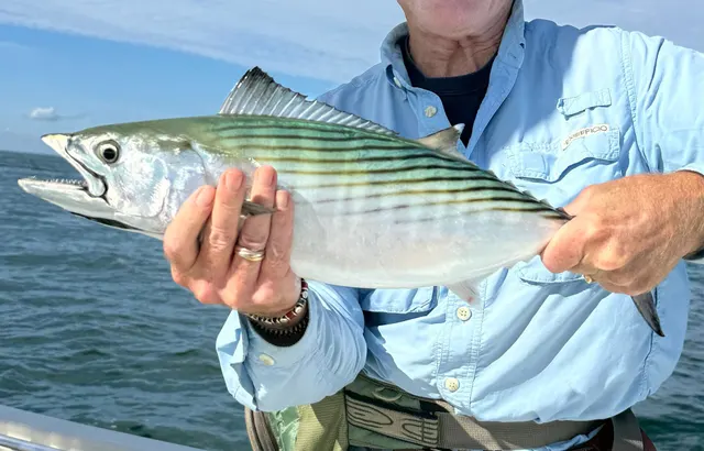 Atlantic bonitoSeasonal1 placePunta de Teno, TenerifeOver headlandAround Jun–Oct
What these strengths mean
- Regular local target
- Fishing sources describe this as a normal local target here, not merely as caught.
- Seasonal
- Well supported, and concentrated in part of the year rather than spread through it.
- How breadth is counted
- A fish documented at six marks is shown as six marks: breadth never raises the strength on its own. A fishery account describes the fishing; a recorded catch reports one specific catch. How evidence is weighed.
Fish documented nearby, not here
Nothing below has been documented at Punta de Teno, Tenerife itself. Each one has been documented at a named place on the same ground, and the places are listed with it. Treat this as what the water around here holds rather than as a catch list for this mark.
Widely documented on this ground
Documented at three or more neighbouring places, fished a way this place is also fished. That is a pattern about the ground rather than about any one mark, and it is the closest this site comes to saying you will probably meet a fish somewhere nothing has been written about.
From the shore
- Atlantic horse mackerel — documented at El Médano, Tenerife; Punta Rasca, Tenerife; Candelaria
- Mediterranean parrotfish — documented at Garachico; Candelaria; The El Sauzal coast (+1 more)
- Bogue — documented at Garachico; Candelaria; Puerto de la Cruz
- Salema porgy — documented at Garachico; Candelaria; Puerto de la Cruz
Also documented at neighbouring places
One or two accounts each, on the ground around here. Enough to know the fish is caught in these waters; not enough to say anything about this place.
From the shore
- Comber — documented at Garachico; The El Sauzal coast
- Common octopus — documented at Garachico; Puerto de la Cruz
- European squid — documented at Puerto de la Cruz
- Red porgy — documented at The El Sauzal coast
How people fish it
Practised here: Sea fishing, Spearfishing.
Methods the sources name for this ground. Each one is explained in full on its own page.
- Float fishing
Suspending a bait at a controlled depth beneath a buoyant indicator — the most visual, most controllable and most widely applicable method in angling.
- Spinning
Casting an artificial lure and retrieving it so that it moves like something alive — the most direct form of lure fishing.
- Shore diving
Entering and leaving the water from land under your own power — the most accessible spearfishing and the one where the entry and exit are the dangerous part.
The ground and the water
- The ground
- The north-western corner of Tenerife: a basalt point at the foot of the Teno massif, with boulder and lava ledge at the water's edge, high cliffs behind and deep water immediately offshore.
- Exposure
- Exposed to the north-westerly swell and to the acceleration of the trade wind around the corner of the island.
Through the year
The months the sources attach to each species here. Where a species carries no season it is listed underneath rather than assumed to run through the year.
| Species | J | F | M | A | M | J | J | A | S | O | N | D |
|---|---|---|---|---|---|---|---|---|---|---|---|---|
| Greater amberjack — regular local target, recorded in September, October, November, December, January, February. | ||||||||||||
| Atlantic bonito — seasonal, recorded in June, July, August, September, October. |
Recorded here with no season stated: Common dentex, White seabream.
Safety
Cliffs and rock platforms — Can cause serious injury or death
Anglers are swept from rock platforms by individual large sets rather than by the average sea, which means the conditions that kill frequently look survivable for the twenty minutes before they arrive. Wet rock, weed and a swell running onto a sloping platform remove any chance of recovery.
What reduces it: Watch the water for a full set cycle before committing to a position, know the escape route and how long it takes, wear a flotation aid rather than carry one, never fish a platform alone, and treat a rising swell forecast as a reason not to go rather than a reason to be careful.
Sun, dehydration and fatigue — Can cause injury needing treatment
Long summer sessions on shadeless rock produce dehydration and heat exhaustion, and both degrade judgement and coordination well before they produce collapse, on ground where both are what keep somebody safe.
What reduces it: Carry substantially more water than the session appears to need, fish the ends of the day rather than the middle of it in high summer, and treat shade and a stopping time as part of the plan.
Rules and access
FishingHQ does not know the current access position here. The Canary Islands are an autonomous community licensing their own recreational sea, boat and underwater fishing, separately from mainland Spain, and the archipelago carries marine reserves in which fishing and diving are restricted or prohibited on boundaries a visitor cannot see from the shore. Measures change. Check the current position with the Canarian government's fisheries administration before going.
Particular to this water: Underwater fishing is licensed and regulated separately from rod fishing throughout this jurisdiction, with its own age, equipment and distance requirements, and holding a rod licence is not permission to spearfish.
Who holds the answer:
- The Canarian government's fisheries administration, which licenses recreational sea and underwater fishing in the archipelago.
- The island council, for local measures and for access to the coast.
- The marine reserve administration, where the water is inside a reserve.
- The Canary Islands autonomous government's fisheries department, which administers recreational sea fishing licensing and rules in Canarian waters.
- The management authority of any marine protected area in which fishing is proposed.
- The Spanish national fisheries administration for offshore waters and for matters reserved to it.
- The harbour authority of the port used, for berthing, launching and charter arrangements.
- International fishery bodies whose measures apply to billfish and large pelagic species taken in Atlantic waters.
Nearby fishing
Other publicly documented places within about 40 km, by distance. Positions are approximate public geography and are never exact marks.
- Los Gigantes, Tenerife — 10–25 km · Harbour wall
- Garachico — 10–25 km · Rock platform
- Playa San Juan and Alcalá, Tenerife — 10–25 km · Harbour wall
- San Sebastián de La Gomera — 25–40 km · Harbour wall
- Puerto Colón, Adeje, Tenerife — 25–40 km · Charter departure port
- Puerto de la Cruz — 25–40 km · Harbour wall
- Los Cristianos, Tenerife — 25–40 km · Charter departure port
- La Gomera — 25–40 km · Island
Sources for this place
- EMODnet — the European Marine Observation and Data Network — The European Commission, assembled from the national hydrographic offices, geological surveys and marine institutes of the member states (Scientific institute)Relied on for: Charted bathymetry, seabed substrate and seabed habitat for European sea areas, assembled from the national hydrographic and geological surveys, at the resolution the product publishes.States this directlyCitation checked — the work exists and is described correctly
- The European Environment Agency's assessments of Europe's waters, seas and coasts — European Environment Agency, Copenhagen (Conservation authority)Relied on for: Assessment of Europe's coasts and regional seas, including the condition of coastal water bodies, the pressures recorded on them and the coverage of designated sites.Background and mechanism onlyCitation checked — the work exists and is described correctly
- FAO Species Identification Guides for Fishery Purposes and the FAO Species Catalogues — Food and Agriculture Organization of the United Nations (Scientific institute)Relied on for: Identification, distribution and habitat association of the fishes and invertebrates of the Mediterranean and Black Sea.States this directlyCitation checked — the work exists and is described correctly
- FishBase: a global information system on fishes — Froese, R. and D. Pauly, eds. — FishBase Consortium (Scientific institute)Relied on for: Recorded distribution, depth range and habitat association of the species named for this ground.States this directlyPassage read and verified
- RNLI water safety guidance: cold water shock and Float to Live — Royal National Lifeboat Institution (Water-safety or diver-training authority)Relied on for: Cold water shock and the immersion response, tidal cut-off, and water-safety guidance for shore anglers and small-craft users. Cited for the mechanism, which does not vary by coast.States this directlyPassage read and verified
How FishingHQ labels evidence is explained in the evidence policy. Last reviewed 2026-08-18.