Jubilee Park, Hopkins River
Jetty · Brackish water
The last shore access to the estuary upstream, at Allansford: a concrete and bluestone wall and large floating fishing platforms, with an 11 m deep hole in front of the jetties that the agency names as a good spot for mulloway, and an angler track upstream to The Pass.
FishingHQ describes what this place is, not whether you may fish it. Access, permits and who to ask.
What you can catch here
Documented at this place, grouped by how you would be fishing, with how strongly the sources support each one. This is what has been written down, not a forecast, and being listed is never permission to fish.
From the shore · 4
- Black breamRegular local target1 placeJubilee Park, Hopkins RiverOver jetty
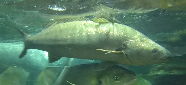 Dusky kobRegular local target1 placeJubilee Park, Hopkins RiverOver jetty
Photo: タウナギ, via Wikimedia Commons, CC BY-SA 4.0; resized and trimmed to fit; shared under the same licence
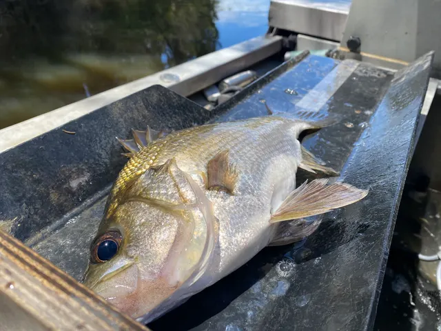 Estuary perchRegular local target1 placeJubilee Park, Hopkins RiverOver jetty
Photo: Bryce Watts-Parker, via iNaturalist, CC BY; resized
- Yellow-eye mulletRegular local target1 placeJubilee Park, Hopkins RiverOver jetty

What these strengths mean
- Regular local target
- Fishing sources describe this as a normal local target here, not merely as caught.
- How breadth is counted
- A fish documented at six marks is shown as six marks: breadth never raises the strength on its own. A fishery account describes the fishing; a recorded catch reports one specific catch. How evidence is weighed.
How people fish it
Methods the sources name for this ground. Each one is explained in full on its own page.
- Ledgering
Fishing a bait on the bottom held by a weight, with no float — the simplest way to fish at distance, in depth, or in wind.
- Float fishing
Suspending a bait at a controlled depth beneath a buoyant indicator — the most visual, most controllable and most widely applicable method in angling.
The ground and the water
- The ground
- The last shore access to the estuary upstream, at Allansford: a concrete and bluestone wall and large floating fishing platforms, with an 11 m deep hole in front of the jetties that the agency names as a good spot for mulloway, and an angler track upstream to The Pass.
Getting there
What public sources describe, last checked 2026-10-23. Car parks fill, services change and a path existing is not a path anybody may use — none of this is a guarantee of availability and none of it is permission to be anywhere.
- Getting to it
- By Jubilee Park Road from Allansford.
Where this access information comes from
- Hopkins River — Victorian Fisheries Authority (Government fisheries body)Relied on for: The state fisheries agency's Hopkins River page: this access point, the fish it recommends here by shore and boat, how they are fished, and the parking, platforms, ramps and hazards it describes.States this directlyPassage read and verified
What is there
Slipway or launch
A concrete boat ramp, as the agency lists; not a statement about launching today.
Through the year
Mulloway mostly spring to autumn; the other key fish all year.
Rules and access
Particular to this water: A caravan park and an angling club are here; the boat ramp is popular, so give launching boats room.
Beyond what is stated above, FishingHQ does not know the current access position here. Victoria licenses recreational fishing in its marine waters, with exemptions the state lists; bag limits, size limits and closed seasons are set by the Victorian Fisheries Authority and change. Marine national parks and marine sanctuaries lie along the bays and coast, and their boundaries are shown by the state's fishing guide app. A pier or jetty being public is not a statement that fishing from it is allowed today. Check the current position with the Victorian Fisheries Authority before going. This water is tidal and transitional, so the freshwater regime may also apply above the tidal limit: FishingHQ does not know the current access position here. Victoria's recreational fishing licence also covers its lakes and rivers, and the state sets their limits and seasons, which change. Check the current position with the Victorian Fisheries Authority before going.
Who holds the answer:
- The Victorian Fisheries Authority, which issues the recreational fishing licence and publishes the rules, limits and closures.
- Parks Victoria, for the state's marine national parks and sanctuaries.
- The operator of the pier or jetty, for whether it is open.
- The Victorian Fisheries Authority, which issues the recreational fishing licence and publishes the inland rules.
- The Victorian Fisheries Authority, which issues the recreational fishing licence and sets and publishes the catch limits, size limits and closed seasons.
- Service Victoria, the state's service through which the licence is bought.
- Parks Victoria, which manages the marine national parks and marine sanctuaries where fishing is prohibited.
- The operator of a pier or jetty, for whether it is open.
- The Victorian Fisheries Authority: issues the recreational fishing licence and publishes the limits, closed seasons and bait-collection rules for this water.
Nearby fishing
Other publicly documented places within about 40 km, by distance. Positions are approximate public geography and are never exact marks.
- Deakin University jetty, Hopkins River — 2–5 km · Jetty
- Hopkins River estuary — 2–5 km · Estuary
- Hopkins Point Road bridge — 2–5 km · Bridge
- The Blue Hole, Hopkins River — 5–10 km · Estuary mark
- Proudfoots platforms, Hopkins River — 5–10 km · Jetty
- Lyndoch platforms, Hopkins River — 5–10 km · Jetty
Sources for this place
- Hopkins River — Victorian Fisheries Authority (Government fisheries body)Relied on for: The state fisheries agency's Hopkins River page: this access point, the fish it recommends here by shore and boat, how they are fished, and the parking, platforms, ramps and hazards it describes.States this directlyPassage read and verified
- Buy a Victorian recreational fishing licence — Service Victoria (State Government of Victoria) (Local authority, harbour or protected-area body)Relied on for: That Victoria licenses recreational fishing in all its waters, lakes, rivers and sea alike, with exemptions the state lists.States this directlyPassage read and verified
How FishingHQ labels evidence is explained in the evidence policy. Last reviewed 2026-10-23.
Something wrong or out of date?
If something on this page has changed, email us from your own account using the link that fits, with a link to where you saw the change if you can. Every report is checked by a person before anything is changed, and a report never appears on the site by itself. Please don’t send exact private marks.
Before you go
- Fish documented here
- 4 at this place itself. See them.
- Getting there
- Described from public sources, last checked 2026-10-23. Getting there.
- Rules particular to this water
- A caravan park and an angling club are here; the boat ramp is popular, so give launching boats room. From the body that sets it: Victorian Fisheries Authority and Service Victoria (State Government of Victoria), read 2026-10-23. Applies to: Jubilee Park, Hopkins River.
Nothing here is watched for change. Sources and who to ask.
- Hazards particular to this place
- None recorded for this place; the hazards of the wider coast or water still apply.
Check before you travel
- Whether you may fish here, and whether a licence or permit is needed — start with the Victorian Fisheries Authority.
- The tide times and the forecast for the day you go.
- Anything recorded here was true when it was read; it is not watched for change.