Cape Point
Headland · Salt water · in The Cape Peninsula and False Bay
The rock headland at the southern end of the Cape Peninsula, where the cold Atlantic side and the warmer False Bay side meet around a narrow point of Table Mountain sandstone. Deep water lies close in on both sides and the ground is steep boulder and rock platform with heavy kelp.
Safety: cliffs and rock platforms — can cause serious injury or death. One more point applies here.
FishingHQ describes what this place is, not whether you may fish it. Access, permits and who to ask.
This place is inside a protected area. Which parts may be fished, and what may be kept, is set by its zoning, not by anything listed here. Who to ask: SANParks. Rules and access.
What you can catch here
Documented at this place, grouped by how you would be fishing, with how strongly the sources support each one. This is what has been written down, not a forecast, and being listed is never permission to fish.
From the shore · 3
From a boat · 2
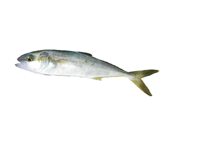 Yellowtail kingfishSeasonal1 place · 1 fishery account · 1 sourceCape PointOver headlandAround Jan–Apr, Nov–DecObserved December 2018
Photo: Hugues Evano (IFREMER, Délégation océan Indien (DOI), Département Ressources Biologiques et Environnement (RBE), F-97420 Le Port, France), via Wikimedia Commons, CC BY 4.0; resized
- BarracoutaSeasonal1 placeCape PointOver headlandAround May–Sept
_(Ifremer_00762-87437).jpg)
Spearfishing · 3
What these strengths mean
- Regular local target
- Fishing sources describe this as a normal local target here, not merely as caught.
- Seasonal
- Well supported, and concentrated in part of the year rather than spread through it.
- Repeatedly reported
- Several independent public accounts. Enough to say it happens more than once; not enough to call it a fishery.
- How breadth is counted
- A fish documented at six marks is shown as six marks: breadth never raises the strength on its own. A fishery account describes the fishing; a recorded catch reports one specific catch. How evidence is weighed.
Also associated with this ground
Recorded as present here without a documented method or strength behind them.
Galjoen · Bluefish · Blacktail · Fransmadam · John Brown
Fish documented nearby, not here
Nothing below has been documented at Cape Point itself. Each one has been documented at a named place on the same ground, and the places are listed with it. Treat this as what the water around here holds rather than as a catch list for this mark.
Widely documented on this ground
Documented at three or more neighbouring places, fished a way this place is also fished. That is a pattern about the ground rather than about any one mark, and it is the closest this site comes to saying you will probably meet a fish somewhere nothing has been written about.
From the shore
- Silver kob — documented at Strandfontein; Kalk Bay harbour wall; Gordon's Bay
Also documented at neighbouring places
One or two accounts each, on the ground around here. Enough to know the fish is caught in these waters; not enough to say anything about this place.
From the shore
- White steenbras — documented at Strandfontein
- Leerfish — documented at Gordon's Bay
- Bronze whaler — documented at Strandfontein
From a boat
- Silver kob — documented at Kalk Bay harbour wall; Gordon's Bay
How people fish it
Practised here: Sea fishing.
Methods the sources name for this ground. Each one is explained in full on its own page.
- Spinning
Casting an artificial lure and retrieving it so that it moves like something alive — the most direct form of lure fishing.
- Ledgering
Fishing a bait on the bottom held by a weight, with no float — the simplest way to fish at distance, in depth, or in wind.
- Light rock fishing
Ultralight lure fishing from the shore with tackle rated in single grams — a discipline that catches the fish everybody else steps over, and one FishingHQ held every component of and had never named.
- Jigging
Working a weighted lure with a rising-and-falling motion, usually vertically, so it behaves like a wounded or fleeing baitfish.
Baits and lures for these fish
The baits and lures each of the fish above is commonly taken on, from that fish’s own page. This is what works for the fish, not a report of what people use on this particular water — local knowledge and the conditions on the day still decide.
Lures
- Metal jigs — for Yellowtail kingfish
- Surface lures — for Yellowtail kingfish
The ground and the water
- The ground
- The rock headland at the southern end of the Cape Peninsula, where the cold Atlantic side and the warmer False Bay side meet around a narrow point of Table Mountain sandstone. Deep water lies close in on both sides and the ground is steep boulder and rock platform with heavy kelp.
- Exposure
- As exposed as anything on this coast. Two water masses meet here over deep water, the swell wraps round the point from both sides, and there is nothing between it and Antarctica. This is a mark that is unfishable far more often than it is fishable.
- Depth
- Deep close in on both sides, which is what puts pelagic species within casting range from rock — an unusual thing anywhere.
- Tide and flow
- Strong movement round the point where the two sides meet, with confused water and standing swell in a running sea. The interaction of tide and swell at the tip is what makes it both productive and lethal.
Through the year
Yellowtail are a warm-season proposition, roughly November to April. Snoek are winter. The real seasonality is the swell, and the number of genuinely fishable days here is small.
The months the sources attach to each species here. Where a species carries no season it is listed underneath rather than assumed to run through the year.
| Species | J | F | M | A | M | J | J | A | S | O | N | D |
|---|---|---|---|---|---|---|---|---|---|---|---|---|
| Barracouta — seasonal, recorded in May, June, July, August, September. | ||||||||||||
| Yellowtail kingfish — seasonal, recorded in November, December, January, February, March, April. |
Recorded here with no season stated: Hottentot, White musselcracker.
Safety
Cliffs and rock platforms — Can cause serious injury or death
Two water masses meet over deep water at a narrow rock point with swell wrapping in from both sides, so the sea here does not behave the way the sea a few hundred metres away does. A set can arrive from a direction the previous ten did not, onto rock that is steep and kelp-covered, with deep water immediately below.
What reduces it: Do not fish the tip in any swell. Watch for a long period before committing and understand that watching does not tell you as much here as it does elsewhere. Never fish it alone. A flotation aid is a reasonable precaution on any Cape rock mark and an obvious one here.
Worse when:
- Any south-westerly ground swell, which wraps round the point from both sides at once
- A spring tide, which increases the movement round the tip
- A hooked fish running into the kelp, which draws an angler down towards the water
Cold water shock — Can cause serious injury or death
Benguela water on the Atlantic side of the Cape is upwelled and genuinely cold — frequently colder in a summer south-easter than in midwinter, and capable of single figures in January. Immersion causes involuntary gasping and loss of breathing control within seconds, which is the mechanism that drowns people in the first minute, and it happens to anglers in shorts on a warm day.
What reduces it: Treat the west and south-west coast as cold water regardless of the air temperature or the month. Know that the coldest water of the year is often in summer. Do not fish low exposed ledges alone. A flotation aid buys back the minute that cold-water shock takes away.
Worse when:
- A hard summer south-easter, which drives the upwelling and drops inshore temperature sharply within a day
- Dressing for the air rather than for the water
- Rock-hopping to a stance at low water with a rising tide behind you
Rules and access
FishingHQ does not know the current access position here. South Africa licenses recreational sea angling nationally — a permit is required from the age of twelve — and layers over it a minimum size and daily bag limit set SPECIES BY SPECIES, a cumulative daily cap across all species, closed seasons on some fish, a prohibited list of species that may not be caught at all, and separate rules again for spearfishing, which is prohibited outright in estuaries. Much of the accessible coast additionally sits inside a marine protected area zoned into no-take and controlled areas, administered by a park, provincial or conservation authority rather than by the fisheries department. All of it changes, and the department's own guidance says adjustments may be forthcoming. Check the current position with the Department of Forestry, Fisheries and the Environment and with the authority that manages the protected area before going.
Particular to this water: Cape Point lies inside the Cape of Good Hope section of Table Mountain National Park. SANParks administers both land access and the Marine Protected Area zonation, and shore angling is permitted only in defined areas and with a SANParks activity permit in addition to the national fishing permit. Several nearby zones are no-take.
Who holds the answer:
- The Department of Forestry, Fisheries and the Environment, which issues the recreational fishing permit and sets the species, size, bag and closed-season measures.
- The authority managing the marine protected area — SANParks, CapeNature, Ezemvelo KZN Wildlife or the relevant provincial body — for whether this particular stretch of coast is open and on what terms.
- The harbour, municipality or landowner, for physical access to structures, beaches and rock.
- The Department of Forestry, Fisheries and the Environment, which issues the recreational fishing permit and sets the species, size, bag and closed-season measures
- The authority managing the marine protected area — SANParks, CapeNature, Ezemvelo KZN Wildlife or the relevant provincial body — for whether a particular stretch of coast is open and on what terms
- The harbour authority, municipality or landowner, for physical access to structures, beaches and rock
- The South African Post Office, which is where the recreational permit is actually bought
- SANParks, for park entry, for the activity permit and for the Marine Protected Area zonation
Nearby fishing
Other publicly documented places within about 40 km, by distance. Positions are approximate public geography and are never exact marks.
- Kalk Bay harbour wall — 25–40 km · Harbour wall
- Strandfontein — 25–40 km · Surf beach
- Gordon's Bay — 25–40 km · Harbour wall
Sources for this place
- JNCC species and habitat conservation advice — Joint Nature Conservation Committee (Conservation authority)Relied on for: Description, designation and habitat characterisation of the named coastal and marine features of the United Kingdom, and the species characteristically associated with them.States this directlyCitation checked — the work exists and is described correctly
- Cefas science, advice and data on marine and freshwater environments — Centre for Environment, Fisheries and Aquaculture Science (Government fisheries body)Relied on for: Marine environmental science for UK shelf seas: sediment characterisation, estuarine process, shellfish bed distribution, tidal range and the monitoring that describes them.States this directlyCitation checked — the work exists and is described correctly
- Sea Angler — Bauer Media (Specialist angling publication)Relied on for: Long-running published description of British sea angling practice by region, ground type and named mark.FishingHQ's interpretation of what it saysCitation checked — the work exists and is described correctly
- General angling website restatements of established technique — Various (Credible secondary source)Relied on for: Widely restated public descriptions of which places are conventionally fished and how, recorded as practitioner consensus rather than as scholarship, and not relied on for access, permission or any current rule.Background and mechanism onlyCitation checked — the work exists and is described correctly
How FishingHQ labels evidence is explained in the evidence policy. Last reviewed 2026-08-16.